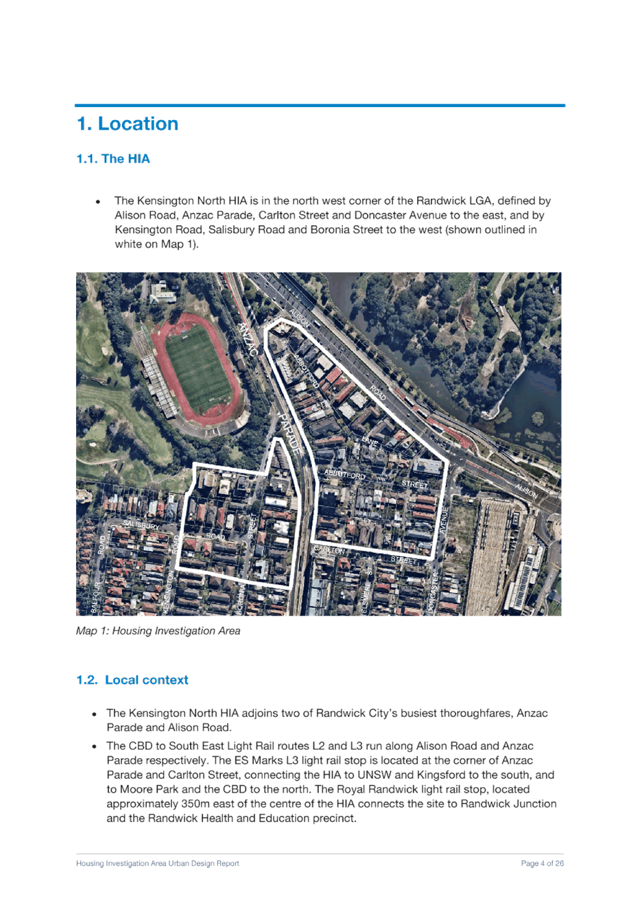
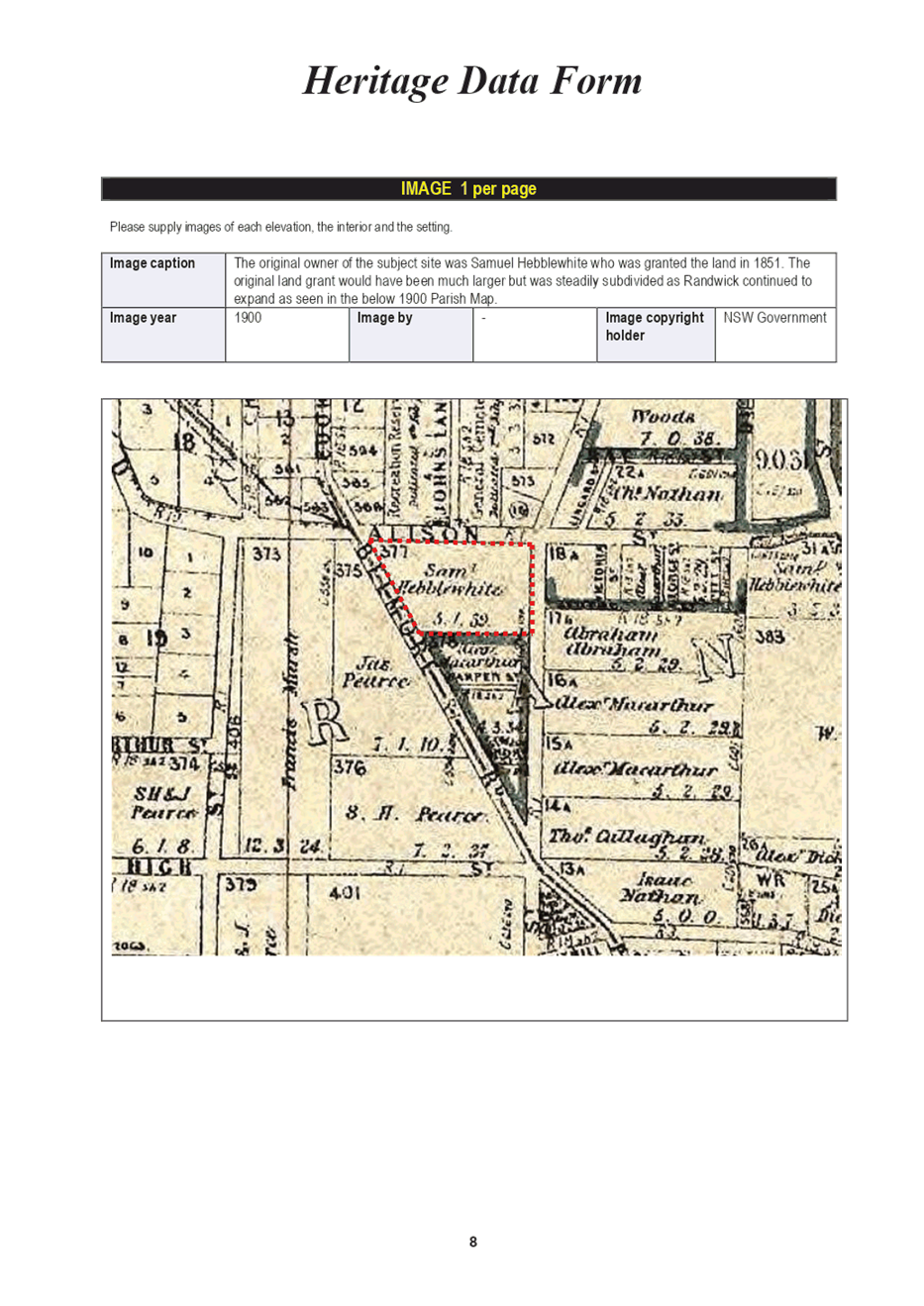
![]()
![]()

Randwick Local Planning Panel (Public) Meeting
Tuesday 18 May 2021
 |
|||
 |
|||
![]()
![]()
Randwick Local Planning Panel (Public) Meeting
Tuesday 18 May 2021
|
|||
|
|||
Randwick Local Planning Panel (Public) meeting
 |
Randwick Local Planning Panel (Public)
Notice is hereby given that a Randwick Local Planning Panel (Public) meeting
will be held in the Microsoft Teams on
Tuesday, 18 May 2021 at 1pm
Declarations of Pecuniary and Non-Pecuniary Interests
Address of RLPP by Councillors and members of the public
Privacy warning;
In respect to Privacy & Personal Information Protection Act, members of the public are advised that the proceedings of this meeting will be recorded.
General Reports
GR7/21 Randwick Comprehensive Planning Proposal 2021 - Review of housing investigation areas (including affordable housing contributions), heritage items in Randwick Junction Town Centre and housekeeping amendments................................ 1
Development Application Reports
Nil
Kerry Kyriacou
Director City Planning
Randwick Local Planning Panel (Public) meeting
|
General Report No. GR7/21
|
|
Subject: Randwick Comprehensive Planning Proposal 2021 - Review of housing investigation areas (including affordable housing contributions), heritage items in Randwick Junction Town Centre and housekeeping amendments |
Executive Summary
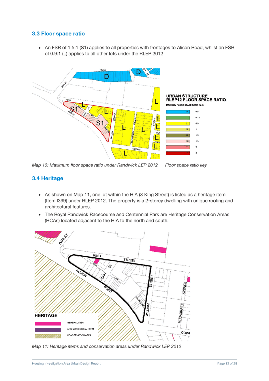
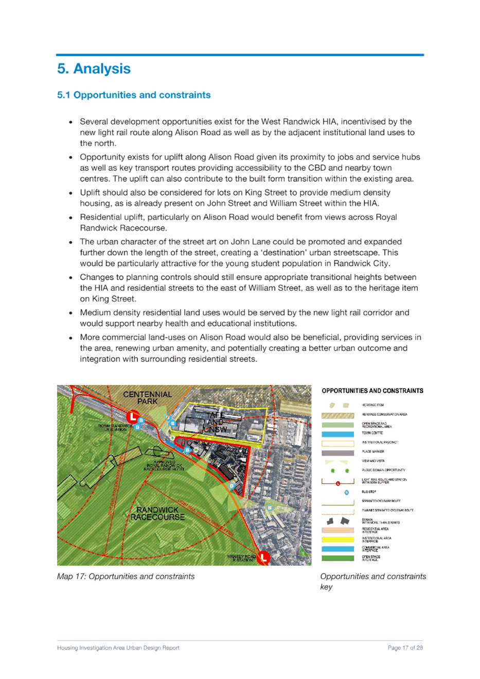
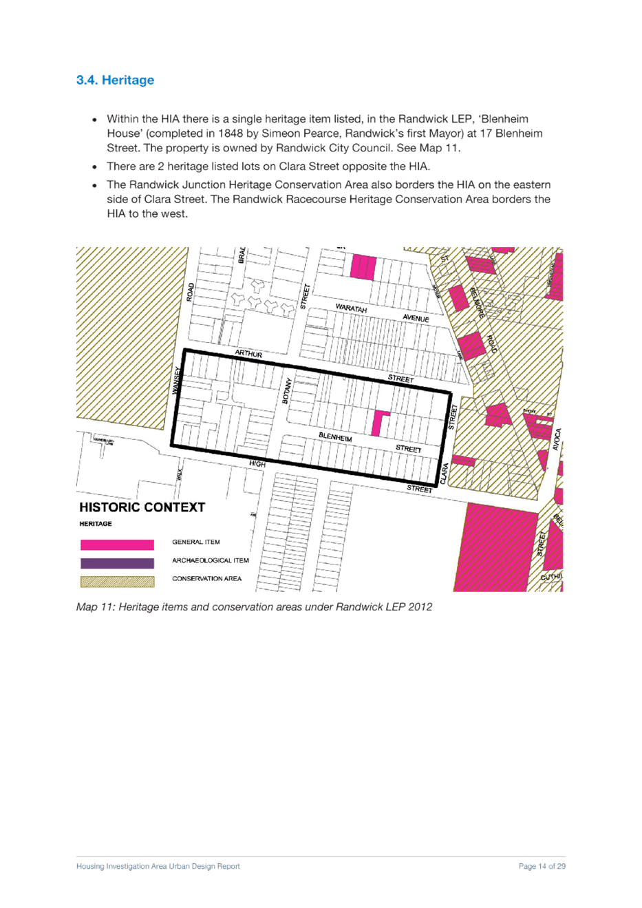
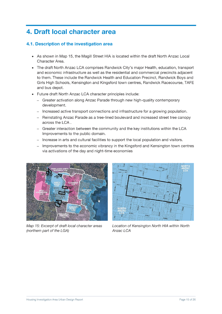
· The purpose of this report is to seek advice from the Panel in relation to Housing investigation areas, affordable housing contributions options in the housing investigation areas, heritage items identified as part of the Randwick Junction Town Centre Strategy and minor administrative and housekeeping amendments.
· Council at its March 2021 meeting resolved to request a revised report in relation to HIAs that addressed the following:
a. revising down building heights and densities within the Housing Investigation Area (HIAs);
b. an increased affordable housing contribution in identified HIAs;
c. the deletion of the Low-rise Housing Diversity Area;
d. incorporating the advice provided by the Randwick Local Planning Panel at its meeting of 8 March 2021 (Attachment 1) where not inconsistent with the above points;
e. maintaining all other actions outlined in the report where not inconsistent with the above points.
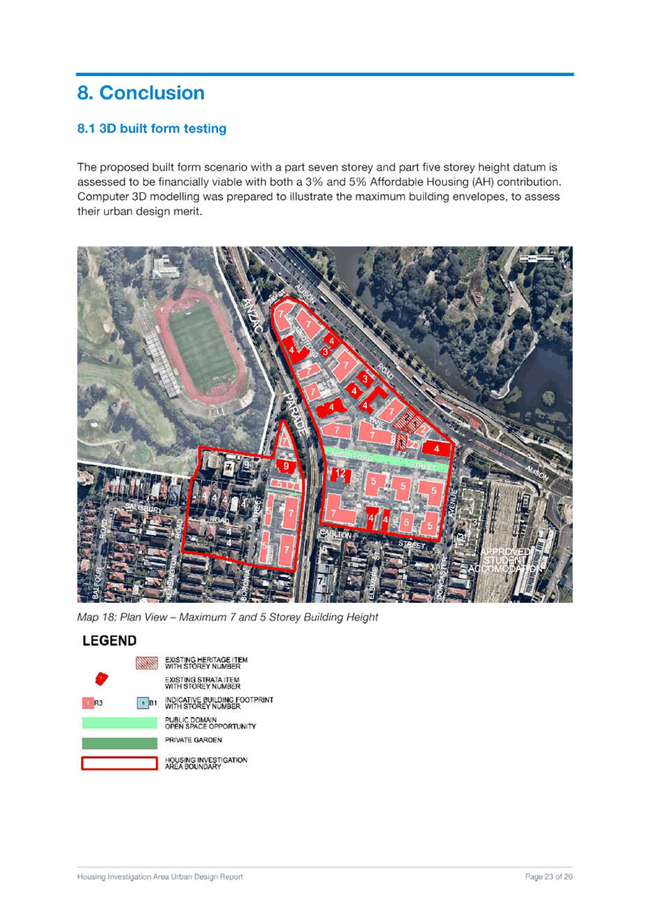
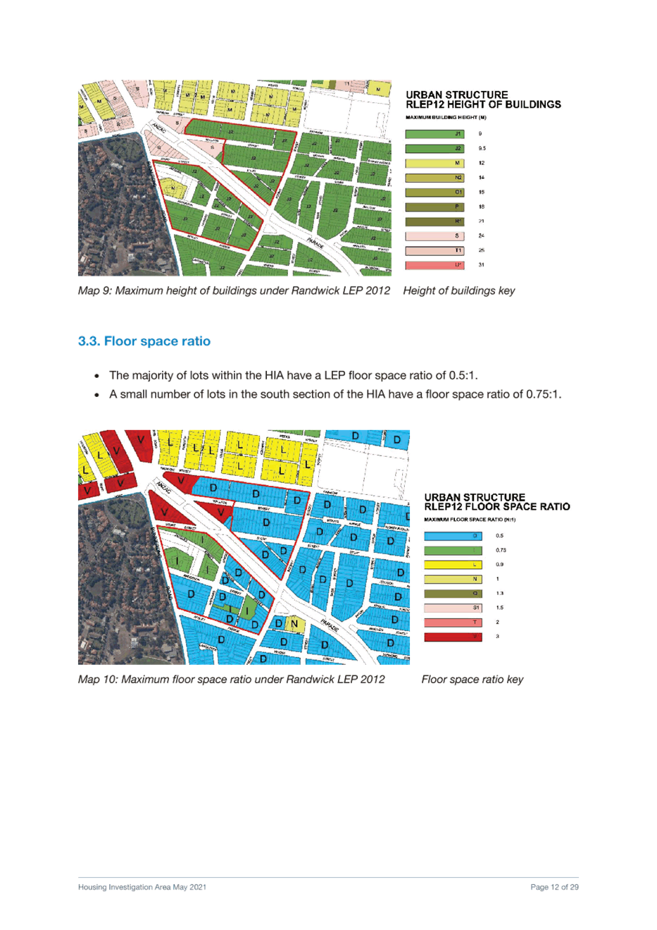
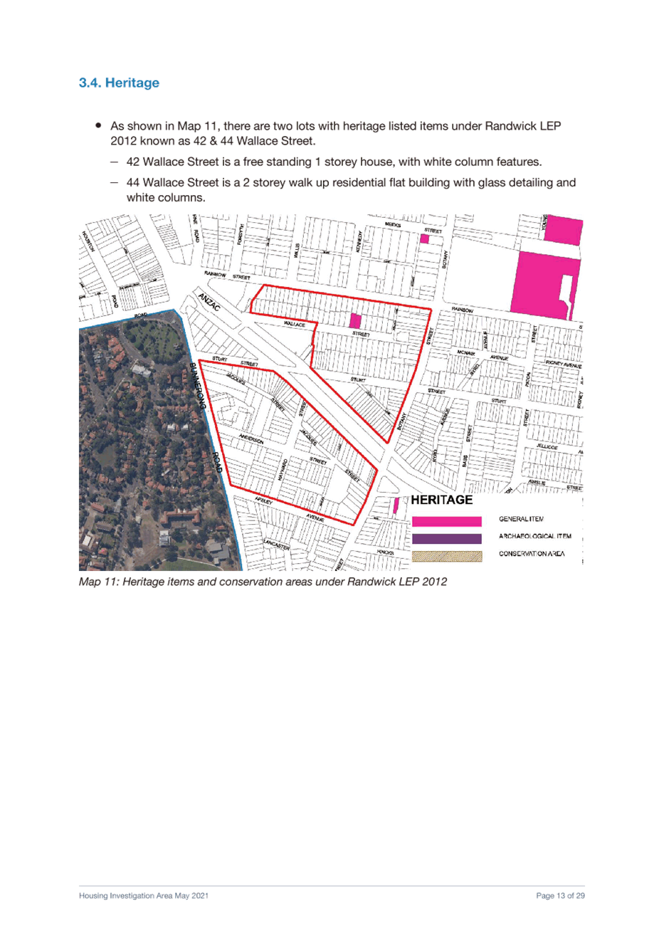
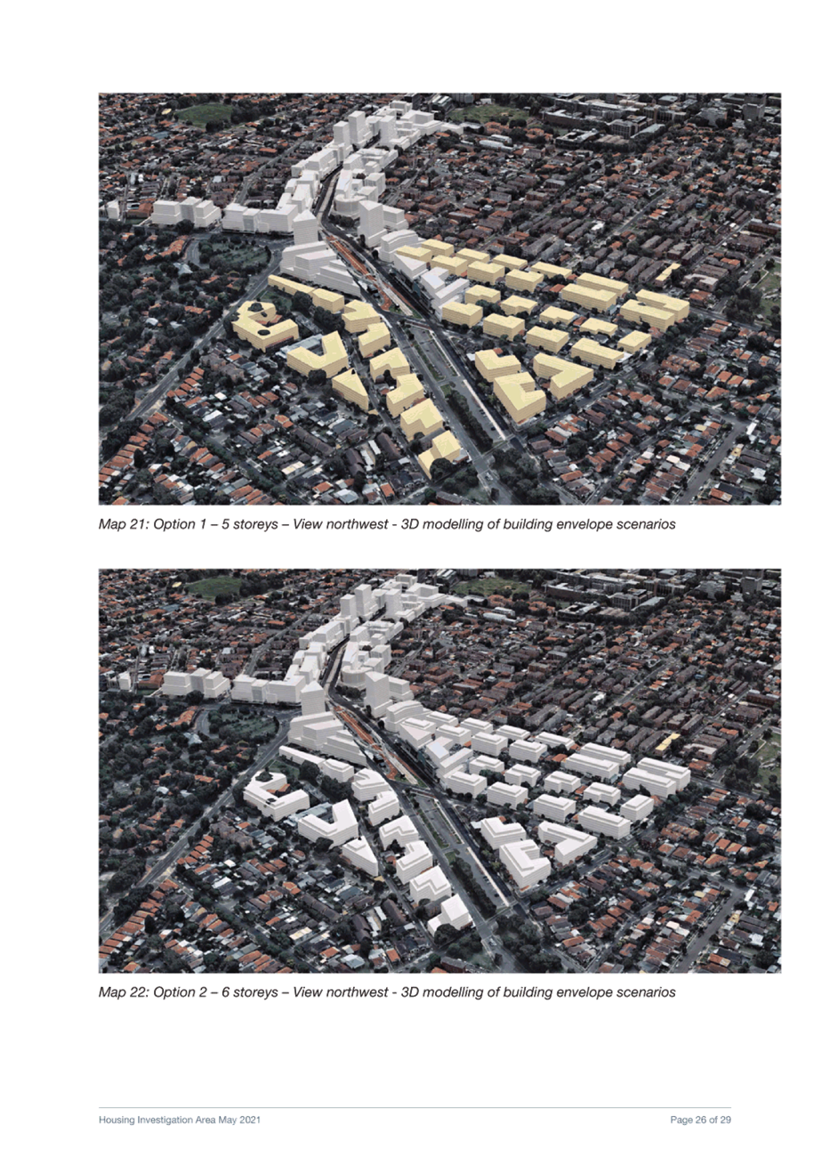
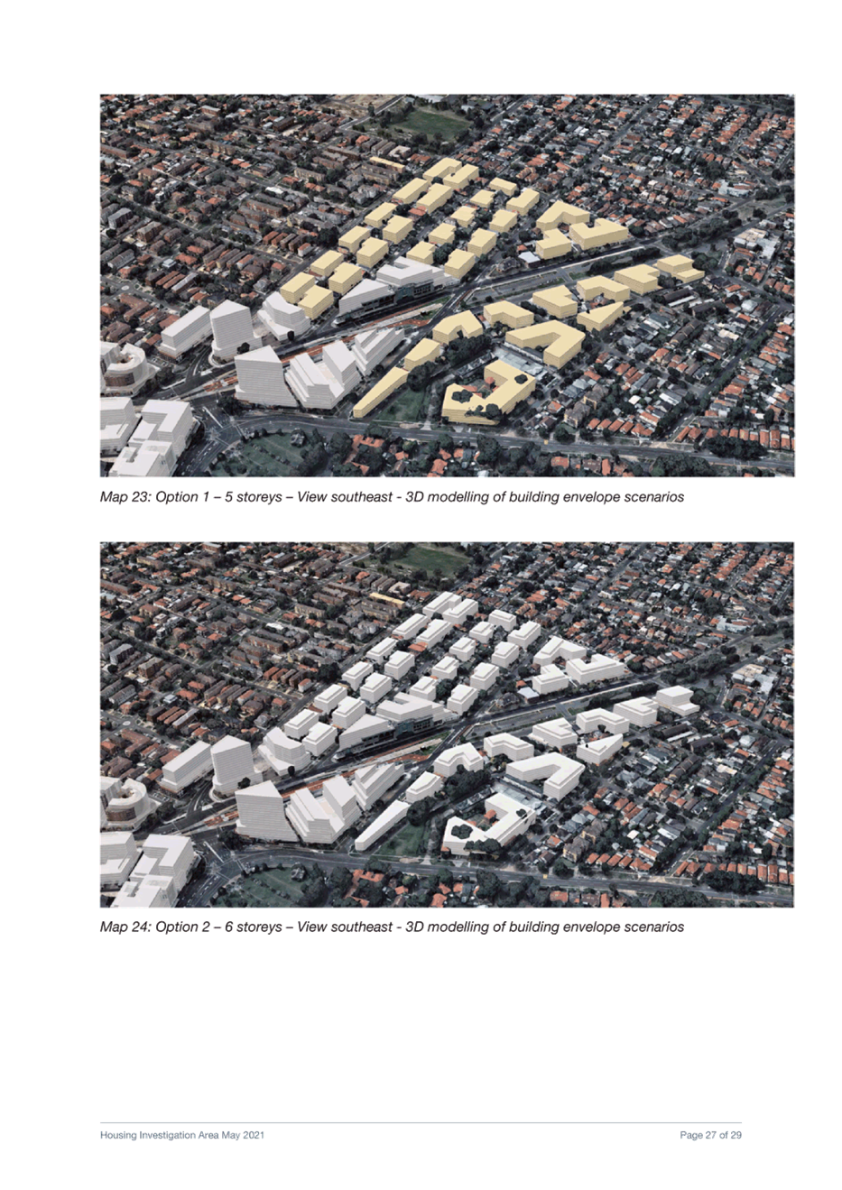
· No changes are proposed to the previously recommended heights and FSRs for the five housing investigation areas given the urban design analysis undertaken as well as the need to provide additional housing in accordance with Council’s Housing Strategy to meet the 6-10 year housing targets identified in the Eastern City District Plan.
· Changes are recommended in relation to affordable housing contributions in two of the housing investigation areas: Kensington North and part of West Randwick (R3 Medium Density residential area) to increase the affordable housing contribution from 3% to 5%. The remaining 3 HIAs and remainder of West Randwick (the area zoned B1) will maintain the previously recommended 3% affordable housing contribution.
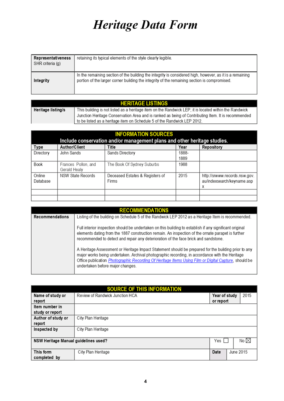
· New heritage items identified as part of the Randwick Junction Town Centre Strategy are recommended for inclusion in the Comprehensive Planning Proposal: 1 Belmore Road,167-171 Alison Road and 179-181 Alison Road, Randwick and the curtilage extension of No 60 Belmore Road (to include the adjoining address known as 25 Waratah Avenue Randwick)
· A number of amendments (including misdescriptions, zone boundary adjustments, exempt development provisions including markets and typographical errors) are recommended to Randwick Local Environmental Plan 2012 that have been identified during the operation of the instrument and are addressed in this report.
· The advice of the Panel along with its previous advice on 8 March, 6 April and 13 April will be included in the Comprehensive Planning Proposal report scheduled to be reported to Council’s 1 June 2021 Extraordinary Council Meeting. This report will be seeking endorsement of the Planning Proposal for submission to the Department of Planning, Industry and Environment (DPIE) for Gateway Determination.
|
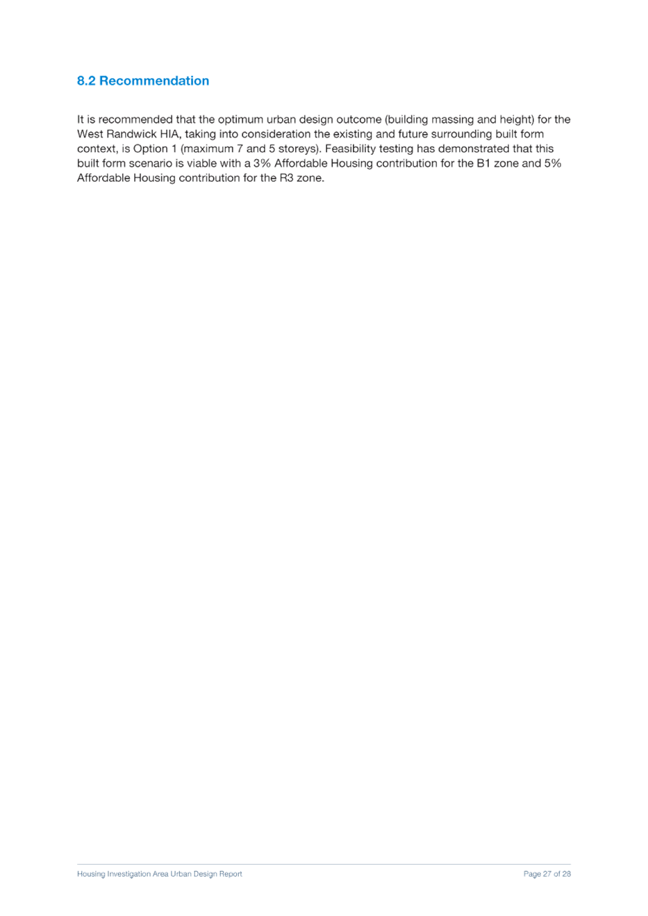
Housing Investigation Areas and Affordable Housing Contributions
a. That the Randwick Local Planning Panel advise Council that it supports the recommendations set out below:
i. Increase the affordable housing contribution scheme applicable in the Kensington North Housing Investigation Area (HIA) and proposed R3 zoned area of West Randwick HIA to 5% ii. Maintain a 3% affordable housing contribution scheme in the remaining areas, being Arthur Street HIA, Magill Street HIA, Kingsford South HIA and the proposed B1 zoned area of West Randwick HIA iii. Maintain the proposed building heights and FSRs for all HIAs as previously recommended to the RLPP on 8 March 2021 and Council on 23 March 2021
b. That the Randwick Local Planning Panel advises Council that it supports the inclusion of the following draft heritage items identified in Randwick Junction Planning Strategy in the draft Randwick Comprehensive Planning Proposal:
i. 1 Belmore Road,167-171 Alison Road and 179-181 Alison Road, Randwick ii. extend the curtilage of the heritage item at No 60 Belmore Road to include the adjoining address known as 25 Waratah Avenue Randwick
Housekeeping Amendments
c. That the Randwick Local Planning Panel advise Council that it supports the recommendations set out below in relation to the minor LEP and housekeeping amendments for inclusion in the draft Comprehensive Planning Proposal:
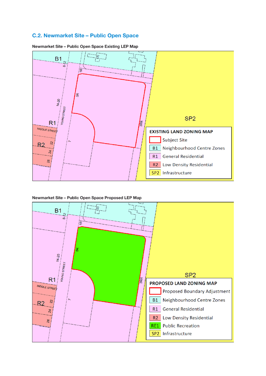
i. Correct ‘Randwick Environmental Heritage Conservation Area’ by renaming to ‘Randwick Environment Park Heritage Conservation Area’. ii. Correct the ‘Henry Fort Complex’ item by renaming to ‘Henry Head Fortification Complex’ iii. Correct the following addresses for heritage listed items on the former Prince Henry Hospital Site: · Item I179 ‘The Dam’ amended from 5R Coast Hospital Rd, Little Bay to 1 Coast Hospital Road, Little Bay · Item I180 ‘Former Male Lazaret Site’ from 5R Coast Hospital Rd, Little Bay to 1 Coast Hospital Road, Little Bay · Item I181 ‘Former Coast Hospital Services Area Retaining Walls’ from 5R Coast Hospital Road, Little Bay to 1 Coast Hospital Road, Little Bay. · Item I177 ‘Former Coast Hospital Water Tower’ from 5R Coast Hospital Road, Little Bay to 1 Coast Hospital Road, Little Bay iv. Add the Tramway Turnstile Building Complex – Royal Randwick Racecourse to Schedule 5 of the RLEP. v. Delete the following sites be from Schedule 5 in the RLEP: · Item I18 16 Douglas Street, Clovelly · Item I17 379-401 Clovelly Road, Clovelly vi. Amend the following heritage items descriptions and Heritage Conservation Areas map boundaries to rectify existing discrepancies: · Botany Bay National Park Heritage Conservation Area to align with the State Heritage Register Map. · Heritage Conservation Area the Figtree HCA to remove the Contemporary Campus Living Development. · Chinese Market Gardens Heritage Site I246 to correspond with the site boundary depicted on the State Heritage Item map. · curtilage of the existing Randwick Barracks Heritage Site I310 to include the courtyard spaces and motor garages. · existing Heritage Item Newmarket House I466 to fully cover Lot 38 DP 1264010. · existing Heritage Item Newmarket Sale Ring I292 so that it does not overlap the boundary of Lot 34. vii. Correct the following mapping anomalies relating to zonings on the Newmarket site (162-166 Barker Street, Randwick): · Lots 1 and 2 DP 159697 and SP 101097 be amended so that these lots are completely within the B1 Neighbourhood Centre Zone. · Lot 34 DP 1262464 be rezoned from R1 General Residential to RE1 Public Recreation to reflect the transformed use as public open space (newly created park within the Newmarket development site)
Community Activities, Events and Temporary Use of Land
d. That the Randwick Local Planning Panel advise Council that it supports the recommendations set out below in relation to Community Activities, Events and Temporary Use of Land for inclusion in the draft Comprehensive Planning Proposal:
i. That the development standards of Schedule 2 - Special events and temporary use of land (including erection of associated temporary structures such as stalls, shade structures, marquees, stages, etc) be amended as follows: · Include the land use term ‘market’ in subclause (1) · Include reference to ‘market’ in the provision to make it clear that the exempt provisions apply to markets · Clarify that the exempt provisions apply only to Crown land or under the care and control of Council (excluding schools) · Amend subclause (3) to ensure that the maximum area of all temporary structures is not to exceed 200m2 combined.
|
|
|
|
1.⇩
|
Comprehensive Planning Proposal - Housing - RLPP resolution 8 March 2021 |
|
|
2.⇩
|
Comprehensive Planning Proposal - Housing - Council resolution 23 March 2021 |
|
|
3.⇩
|
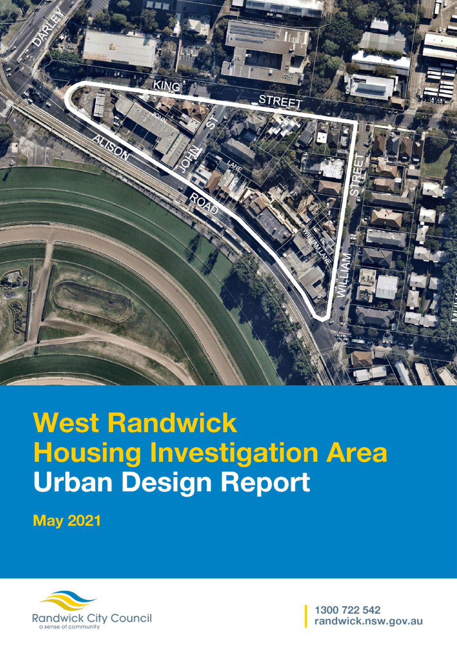
Draft West Randwick Urban Design Analysis report |
|
|
4.⇩
|
Draft Kensington North Draft Urban Design Analysis report |
|
|
5.⇩
|
Draft Arthur Street HIA Urban Design Analysis report |
|
|
6.⇩
|
Draft Magill Street HIA Urban Design Analysis report |
|
|
7.⇩
|
Draft Kingsford South HIA Urban Design Analysis report |
|
|
8.⇩
|
Randwick Junction Town Centre Post Exhibition Report - Council resolution - 27 April 2021 |
|
|
9.⇩
|
Randwick Junction Heritage Data Sheets |
|
|
10.⇩
|
Housekeeping LEP - heritage reports and LEP mapping |
|
Purpose
The purpose of this report is to seek advice from the Panel in relation to the following items subject to Council resolutions:
· Housing investigation areas
· Affordable housing contributions options in the housing investigation areas
· Heritage items identified as part of the Randwick Junction Town Centre Strategy
These Council resolutions (Attachments 2 and 8) followed consideration of the Panel’s advice and are addressed in this report.
This report also seeks Panel’s advice on a number of housekeeping amendments (including misdescriptions, zone boundary adjustments, exempt development provision including markets and typographical errors) to Randwick Local Environmental Plan 2012 that have been identified during the operation of the instrument.
Background
The Randwick Local Planning Panel considered at its March and April meetings the following six (6) separate topic related reports on components of the Randwick Comprehensive Planning Proposal:
· Randwick Comprehensive Planning Proposal – Housing investigation areas, affordable housing, low rise ‘diversity area’, minimum subdivision lot size and exemption to dual occupancy provisions of the Low Rise Housing Diversity Code (8 March 2021)
· Randwick Comprehensive LEP – Heritage Conservation (6 April 2021)
· Randwick Comprehensive Planning Proposal – Local Character (6 April 2021)
· Randwick Comprehensive Planning Proposal – Rezoning Requests (13 April 2021)
· Randwick Comprehensive Planning Proposal – Economic Development (13 April 2021)
· Randwick Comprehensive Planning Proposal – Environmental Resilience (13 April 2021)
Council considered the advice of the Panel in relation to each of these topic reports (other than the report on Heritage Conservation which has been deferred until 25 May 2021). The Local Character, Rezoning Requests, Economic Development and Environmental Resilience reports were endorsed for inclusion in the draft Comprehensive Planning Proposal. No changes were made to the recommendations for these reports following RLPP advice.
The Panel’s advice for this report will be included in the Randwick Comprehensive Planning Proposal consolidated report scheduled to be considered at the 1 June 2021 Extraordinary Council meeting.
Housing investigation areas and affordable housing contributions
On 8 March and 23 March 2021, the Local Planning Panel and Council respectively considered reports seeking to amend Randwick Local Environmental Plan 2012 (RLEP) to give effect to the Eastern City District Plan, Randwick Local Strategic Planning Statement and Randwick Housing Strategy. The objectives of the report were to:
· Provide housing capacity to meet 6-10 year housing target of 4,300 additional new dwellings by 2026
· Increase housing diversity and choice to support our growing and diverse population
· Increase the provision of affordable housing to meet housing demands of very low, low and medium income households
· Provide for low rise medium density housing through the local planning framework and exempt the LGA from the Low Rise Housing Diversity Code
Intended outcomes and planning rationale of the proposed LEP changes
To deliver housing capacity and diversity across Randwick City the report proposed the following approaches:
· Increase development densities in five Housing Investigation Areas (zoning, height of buildings and FSR)
· Mandate the delivery of affordable rental housing via an affordable housing contribution plan for the five Housing Investigation Areas
· Reduce the minimum lot size in the R2 Low Density Residential zone from 400m2 to 275m2 (with the exemption of heritage conservation areas)
· Align the minimum lot size for dual occupancies and the minimum lot size in the R2 zone, allowing for new dual occupancies to be built and subdivided on lots of 550sqm and more
· Reduce the minimum lot size for land within the Low Rise Diversity Area to 180m2
· Permit attached dwellings in the newly defined Low Rise Diversity Area within the R2 zone
Following the RLPP advice on 8 March 2021, Council resolved at the 23 March Ordinary Council Meeting as follows:
That Council:
1. note that the draft comprehensive planning proposal will be reported to Council in May 2021; and
2. note that community consultation in relation to all inclusions within the draft comprehensive planning proposal will be undertaken following endorsement of the proposal by Council in its whole form and once a Gateway determination is issued; and
3. requests a revised report containing the following:
a. revising down building heights and densities within the Housing Investigation Area (HIAs);
b. an increased affordable housing contribution in identified HIAs;
c. the deletion of the Low-rise Housing Diversity Area;
d. incorporating the advice provided by the Randwick Local Planning Panel at its meeting of 8 March 2021 (Attachment 1) where not inconsistent with the above points;
e. maintaining all other actions outlined in the report where not inconsistent with the above points.
This report addresses the outstanding matters raised by both the Panel and Council in relation to the housing investigation areas and affordable housing contributions that will apply in these identified areas.
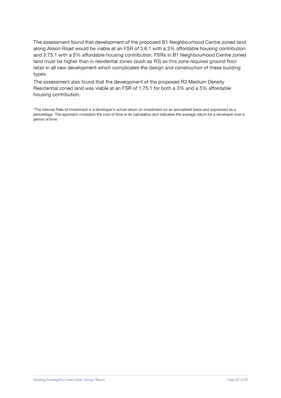
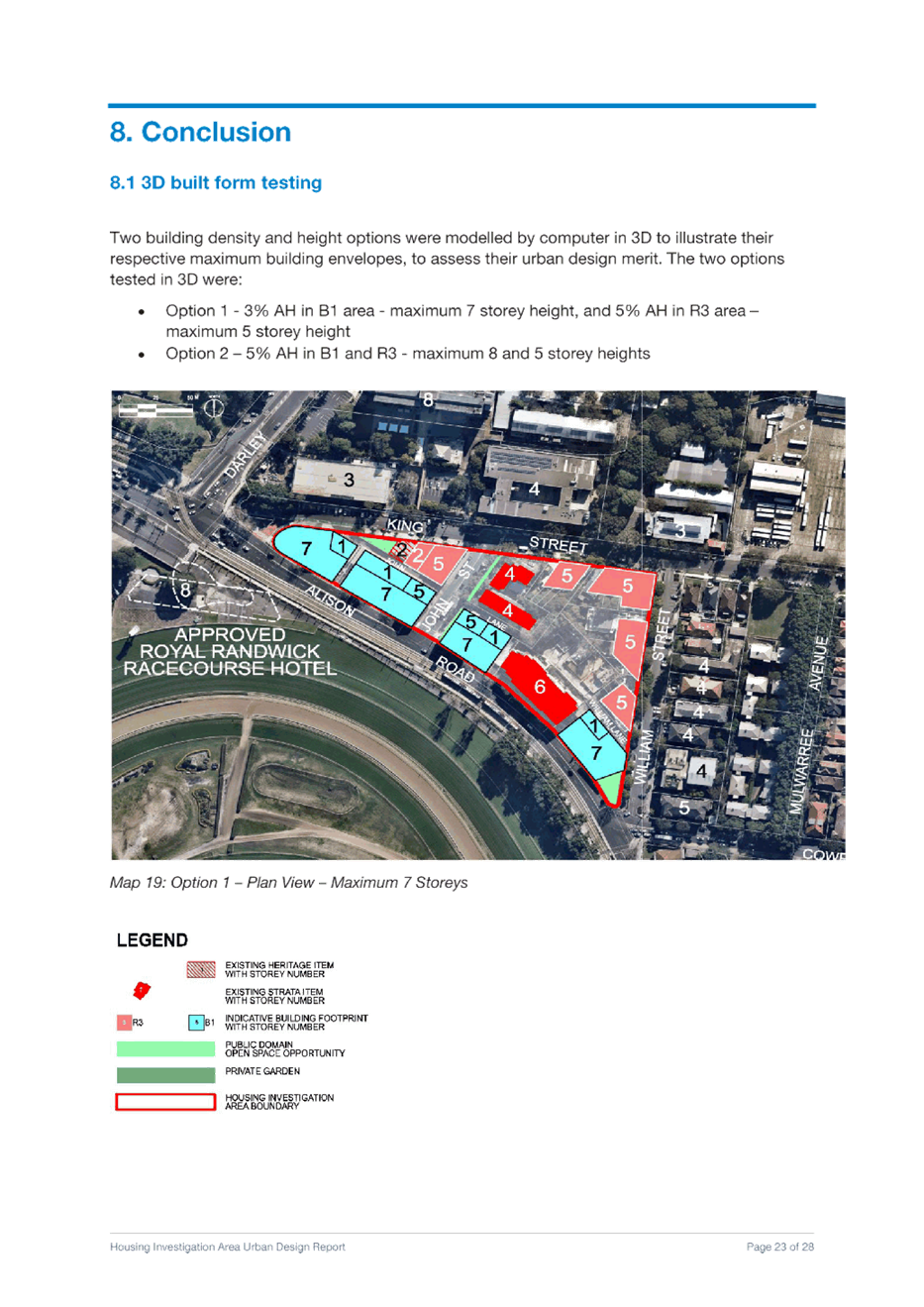
1. Housing Investigation Areas (HIAs)
Panel Comment:
The Panel supports the strategic intent and identification of the five (5) areas put forward for potential increased density and supporting controls.
Council officers’ response:
As considered in the Council report (23 April 2021) in relation to the RLPP comments, Council has noted the Panel’s support for the strategic location and intent of the five housing investigation areas for increased density.
Panel comment:
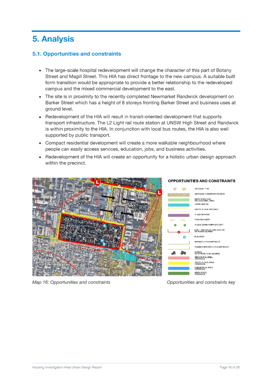
The site specific merits of each area should be supported with further urban design studies to consider appropriate transitions to surrounding areas, landscaped character, tree canopy and open space. The logic and rationale of the relationship between the height and floor space ratio (FSR) standards should be clear and should demonstrate that the built form outcomes and desired future character can be achieved. The urban design studies should be exhibited with the draft Randwick Local Environmental Plan (RLEP).
Council officers’ response
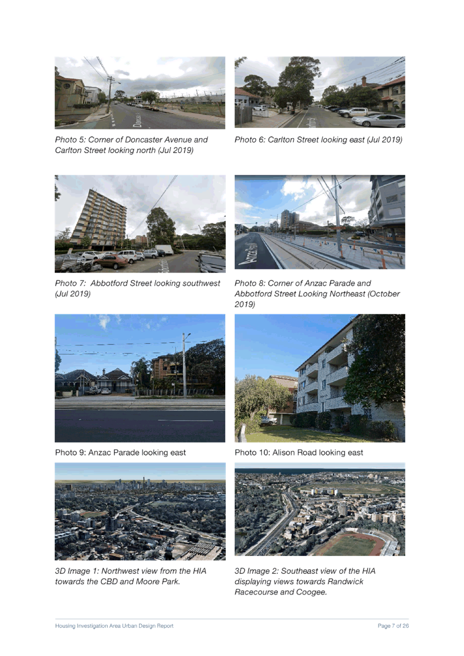
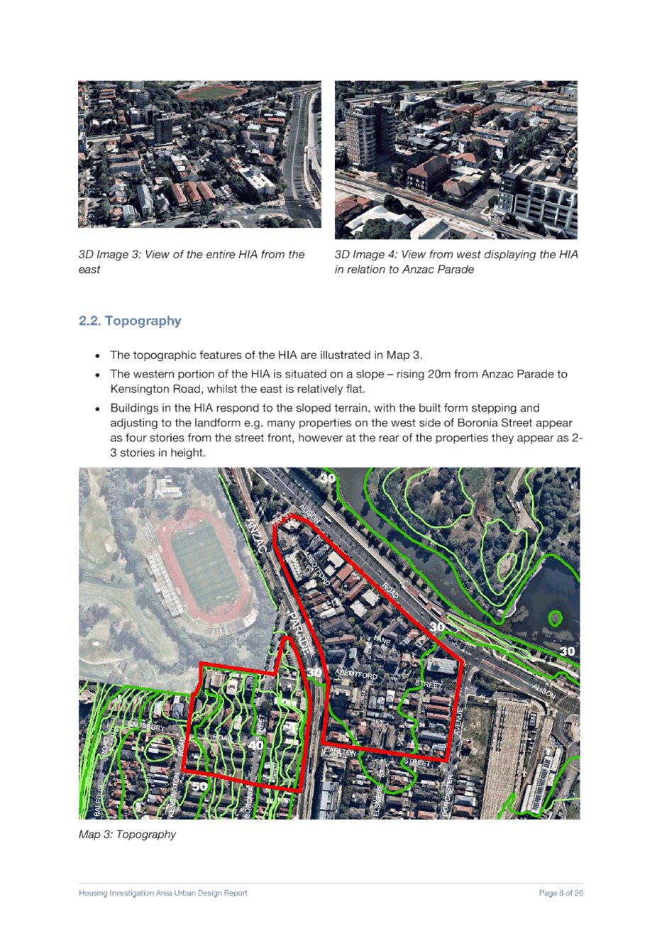
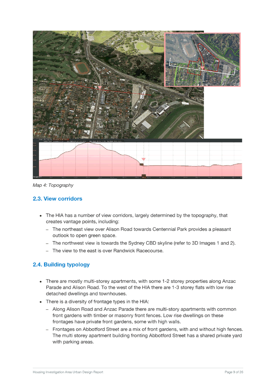
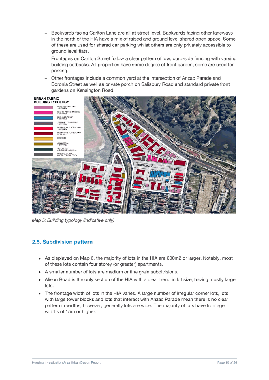
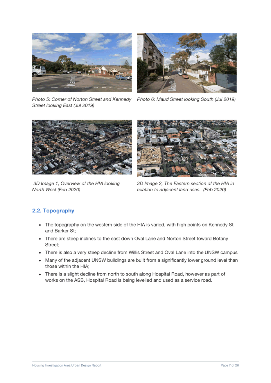
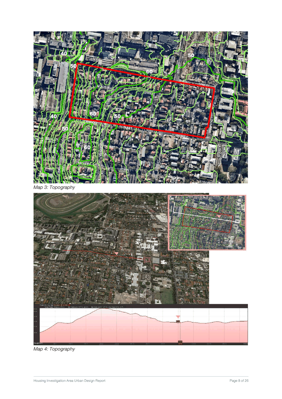
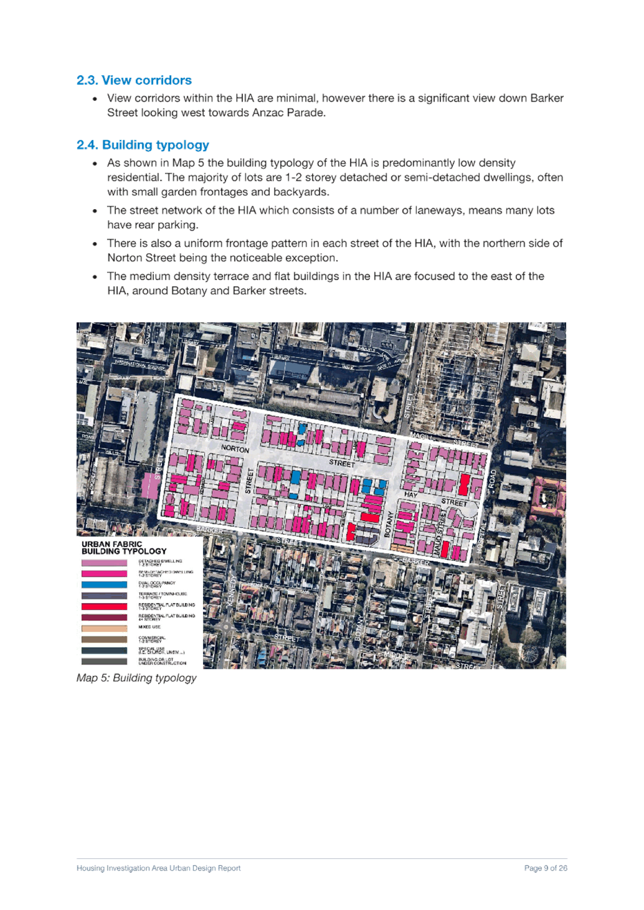
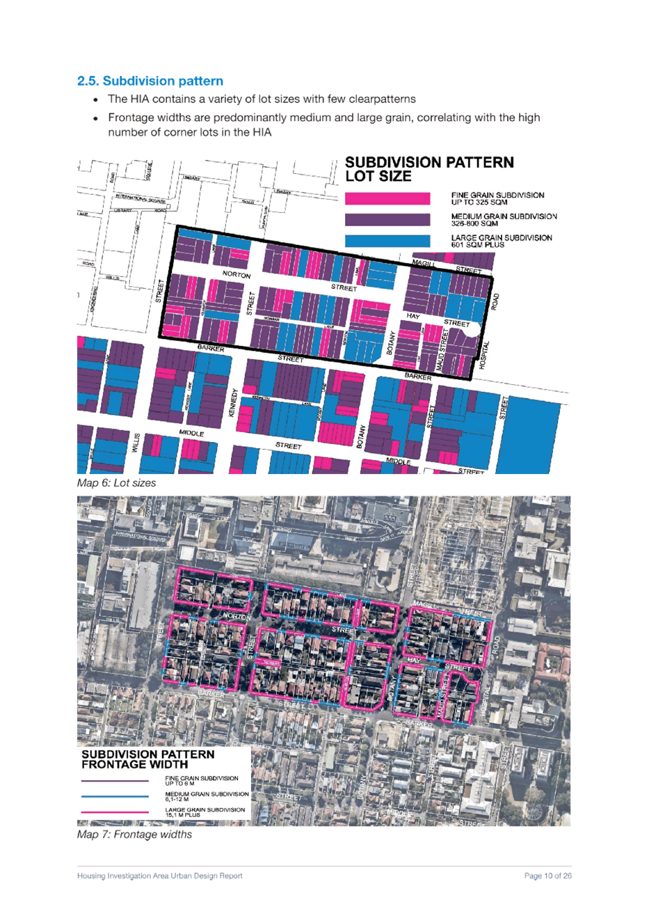
Council has prepared urban design analysis (UDA) reports for each HIA. These 5 UDA reports (Attachments 3-7) examine the local context, existing planning controls, opportunities and constraints and provide the strategic justification for the proposed planning controls. The analysis has been based on the following design principles:
· Provide height transitions from the B2 Local Centre zoned land (Kensington and Kingsford town centres) and Randwick Hospital campus to adjoining lower residential land
· Encourage development consistent with the draft local character statements
· Provide appropriate height transitions and landscape buffers to heritage properties
· Preserve solar access and appropriate scale to parks, public plazas, mid-block gardens
· Consider the potential for overshadowing of private gardens and living spaces
· Maximise the permeability of urban super blocks with new through-block pedestrian links
· Define building frontages and important corners in the urban ‘fabric’
· Enhance the legibility, amenity and interest of the public domain and the streetscape
· Build to the boundary in B1 Neighbourhood Centre zoned areas;
· Set back a minimum of 6m from front boundary for development in the R3 Medium Density Residential zone
· Assume carparking associated with development is below ground level
· Provide active podium frontages along commercial streets
· Maximise solar access to main retail streets (e.g. High Street)
· Provide consistent building heights along street frontages
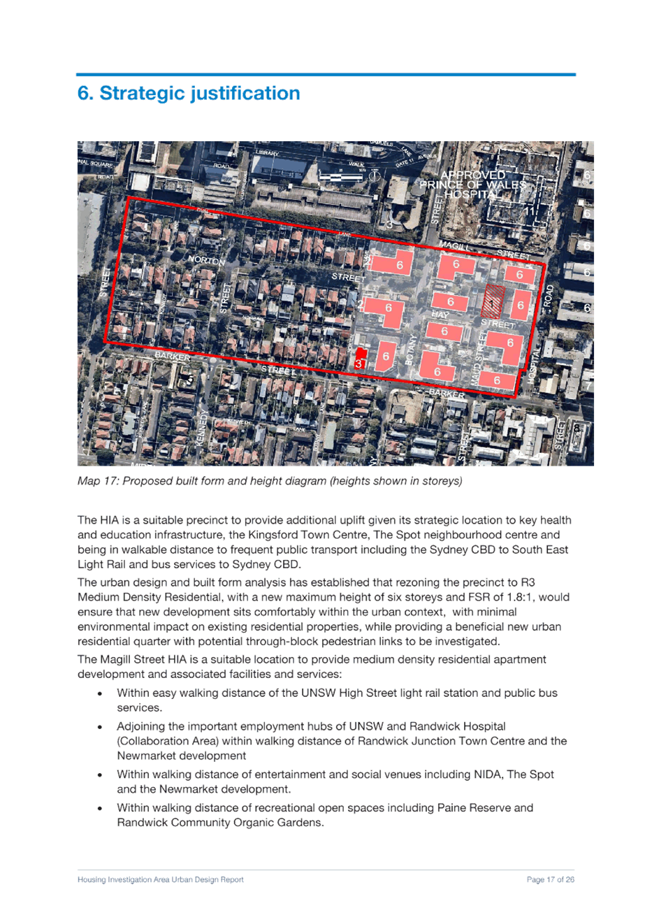
The height and floor space ratios proposed have been derived using these principles and the urban design analysis outlined in the UDA reports to ensure that proposed controls for each HIA is consistent with the strategic context and setting. In relation to the Council resolution to revise down building heights and densities within the Housing Investigation Area (HIAs), Council officers have undertaken a strategic place-based approach to ensure an appropriate urban form for each area. The HIAs are intended to progressively establish new (primarily residential) urban precincts that offer high quality contemporary urban living within convenient reach of public transport and within walking distance of many of Randwick City’s key businesses and services, health and educational campuses, open spaces and entertainment destinations.
The future desired character of the HIAs is for development to be consistent with the aims of the R3 Medium Density Residential zone (and in two cases the B1 Neighbourhood Centre zone) that provides for a variety of medium density housing types. The proposed mid-rise typologies can enhance the character of the neighbourhoods by encouraging high quality design outcomes in an area of high amenity.
The place-based approach considers the most appropriate urban design outcome for each HIA - the built form and scale of each precinct, and the public domain and street level experience for pedestrians. The urban design proposals integrate with the existing urban fabric, maintaining and enhancing the established boulevards, streetscapes, and laneways, and introducing new pedestrian links, through block connections, retail streets, corner shops, new local parks, and plazas.
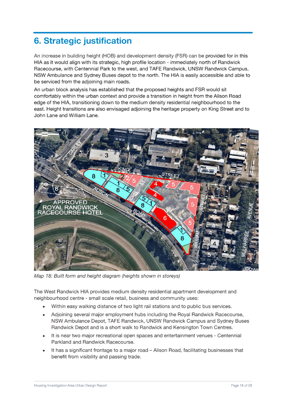
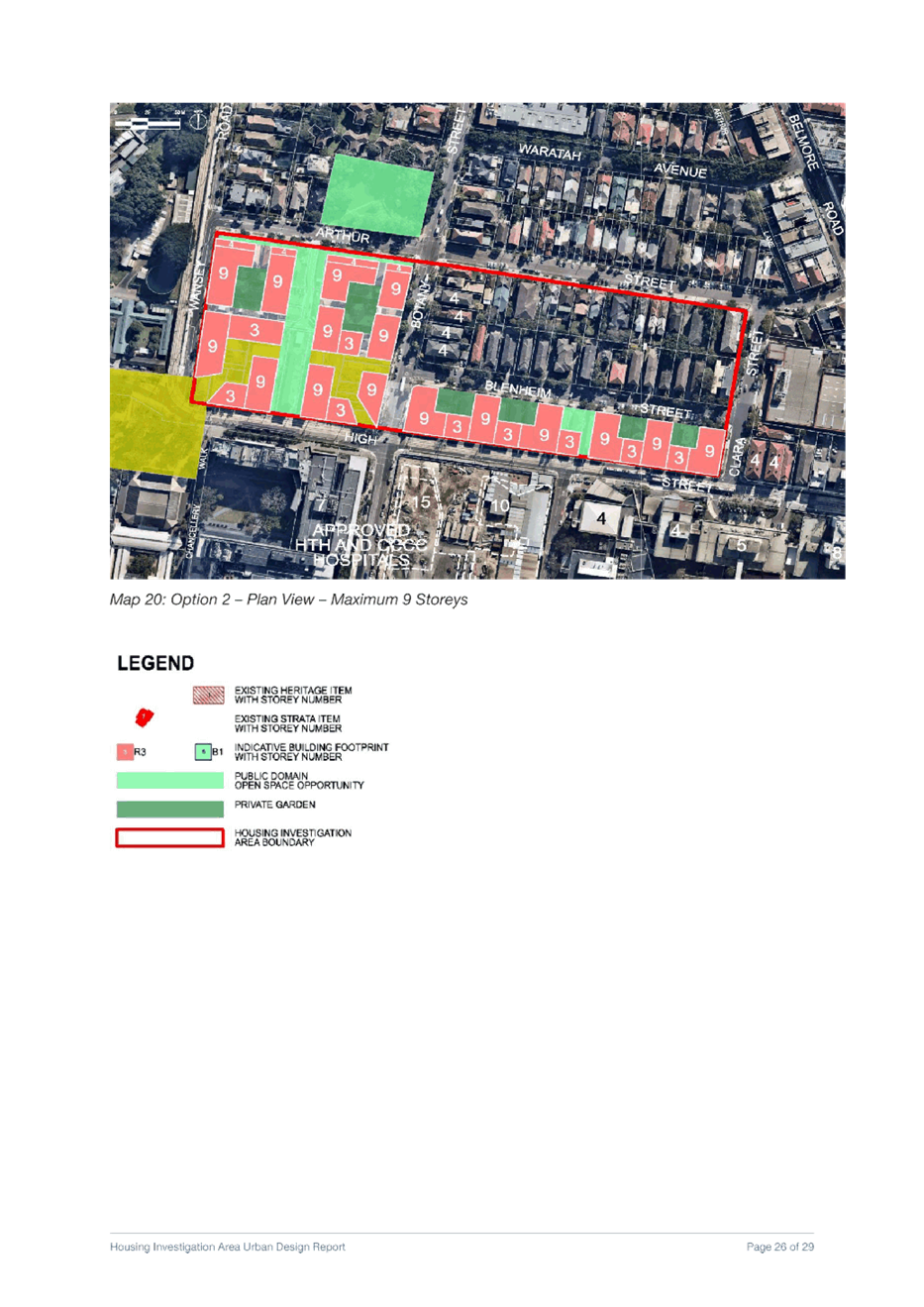
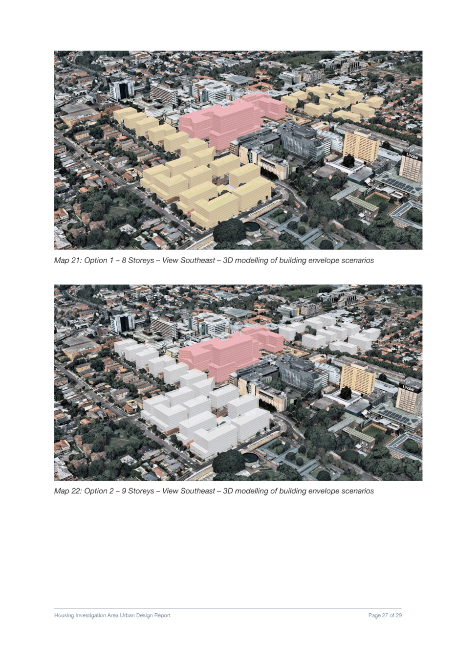
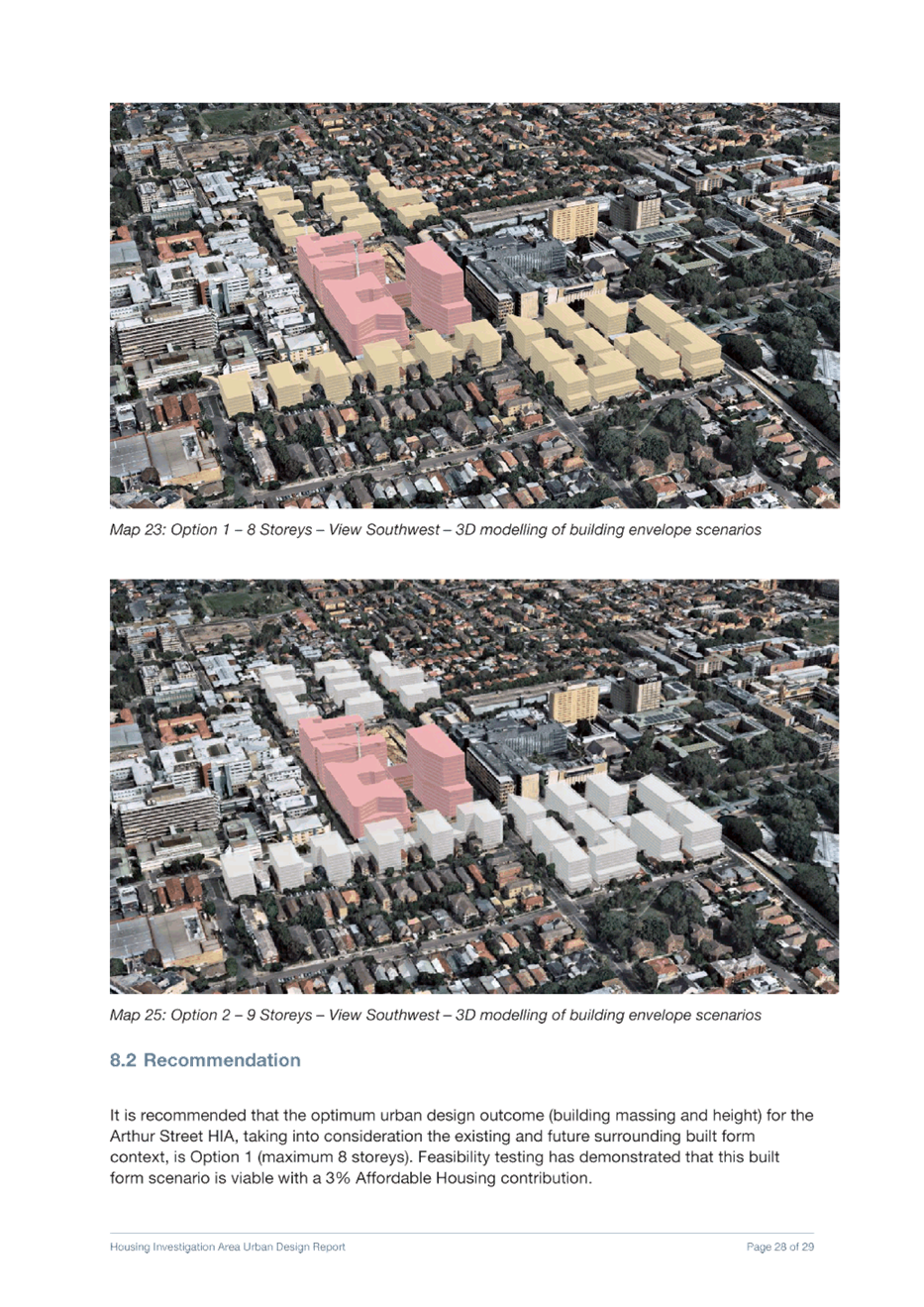
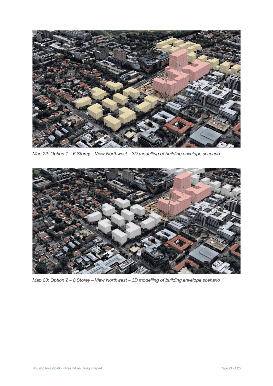
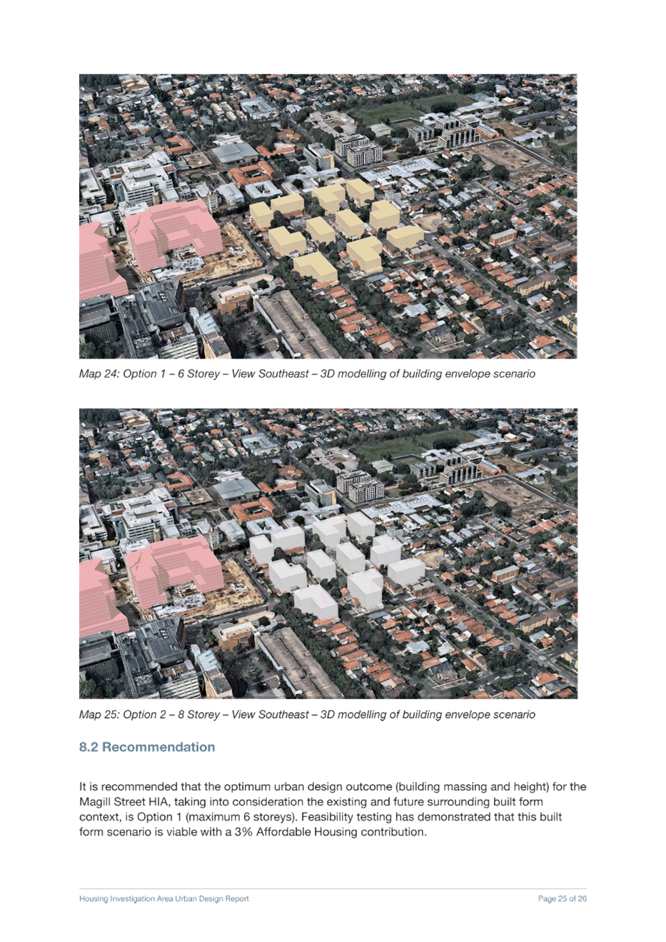
The proposed new building heights have been considered in relation to the context. The cross-sectional proportion of adjoining streets and the scale transitions to adjoining building interfaces and heritage buildings has informed the urban design of the HIA precincts. Taller buildings are generally considered appropriate along major vehicular and public transport thoroughfares such as Anzac Parade or Alison Road. The two HIAs that adjoin the UNSW and Randwick Hospital Campuses (Arthur Street HIA and Magill Street HIA) play an important role in providing a transition in building height from the proposed Randwick Hospital Expansion buildings (between 10 and 15 storeys in height) down to lower height residential areas to the south and north of the HIAs.
Similarly, the North Kensington HIA provides the transition in height from Kensington Town Centre (maximum 9 storey building height) down to lower scale residential precincts to the west and east, and to the extensive parkland (Centennial Park, Moore Park Golf Course and ES Marks Sports Field) to the north. The Kingsford South HIA provides a building height transition from the Kingsford Junction strategic node (maximum 17 storey building height with Design Excellence) down to the lower scale residential areas to the south.
Transitions in heights have been provided to adjacent lower density residential neighbourhoods or areas of no change, where appropriate. Setbacks to heritage items, open space or any other sensitive development within or adjacent to HIAs has been included in the built form modelling undertaken to date. Detailed design and built form controls will be finalised and included as part of the future comprehensive DCP.
The heights and FSRs derived from the urban design analysis have been tested by consultants Hill PDA for redevelopment feasibility and for their capacity to provide affordable housing through an affordable housing scheme.
Panel comment
The proposed controls rely on detailed controls in a future development control plan (DCP), which preferably should be exhibited alongside the new RLEP. If this is not possible, then the DCP should be finalised before gazettal of the new RLEP.
Council officers’ response
Council officers will continue to develop detailed controls for the inclusion in the future development control plan (DCP). These controls will be reported back to Council and subsequently exhibited for community feedback.
Panel comment
Consideration should be given to the new RLEP including standards in the Housing Investigation Areas in relation to minimum allotment size, minimum frontage, incentives for consolidation and affordable housing, possibly beyond the proposed 3%.
Council officers’ response
A detailed analysis of the proposed heights, floor space ratios and affordable housing contributions has been undertaken as part of Council’s place-based planning for the HIAs.
Affordable housing is addressed in the following section and also responds the Council resolution to seek an increase in the affordable housing contribution in the HIA areas. Council also requested at this meeting that a revised report be prepared containing lower building heights and densities.
In regard to new standards for minimum allotment sizes for residential flat buildings and shop-top housing, minimum frontages and incentives for consolidation, Council will be applying an approach consistent with other new development areas such as the Kensington and Kingsford (K2K) town centres. As such a minimum 20m frontage is appropriate for new development in the HIAs, consistent with existing requirements in Part 6 Lot Amalgamation in the K2K DCP. This provides suitable width for designing building layout including vehicular access, setbacks and landscaping.
The proposed heights and FSRs for the HIAs are the maximums for new development and have been identified through Council’s urban design analysis of these areas. Incentives for site amalgamation or minimum allotment size are not appropriate in the LEP as this would result in built forms beyond what is envisaged for the area and considered contextually suitable.
It is anticipated that amalgamation will occur in the HIAs to facilitate new development that is compliant with the proposed development standards (height and FSR) and the Apartment Design Guide. As such, site amalgamation requirements will be encouraged through future amendments to the DCP in site-specific HIA chapters. The proposed DCP chapters will also consider minimum site frontages, setbacks, landscaped areas, site coverage and consideration of isolated sites (to discourage such outcome). In doing so, this will ensure that future development in the area is consistent with what is envisaged through Council’s site specific analysis of the HIAs and ensure that a consistent approach is used across Randwick City.
Panel comment
Further consideration should also be given to areas that are currently within the Housing Investigation Areas but propose no increase in density based upon market analysis as opposed to strategic merit.
Council officers’ response
The HIAs were selected as part of investigations in the preparation of the LSPS and Housing Strategy which were endorsed in February 2020. Council officers have undertaken extensive analysis of the HIAs since then, and have applied a place-based, design-led approach in selecting areas within the HIAs that are suitable for uplift and in recommending controls that will facilitate this uplift to meet Council’s 6-10 year housing target.
This analysis has demonstrated that some areas within the HIAs are less suitable for change given their characteristics and as such, have not been proposed for uplift. These areas have not been excluded based upon market analysis, but rather the contextual urban design analysis and the likelihood of redevelopment in the 6-10 year timeframe. Areas within the Magill Street and Kingsford South HIAs have not been proposed to change given their existing low density character. The land within the Kingsford South HIA where no change was proposed has been incorporated into the adjacent Diversity Area.
These areas may provide opportunities for long-term housing growth through subsequent investigations as part of a future LEP review. Council’s ability to meet its 6-10 year housing target is not dependent on any change in these areas. The 5 HIA Urban Design Analysis reports (Attachments 3-7) address any areas within the HIAs where no change is proposed and provide the rationale to support the approach to change in these areas.
2. Affordable Housing Contributions
As stated, Council requested a revised report containing revised down building heights and densities in the HIAs and an increased affordable housing contribution in the identified HIAs.
This section addresses the relationship between building heights, viability of development and affordable housing contributions. It outlines the potential affordable housing yield which could be achieved by applying a 3% or 5% contribution scheme within the HIAs.
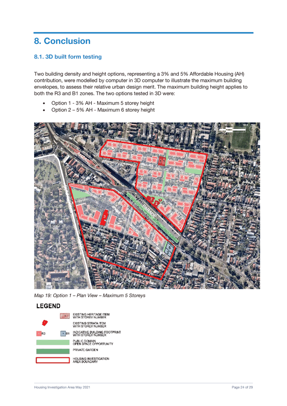
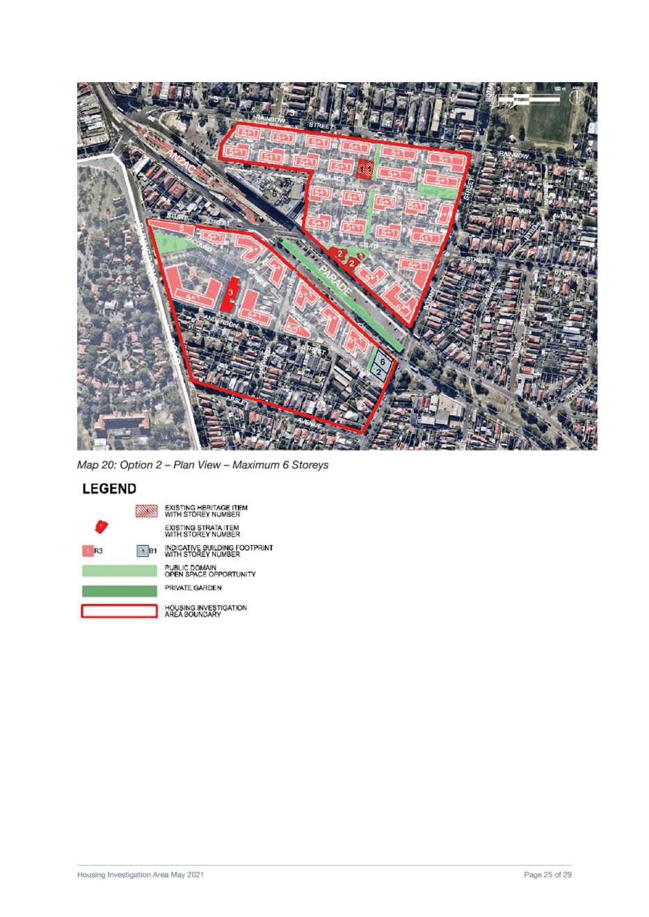
Affordable housing contributions and building densities are inextricably linked. Revising down the heights and FSRs in the HIAs will result in development that is not feasible, regardless of the affordable housing contribution. An increase the affordable housing contribution from 3% to 5% is only viable in Kensington North and in the small R3 area of West Randwick without the need to increase the recommended heights and FSRs. In relation to the other areas, an additional one or two storeys would be required to achieve viability with a 5% affordable housing contribution.
Council’s endorsed LSPS and Housing Strategy sets a 10% social and
affordable housing target, requiring 10% of all dwellings in the City to be
social and/or affordable by 2036. To achieve this target, Council’s LSPS
and Housing Strategy includes an action to investigate an affordable housing
contributions scheme to apply in areas of housing growth and/or major
redevelopment sites, such as the HIAs.
As demonstrated in the HillPDA report, the FSRs required to facilitate viable development are generally the same with a 0% affordable housing contribution and a 3% affordable housing contribution. The 3% contribution can generally be absorbed by developers as part of their overall development feasibility.
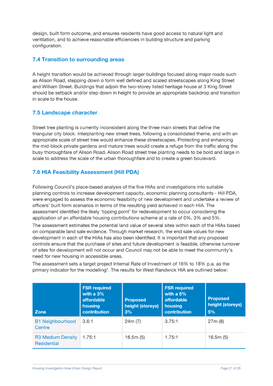
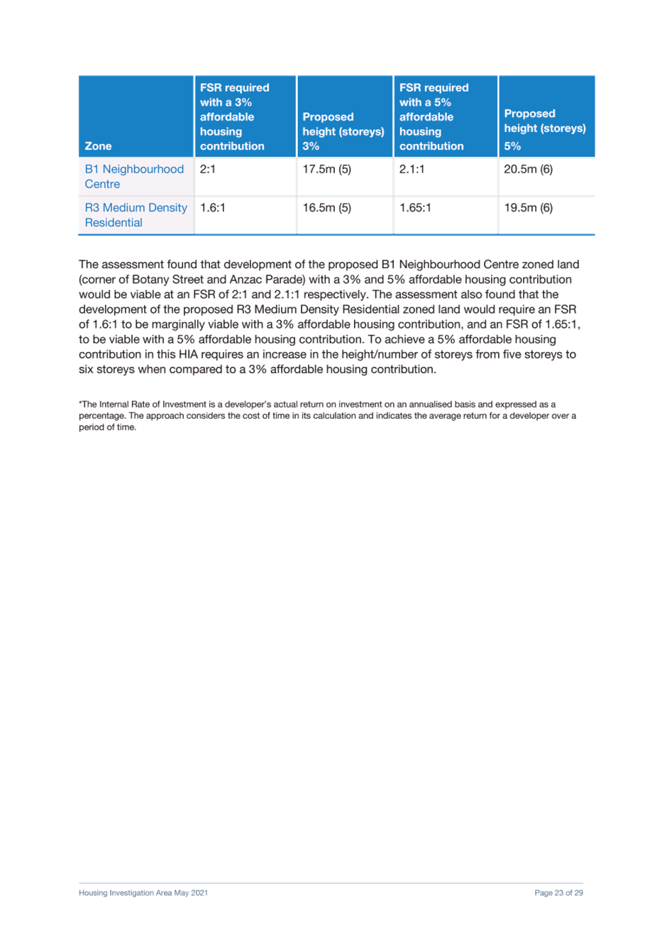
However, if a 5% affordable housing contribution is required, the FSRs required to facilitate viable development must increase. Council’s built form modelling of the 5 HIAs with the FSRs required for a 5% contribution found that this would generally require additional another 1-2 storeys to ensure that such FSRs can be achieved. The required increases in FSRs differ between the 5 HIAs given the varying conditions and land prices at each. It is noted that the HillPDA report is just a guide to inform Council’s analysis and that the FSRs proposed in the previous report were tested by officers through built form modelling, considering these various features and constraints in each HIA. The following table demonstrates the FSRs and heights required to enable a viable development applying a 3% and 5% contribution:
Table 1: FSRs and heights required for a 3% and 5% affordable housing contribution
|
HIA |
Zone |
3% affordable housing contribution (recommended March 2021) |
5% affordable housing contribution |
||
|
|
|
FSR |
Height in storeys |
FSR |
Height in storeys |
|
West Randwick |
B1 |
3.6:1 |
7 |
3:75 |
8 (+1 storey) |
|
R3 |
1.5:1 |
5 |
1.5:1 |
5 (+0) |
|
|
Kensington North |
R3 |
2:1 |
7 |
2:1 |
7 (+0) |
|
R3 |
1.5:1 |
5 |
1.5:1 |
5 (+0) |
|
|
Arthur Street |
R3 |
3:1 |
8 |
3.25:1 |
9 (+1) |
|
Magill Street |
R3 |
1.8:1 |
6 |
2.5:1 |
8 (+2) |
|
Kingsford South |
R3 |
1.6:1 |
5 |
1.65:1 |
6 (+1) |
|
B1 |
1.7:1 |
5 |
2:1 |
6 (+1) |
|
Note: Highlight indicates areas where a 5% affordable housing contribution is viable without increasing heights and FSRs
West Randwick HIA:
· The analysis found that FSRs in the B1 zone (along Alison Road) would have to increase from 3.6:1 to 3.75:1 FSR to remain viable with a 5% affordable housing contribution. Council officers’ built form modelling found that this would require an additional storey (7 to 8 storeys)
· 5 storey development in the R3 zone at an FSR of 1.5:1 would be viable with a 5% affordable housing contribution
Kensington North HIA:
· The analysis found that 7 storey development with an FSR of 2:1 would be marginally viable with a 5% affordable housing contribution in this HIA.
· 5 storey development in the R3 zone at an FSR of 1.5:1 would be viable with a 5% affordable housing contribution.
Arthur Street HIA:
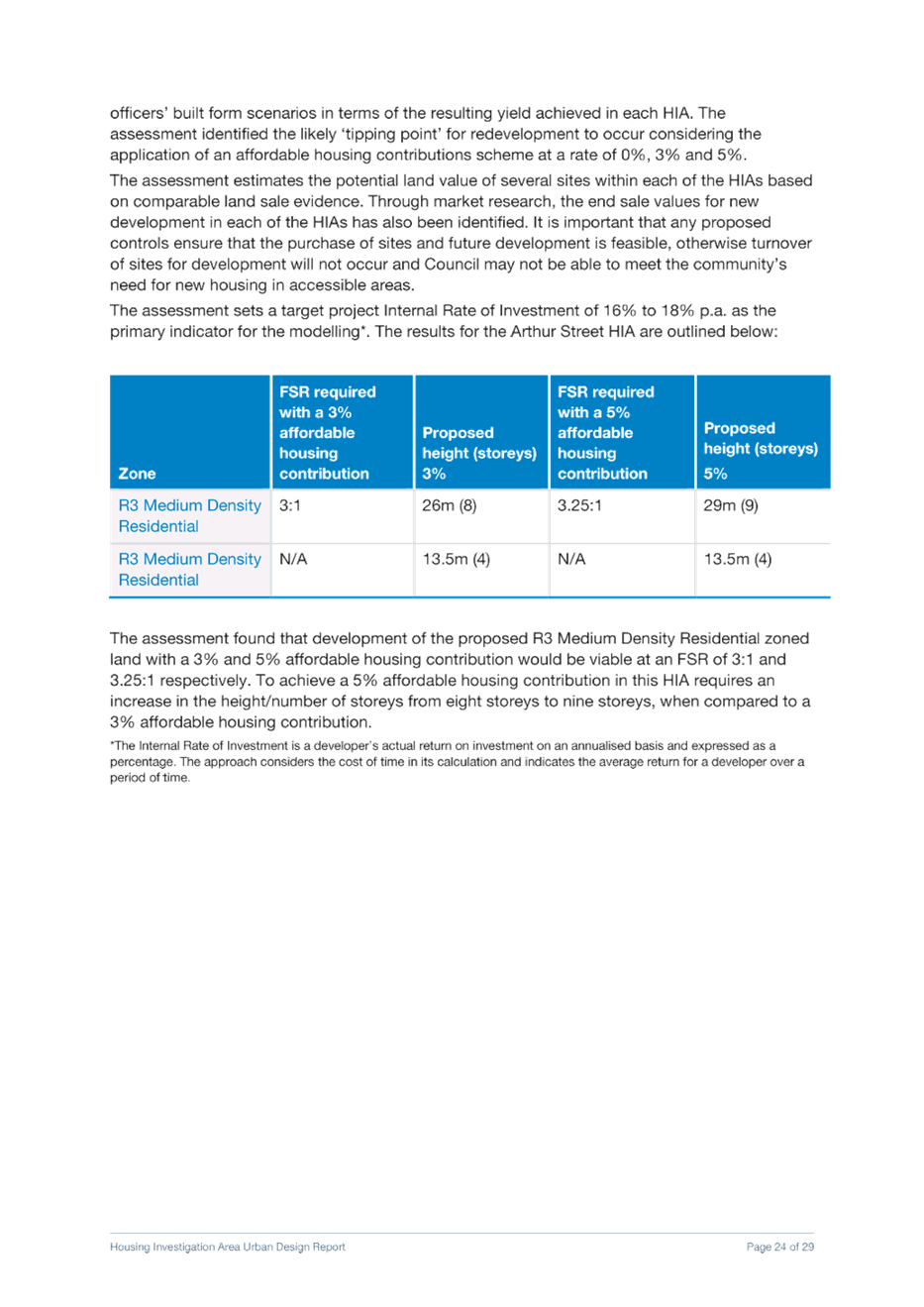
· The analysis demonstrates that FSRs in this HIA would have to increase from 3:1 to 3.25:1 to remain viable with a 5% affordable housing contribution. Council officers’ built form modelling found that this would require an additional storey (8 to 9 storeys).
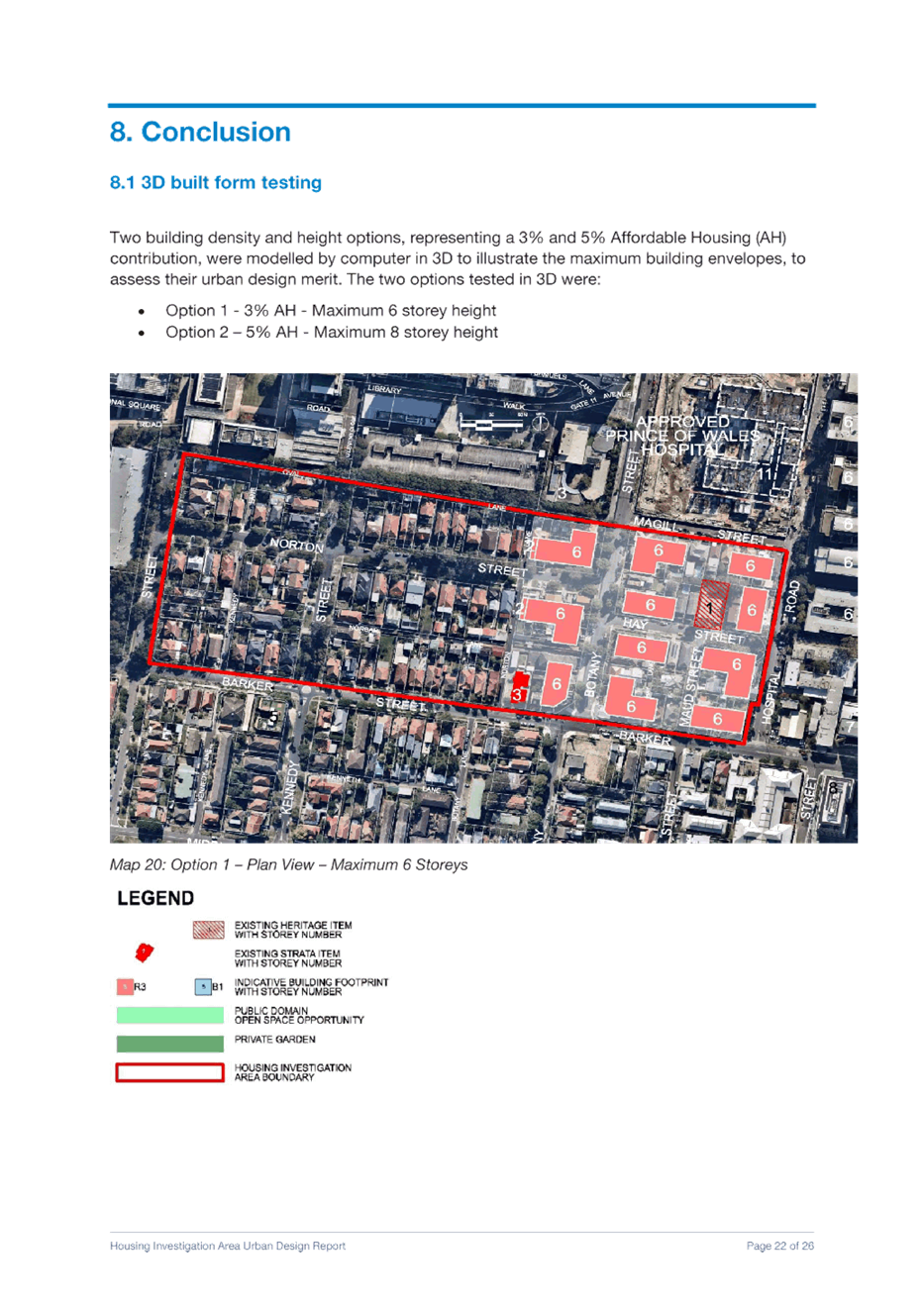
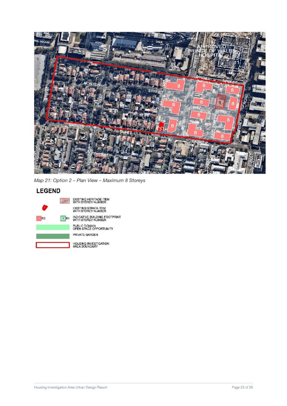
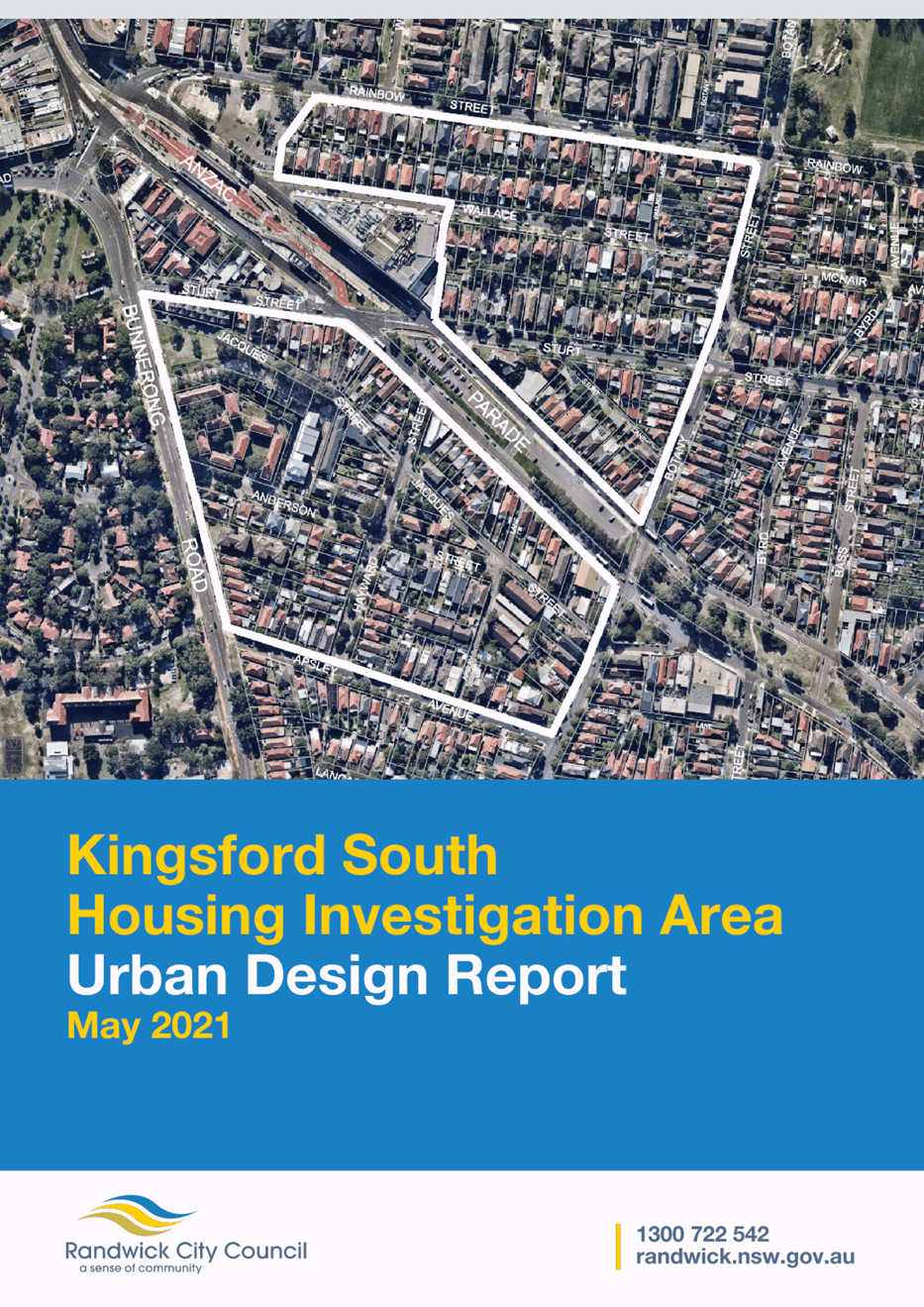
Magill Street HIA:
· The analysis demonstrates that FSRs in this HIA would have to increase from 1.8:1 to 2.5:1 to remain viable with a 5% affordable housing contribution. Council officers’ built form modelling found that this would require an additional two storeys (6 to 8 storeys).
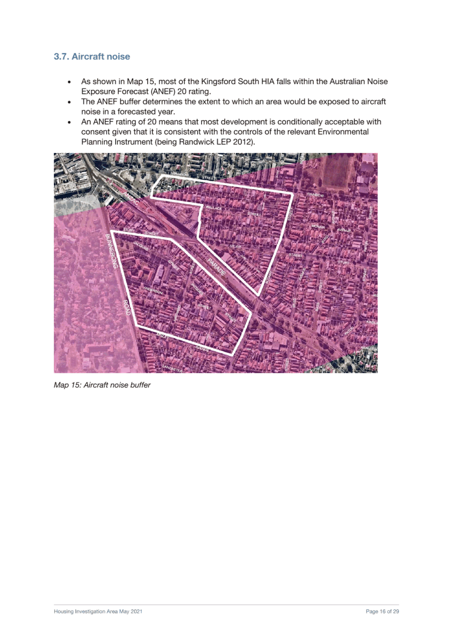
Kingsford South HIA:
· The analysis demonstrates that FSRs in this HIA would have to increase from 1.6:1 to 1.65:1 in the R3 and 1.7:1 to 2:1 in the B1 zone to remain viable with a 5% affordable housing contribution. Council officers’ built form modelling found that this would require an additional storey (5 to 6 storeys).
Affordable housing yield
As demonstrated above and in the HillPDA report, increasing the affordable housing contributions in the HIAs while decreasing densities (FSRs and heights) does not provide financially feasible redevelopment. Based on this, it is Council officers’ recommendation to apply a 5% affordable housing contribution in the R3 area of West Randwick HIA and across the Kensington North HIA and maintain the 3% affordable housing contribution in the remaining HIAs. This recommendation is the maximum affordable housing that can be achieved without any increase in FSRs and heights, noting the Council resolution seeks to increase affordable housing and reduce densities in the HIAs.
The following table shows the potential affordable housing yield when applying a 3%, a mix of 3% and 5% (recommended) and 5% to all HIAs:
Table 2: Potential affordable housing yield options
|
|
Contribution to 6-10 year housing target |
Affordable housing units (6-10 year) |
Affordable housing units (long term) |
Total affordable housing (by 2036) |
|
3% affordable housing – all HIAs (recommended in March 2021) |
~574 dwellings |
~17 dwellings |
~52 dwellings |
~69 dwellings |
|
Mix of 3% and 5% affordable housing (currently recommended) |
~574 dwellings (+0 dwellings from the 3% AH option) |
~20 dwellings (+3 dwellings) |
~59 dwellings (+7 dwellings) |
~79 dwellings (+10 dwellings) |
|
5% affordable housing – all HIAs (possible only with increased FSRs and heights) |
~632 dwellings (+58 dwellings) |
~32 dwellings (+15 dwellings) |
~95 dwellings (+43 dwellings) |
~127 dwellings (+58 dwellings) |
The 3% affordable housing option could generate ~17 affordable housing units in the 6-10 year timeframe and ~52 in the longer term (10-20 years), considering the take-up rates applied to each of the HIAs (40-50%). This could provide a total of ~69 affordable housing dwellings in total by 2036.
The 5% affordable housing option could generate ~32 dwellings in the 6-10 timeframe and ~95 in the longer term. This could provide for ~127 dwellings in total by 2036. The FSRs required for feasible development with a 5% affordable housing contribution would result in ~632 dwellings toward the 6-10 year timeframe. This is an increase in ~58 dwellings, or 10.1% in comparison with the 3% option. When applying the 5% affordable housing contribution, the amount of affordable housing which could be delivered increases by over 80% (from 52 to 95 dwellings). This option would provide significant community benefit by increasing affordable housing in accessible areas to meet local demand. The trade-off with this option is the increase in FSRs and height required, which would generally result in an increase of 1-2 storeys compared to the 3% option proposed in March 2021. Given the concern regarding the densities proposed in the HIAs, although this option would yield significantly more affordable housing, the recommended option will not result in any increase in FSRs and heights.
The recommended option (5% affordable housing contribution in Kensington North HIA and part of the West Randwick HIA, with 3% in the remaining HIAs) takes into account the potential concerns regarding the heights and densities proposed in the HIAs and aims to provide the maximum affordable housing yield (i.e. ~79 affordable housing dwellings by 2036).
The recommended affordable housing contribution for each HIA is shown below. Note that no changes to the heights and FSRs are proposed since the last report. Instead, it is proposed to increase the affordable housing contribution scheme in areas where it is feasible, being the Kensington North HIA and part of the West Randwick HIA (zoned R3). Based on Council’s analysis, this approach would generate ~20 dwellings in the 6-10 year timeframe and ~59 dwellings in the long term. In total, this would result in ~79 dwellings which is an increase of ~10 dwellings or 14% based on the previously recommended 3% option.
Table 3: Recommended affordable housing contribution for each HIA
|
Housing Investigation Area (HIA) |
Proposed affordable housing contribution levy |
|
West Randwick |
3% - B1 zone |
|
5% - R3 zone |
|
|
Kensington North |
5% |
|
Arthur Street |
3% |
|
Magill Street |
3% |
|
Kingsford South |
3% |
Other options for consideration
Should Council resolve not to proceed or modify any of the Council officer recommendations, this would require the consideration of other options to provide housing capacity to meet our 6-10 year housing target. The HIAs would yield approximately 574 dwellings in the 6-10 year period. The following three options have been reviewed:
Increased densities in the R3 Medium Density Residential zone
As part of the preparation of the Randwick Housing Strategy, Council engaged consultants to undertake a Randwick housing capacity study. This study analysed opportunities within the R3 Medium Density zone and found that this zone has a potential total capacity (lots that can be redeveloped) of between 5,317 to 12,820 sites (after excluding constraints such as heritage, strata lots and recent developments). These sites have the potential to exceed the total 6-10 year housing targets for Randwick City.
The capacity report also found that development in most areas of the R3 Medium Density zone is generally unfeasible under existing FSR controls (i.e. 0.75:1 or 0.9:1). FSRs would need to increase beyond 1.5:1 for development to be feasible in these areas. Based on this substantial FSR increase, this would result in increased heights of 2-3 storeys (from 3-4 storeys to 5-6 storeys) across the R3 Zone. Whilst spreading housing growth over a larger area may provide an alternative approach, the implications for this option include:
· Some development being located in less accessible areas
· More housing yield than required to meet the targets
· Inconsistent with the place-based approach to selecting areas as outlined in the Housing Strategy
Reduce minimum lot size for dual occupancies to 450sqm
Another approach to deliver housing is to reduce the minimum lot size from the recommended 550m2 to 450m2. This would result in a total yield of 2,141 dwellings by 2036 and contribute to 714 dwellings to the 2021-2026 targets. By comparison, the previous (March 2021) recommendation for 550m2 minimum lots can provide 1,423 dwellings by 2036 and contribute to 474 dwellings to the 2021-2026 targets. This would provide an increase of approximately 50% compared to the previously endorsed minimum lot size of 550m2.
As outlined in the previous report the minimum 550m2 lot size was selected as it can provide for good levels of landscaped area, tree canopy cover, deep soil and permeable surfaces on a development site. It is also consistent with the approach of balanced growth across Randwick City and good design outcomes.
Randwick Junction Planning Strategy
At the Council Meeting on 27 April 2021, Council considered a Planning Strategy for the Randwick Junction Town Centre and resolved as follows:
a) defer the Randwick Junction Strategy and report back to Council on the findings of further feasibility analysis and fine grain urban design modelling against heritage values;
b) agree to incorporate the following heritage items in the draft Randwick Comprehensive Planning Proposal:
i. 1 Belmore Road,167-171 Alison Road and 179-181 Alison Road, Randwick and
ii. extend the curtilage of the heritage item at No 60 Belmore Road to include the adjoining address known as 25 Waratah Avenue Randwick.
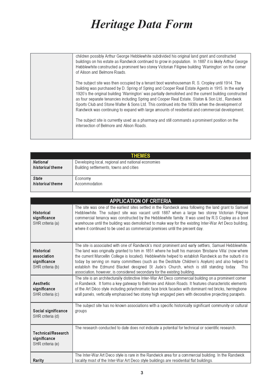
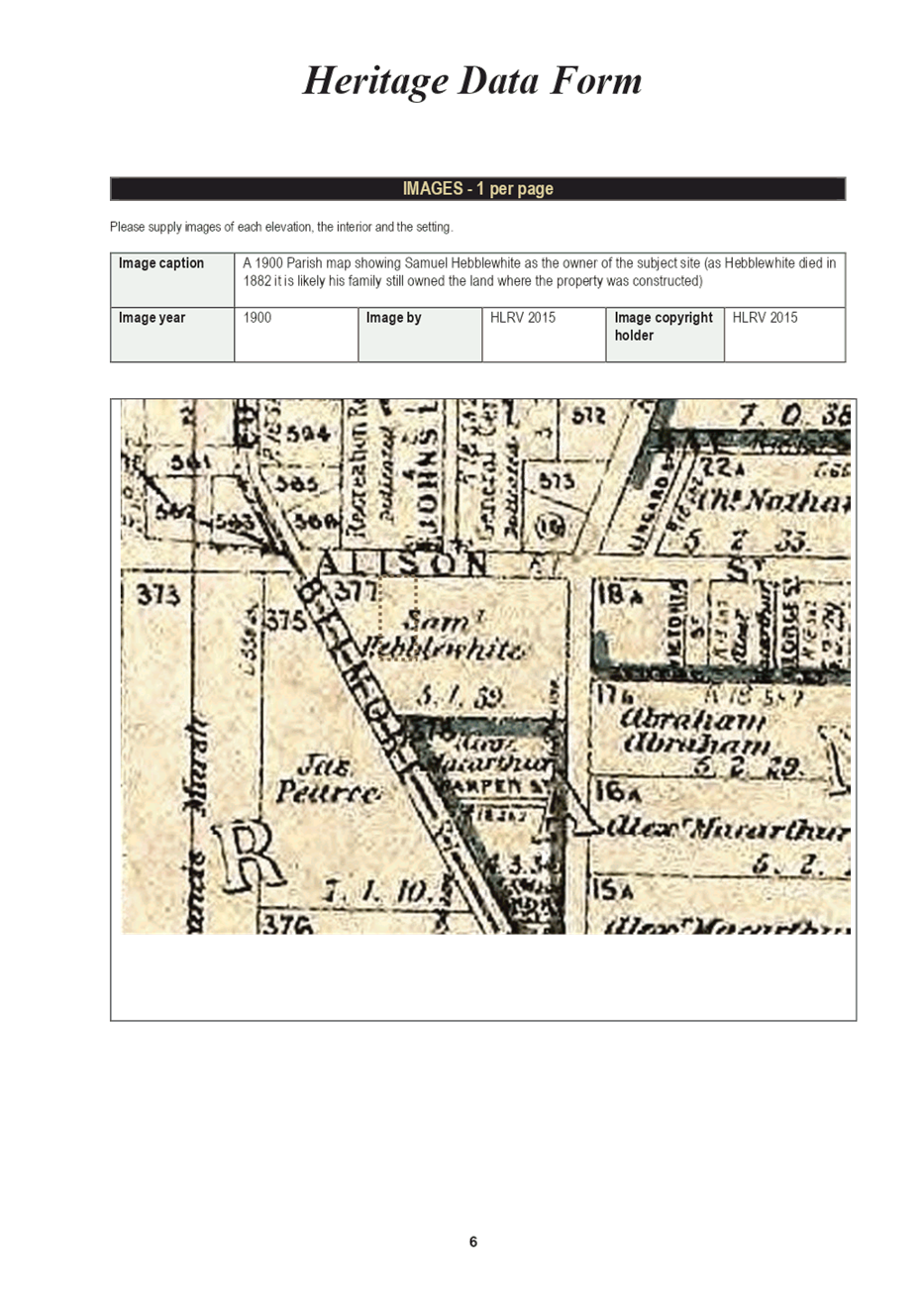
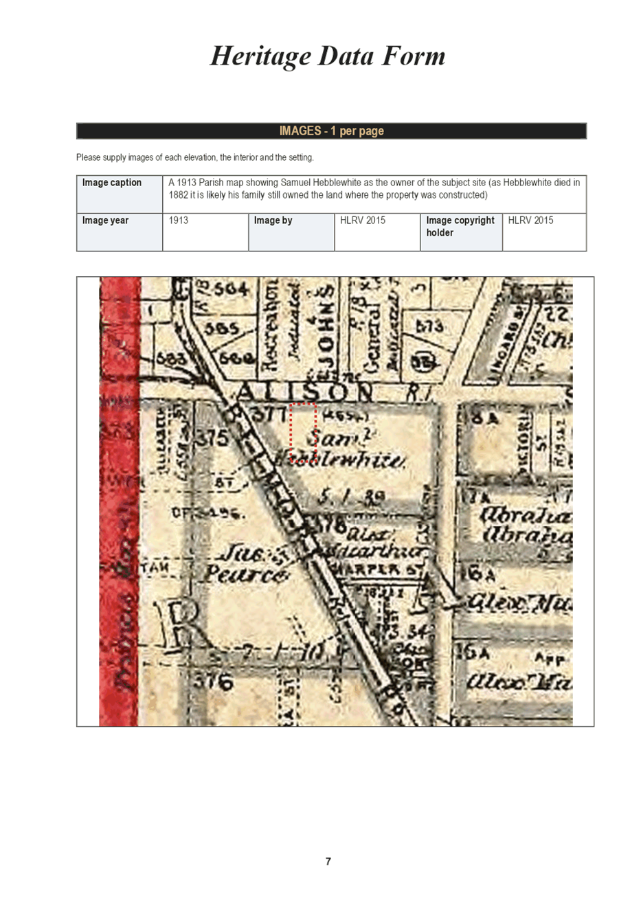
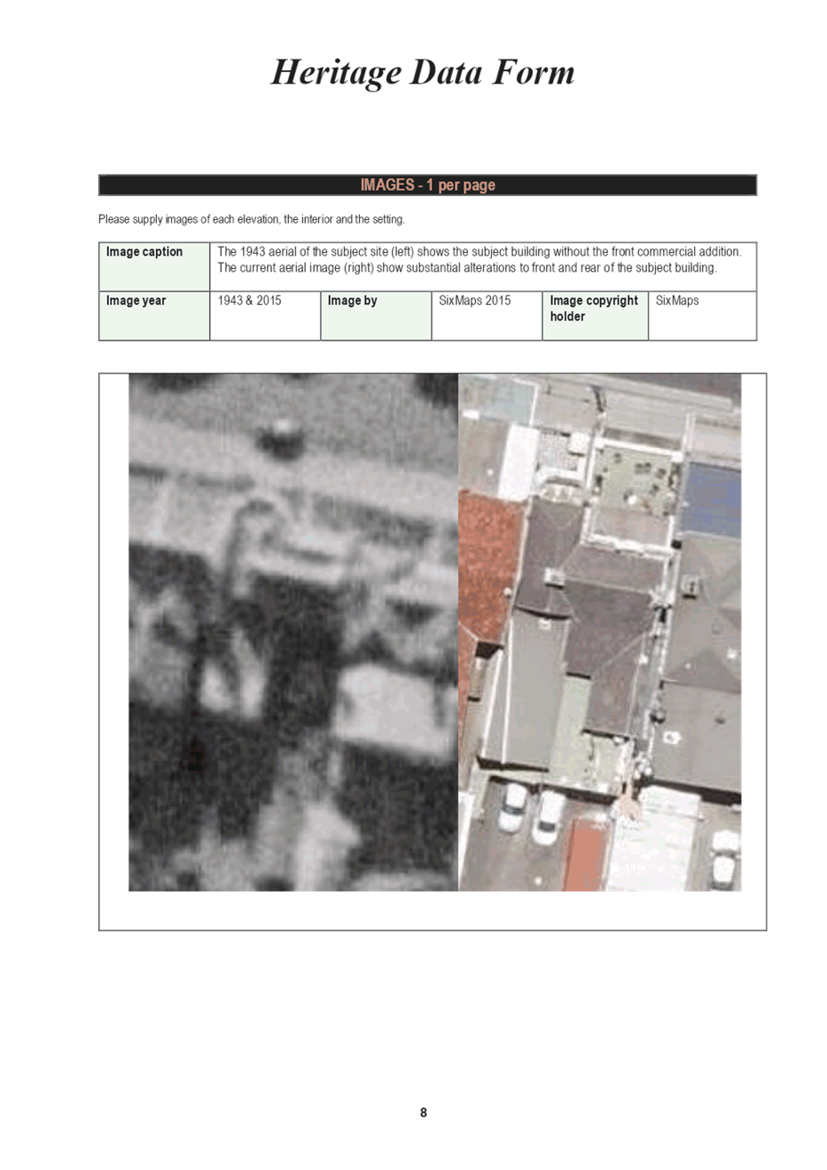
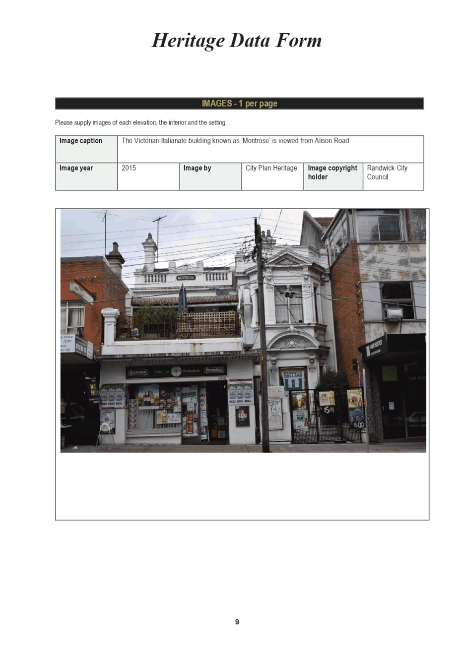
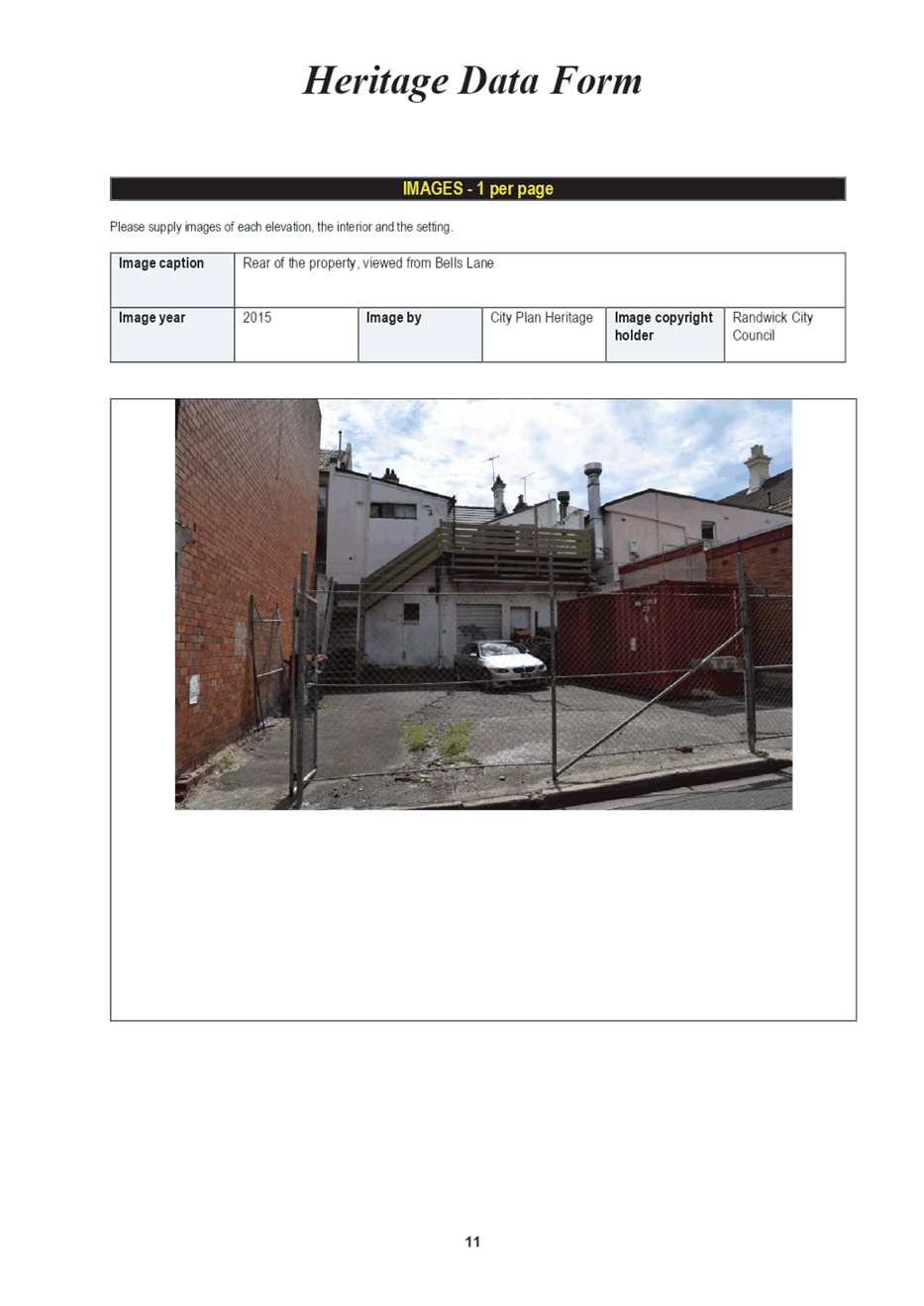
The proposed heritage items listed in the above resolution were identified in a heritage study (The Randwick Junction Town Centre Heritage Review 2015 by City Plan Heritage Pty Ltd)
which formed part of a number of studies underlying the RJ Strategy. The heritage data sheets for these items are provided in Attachment 9. As the Randwick Junction town centre falls wholly within the Randwick Junction Heritage Conservation Area (HCA), Council commissioned City Plan Services to re-evaluate the status and condition of existing heritage items and contributory buildings, as well as the boundaries of the heritage conservation area and making recommendations for any required adjustments. The Review included background research and review of individual buildings, and updated Heritage Inventory Sheets for each heritage item.
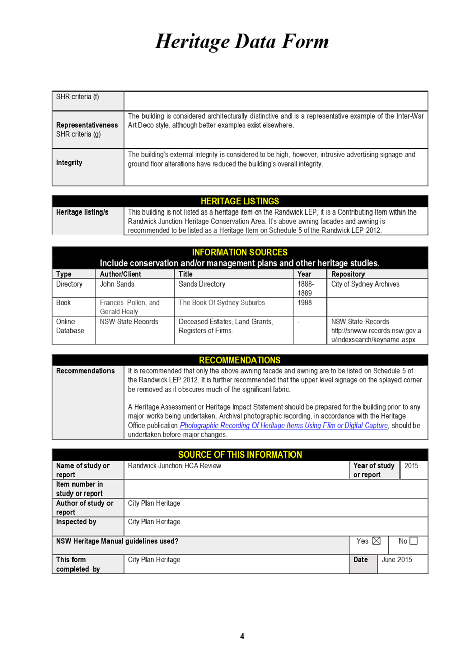
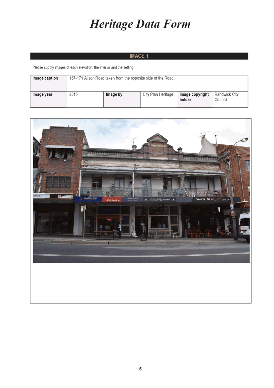
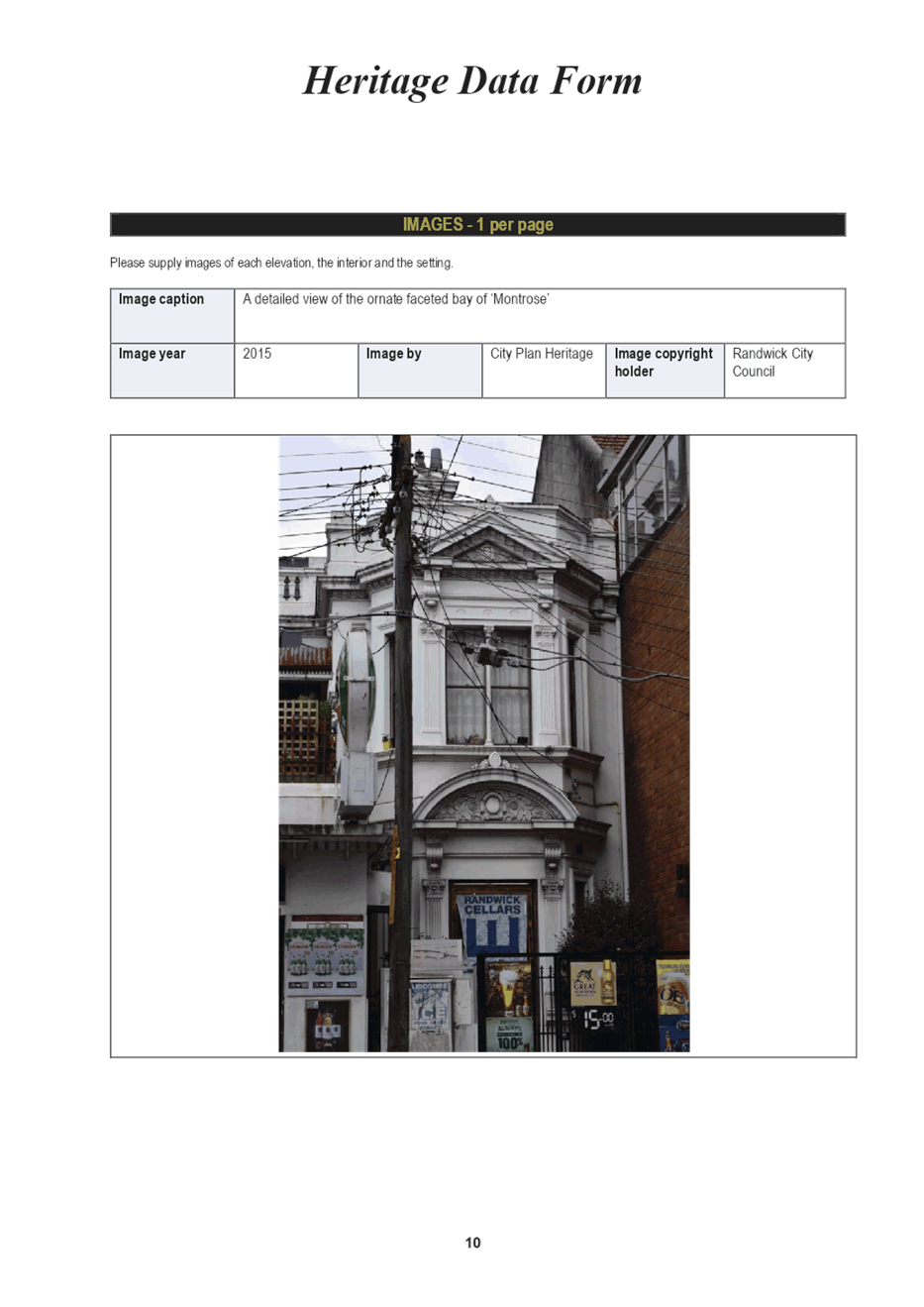
Under the Review, three (3) potential Heritage Items were recommended for listing (Nos. 1 Belmore Road,167-171 Alison Road and 179-181 Alison Road). As reflected in the table below, the Review recognised the three proposed items as being representative of the mixed Victorian and Interwar periods of the Alison Road frontage and streetscape of Randwick Junction. This gives this Alison Road section of the town centre a special and significant character presenting as a two-storey traditional shop-strip with awnings and decorative stepped parapets and well-articulated facades.
Additionally, the Review recommended that the curtilage of one Heritage Item (No 48-60 Belmore Road) be expanded to include the adjoining property at 25 Waratah Avenue Randwick. The Review states that the existing heritage item at No 48-60 Belmore Road is an Inter-War Art Deco residential and commercial building that has a significant frontage along Belmore Road (see Table below). It extends from Waratah Avenue and spans half the length of the Belmore Road block from Waratah Avenue to Silver Street. Adjoining the heritage item to the west is a separate Inter-War Art Deco building of the same era and design at No 25 Waratah Avenue. To reinforce heritage character and significance, the Review recommends that the curtilage of Heritage Item at No 48-60 Belmore Road be extended to include the full extent of the property at No. 25 Waratah Avenue.
In line with the heritage assessment contained in the Review, it is recommended that the following properties in Randwick Junction be incorporated as heritage items into the draft Randwick Comprehensive Planning Proposal:
· No. 1 Belmore Road, No.167-171 Alison Road and No. 179-181 Alison Road, Randwick
· Extend the curtilage of the heritage item at No 60 Belmore Road to include the adjoining property at No. 25 Waratah Avenue, Randwick.
Housekeeping amendments
The comprehensive Planning Proposal will also include amendments to Randwick Local Environmental Plan 2012 (RLEP) to address a number of housekeeping matters that have been identified during the operation of the instrument. The proposed amendments outlined primarily seek to address misdescriptions, anomalies and typographical errors in the written RLEP 2012 instrument and maps. The Panel’s advice is sought in regard to the following matters:
· Amendments to a number of property descriptors under Schedule 5 – Environmental Heritage
· Adjustments to boundaries of a number of heritage items and heritage conservation areas to ensure consistency with State Heritage Mapping, reflect the extent of curtilage and/or the subdivision of sites
· Deletion to a number of properties from Schedule 5 and the heritage maps as a result of approved demolition/redevelopment
· Rationalising the zoning of properties to rectify split zoning anomalies and reflect property boundary adjustments
· Amending Schedule 2 (special events and temporary use of land) of RLEP to ensure clarity in the application and interpretation of provisions
The proposed amendments are consistent with the planning priorities and actions of the Eastern City District Plan, the Randwick City Plan and the Randwick City Local Strategic Planning Statement in that it would result in improvements to the operation, clarity and communication of the RLEP 2012 in terms of intended zoning and application of planning controls.
· To address misdescriptions, errors, omissions, anomalies and inconsistences in the written instrument and maps
· To clarify the description and extent of a number of heritage items and heritage conservation areas
· To improve the communication, clarity and application of the Plan
· To promote the orderly development of land and/or to ensure consistency with existing land uses and built form
· To clarify the description of exempt development provisions under Schedule 2 of the RLEP to promote clarity in its interpretation
Explanation of provisions
Heritage matters
A number of amendments are proposed to Schedule 5 - Environmental Heritage of the RLEP 2012 and/or the Heritage Map as described as follows:
Corrections to Item Names
The Randwick Environment Park and Henry Head Fortification Complex are incorrectly identified as “Randwick Environmental Park” and “Henry Fort Complex” respectively in Schedule 5 – Environmental Heritage of the RLEP.
It is proposed that the item descriptions for these properties be amended for the purposes of accuracy. The proposed amendments will not affect the property description (Lot/DP) nor require changes to the Heritage Maps.
Table 4: Proposed Corrections to Item Names
|
Inventory No |
Item/ Heritage Conservation Area |
Proposed Item Name |
|
C14 |
Randwick Environmental Park Heritage Conservation Area |
Randwick Environment Park Heritage Conservation Area |
|
1165 |
Henry Head Fort |
Henry Head Fortification Complex |
Corrections to Addresses
The four sites listed in Table 2 are situated in the former Prince Henry Hospital Site and listed as Heritage Items in Schedule 5 – Environmental Heritage of the RLEP 2012. The NSW Valuer General has requested that the addresses of these items be unified for rates/valuation purposes.
The proposed changes will not affect the property description (Lot/DP) in Schedule 5 of the RLEP 2012, nor would require changes to the Heritage Maps.
Table 5: Proposed Amendments to Item Addresses
|
Item Name |
Existing Property Description/Address |
Proposed Property Description/Address |
|
|
Former PHH- The Dam
|
5R Coast Hospital Rd, Little Bay |
1 Coast Hospital Rd, Little Bay |
|
|
I180 |
Former PHH- Former Male Lazaret site
|
5R Coast Hospital Rd, Little Bay |
1 Coast Hospital Rd, Little Bay |
|
I181 |
Former PHH- Former Coast Hospital Services Area retaining walls |
5R Coast Hospital Rd, Little Bay |
1 Coast Hospital Rd, Little Bay |
|
1177 |
Former PHH- Former Coast Hospital Water Tower |
7R Coast Hospital Rd, Little Bay |
1 Coast Hospital Rd, Little Bay |
Proposed Additions to Schedule 5 – Environmental Heritage and Maps
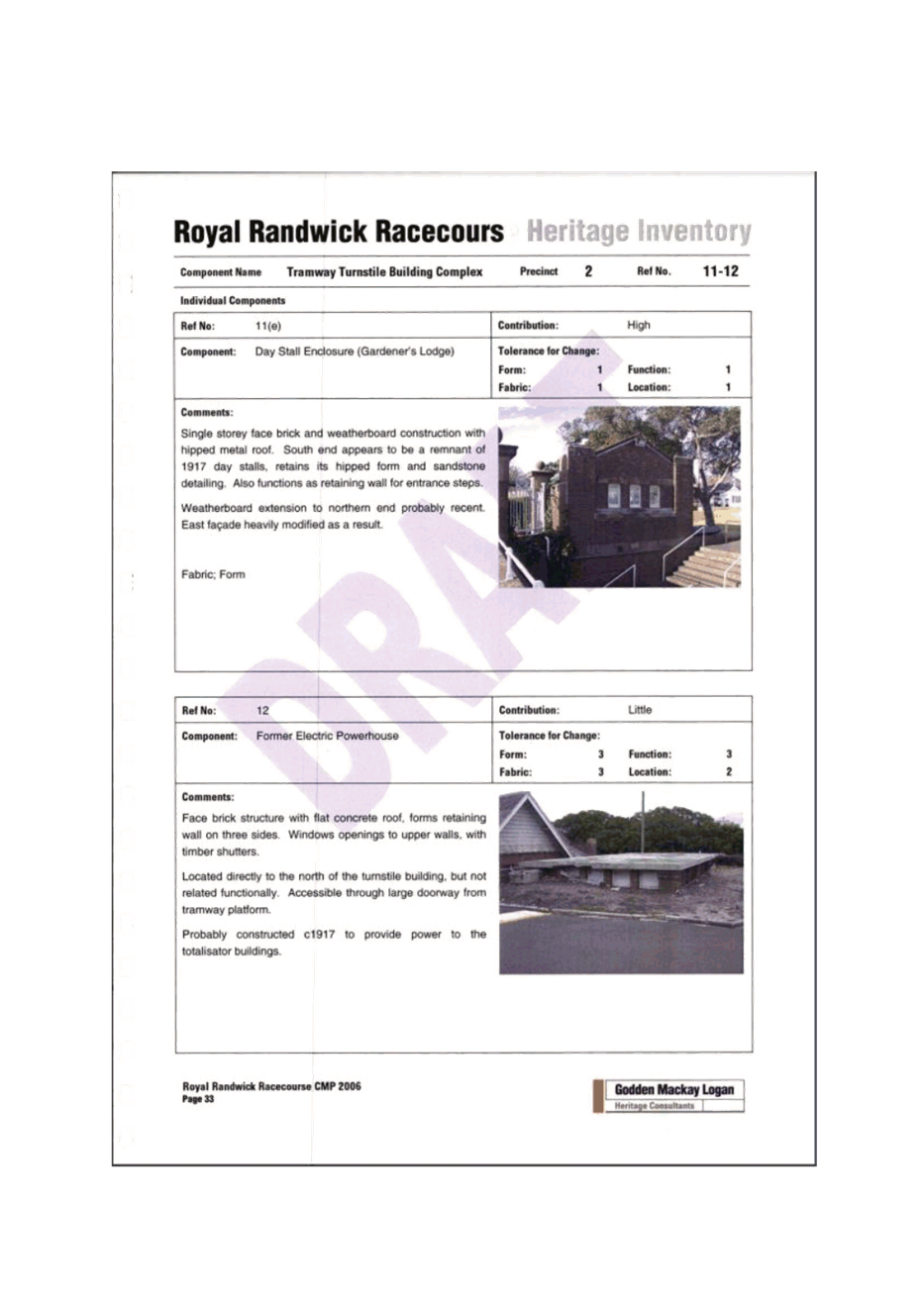
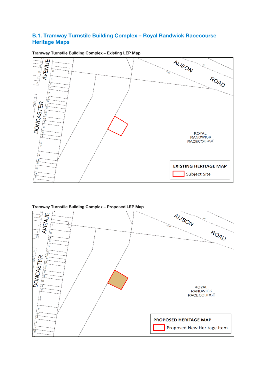
Tramway Turnstile Building Complex – Royal Randwick Racecourse
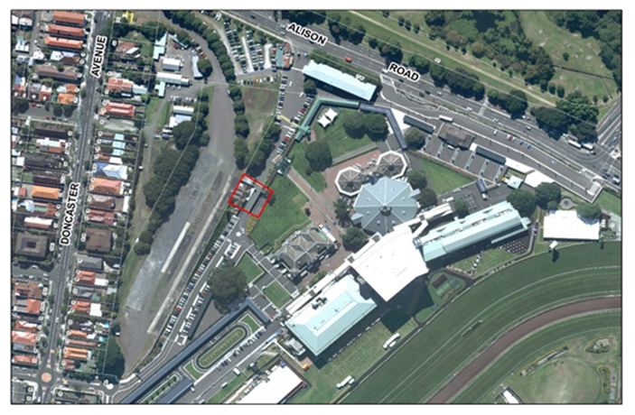
The Royal Randwick Racecourse Conservation Management Plan (prepared by Godden Mackay Logan Heritage Consultants in 2006) has identified the Royal Randwick Racecourse Tramway Turnstile Building Complex (Figure 1) as having exceptional social and aesthetic heritage significance as one of the only intact remnants of the tramway that carried spectators to the races.
Additionally, the Tramway Turnstile Building provides a rare example of an intact tramway facility retaining its contextual relationship between the racecourse and tram/busway.
It is proposed that the heritage significance of the building complex be recognised in the RLEP 2012 by:
· Adding the Tramway Turnstile Building Complex to Schedule 5- Environmental Heritage; and
· Amending the relevant Heritage Map as per Attachment 10
|
Figure 1: Tramway Turnstile Building Complex – Royal Randwick Racecourse |
|
|
Deletions to Schedule 5 – Environmental Heritage and Maps
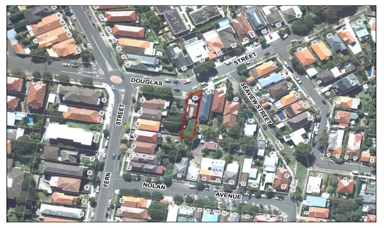
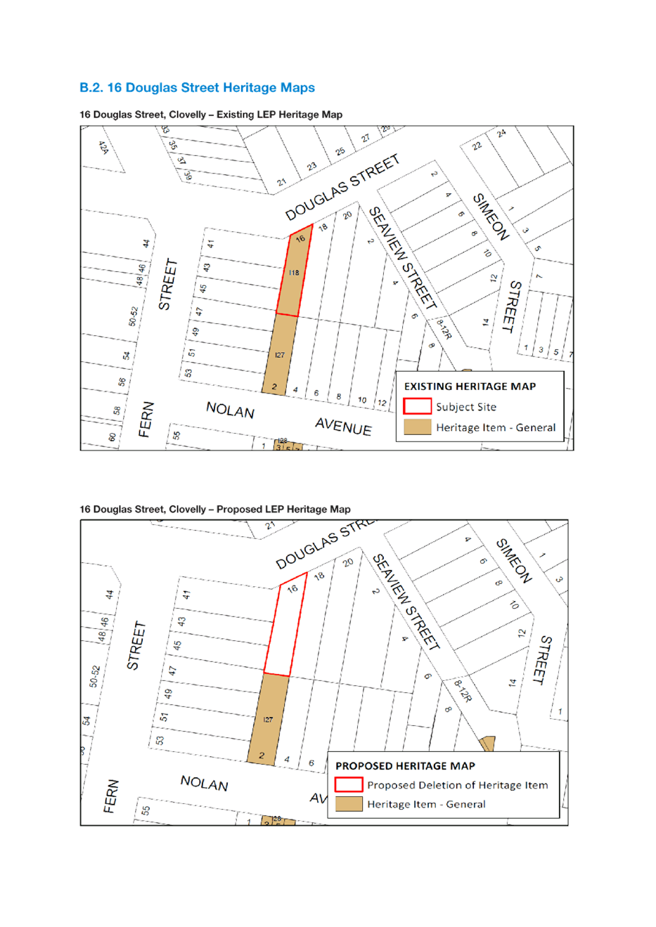
16 Douglas Street, Clovelly
The subject property (Lot 23, Section A, DP 1827) (Item I18) is listed as a heritage item in Schedule 5 of the RLEP 2012. In 2012 development consent (DA/146/2012) was granted for the demolition of the property given its state of dilapidation and poor structural condition at the time. A contemporary building has since been constructed on the site. The item thus does not warrant listing in Schedule 5 of the RLEP 2012. It is proposed that the RLEP 2012 be amended by:
· Deleting Item I18 from Schedule 5 – Environmental Heritage.
· Removing 16 Douglas Street as a Heritage Item from the Heritage Map as per Attachment 10
|
Figure 2: 16 Douglas Street, Clovelly |
|
|
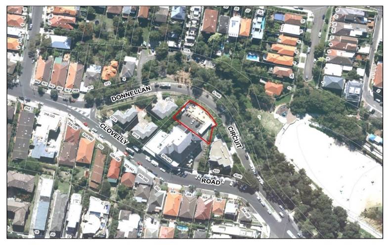
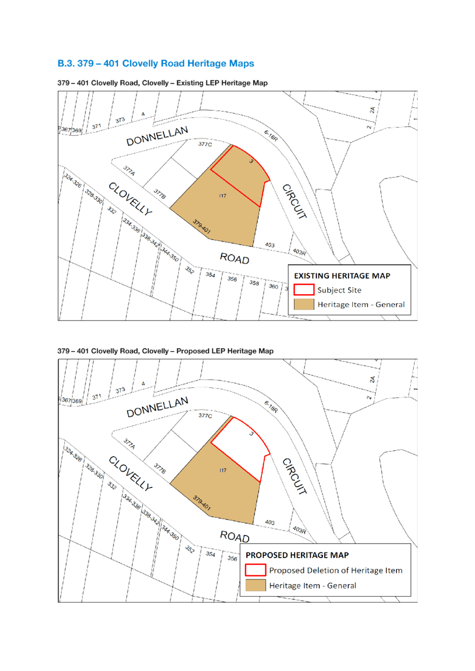
379 – 401 Clovelly Road, Clovelly
The Clovelly Hotel (Lot 1, DP 105854) is listed as a Heritage Item (Item I17) in Schedule 5 of the RLEP 2012. In 2012 development consent was granted for the subdivision of the site into two allotments to facilitate the construction of a new residential flat building (SC 19/2012) (DA 395/2009).
The resulting new allotment, (known as Lot 100 DP 1159761) (SP 84741) contains a contemporary building and therefore does not warrant heritage listing. It is proposed that Lot 100 DP 1159761 be removed from the RLEP 2012 Heritage Map as per Attachment 10. This amendment will not affect the heritage status of the Clovelly Hotel.
|
Figure 3: 379 – 401 Clovelly Road, Clovelly |
|
|
Heritage and Heritage Conservation Area Boundary Adjustments
A review of the RLEP 2012 Heritage Maps has identified minor discrepancies regarding the boundaries of a number of Heritage Items and Heritage Conservation Areas. Proposed amendments to the RLEP 2012 are outlined below.
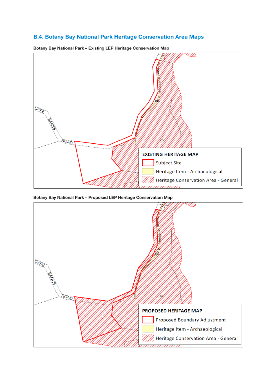
Botany Bay National Park Heritage Conservation Area
The boundary of the Botany Bay National Park Heritage Conservation Area does not correspond with the actual boundary of the Botany Bay National Park depicted on the State Heritage Map. To ensure that the extent of the site is accurately reflected on the RLEP 2012 Heritage Map it is proposed that the Heritage Conservation Area boundary be amended to align with the State Heritage Register Map. Proposed map changes are in Attachment 10.
|
Figure 4: Botany Bay National Park Heritage Conservation Area |
|
|
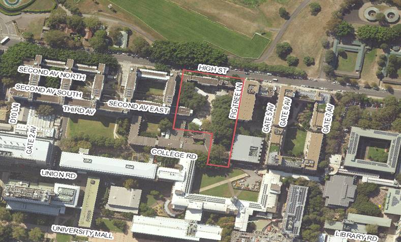
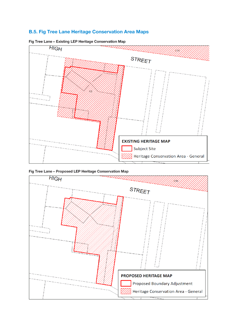
Fig Tree Lane Heritage Conservation Area
The Campus Living development is located within the Fig Tree Heritage Conservation Area. It is a contemporary building and does not warrant inclusion in the Heritage Conservation Area. It is proposed that the Heritage Conservation Area boundary be adjusted to remove the Campus Living development. Proposed map changes are in Attachment 10.
|
Figure 5: Existing Fig Tree Heritage Conservation Area |
|
|
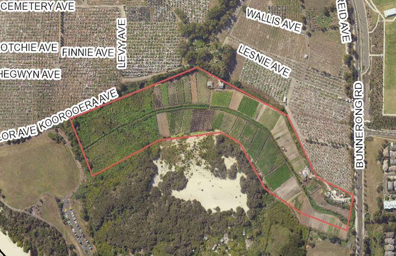
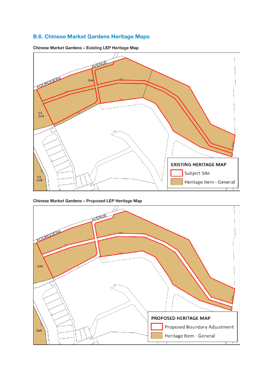
Chinese Market Gardens
The boundary of the Chinese Market Gardens site (known as Lots 1077–1079, DP 752015; Lot 5245, DP 820345) (I246) currently does not correspond with the site boundary depicted on the State Heritage Item Map.
To ensure that the extent of the site is accurately reflected on the RLEP Heritage Map it is proposed that the boundary of the site be amended consistent with the State Heritage Item Map. Proposed map changes are in Attachment 10.
|
Figure 6: Chinese Market Gardens |
|
|
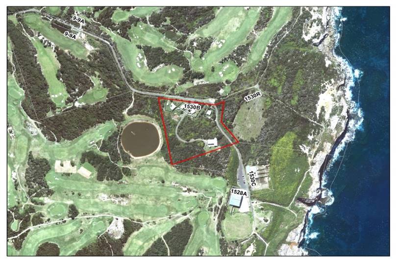
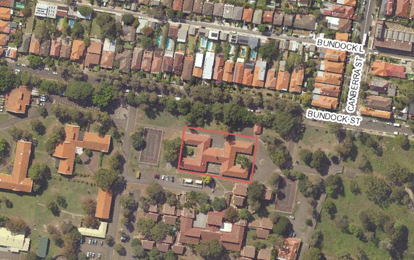
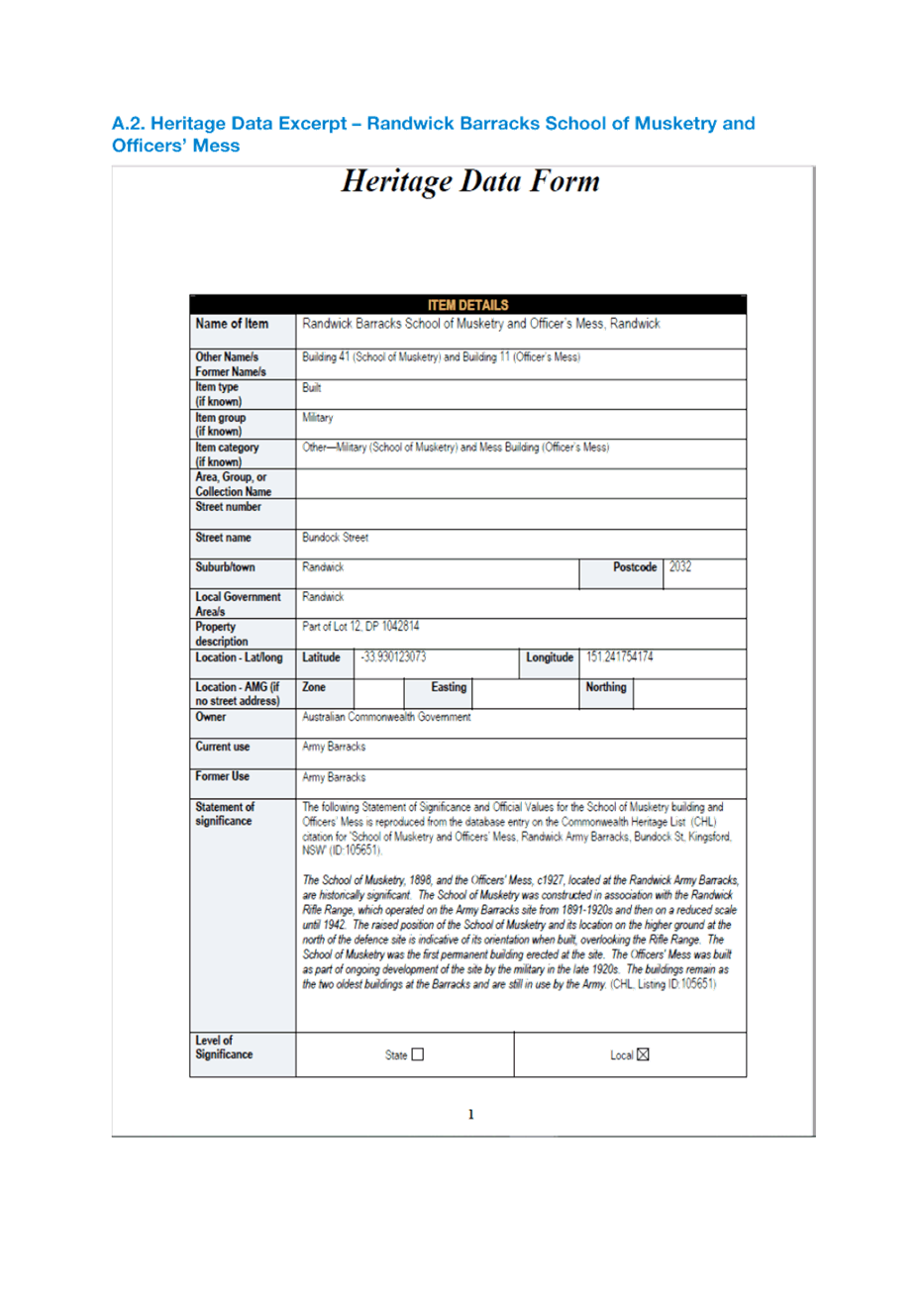
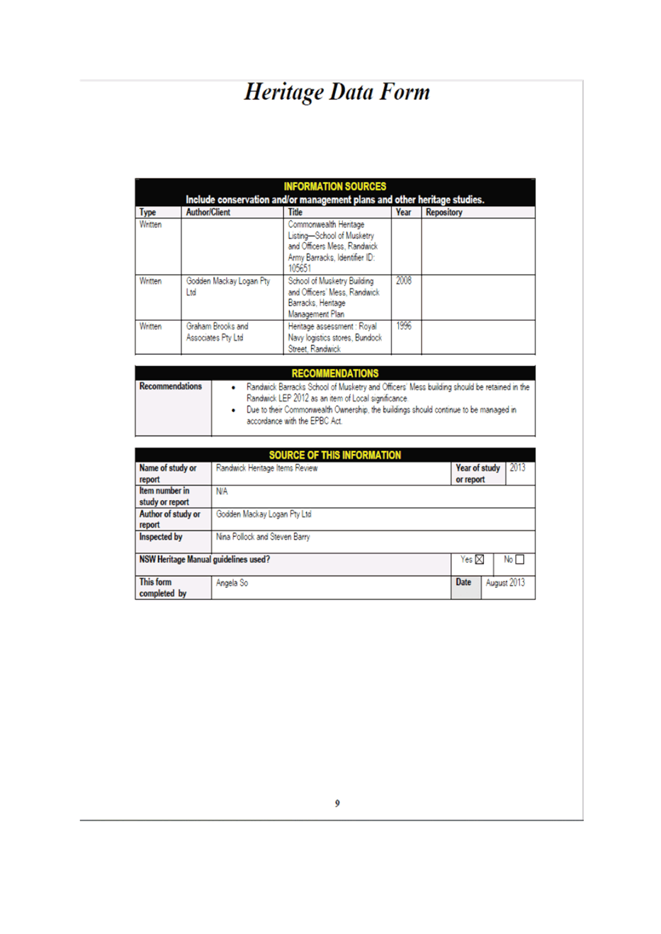
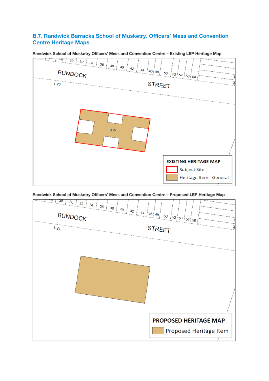
Randwick Barracks School of Musketry, Officers’ Mess and Convention Centre
The subject site known as 1-23 Bundock Street (Part of Lot 12, DP 1042814) (I310) is listed as a Heritage Item in Schedule 5 of the RLEP.
A heritage consultant investigation has recommended amended curtilage of the Randwick Barracks to include the courtyard spaces and motor garage. An excerpt of the consultant’s report is included in Attachment 9. Proposed map changes are also in Attachment 10.
|
Figure 7: Randwick Barracks School of Musketry. Officers’ Mess and Convention Centre |
|
|
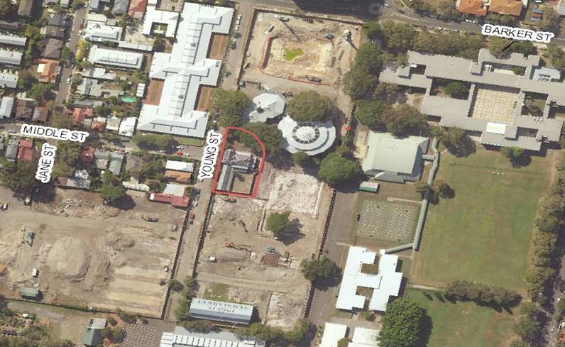
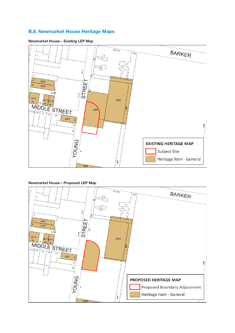
Newmarket House
The subject site known as 7 Young Street (Lot 38, DP 1264010) is listed as a heritage item in Schedule 5 of the RLEP 2012 known as “Newmarket House”. The existing heritage map within the RLEP overlaps the boundary of Lot 38 and does not entirely cover the subject site.
It is proposed that the heritage map is amended to only cover Lot 38, DP 1264010 as per Attachment 10.
|
Figure 8: Newmarket House |
|
|
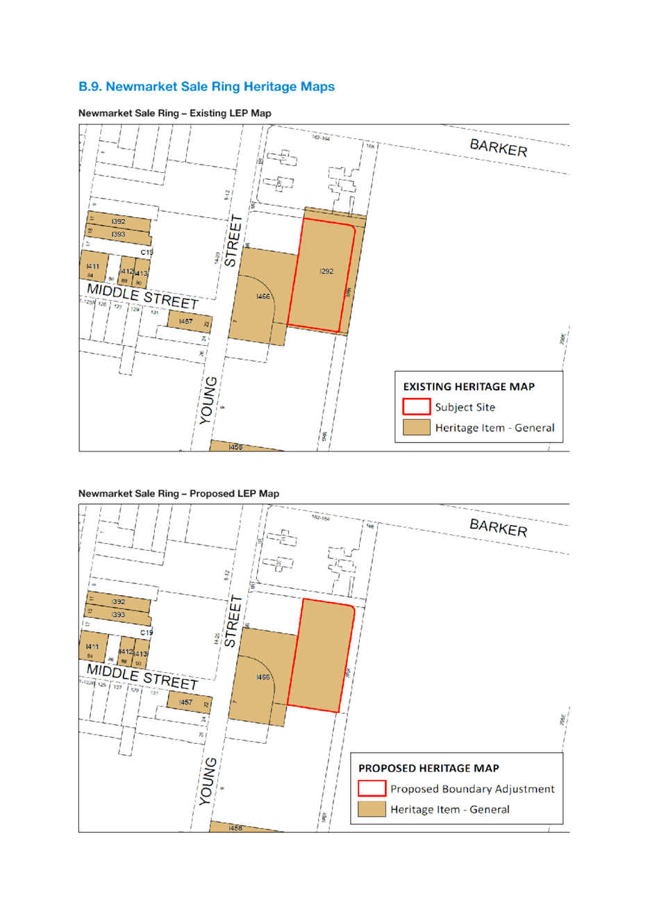
Newmarket Sale Ring
The subject site known as 5R Young Street (Lot 34, DP 1262464) is listed as a heritage item in Schedule 5 of the RLEP 2012 known as “Newmarket Sale Ring”. The existing heritage map within the RLEP overlaps the boundary of Lot 34 and should be amended to cover only a part of Lot 34. Proposed map changes are in Attachment 10.
|
Figure 9: Newmarket Sale Ring |
|
|
Mapping Anomalies
A number of mapping anomalies relating to zoning and/or development standards as well as changes due to approved development have been identified as a result of the rollover from the former Randwick Local Environmental Plan 1998 (RLEP 1998) to the current RLEP 2012. Proposed amendments to address these anomalies are described as follows:
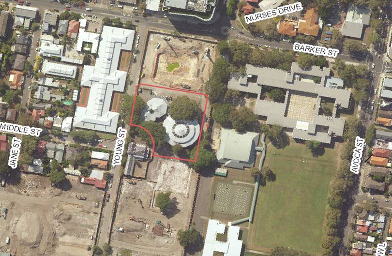
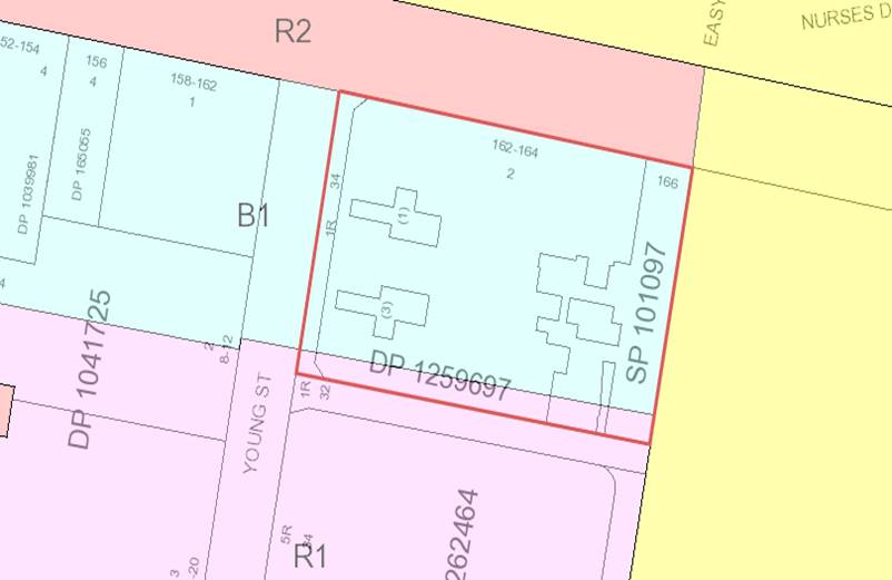
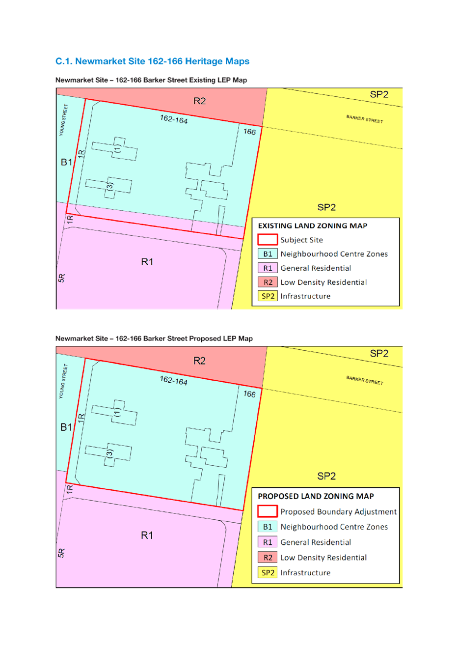
Newmarket Site – 162-166 Barker Street, Randwick
It is recommended that the zone boundaries of Lots 1 and 2 DP 159697 and SP 101097 are amended that results in the lots being completely within the B1 Neighbourhood Centre Zone.
|
Figure 10: Newmarket Site -162-166 Barker Street, Randwick |
|
|
Schedule 2 of RLEP 2012 outlines the exempt development provisions applicable to the LGA. This clause is as follows
Special events and temporary use of land (including erection of associated temporary structures such as stalls, shade structures, marquees, stages, etc)
(1) Must be a community activity, event or function.
(2) Must take place on a road, or the grounds of a school, place of public worship, hospital or other public land or land that is in a recreation zone or a special purpose zone.
(3) Maximum area of temporary structures—200m2.
(4) Must provide sufficient sanitary facilities for patrons and staff.
(5) Operator must have made arrangements for the collection, by an authorised trade waste contractor, of waste and recyclable materials that are generated by the event or use.
(6) Each stall and vendor must be registered with the Council before the event starts.
(7) Must have obtained any necessary approval to stage the event.
(8) If on Crown land or land under the care and control of the Council, golf courses, Randwick Racecourse or the University of New South Wales on an occasional basis, may be up to 10 days and with a maximum of 5,000 patrons at any one time and consistent with any plan of management that may apply to the land.
(9) If not on land referred to in subclause (8), may be up to 3 days only, between 7.00 am and 10.00 pm, with a maximum of 2,000 patrons at any one time, except with the prior written approval of the Council.
The above provision allows for a number of popular community events to run throughout the year on land that is owned or under the care of Council. To ensure further clarity and interpretation of these provisions and how they apply to markets, it is proposed that minor amendments to the existing provisions are made to improve its application and certainty for special events and temporary uses of land. This would only be permitted as exempt development on Crown Land or under the care and control of Council and not on other sites including school grounds which would be excluded.
Note that ‘market’ is defined in the LEP as “an open-air area, or an existing building, that is used for the purpose of selling, exposing or offering goods, merchandise or materials for sale by independent stall holders, and includes temporary structures and existing permanent structures used for that purpose on an intermittent or occasional basis”.
The proposed amendments to the exempt provisions of Schedule 2 are:
· Include the land use term ‘market’ in subclause (1)
· Include reference to markets in the provision to make it clear that the exempt provisions apply to markets
· Clarify that the exempt provisions apply only to Crown land or under the care and control of Council (excluding schools)
· Amend subclause (3) to ensure that the maximum area of all temporary structures is not to exceed 200m2 combined.
The minor amendments proposed ensures certainty and provides clarification in regard to how the specific provisions are interpreted.
Strategic alignment
The relationship with the City Plan is as follows:
|
Outcome/Direction |
Delivery Program actions |
|
Outcome |
6. A liveable city. |
|
Direction |
6d. A stategic land use framework provides for our lifestyle changes and for a continuing, yet steady rate of growth across our City. |
Resourcing Strategy implications
The review, data collection and analysis of the rezoning requests received was completed in-house by Strategic Planning officers with assistance from Consultant Strategic Planners.
Policy and legislative requirements
The Planning Proposal has been informed by the Environmental Planning and Assessment Act 1979 and the strategies and plans prepared under the Act including the Greater Sydney Commission’s Greater Sydney Region Plan (A Metropolis of Three Cities), Eastern District Plan, State Environmental Planning Policies, Ministerial Directions and Randwick Local Strategic Planning Statement.
Conclusion
This report seeks advice from the Panel in relation to the following matters:
· Housing investigation areas – no changes to the previously recommended heights and FSRs for the five housing investigation areas given the urban design analysis undertaken as well as the need to provide additional housing in accordance with Council’s Housing Strategy to meet the 6-10 year housing targets identified in the Eastern City District Plan
· Affordable housing contributions options in the housing investigation areas – based on the urban design analysis (FSRs) and independent economic feasibility analysis, an increase in the affordable housing contribution to 5% in the Kensington North and R3 Medium Density residential area of West Randwick is recommended. The remaining 3 HIAs and B1 zoned area of West Randwick will maintain the previously recommended 3% affordable housing contribution.
· Heritage items identified as part of the Randwick Junction Town Centre Strategy – the Randwick Junction Town Centre has been deferred from the Comprehensive Planning Proposal, however a number of items have been identified within this area for inclusion as new heritage items; 1 Belmore Road,167-171 Alison Road and 179-181 Alison Road, Randwick and extend the curtilage of the heritage item at No 60 Belmore Road to include the adjoining address known as 25 Waratah Avenue Randwick
· Housekeeping and minor amendments – a number of amendments (including misdescriptions, zone boundary adjustments, exempt development provisions including markets and typographical errors) to Randwick Local Environmental Plan 2012 that have been identified during the operation of the instrument are addressed in this report.
The advice of the Panel along with its previous advice on 8 March, 6 April and 13 April will be included in the Comprehensive Planning Proposal report scheduled to be reported to Council’s 1 June 2021 Extraordinary Council Meeting. This report will be seeking endorsement of the Planning Proposal for submission to the Department of Planning, Industry and Environment for Gateway Determination.
Responsible officer: Stella Agagiotis, Manager Strategic Planning; Timothy Walsh, Environmental Planning Officer
File Reference: F2021/00188
|
Randwick Junction Town Centre Post Exhibition Report - Council resolution - 27 April 2021 |
Attachment 8 |