![]()
![]()

Randwick Local Planning Panel (Electronic) Meeting
Thursday 13 May 2021
 |
|||
 |
|||
![]()
![]()
Randwick Local Planning Panel (Electronic) Meeting
Thursday 13 May 2021
|
|||
|
|||
Randwick Local Planning Panel (Electronic) meeting
 |
Randwick Local Planning Panel (Electronic)
Notice is hereby given that a Randwick Local Planning Panel (Electronic) meeting
will be held in the Online via Microsoft Teams on
Thursday, 13 May 2021
Declarations of Pecuniary and Non-Pecuniary Interests
Development Application Reports
D25/21 53-53A Denning Street, South Coogee (DA/644/2020).................................................. 1
D26/21 89 Gilderthorpe Avenue, Randwick (DA/279/2020)...................................................... 77
D27/21 22 Gordon Street, Randwick (DA/42/2021)................................................................ 155
Kerry Kyriacou
Director City Planning
Randwick Local Planning Panel (Electronic) meeting
|
Development Application Report No. D25/21
|
|
Subject: 53-53A Denning Street, South Coogee (DA/644/2020) |
|
Proposal: Demolition of existing residential flat building and construction of a part 1 and part 4 storey dwelling house, garage in the frontage, swimming pool at the rear, landscaping and associated works Ward: East Ward Applicant: Cullen Feng Pty Ltd Owner: Ms M L Feng & Mr J D Cullen Cost of works: $1,686,103.47 Reason for referral: Variation to Height of Building Development Standard in the RLEP 2012 Recommendation A. That the RLPP is satisfied that the matters detailed in clause 4.6(4) of Randwick Local Environmental Plan 2012 have been adequately addressed and that consent may be granted to the development application, which contravenes the Height of Building development standard in Clause 4.3 of Randwick Local Environmental Plan 2012. The concurrence of the Secretary of Planning, Industry and Environment may be assumed.
B. That the RLPP grant
consent under Sections 4.16 and 4.17 of the Environmental Planning and
Assessment Act 1979, as amended, to Development Application No. DA/644/2020
for demolition of existing residential flat building
and construction of a part 1 and part 4 storey dwelling house, garage in the
frontage, swimming pool at the rear, landscaping and associated works, at No. No. 53-53A Denning Street, South Coogee, subject to the
development consent conditions attached to this report.
|
|
|
|
|
|
|
Subject Site |
|
|
|
|
|
Submissions received
Ù North
|
|
|
Locality Plan |
1. Executive summary
The application is referred to the Randwick Local Planning Panel (RLPP) as the development contravenes the development standard for building height by more than 10%.
The proposal seeks development consent for demolition of existing attached dual occupancy and construction of a part 1 and part 4 storey dwelling house, garage in the frontage, swimming pool at the rear, landscaping and associated works.
The proposal was notified in accordance with Randwick Community Participation Plan 2019 and a total of two (2) submissions were received. The issues raised in the submissions primarily relate to side and rear setbacks, extent of built form to the rear, view loss and acoustic and privacy impacts.
The key issues associated with the proposal relate to non-compliance with the Height of Building development Standard in the Randwick LEP 2012, privacy and potential view loss impacts.
The building height variation is largely associated with the topography that slopes down from the street to the rear. As a result, the front of the building reads as single storey and is significantly under the maximum permitted height, and the resulting four storeys at the rear are generally consistent with neighbouring development and will not result in any unreasonable adverse impacts. The view loss assessment concluded that the views to the neighbouring properties will be retained and the non-compliant building height does not contribute to any view loss impacts. The proposal also meets the side and rear setback objectives set out in the Randwick DCP 2013.
Further, the proposed development complies with the external wall height control for sloping sites; and the height, bulk and scale of the development is compatible with other dwelling houses in the neighbourhood and is an appropriate design that relates to the typography and its context.
Amended plans have been received addressing the privacy concerns including associated backfill to the rear of the site. The proposed backfill to the rear is not expected to cause significant privacy impacts as the level of the lawn area has been lowered and is setback an additional metre from the rear boundary fence by introducing a second retaining wall and intermediate height planter with Rhaphis palm planting so there would now be two layers of screening vegetation between the lawn and the rear boundary fence. The gravel area east of the pool is also reduced in level and includes replacement of screening vegetation between the gravel area and the existing boundary.
The building height variation is supported as proposed development will be consistent with the objectives of the Height of Building standard and the R2 Low Density Residential zone. The applicant’s written request to vary the standard has adequately addressed those matters that are required to be demonstrated pursuant to Clause 4.6 of RLEP 2012. In addition, the variation is assessed as being within the public interest given that it will not result in adverse amenity impacts and is compatible with the desired future character of the area, and the site is suitably sized to accommodate the variation without resulting in adverse impacts.
The proposal is recommended for approval subject to non-standard conditions that require privacy measures to be implemented to the far northern corner windows to the eastern end of the building on the second and third floor levels.
2. Site Description and Locality
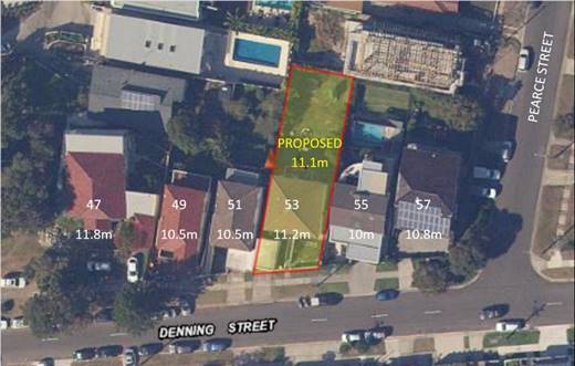
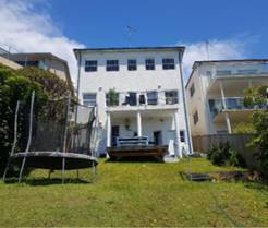
The subject site is known as No. 53-53A Denning Street, South Coogee and is legal described as Lot 1 in DP120679. The site is located on the southern side of Denning Street and is a generally rectagular shape allotment with an angled frontage width of 12.905m to Denning Street, side boundary detpths of 41.655m to the northern boundary and 38.33m to the southern boundary and a total site area of 498.8m². The site has a signifcant slope of approximately 13.37m from Denning Street to the rear of the boundary.
The site is currently occupied by an exisitng part two/part three storey attached dual occupancy.
The surrounding area consists of low-density residential development predominately characterised by single or two storey built from facing the street with part 3 storey or part 4 storey dwelling houses and dual occupancies to the rear due to the typography of the sites which significantly drops towards the rear.
Adjoining the property to the south at no. 51 Denning Street is a part 2 and part 3 storey dual occupancy development and to the north at no. 55 Denning Street is a part 2 and part 3 storey dwelling house. Adjoining the subject site to the rear at no. 2 Pearce Street is a part 2 and part 3 storey dwelling house.
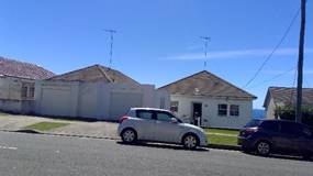
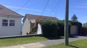
Figure 1: Streetscape view of the subject and neighbouring properties
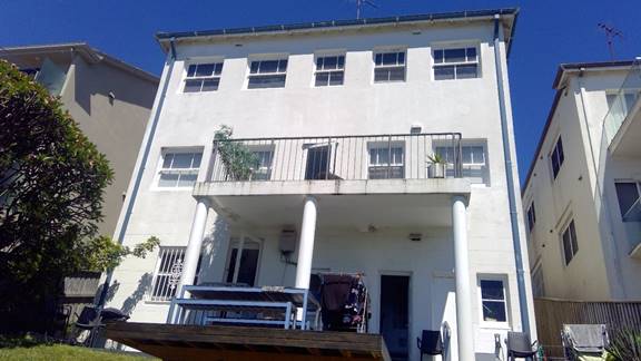
Figure 2: Rear of existing building on the subject site
3. Relevant history
There is no relevant history related to this development application.
4. Proposal
The proposal seeks development consent for demolition of the existing attached dual occupancy and construction of a part 1 and part 4 storey dwelling house, garage in the frontage, swimming pool at the rear, landscaping and associated works.
Amended plans have been received by Council on three occasions to address concerns raised by Council and objectors in relation to view loss, privacy and FSR calculation. On the first occasion (received by Council on 18/01/2021), the following amendments were made:
In response to the objection from No. 2 Pearce Street:
· Finished level of new lawn area has been reduced by 300mm by introducing two further steps between the proposed deck and the lawn area.
· The lawn area has been setback an additional metre from the rear boundary fence by introducing a second retaining wall and intermediate height planter with Rhaphis palm planting so there would now be two layers of screening vegetation between the lawn and the rear boundary fence.
· The proposed Frangipani tree has been relocated closer to the southeast corner of the proposed lawn area so that it will maximise screening of the rear living room balcony of No. 2 Pearce Street.
· All glass balustrades will be clear toughened frameless glass and the finishes schedule has been updated to show the changes.
· Existing and proposed fence lines are clearly noted on the section drawings.
· A small portion of the fence is raised to achieve 1.8m at the boundary relative to the new lawn level of No. 53 Denning Street (which is approximately 300mm lower than lawn level of No. 55 Denning Street).
· At the southwest end of the fence, it is proposed to overclad and extend the existing colorbond fence in timber slats to near the top of the existing hedge to No. 55 Denning Street.
· The landscape plan has been updated to reflect the above changes. Also to clearly state the height of the two proposed trees in the rear garden. The landscape plan shows the tree in the southwest corner is a PG Plumeria (Frangipani Tree) and height is stated as 4-5m. The tree in the northeast corner of the site is a PT Pandanus Tectorius (Screw Pine) and height is stated as 4-5m.
· View loss analysis was prepared for No. 51 and 55 Denning Street.
· The SEE is updated to reflect the proposed changes and to correct the site coverage calculation.
On the second occasion, amended plans were received by Council on 21/03/2021. The following amendments were made:
- The FSR was reduced by approximately 0.78 sqm by reducing the size of Bedroom 4 on Level 2. This reduces the GFA to 324.10 sqm and the FSR to 0.6495:1 which now complies with the LEP control of 0.65:1.
On the third occasion, amended plans were received by Council on 12/04/2021. The following amendments were made:
- Levels to the rear garden have been further lowered by introducing 3 additional steps down from the pathway to the lawn area. This will reduce the lawn level by 530mm with an RL of 36.05 at bottom of the steps and 35.75 at the eastern retaining wall before the planters step down to the existing ground level at the eastern boundary fence.
- The gravel area east of the pool is reduced in level similarly by 500mm. The proposed plans include replacement of screening vegetation between the gravel area and the existing boundary fence of No 1 Wisdom Street including a small tree and hedging vegetation.
- The proposed increase in height of the southern boundary timber fence with No. 55 Denning Street in the southeast corner has been removed.
5. Notification
The owners of adjoining and likely affected neighbouring properties were notified of the proposed development in accordance with the Randwick Comprehensive DCP 2013. The following submissions were received as a result of the notification process:
· 55 Denning Street, South Coogee
· 2 Pearce Street, South Coogee
|
Issue |
Comment |
|
Rear setback & view loss impacts The controls at clause C1 3.3.3 require additional setbacks for those developments which are at a minimum at (i) if they are needed to protect against view loss and the other loss of amenity including protection of privacy and solar access.
The location of the rear blade wall on Level 3 will cause substantial view loss issues to the living and dining areas of no. 55 Denning Street. Also, the privacy louvers on the balcony of this level which cause the same amount of impact and these should be deleted.
The location of the rear blade walls on Level 2 from their master bedroom will also cause similar view loss impacts.
The extent of the masonry wall to the southern end of the pool terrace near the BBQ will create a large blank wall and will prevent views, solar and light towards the North – East of No. 55 Denning Street.
|
An assessment of the value of views to be affected by the proposed development has been carried out below under the Key Issues section of this report. The assessment concluded that the qualitative assessment of the extent of the impact is considered very minor and the impacts are not associated with non-compliance with the planning controls. The height, bulk and scale of the development is also considered to be compatible with other dwelling houses in the neighbourhood and is an appropriate design that relates to the topography and its context.
Further, the proposed rear setback complies with the DCP control and will be consistent with the established rear setbacks and built forms in the area.
Refer to detailed assessment below in the Key Issues section under Sub-Section 5.6 – View Sharing.
|
|
Lack of side setback on southern elevation Concerned about the lack of articulation on the built form and size and bulk proposed for the building. The proximity of the upper levels to their northern elevation of No. 55 Denning Street and lack of design elements consistent with the RDCP will cause concerns for them if they choose to develop their property in the future.
|
Refer to Key Issues below under Sub-section 3.3.2 - Side setbacks, which addresses this concern. |
|
Extent of building form on Level 1 Concerns with the extension of Level 1 and the interaction of the southern wall and the BBQ deck and rear terrace that is the main outdoor living area. The development proposed plant room of a size and proportion that is inconsistent with the use of the premises. This level could be pushed back by at least 1-1.5m to reduce the bulk of the sheer wall on the south.
|
The proposed rear setback complies with the DCP control and will be consistent with the established rear setbacks and built forms of adjoining development as demonstrate below.
Refer to Key Issues below under Sub-section 3.3.2 - Side setbacks, which addresses the side setbacks of the development complying with the objectives of the control.
Aerial view showing predominate building line.
|
|
Acoustic and privacy impacts The extent and size of the rear terrace area on Level 2 will result in visual and acoustic privacy impacts to the adjoining property at No. 55 Denning Street.
|
Refer to Key Issues below under Sub-Section 5.3 - Visual & Acoustic Privacy which addresses this concern.
|
|
Landscaping The adjoining property at No. 55 Denning Street would like a better understanding of the proposed landscape plan. They do not wish the planting at the rear to be higher than 4m as it will impact on their view and solar access.
They have also noted that they do not want any raised planter boxes on any roof or any balcony or terrace area to protect their views.
|
A detailed written response by the applicant and several amendments have been made to the plans in an effort to address these concerns.
Refer to Landscape referral comments which addresses this section.
|
|
Overlooking impacts due to raising of rear yard level The raised level to the rear yard of the subject site will cause direct overlooking impacts to the rear yard and balcony of no. 2 Pearce Street.
|
Agreed. Amended plans have been received lowing the level of the rear yard and amendments have been made to address privacy and overlooking impacts. Refer to Key Issues below under Sub-Section 5.3 - Visual Privacy which addresses this concern. |
5.1. Renotification
The amended plans and documents do not require to be renotified as the proposed changes are reducing the impacts and will not result in additional amenity impacts on neighbouring properties or the street.
6. Relevant Environment Planning Instruments
6.1. SEPP (Vegetation in Non-rural Areas) 2017
The Vegetation SEPP came into effect in NSW on 25 August 2017. The aims of the Vegetation SEPP are:
“(a) to protect the biodiversity values of trees and other vegetation in non-rural areas of the State, and
(b) to preserve the amenity of non-rural areas of the State through the preservation of trees and other vegetation.”
Clause 7(1) requires a permit to be granted by the Council for the clearing of vegetation in non-rural areas (such as City of Randwick).
Assessing officer’s comment:
There is no substantial vegetation within this site that will be removed. There is a Frangipani in the rear setback, along the southern boundary, adjacent the southeast corner of the existing dwelling which is shown as being retained and incorporated as an existing site feature into the new landscape scheme. The landscape officer has advised that is would not be physically possible to retain due to a combination of the steep fall of land down to the east, and the resulting significant excavations and changes to ground levels that would need to be performed here, hard up against its northern aspect, which exceeds the tolerances specified in the Australian Standard.
Refer to detailed assessment made by Council’s Landscape Officer below under Appendix 1.
The proposed landscaping will increase the quality and amount of vegetation on site and will protect biodiversity values.
6.2. SEPP (Coastal Management) 2018
The subject site is identified within the SEPP as an area located within the coastal zone, specifically the Coastal Use Area. The relevant provisions within SEPP have been considered below to ensure that development within the coastal zone is appropriately managed and environmental assets of the coast are protected. The development satisfies the relevant aims and objectives of the SEPP.
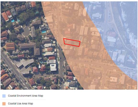
Coastal Environment Area and Coastal Use Area Map overlay with the subject site highlighted.
Clause 14 Development on land within the coastal use area
The proposed development has been appropriately designed and sited to mitigate any potential adverse impacts on any of the following:
· existing, safe access to and along the foreshore, beach, headland or rock platform for members of the public, including persons with a disability,
· overshadowing, wind funnelling and the loss of views from public places to foreshores,
· the visual amenity and scenic qualities of the coast, including coastal headlands,
· Aboriginal cultural heritage, practices and places,
· cultural and built environment heritage
The proposal would not result in any significant adverse impacts in relation to the above aspects and in management of the site given that the proposed works are contained within the site. The bulk and scale and size of the proposed development is compatible with the surrounding coastal zone and built environment and would not adversely affect the visual amenity or scenic qualities of the area, shadowing, wind, views or access to and along the foreshore and beach. The proposed colours, materials and finishes of the building would be consistent with other properties within the streetscape and will provide a uniform appearance that will enhance the visual presentation within the coastal zone.
Clause 15 Development in coastal zone generally – development not to increase risk of coastal hazards
The proposed development has limited potential to increase risk of coastal hazards given the siting, design and scale of the development.
Clause 16 Development in coastal zone generally – coastal management programs to be considered
There is no applicable coastal management program which would apply to the subject site arising from the carrying out of the proposed development.
6.3. SEPP 55 – Remediation of Land
The site history indicates a history of a residential nature. Therefore, it is not likely that the site has experienced any contamination.
State Environmental Planning Policy No 55-Remediation of Land State Environmental Planning Policy No. 55 - Remediation of Land (SEPP 55) provides planning guidelines for remediation of contaminated land. SEPP 55 requires the consent authority to be satisfied that “the site is, or can be made, suitable for the proposed use” prior to the granting of consent. Site history indicates that the site has been used for residential purposes for many years and therefore, it is not likely that the site has experienced any contamination.
In accordance with State Environmental Planning Policy No. 55, Council is able to conclude that no further assessment of contamination is necessary.
6.4. Randwick Local Environmental Plan 2012 (LEP)
The site is zoned R2 Low Density Residential under Randwick Local Environmental Plan 2012 and the proposal is permissible with consent.
The proposal is
consistent with the specific objectives of the zone in that the proposed
activity and built form will provide for the housing needs of the community
whilst enhancing the aesthetic character and protecting the amenity of the
local residents.
The following development standards in the RLEP 2012 apply to the proposal:
|
Clause |
Development Standard |
Proposal |
Compliance (Yes/No) |
|
Cl 4.4: Floor space ratio (max) |
0.65:1 (or GFA of 324.22m²)
|
0.6495:1 (or GFA of 324.10m²)
|
Yes |
|
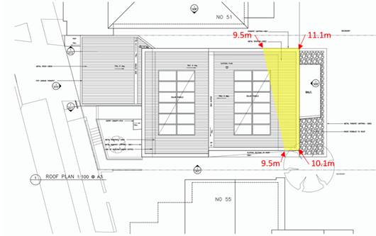
Cl 4.3: Building height (max) |
9.5m |
11.1m to the top of the ridge at the rear.
|
No. See Clause 4.6 - Exceptions to development standards below. |
6.4.1. Clause 4.6 - Exceptions to development standards
The non-compliances with the development standards are discussed in section 7 below.
6.4.2. Clause 6.7 Foreshore scenic protection area
The objectives of this clause are as follows:
(a) to recognise, protect and enhance the natural, visual and environmental qualities of the scenic areas of the coastline,
(b) to protect and improve visually prominent areas adjoining the coastal foreshore,
(c) to protect significant public views to and from the coast,
(d) to ensure development in these areas is appropriate for the location and does not detract from the scenic qualities of the coast.
The proposed development will have an aesthetic appearance that will not be detrimental to the visual qualities and amenity of the foreshore. The proposed building bulk, scale and height responds satisfactorily to surrounding topography and will integrate effectively with existing development within the foreshore area.
The proposal meets the relevant objectives outlined for Foreshore scenic protection areas under Clause 6.7 of the RLEP 2012.
7. Clause 4.6 exception to a development standard
The proposal seeks to vary the following development standard contained within the Randwick Local Environmental Plan 2012 (RLEP 2012):
|
Clause |
Development Standard |
Proposal
|
Proposed variation
|
Proposed variation (%) |
|
Cl 4.3: Building height (max) |
9.5m |
11.1m to the top of the ridge at the rear.
|
1.6m |
16.84% |
Clause 4.6 of RLEP 2012: Exception to a Development Standard relevantly states:
3. Development consent must not be granted for development that contravenes a development standard unless the consent authority has considered a written request from the applicant that seeks to justify the contravention of the development standard by demonstrating:
(a) that compliance with the development standard is unreasonable or unnecessary in the circumstances of the case, and
(b) that there are sufficient environmental planning grounds to justify contravening the development standard.
4. Development consent must not be granted for development that contravenes a development standard unless:
(a) the consent authority is satisfied that:
(i) the applicant’s written request has adequately addressed the matters required to be demonstrated by subclause (3), and
(ii) the proposed development will be in the public interest because it is consistent with the objectives of the particular standard and the objectives for development within the zone in which the development is proposed to be carried out, and
(b) the concurrence of the Secretary has been obtained.
In Initial Action Pty Ltd v Woollahra Municipal Council [2018] NSWLEC 118, Preston CJ summarised the matters in Clause 4.6 (4) that must be addressed before consent can be granted to a development that contravenes a development standard.
1. The applicant’s written request has adequately demonstrated that compliance with the development standard is unreasonable or unnecessary in the circumstances of the case
Chief Justice Preston in Initial Action Pty Ltd v Woollahra Municipal Council [2018] NSWLEC 118 reinforces his previous decision In Wehbe v Pittwater Council [2007] NSWLEC 827 where he identified five commonly invoked ways of establishing that compliance with a development standard is unreasonable or unnecessary in the circumstances of the case. The most common is to demonstrate that the objectives of the development standard are achieved notwithstanding non-compliance with the standard.
2. The applicant’s written request has adequately demonstrated that there are sufficient environmental planning grounds to justify contravening the development standard.
Chief Justice Preston in Initial Action Pty Ltd v Woollahra Municipal Council [2018] NSWLEC 118 reinforces the previous decision in Four2Five Pty Ltd v Ashfield Council [2015] NSWLEC 90 regarding how to determine whether ‘the applicant’s written request has adequately demonstrated that there are sufficient environmental planning grounds to justify contravening the development standard’.
The grounds relied on by the applicant in their written request must be “environmental planning grounds” by their nature. Chief Justice Preston at [23] notes the adjectival phrase “environmental planning” is not defined, but would refer to grounds that relate to the subject matter, scope and purpose of the EPA Act, including the objects in s1.3 of the EPA Act.
Chief Justice Preston at [24] notes that there here are two respects in which the written request needs to be “sufficient”.
1. The written request must focus on the aspect or element of the development that contravenes the development standard, not the development as a whole (i.e. The written request must justify the contravention of the development standard, not simply promote the benefits of carrying out the development as a whole); and
2. The written request must demonstrate that there are sufficient environmental planning grounds to justify contravening the development standard. In Four2Five Pty Ltd v Ashfield Council [2015] NSWLEC 90 at [31] Judge Pain confirmed that the term ‘sufficient’ did not suggest a low bar, rather on the contrary, the written report must address sufficient environmental planning grounds to satisfy the consent authority.
3. The proposed development will be in the public interest because it is consistent with the objectives of the particular standard and the objectives for development within the zone in which the development is proposed to be carried out.
Chief Justice Preston in Initial Action Pty Ltd v Woollahra Municipal Council [2018] NSWLEC 118 at [27] notes that the matter in cl 4.6(4)(a)(ii), with which the consent authority must be satisfied, is not merely that the proposed development will be in the public interest but that it will be in the public interest because it is consistent with the objectives of the development standard and the objectives for development of the zone in which the development is proposed to be carried out.
It is the proposed development’s consistency with the objectives of the development standard and the objectives of the zone that make the proposed development in the public interest.
If the proposed development is inconsistent with either the objectives of the development standard or the objectives of the zone or both, the consent authority, cannot be satisfied that the development will be in the public interest for the purposes of cl 4.6(4)(a)(ii).
4. The concurrence of the Secretary has been obtained.
Chief Justice Preston in Initial Action Pty Ltd v Woollahra Municipal Council [2018] NSWLEC 118 at [28] notes that the other precondition in cl 4.6(4) that must be satisfied before consent can be granted is whether the concurrence of the Secretary has been obtained (cl 4.6(4)(b)). In accordance with Clause 4.6 (5), in deciding whether to grant concurrence, the Secretary must consider:
(a) whether contravention of the development standard raises any matter of significance for state or regional environmental planning, and
(b) the public benefit of maintaining the development standard
Under clause 64 of the Environmental Planning and Assessment Regulation 2000, the Secretary has given written notice dated 21 February 2018, attached to the Planning Circular PS 18-003 issued on 21 February 2018, to each consent authority, that it may assume the Secretary’s concurrence for exceptions to development standards in respect of applications made under cl 4.6 (subject to the conditions in the table in the notice).
The approach to determining a clause 4.6 request as summarised by Preston CJ in Initial Action Pty Ltd v Woollahra Municipal Council [2018] NSWLEC 118, has been used in the following assessment of whether the matters in Clause 4.6(4) have been satisfied for each contravention of a development standard.
7.1. Exception to the Building Height development standard (Clause 4.3)
The applicant’s written justification for the departure from the Building Height standard is contained in Appendix 2.
1. Has the applicant’s written request adequately demonstrated that compliance with the development standard is unreasonable or unnecessary in the circumstances of the case?
The applicant’s written request seeks to justify the contravention of the Building Height development standard by demonstrating that compliance is unreasonable or unnecessary in the circumstances of the case because the relevant objectives of the standard are still achieved.
The objectives of the Building Height standard are set out in Clause 4.4 (1) of RLEP 2012.
The applicant has addressed each of the objectives as follows:
(a) to ensure that the size and scale of development is compatible with the desired future character of the locality
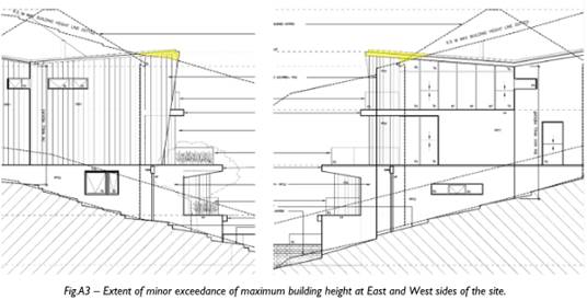
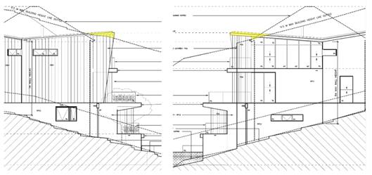
The applicant’s written justification demonstrates that this objective is satisfied by noting that the height of the proposed development is compatible with the group of properties in relation to the topography resulting in a portion of the building exceeding the maximum building height. The applicant also notes that the extent of exceedance is minor as indicated in the highlighted elevations in figure 3 below and the vast majority of the non-compliance is localised to the southern roof eave and not the enclosed building envelope.
The proposed development is not significantly different to the existing apartment building on the site in relation to general bulk and scale and it will appear lower when viewed from the street, refer to figure 4 below.
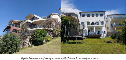
The proposed development is also consistent with the scale of the adjoining properties which generally have a storey visible above street level and 3 plus stories which are visible from the rear eastern elevation.
A fully compliant development would have the same bulk and scale viewed from the street and a very similar bulk and scale when viewed from the rear eastern elevation.
![]()
![]()
![]()
![]()
![]()
![]()
![]()
![]()
![]()
![]()
![]()
![]()
(b) to ensure that development is compatible with the scale and character of contributory buildings in a conservation area or near a heritage item,
The development is not within a conservation area or near a heritage item so the objective detailed in Clause 1(b) is not relevant to this development.
(c) to ensure that development does not adversely impact on the amenity of adjoining and neighbouring land in terms of visual bulk, loss of privacy, overshadowing and views.
The applicant’s written justification argues that this objective is satisfied by noting that the proposed devolvement is highly consistent in bulk and scale with adjoining development within this immediate area and the non-compliance only occurs at a lower RL relative to the street. The exceedance of the control does not result in a material difference in amenity impact on adjoining properties in relation to visual bulk.
The shadow diagrams show that there will be additional overshadowing impacts on part of the upper and mid-level balconies of No. 55 Denning Street between the hours of approx. 11am to 1pm. There are no significant impacts on the north facing living room windows of No. 5 Denning Street as the balconies at those levels are quite large and there is minimal impact prior to 11am, 3 hours of sunlight will be maintained to the principal outdoor living spaces including balconies and north facing windows. Refer to Figure 5 below which demonstrates the minimal overshadowing impacts as a result of the non-compliant building height.
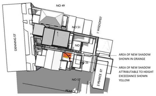
Figure 5 – Shadow impact on No. 55 Denning Street at 12 Noon Winter Solstice
The areas of the proposed building that exceed the height control are essentially the roof eaves of the uppermost storey and a small portion of a blade wall to the southern end of the upper floor. There are no habitable spaces containing a vantage point for overlooking of adjoining properties in the area of non-compliance.
The proposed development will result in minor view loss impacts from No. 51 & 55 Denning Street. The principal views are to the northeast towards Wedding Cake Island and the northern headlands between Coogee, Clovelly and Bronte. These iconic views from the main living area and rear balcony will be retained as demonstrated in Figure 6 - 9 below.
Assessing officer’s comment: In conclusion, the applicant’s written request has adequately demonstrated that compliance with the height of building development standard is unreasonable or unnecessary in the circumstances of the case.
As demonstrated throughout this report, the non-compliant building height portion does not result in any unreasonable adverse amenity impacts to neighbouring properties in terms of visual bulk, overshadowing, privacy and views nor will it impact on the streetscape. The development is considered to be compatible in bulk and scale with adjoining development within this immediate area and it is considered that the development will relate well to the context of the site, presenting as single storey to Denning Street and stepping down to the topography of the site at the rear.
Therefore, the proposed development will meet the objectives of the Height of Building development standard.
2. Has the applicant’s written request adequately demonstrated that there are sufficient environmental planning grounds to justify contravening the development standard?
The applicant’s written request seeks to demonstrate that there are sufficient environmental planning grounds to justify contravening the Height of Building development standard as follows:
· The proposed building height and area exceeding the building height control is less and smaller than the existing building. Therefore, the extent of exceedance of the maximum building height control will be an improvement on the existing non compliance.
· The existing building on the subject site and adjoining development within this section of the block already exceed the maximum building height control due to the topography of the site. Therefore, the scale and size of the development will be consistent with the developments patten in the immediate area.
· The non-compliant section is localised to the rear of the building where the site significantly drops and spans for a small section of the wall and will not result in any unreasonable adverse amenity impacts (in terms of overshadowing, visual bulk, privacy and views) to neighbouring properties or the streetscape. Moreover, majority of the building complies with the height of building standard.
· The non-compliance will not be inconsistent with existing and future planning objectives for the locality given the topography of the site.
Assessing officer’s comment: In view of the above, it is considered that the applicant’s written request has demonstrated that there are sufficient environmental planning grounds to justify contravening the development standard. In addition, it is noted that the portion of the building subject to the variation is largely the result of the topography, and the non-compliance does not result in increased amenity impacts in and of itself.
3. Will the proposed development be in the public interest because it is consistent with the objectives of the particular standard and the objectives for development within the zone in which the development is proposed to be carried out?
To determine whether the proposal will be in the public interest, an assessment against the objectives of the Height of Building standard and R2 zone is provided below:
Assessment against objectives of Height of Building standard
For the reasons outlined in the response to the R2 zone objectives as part of the building height standard discussion, the development is consistent with the objectives of the zone.
The development is consistent with the objectives of the Height of Building standard and the R2 Low Density Residential zone. Therefore, the development will be in the public interest.
4. Has the concurrence of the Secretary been obtained?
In assuming the concurrence of the Secretary of the Department of Planning and Environment the matters in Clause 4.6(5) have been considered:
Does contravention of the development standard raise any matter of significance for state or regional environmental planning?
The proposed development and variation from the development standard does not raise any matters of significance for state or regional environmental planning.
Is there public benefit from maintaining the development standard?
Variation of the maximum Height of Building standard will allow for the orderly use of the site and there is a no public benefit in maintaining the development standard in this instance.
Conclusion
On the basis of the above assessment, it is considered that the requirements of Clause 4.6(4) have been satisfied and that development consent may be granted for development that contravenes the Height of Building development standard.
8. Development control plans and policies
8.1. Randwick Comprehensive DCP 2013
The DCP provisions are structured into two components: objectives and controls. The objectives provide the framework for assessment under each requirement and outline key outcomes that a development is expected to achieve. The controls contain both numerical standards and qualitative provisions. Any proposed variations from the controls may be considered only where the applicant successfully demonstrates that an alternative solution could result in a more desirable planning and urban design outcome.
The relevant provisions of the DCP are addressed in Appendix 3.
9. Environmental Assessment
The site has been inspected and the application has been assessed having regard to Section 4.15 of the Environmental Planning and Assessment Act, 1979, as amended.
|
Section 4.15 ‘Matters for Consideration’ |
Comments |
|
Section 4.15 (1)(a)(i) – Provisions of any environmental planning instrument |
See discussion in sections 6 & 7 and key issues below.
|
|
Section 4.15(1)(a)(ii) – Provisions of any draft environmental planning instrument |
Nil. |
|
Section 4.15(1)(a)(iii) – Provisions of any development control plan |
The proposal generally satisfies the objectives and controls of the Randwick Comprehensive DCP 2013. See table in Appendix 3 and the discussion in key issues below.
|
|
Section 4.15(1)(a)(iiia) – Provisions of any Planning Agreement or draft Planning Agreement |
Not applicable. |
|
Section 4.15(1)(a)(iv) – Provisions of the regulations |
The relevant clauses of the Regulations have been satisfied. |
|
Section 4.15(1)(b) – The likely impacts of the development, including environmental impacts on the natural and built environment and social and economic impacts in the locality |
The environmental impacts of the proposed development on the natural and built environment have been addressed in this report.
The proposed development is consistent with the dominant character in the locality.
The proposal will not result in detrimental social or economic impacts on the locality. |
|
Section 4.15(1)(c) – The suitability of the site for the development |
The site is located in close proximity to local services and public transport. The site has sufficient area to accommodate the proposed land use and associated structures. Therefore, the site is considered suitable for the proposed development. |
|
Section 4.15(1)(d) – Any submissions made in accordance with the EP&A Act or EP&A Regulation
|
The issues raised in the submissions have been addressed in this report. |
|
Section 4.15(1)(e) – The public interest |
The proposal promotes the objectives of the zone and will not result in any significant adverse environmental, social or economic impacts on the locality. Accordingly, the proposal is considered to be in the public interest. |
9.1. Discussion of key issues
Randwick DCP 2013 - Part C1: Low Density Residential
Sub-section 3.3 - Setbacks
Objectives
· To maintain or establish a consistent rhythm of street setbacks and front gardens that contributes to the character of the neighbourhood.
· To ensure the form and massing of development complement and enhance the streetscape character.
· To ensure adequate separation between neighbouring buildings for visual and acoustic privacy and solar access.
· To reserve adequate areas for the retention or creation of private open space and deep soil planting.
· To enable a reasonable level of view sharing between a development and the neighbouring dwellings and the public domain.
Sub-section 3.3.2 - Side setbacks
Controls
i) Comply with the minimum side setbacks as follows:
|
Dwelling Houses & Dual Occupancies (Attached & Detached) |
|||
|
Frontage width |
Ground storey |
First storey |
Second storey & above |
|
Frontage widths greater than 12m. |
1.2m |
1.2m |
1.8m |
Any basement or semi-basement protruding less than 1.2m above ground level (finished) will not be counted as a storey. In this case, the “subfloor level” is taken to be the level immediately above and will be subject to the relevant side setback control.
A submission has been received objecting on the grounds about the lack of side setback and articulation on the southern elevation and the size and bulk of the proposed development.
The side setbacks are as follows:
Existing Ground Floor:
Northern side – 1.3m
Southern side – 1.3m
The proposed ground floor & lower ground floor are setback 1.2m from the northern and southern side boundaries.
The second floor level is setback 1.2m with the exception of the north western corner of the building which is sited on the northern side boundary.
The third floor level has a varied setback. The garage is sited on the northern side boundary with a nil setback and the front portion of the dwelling is setback 1.2m for a span of 5m and the remaining portion to the rear is setback 1.8m for a span of 6.66m.
Parts of the proposed development do not comply. The non-compliances are considered acceptable for the following reasons:
· The non-compliant portion to the northern side boundary on the second level is below street level and is recessed within the contours of the land. The garage portion to the northern boundary on the third floor level is primarily attached to the garage wall of the neighbouring garage at no. 51 Denning Street and will not result in any unreasonable visual, privacy or overshadowing impacts.
· The rear sections to the sides of the third level comply with the control of 1.8m which is the majority of the building and the sides of the walls have been appropriately articulated and modulated with openings and variety of materials.
· The proposed setbacks on the second floor level are consistent with neighbouring properties and the setbacks provided enables an acceptable building separation within the built form context of the site and acceptable privacy, solar access and views to be retained to the adjoining sites.
· The dwelling complies with the external wall height control and objectives in the DCP for sloping sites. The proposal also complies with site coverage and landscape controls in the DCP. When considered on balance with a compliant scheme, there are minimal additional environmental impacts resulting from the proposed setback variations.
The design of the proposed side elevations is considered to have minimised environmental impacts and therefore, will meet the objectives of the setback control.
Sub-section 5.3 - Visual Privacy
Privacy impacts have been raised from the neighbouring properties at Nos. 55 Denning Street & 2 Pearce Street in relation to the extent and size of the rear terrace area on Level 2 and the raised level to the rear yard of the subject site.
Amended plans have been received lowering the levels to the rear garden from RL 36.58 to RL 36.05. This will reduce the lawn level by 530mm with an RL of 36.05 at bottom of the steps and 35.75 at the eastern retaining wall before the planters step down to the existing ground level at the eastern boundary fence. The gravel area east of the pool is also reduced in level from RL 36.58 to RL 35.60. The proposed change in levels to the rear yard and the addition of a second planter along the rear boundary and substantial screen vegetation will restrict views particularly in a downward direction into the rear yard of No. 2 Pearce Street. In addition, the existing bamboo planting along the rear boundary fence has already grown above the top of the fence and will have matured significantly into a screening hedge by the time construction is complete.
The proposed plans include replacement of screening vegetation between the gravel area and the existing boundary fence of No. 1 Wisdom Street including a small tree and hedging vegetation which should maintain the current level of privacy between the properties. Whist it is noted that the ground level to this corner is 1.1m below the existing boundary fence height of No. 1 Wisdom Street, it is not expected that this area will be significantly used and therefore is not expected to result in significant privacy impacts.
The proposed increase in height of the southern boundary timber fence with No. 55 Denning Street in the southeast corner has been removed. There will be substantial screening plants on both properties along this boundary to maintain privacy levels.
Screen masonry wall and planting to the sides of the boundary of the pool terrace area provide reasonable levels of privacy to neighbouring properties.
The above measures will assist in maintaining reasonable privacy levels between the subject site and adjoining properties at No.’s 1 Wisdom Street and No. 2 Pearce Street which will minimise the current situation of significant overlooking from the rear yards between the properties.
In relation to the proposed window and door openings, it is expected that there will be a level of overlooking between properties when there are extensive views to be gained. The views are obtained from the rear of the property in an easterly direction and for this reason the window/door openings are mainly orientated to the rear eastern elevation in order to capture these extensive views beyond.
Majority of the window openings to the northern elevation on the second and third levels are of translucent glazing with the exception of the far northern corner windows to the eastern end of the building which are of fixed glazing and may cause privacy impacts. For this reason, a condition is included which requires these windows to be of either of translucent glazing or privacy screen louvres be installed which are to be spaced out and angled to prevent overlooking.
The window opening on the first floor level to the northern and southern elevations will be screened by the dividing fence.
The terrace/balconies are located to the rear with angled privacy screen louvres proposed to the southern end on all levels. On the second floor level the screen on the southern side does not extend the entire depth of the terrace. No screening is proposed to the northern sides of the terrace/balconies on all levels. This level of privacy is acceptable when considering there are ocean view beyond, other balconies within the rear have no screening and total privacy within these type of areas maybe further obstruct views to the subject and neighbouring properties.
Subject to conditions, the proposal is considered to meet the objectives of this control.
Sub-Section 5.6 - View Sharing
The objectives of the view sharing control are as follows:
§ To acknowledge the value of views to significant scenic elements, such as ocean, bays, coastlines, watercourses, bushland and parks; as well as recognised icons, such as city skylines, landmark buildings / structures and special natural features.
§ To protect and enhance views from the public domain, including streets, parks and reserves.
§ To ensure development is sensitively and skilfully designed to maintain a reasonable amount of views from the neighbouring dwellings and the public domain.
Controls
i) The location and design of dwellings and outbuildings must reasonably maintain existing view corridors or vistas from the neighbouring dwellings, streets and public open space areas.
ii) In assessing potential view loss impacts on the neighbouring dwellings, retaining existing views from the living areas (such as living room, dining room, lounge and kitchen) should be given a priority over those obtained from the bedrooms and non-habitable rooms.
iii) Where a design causes conflicts between retaining views for the public domain and private properties, priority must be given to view retention for the public domain.
iv) The design of fences and selection of plant species must minimise obstruction of views from the neighbouring dwellings and the public domain.
v) Adopt a balanced approach to privacy protection and view sharing, and avoid the creation of long and massive blade walls or screens that obstruct views from the neighbouring dwellings and the public domain.
vi) Clearly demonstrate any steps or measures adopted.
View loss assessment
Introduction
Sharing of views is a design performance requirement in Randwick Council’s Development Control Plan 2013.
An assessment of the proposed development and its impact on views is carried out in accordance with the Land and Environment Court planning principle after Roseth SC pp.25-29 in Tenacity Consulting v Warringah [2004] NSWLEC 140. This assessment is guided by a four step process identified by the Land and Environment Court.
1. Quality of views:
Step 1. “The first step is the assessment of views to be affected. Water views are valued more highly than land views. Iconic views (e.g. of the Opera House, the Harbour Bridge or North Head) are valued more highly than views without icons. Whole views are valued more highly than partial views, e.g. a water view in which the interface between land and water is visible is more valuable than one in which it is obscured.”
The views are identified in directions ‘A’ to ‘B’ in Figure 6 below. The views are obtained from the rear of the subject and adjoining sites over the roof tops of neighbouring properties in a north easterly, easterly and south easterly directions. The views are of the South Pacific Ocean and include Wedding Cake Island to the north east of the subject site which is an iconic view and Clovelly beach and headland interface views of Coogee, Clovelly and Bronte further to the north of the subject site. Some of the views are obscured by vegetation and roof tops of neighbouring properties beyond (see photos below).
![]()
![]()


![]()

![]()

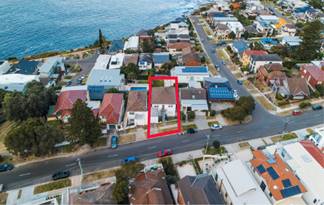
Figure 6: Location plans and the yellow hashed lines ‘A’ and ‘B’ identifies the direction of views obtained.
2. From what part of the property are the views obtained?
Step 2. The second step is to consider from what part of the property the views are obtained. For example the protection of views across side boundaries is more difficult than the protection of views from front and rear boundaries. In addition, whether the view is enjoyed from a standing from a standing or sitting position may also be relevant. Sitting views are more difficult to protect than standing views. The expectation to retain side views and sitting views is often unrealistic.
51 Denning Street, South Coogee
The diagrams and photos below in Figure 7 show the extent of the existing views and proposed view impacts. The views are obtained in a standing and sitting position off the living area and rear balcony.
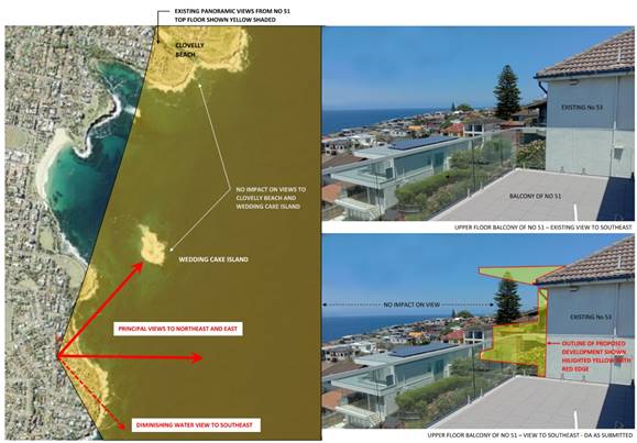
Figure 7: Existing and proposed view loss impacts
55 Denning Street, South Coogee
The diagrams and photos below in Figures 8 & 9 show the extent of the existing views and proposed view impacts. The views are obtained in a standing and sitting position off the main living area and rear balcony.
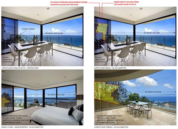
Figure 8: Existing and proposed view loss impacts
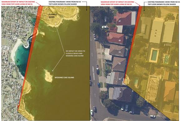
Figure 9: Plan view show extent of view loss impact and views that will be retained.
3. An assessment of the extent of the impact?
Step 3. The third step is to assess the extent of the impact. This should be done for the whole of the property, not just for the view that is affected. The impact on views from living areas is more significant than from bedrooms or service areas (though views from kitchens are highly valued because people spend so much time in them). The impact may be assessed quantitatively, but in many cases this can be meaningless. For example, it is unhelpful to say that the view loss is 20% if it includes one of the sails of the Opera House. It is usually more useful to assess the view loss qualitatively as negligible, minor, moderate, severe or devastating.
51 Denning Street, South Coogee
The views from the main living area and rear balcony will be retained as demonstrated in Figure 7 above.
55 Denning Street, South Coogee
The views from the main living area and rear balcony will be retained as demonstrated in Figures 8 & 9 above.
4. An assessment of the reasonableness of the proposal that is causing the impact?
Step 4. The fourth step is to assess the reasonableness of the proposal that is causing the impact. A development that complies with all the planning controls would be considered more reasonable than one that breaches them. Where an impact on views arises as a result of non compliance with one or more planning controls, even a more impact may be considered unreasonable. With a complying proposal, the question should be asked whether a more skilful design could provide the applicant with the same development potential and amenity and reduce the impact of views of neighbours. If the answer to that question is no, then the view impact of a complying development would probably be considered acceptable and the view sharing reasonable.
As demonstrated in the above assessment, the views to the nieghbouring properties will be retained.
The development complies with the LEP numerical controls in relation to FSR. The non compliant building height does not result in any view loss impacts and it has been demonstrated in the clause 4.6 that the height of the development is well founded and meet the objectives of the standard in the LEP.
The proposed development also complies with the external wall height control for sloping sites; and the height, bulk and scale of the development is compatible with other dwelling houses in the neighbourhood and is an appropriate design that relates to the typography and its context.
Given the above reasons, the development has been carefully configured to maintain view sharing between the site and the neighbouring properties.
10. Conclusion
That the application for demolition of existing residential flat building and construction of a part 1 and part 4 storey dwelling house, garage in the frontage, swimming pool at the rear, landscaping and associated works be approved (subject to conditions) for the following reasons:
· The applicant’s written request to vary the Height of Building development standard has been support as it adequately addressed the matters that are required to be demonstrated pursuant to Clause 4.6 of RLEP 2012.
· The proposal is consistent with the relevant objectives contained within the Randwick Local Environmental Plan 2012 and the relevant requirements of the Randwick Comprehensive Development Control Plan 2013.
· The proposal is consistent with the specific objectives of the R2 Low Density Residential zone in that the proposed activity and built form will provide for the housing needs of the community, contribute to the desired future character of the area and protect the amenity of residents.
· The scale and design of the proposal is considered to be suitable for the location and is compatible with the desired future character of the locality.
· The development enhances the visual quality of the public domain/streetscape.
Appendix 1: Referrals
1. Internal referral comments:
1.1. Development Engineer
This report is based on the following plans and documentation:
· Amended Architectural Plans by Cullen Feng Architects, rev A, dated 18.01.2021;
· Amended Statement of Environmental Effects by Cullen Feng Architects;
· Detail & Level Survey by Pang Surveyors dated 20.11.2020.
Parking Comments
Under Part B7 of Council’s DCP 2013 the proposed 4 bedroom residence is required to provide a minimum of 2 off-street car-spaces. The submitted plans do demonstrate compliance with this requirement.
The proposed garage and driveway do comply with the minimum requirements of Australian Standard 2890.1:2004 in regards to size, grades, and overhead clearances.
Drainage Comments
Detailed drainage plans with levels reduced to Australian Height Datum (AHD), shall be prepared by a suitably qualified Hydraulic Engineer and be submitted to and approved by the Principal Certifier. A copy of the plans shall be forwarded to Council, if Council is not the Principal Certifier.
Roof stormwater must be directed to a suitably designed and constructed rainwater tank, as required in the relevant BASIX Certificate for the dwelling. The overflow from the rainwater tank and other surface stormwater must be directed (via a sediment/silt arrestor pit) to a suitably sized infiltration area.
Undergrounding of power lines to site
At the ordinary Council meeting on the 27th May 2014 it was resolved that;
Should a mains power distribution pole be located on the same side of the street and within 15m of the development site, the applicant must meet the full cost for Ausgrid to relocate the existing overhead power feed from the distribution pole in the street to the development site via an underground UGOH connection.
The subject is not located within 15m of a mains power distribution pole on the same side of the street hence the above clause is not applicable.
Tree Management & Landscape Plan
There is no substantial vegetation within this site that would pose a constraint to these works in anyway, and while a Frangipani in the rear setback, along the southern boundary, adjacent the southeast corner of the existing dwelling, is shown as being retained and incorporated as an existing site feature into the new landscape scheme, this will not be physically possible due to a combination of the steep fall of land down to the east, and the resulting significant excavations and changes to ground levels that would need to be performed here, hard up against its northern aspect, which exceeds the tolerances specified in the Australian Standard.
These works will prevent its safe future retention, and even if this was attempted, the owners would still be allowed to remove this tree upon completion of the build, at anytime, without requiring consent from Council, due to being within 2m of the new building (exempt clause in our DCP), so for these reasons, conditions allow its removal and replacement, given that it is a common, exotic species, that is not significant to the site, local environment or native fauna in anyway, with the same also applying to the low value Cypress right on the northern boundary, which the survey confirms is wholly within this site.
The only other comments and conditions required are those that relate purely to the landscape treatment to be provided, with objections having been received from adjoining properties expressing concerns over the height of mature planting, and the resulting ‘loss of view’ this may cause of the ocean, Wedding Cake Island and their solar access.
A detailed written response by the applicant to these issues describes that several amendments have now been made to the plans in an effort to address these concerns, involving the introduction of additional stepped/terraced perimeter planters, as well as increasing the side setback of the rear lawn to side boundaries, both to minimise overlooking, as well as strategically relocating some of the previous planting, involving the use of common, coastal species, with those larger feature plants being those that have open habits (Pandanus) or even deciduous (Frangipani), which will assist with partial visual screening and privacy, without causing significant view loss, and will attain a small height at maturity of 4-6m as stated.
Appendix 2: Applicant’s written request seeking to justify the contravention of the development standard
RANDWICK LOCAL ENVIRONMENTAL PLAN 2012
CLAUSE 4.6 – EXCEPTIONS TO DEVELOPMENT STANDARDS
CLAUSE 4.3 HEIGHT OF BUILDINGS
APPLICANT'S NAME: Cullen Feng Pty Ltd
SITE ADDRESS: No. 53-53A Denning Street, Randwick
PROPOSAL: Demolition of existing apartment building, conversion to single dwelling, double garage to front, swimming pool to rear, landscaping and associated works
1.0 Introduction
This is a written request to seek an exception to a development standard pursuant to Clause 4.6 – Exceptions to Development Standards of the Randwick LEP 2012.
2.0 The Instrument and Relevant Clause
2.1 Name of the applicable planning instrument which specifies the development standard:
· Randwick Local Environmental Plan (LEP) 2012
2.2 Zoning of the land:
· R2 – Low Density Residential
a. Objectives of the Zone:
• To provide for the housing needs of the community within a low density residential environment.
• To enable other land uses that provide facilities or services to meet the day to day needs of residents.
• To recognise the desirable elements of the existing streetscape and built form or, in precincts undergoing transition, that contribute to the desired future character of the area.
• To protect the amenity of residents.
• To encourage housing affordability.
• To enable small-scale business uses in existing commercial buildings.
2.4 The Development Standard being varied:
Clause 4.3 – Height of Buildings
2.5 Nature of the Standard:
Clause 4.3 in the Randwick LEP refers to a Height of Buildings Map, which prescribes a maximum height for areas labelled J2 of 9.5m above existing ground level for the subject site.
2.6 Objectives of the Standard
(a) to ensure that the size and scale of development is compatible with the desired future character of the locality,
(b) to ensure that development is compatible with the scale and character of contributory buildings in a conservation area or near a heritage item,
2.7 Numeric Value allowable under the standard and extent of variance sought:
Allowable Maximum Height: 9.5m
Maximum Height of Proposed Development 11.1m
The maximum variation sought is an exceedance of 1.6m which equates to an exceedance of approximately 17% over the standard. The variation applies only to portion of the roof, and in the majority to the eave of the roof only. The exceedance varies from 1.6m (height of 11.1m) at the northeast corner of the roof to 0.6m (height of 10.1m) at the southeast corner of the roof.
The existing apartment building on the property has a similar maximum height of 11.2m with an exceedance of 1.7m at the roof ridge. The exceedance relates to a larger portion of the existing roof and is at a higher RL (RL 52.89 existing, RL 50.46 proposed) and therefore has greater amenity impact on neighbourhood views than the proposed development.
3.0 Assessment of Proposed Variation
3.1 Clause 4.6 Objectives
Clause 4.6 establishes a framework for justifying reasonable variation in development standards stated in the LEP. The objectives of the clause are as follows:
(1) The objectives of this clause are as follows—
(a) to provide an appropriate degree of flexibility in applying certain development standards to particular development,
(b) to achieve better outcomes for and from development by allowing flexibility in particular circumstances.
(2) Development consent may, subject to this clause, be granted for development even though the development would contravene a development standard imposed by this or any other environmental planning instrument. However, this clause does not apply to a development standard that is expressly excluded from the operation of this clause.
(3) Development consent must not be granted for development that contravenes a development standard unless the consent authority has considered a written request from the applicant that seeks to justify the contravention of the development standard by demonstrating—
(a) that compliance with the development standard is unreasonable or unnecessary in the circumstances of the case, and
(b) that there are sufficient environmental planning grounds to justify contravening the development standard.
(4) Development consent must not be granted for development that contravenes a development standard unless—
(a) the consent authority is satisfied that—
(i) the applicant’s written request has adequately addressed the matters required to be demonstrated by subclause (3), and
(ii) the proposed development will be in the public interest because it is consistent with the objectives of the particular standard and the objectives for development within the zone in which the development is proposed to be carried out, and
(b) the concurrence of the Planning Secretary has been obtained.
(5) In deciding whether to grant concurrence, the Planning Secretary must consider—
(a) whether contravention of the development standard raises any matter of significance for State or regional environmental planning, and
(b) the public benefit of maintaining the development standard, and
(c) any other matters required to be taken into consideration by the Planning Secretary before granting concurrence.
(6) Development consent must not be granted under this clause for a subdivision of land in Zone RU1 Primary Production, Zone RU2 Rural Landscape, Zone RU3 Forestry, Zone RU4 Primary Production Small Lots, Zone RU6 Transition, Zone R5 Large Lot Residential, Zone E2 Environmental Conservation, Zone E3 Environmental Management or Zone E4 Environmental Living if—
(a) the subdivision will result in 2 or more lots of less than the minimum area specified for such lots by a development standard, or
(b) the subdivision will result in at least one lot that is less than 90% of the minimum area specified for such a lot by a development standard.
Note—
When this Plan was made, it did not include Zone RU1 Primary Production, Zone RU2 Rural Landscape, Zone RU3 Forestry, Zone RU6 Transition, Zone R5 Large Lot Residential, Zone E3 Environmental Management or Zone E4 Environmental Living.
(7) After determining a development application made pursuant to this clause, the consent authority must keep a record of its assessment of the factors required to be addressed in the applicant’s written request referred to in subclause (3).
(8) This clause does not allow development consent to be granted for development that would contravene any of the following—
(a) a development standard for complying development,
(b) a development standard that arises, under the regulations under the Act, in connection with a commitment set out in a BASIX certificate for a building to which State Environmental Planning Policy (Building Sustainability Index: BASIX) 2004 applies or for the land on which such a building is situated,
(c) clause 5.4,
(ca) clause 6.16(3)(b).
From these objectives this request for a variation to the Standard should demonstrate that:
- Compliance with the Development Standard is unreasonable or unnecessary in the circumstances of the case.
- That the development achieves the objectives of the Standard, despite the exception.
- That the development achieves the objectives of the Zone in which it is located.
- That there are sufficient environmental planning grounds to justify contravening the development standard.
- That the exception to the Standard allows a better outcome for and from the development and is in the Public Interest.
- That approval of the development would not contravene the matters outlined in subsection (8).
3.2 Compliance is Unreasonable or Unnecessary
The subject site currently accommodates a three storey apartment building constructed c. 1920’s. The site falls significantly from Denning Street on the western boundary (RL 47) to the eastern boundary with No 2 Pearce Street (RL 34.5) – a height difference of about 13.5m. The steepest part of the site is immediately east of the street boundary with a fall of about 3.5m within the first 7m eastwards.
The site forms part of a group of six sites with similar topography bounded by No 57 at Pearce Street to the south and a park area north of No 47 Denning. All of the existing houses and apartment buildings in this group exceed the allowable maximum building height due to the steep topography. In all cases this relates to either the pitched roof ridge or the parapet of the top floor of the building at the point of the envelope furthest east.
![]()
The existing apartment building on the site of No 53 is no exception. It has a maximum building height of 11.2m at the roof ridge. In addition the existing eastern elevation gutter is nearly exactly 9.5m and a large portion of the existing pitched roof is therefore above the height limit.
The proposed development has a maximum building height of 11.1m (exceedance of 1.6m) at the northern end of the eastern roof eave. The buidling height reduces to 10.1 m at the southern end of the eastern roof eave (exceedance of 0.6m). The proposed average height of the eastern roof eave is therefore 10.6m which translates to an average exceedance of 1.1m.
The proposed building height is less than the existing building height. Furthermore the area of exceedance is smaller then the existing and mostly relates to a roof eave rather than a roof ridge. Also the non compliance occurs at a lower absolute level than the existing – RL 50.46 - which is 2.43m lower than the existing ridge non compliance of RL 52.89.
![]()
The extent of exceedance of the maximum buidling height control is therefore an improvement on the existing non compliance. It is also entirely consistent with the established pattern of development in the immediate area.
One of the principal objectives of any height control is to produce a consistency of scale and size of development. In circumstances where all of the neighbouring properties of relevance exceed the technical standard, consistency of development scale and pattern is clearly of more relvance than the numerical value of the standard.
In this case, the proposed development is wholly consistent with the existing development pattern in which a small portion of the building– either the roof ridge or eastern parapet/roof edge – exceeds the maximum building height by between 5 and 20% as a result of the steep topography. The proposed development exceeds the maximum height by 17.4% at the northeastern corner of its roof and by 6.3% at the southeastern corner.
It is therefore submitted that it would be both unreasonable and unnecessary to enforce strict compliance with the Standard in the contextual circumstances of the case.
3.3 Achievement of Objectives of the Standard
The objectives of the Standard and response to each are listed below:
(a) to ensure that the size and scale of development is compatible with the desired future character of the locality.
There is no specific statement of desired future character in the LEP for this area and it is assumed that the consistency with existing development and in particular more recently approved developments would give a reasonable guide to desired future character.
Of some relevance in this context would be the houses to the western side of Denning Street which generally have a contemporary character with multiple levels and a 3-4 storey appearance to the eastern façade. The proposed development is wholly consistent with these houses.
Of more relevance would be the bulk and scale of the existing houses to the east side of Denning Street from number 47-57 which form a group with similar topography.
As noted above the proposed development is highly consistent with this group of properties in relation to the topography resulting in a portion of the building exceeding the maximum building height. The extent of this exceedance for no 53 is quite minor as indicated in the highlighted elevations below. The vast majority of the non-compliance relates to the southern roof eave and not the enclosed building envelope.
![]()
The proposed development is also consistent with the scale of the adjoining properties which generally have a storey visible above street level and 3 plus stories visible at the eastern elevation. With the land falling away steeply to the east, most of these properties have terraces or decks or balconies built out from the lowest floor level which are part of a storey above the finished ground level – giving an overall visual height of more than three stories when viewed from directly from the east.
The proposed development is not significantly different to the existing apartment building on the site in relation to general bulk and scale – though it will appear lower when viewed from the street. And a fully complying development at 53 would have the same bulk and scale viewed from the street and a very similar bulk and scale when viewed from the east.
![]()
It is submitted therefore that the objective of limiting overall height to ensure size and scale of developments are compatible with desired future character is achieved regardless of the minor non-compliance of the eastern roof eave.
(b) to ensure that development is compatible with the scale and character of contributory buildings in a conservation area or near a heritage item,
This objective is not relevant to the subject site and application.
(c) to ensure that development does not adversely impact on the amenity of adjoining and neighbouring land in terms of visual bulk, loss of privacy, overshadowing and views.
Visual Bulk
As established above the proposed development is highly consistent in terms and bulk and scale with the existing properties in the relevant group, particularly those which have already been redeveloped – No’s 55 and 57 Denning Street. Furthermore, while the proposal includes a portion of building that exceeds the height control, that portion is smaller than the existing area of non-compliance of the existing building on the site and occurs at a lower RL relative to the street.
Visual bulk will therefore be reduced when viewed from the street and given the minor area of non-compliance, a fully complying scheme would have very similar visual bulk when viewed from the east.
It is submitted therefore that the exceedance of the control does not result in a material difference in amenity impact on adjoining properties in relation to Visual Bulk.
Overshadowing
Overshadowing is typically considered at the mid-winter solstice 21 June between the hours of 9am and 3pm. Randwick DCP 2012 however requires consideration of shadows and solar access at 21 June between the hours of 8am and 4pm. Shadow Diagrams at 8am, 12 noon and 4pm are required and have been submitted with the Development Application. During these hours, the proposed building at No 53 has nil additional shadow impact on any properties other than No 55 Denning Street.
Some additional shadow will fall on part of the upper and mid-level balconies of no 55 between the hours of approximately 11am and 1pm. There is no impact of the north facing living room windows of No 55. Because the balconies at those levels are quite large and there is minimal impact prior to 11am, 3 hours of sunlight at mid-winter is clearly maintained to the principal outdoor living spaces (including balconies) and north facing living room windows of No 55.
Within that area of additional overshadowing, only a small portion relates to the area of the proposed building roof over 9.5m high. The diagrams below indicate the extent.
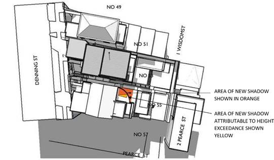
![]()
It is submitted that a development that strictly complied with the maximum building height limit would have a materially similar shadow impact on No 55 and in both cases the impact complies with the requirements of Council’s DCP with respect to preserving reasonable solar access to adjoining properties. It is therefore submitted the proposed height non-compliance has no material overshadowing impact on the amenity of the adjoining properties and the objective of the height control is upheld in this respect.
Privacy
As noted above and shown in Fig A3, the areas of the proposed building that exceed the height control are essentially the roof eaves of the uppermost storey and a small portion of a blade wall to the southern end of the upper floor. There are no habitable spaces containing a vantage point for overlooking of adjoining properties in the area of non-compliance. It is therefore submitted the proposed height non -compliance has no material privacy impact on the amenity of the adjoining properties and the objective of the height control is upheld in this respect.
View Impact/View Sharing
The existing pattern of development includes balconies and terraces and elevated decks over multiple levels to each of the houses in the relevant block. Given these occur over multiple levels are and are projected beyond the building line in many cases, there is inevitable overlooking between properties and sharing of views to the ocean across adjoining sites to northeast and southeast. The principal view is to the northeast towards Wedding Cake island and the northern headlands between Coogee and Clovelly and Bronte.
The pattern of development with the depth of houses running parallel to Denning Street (except for No 47) also means the view from each house is naturally oriented to the northeast given the adjoining house to the south projects further and the house to the north projects less in each case.
In this case therefore the principal view impact will relate to no 55 Denning Street to the south of the subject property. No 55 enjoys extensive views to the whole arc form northeast to southeast and further- probably about 150 degrees in total.
The proposed development will have some minor impact on views from No 55 however it will leave the vast majority of these views intact as can be seen in the view analysis below. Furthermore, the proposed height non compliance will make no contribution to any view loss to No 55. The upper balcony level of No 55 is at RL 46.53. The complying part of the proposed development in the relevant portion is at RL 49.9 and the non complying part at RL 50.6. The complying height is well above eye level from the upper floor of No 55.
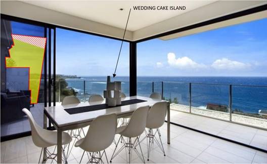
![]()
A fully complying building would therefore have the same view impact as the proposed development.
It should also be noted that the existing cypress pine to the north east corner of No 55 has a current height of about 6m and potentially would grow to 15m, significantly impacting the Wedding Cake Island/ocean views from both Nos 55 and 57. This tree is intended to be removed and replaced with Lilli Pilli hedging.
It is therefore submitted the proposed height non-compliance has no material view loss or view sharing impact on the amenity of the adjoining properties and the objective of the height control is upheld in this respect.
In summary, the Objectives of the relevant Standard are therefore achieved and not threatened by the minor non-compliance proposed.
3.4 Achievement of Objectives of the Zone
• To provide for the housing needs of the community within a low-density residential environment.
The proposal is for construction of a new residence. The proposed development is clearly consistent with this objective.
• To enable other land uses that provide facilities or services to meet the day to day needs of residents.
This objective is not strictly relevant to the proposed development, thought the proposal does include a home office which would not be inconsistent with this objective.
• To recognise the desirable elements of the existing streetscape and built form or, in precincts undergoing transition, that contribute to the desired future character of the area.
It would be fair to say the area is in transition from older style houses and apartments buildings to newer single residences. The proposed development is consistent with this pattern in that it replaces a small apartment building with new single family residence. The proposal has a contemporary design which is consistent with the most recent approvals in the nearby area including 74 Denning Street and the nearby properties on the west side of the street.
It is submitted therefore that the proposal is consistent with this objective.
• To protect the amenity of residents.
Amenity impacts of the development, specifically relating to the height non-compliance which is the subject of this Clause 4.6 submission, have been comprehensively addressed in the preceding section. The area of non-compliance does not result in a materially different outcome from an amenity perspective than would be the case with a complying scheme.
It is submitted the proposal is therefore consistent with this objective.
3.5 Sufficient Environmental Planning Grounds & The Public Interest
The proposed development is permissible within the R2 Low Density Residential zone and is consistent with the relevant zone objectives.
This Request demonstrates in Section 3.2 and 3.3 that the proposal also achieves all of the objectives of the relevant control, despite the technical exceedance.
Particularly given that the existing apartment building and all the other houses in the relevant block already exceed the Maximum Building Height Control, it is submitted that strict compliance with the control would be unreasonable and unnecessary in the circumstances of the case.
The proposed development is in the Public Interest as it represents an incremental development of the land that better realises its potential for residential use. It will also result in a lower building when viewed from the street and remove an apartment building which would not be able to built under the current zoning.
Therefore, the technical non-compliance will not be inconsistent with existing and future planning objectives for the locality and it is submitted that there are sufficient environmental planning grounds to justify exceedance of the development standard in the particular circumstances of the case.
3.6 A Better Outcome
The proposed new residence will significantly improve the aesthetic character of the street and continue the transition already underway from older building stock in a semi or fully dilapidated state to newer contemporary homes, resulting in a residence that positively contributes to the quality of the streetscape and locality generally.
Strict compliance with the height control would result is a diminished aesthetic and design result. It is submitted therefore that the allowance of flexibility in application of the relevant standard in this case will result in a better outcome for the site.
4.0 Conclusion
Development Standards contained within Planning Instruments are a means of implementing planning objectives. Clause 4.6 of the Randwick LEP 2012 allows for flexibility in the application of such standards in certain circumstances.
It has been shown that the objectives of the Planning Instrument and the particular Development Standard are achieved by the proposal and in fact the development enhances their achievement. A fully complying proposal would compromise the intended aesthetic design and result in a diminished visual outcome with no measurable improvement in amenity. The minor non-compliance in this case leads to a better outcome than a fully complying development.
It is submitted therefore that the Request for Variation is well founded; strict compliance with the standard would be unreasonable or unnecessary in the circumstances of the case; and sufficient environmental planning grounds have been demonstrated.
For these reasons it is submitted that the variation is minor, appropriate and consistent with the intent of Clause 4.6 and should be supported.
Appendix 3: DCP Compliance Table
3.1 Section C1: Low Density Residential
The DCP provisions are structured into two components, Objectives and Controls. The Objectives provide the framework for assessment under each requirement and outline key outcomes that a development is expected to achieve. The controls contain both numerical standards and qualitative provisions. Any proposed variations from the controls may be considered only where the applicant successfully demonstrates that an alternative solution could result in a more desirable planning and urban design outcome.
The relevant provisions of the DCP are addressed in the table below. (Note: a number of control provisions that are not related to the proposal have been deliberately omitted.)
|
DCP Clause |
Controls |
Proposal |
Compliance |
|
|
Classification |
Zoning = R2 Low Density Residential |
|
|
2 |
Site planning |
|
|
|
2.3 |
Site coverage |
||
|
|
Up to 300 sqm = 60% 301 to 450 sqm = 55% 451 to 600 sqm = 50% 601 sqm or above = 45% |
Site area = 498.8m²
Proposed = 41% (or 204m²) |
Complies |
|
2.4 |
Landscaping and permeable surfaces |
||
|
|
i) Up to 300 sqm = 20% ii) 301 to 450 sqm = 25% iii) 451 to 600 sqm = 30% iv) 601 sqm or above = 35% v) Deep soil minimum width 900mm. vi) Maximise permeable surfaces to front vii) Retain existing or replace mature native trees viii) Minimum 1 canopy tree (8m mature). Smaller (4m mature) If site restrictions apply. ix) Locating paved areas, underground services away from root zones. |
Site area = 498.8m²
Proposed = 151m² |
Complies |
|
2.5 |
Private open space (POS) |
||
|
|
Dwelling & Semi-Detached POS |
|
|
|
|
Up to 300 sqm = 5m x 5m 301 to 450 sqm = 6m x 6m 451 to 600 sqm = 7m x 7m 601 sqm or above = 8m x 8m |
Site area = 498.8m²
Proposed = A minimum of 7m x 7m of contiguous POS is provided to the rear of the dwelling. |
Complies |
|
3 |
Building envelope |
||
|
3.1 |
Floor space ratio LEP 2012 = |
Site area = 498.8m² Proposed FSR = 0.6495:1 (or GFA of 324.10m²) |
Complies |
|
3.2 |
Building height |
|
|
|
|
Maximum overall height LEP 2012 = 9.5m |
Existing = 12.98m
Proposed = 11.1m
|
Does not comply. Refer to Key Issues above under 4.6 Exemption. |
|
|
i) Maximum external wall height = 7m (Minimum floor to ceiling height = 2.7m) ii) Sloping sites = 8m iii) Merit assessment if exceeded |
Sloping sites = 8m
Proposed = 7.7m to underside butterfly roof eave from natural ground level. |
Complies |
|
3.3 |
Setbacks |
||
|
3.3.1 |
Front setbacks i) Average setbacks of adjoining (if none then no less than 6m) Transition area then merit assessment. ii) Corner allotments: Secondary street frontage: - 900mm for allotments with primary frontage width of less than 7m - 1500mm for all other sites iii) do not locate swimming pools, above-ground rainwater tanks and outbuildings in front |
Minimum = The garage to adjoining dwellings are sited on the front boundary. The dwellings are recessed with setbacks varying from approx. 5.2m to 7.2m (51 Denning Street) and 6.3m to 9.07m (55 Denning Street) from the front boundary.
Proposed = Due to the significant fall of the land from the front to the rear of the site. The third level is the street level.
The garage is sited on the boundary and is consistent with setback of neighbouring properties. The dwelling on this level is setback between 5.42m to 8.07m to due to the angle of the front boundary.
The front setback is considered to be generally consistent with the average setbacks of adjoining properties and along the streetscape. |
Complies |
|
3.3.2 |
Side setbacks: Semi-Detached Dwellings: · Frontage less than 6m = merit · Frontage b/w 6m and 8m = 900mm for all levels Dwellings: · Frontage less than 9m = 900mm · Frontage b/w 9m and 12m = 900mm (Gnd & 1st floor) 1500mm above · Frontage over 12m = 1200mm (Gnd & 1st floor), 1800mm above.
Refer to 6.3 and 7.4 for parking facilities and outbuildings |
Frontage Width = 12.905m
Minimum = Frontage over 12m = 1200mm (Gnd & 1st floor), 1800mm above.
Proposed = The ground floor and level 1 are setback 1.2m from the northern and southern side boundaries.
The second floor level is setback 1.2m with the exception of the north western corner of the building which is sited on the northern side boundary.
The third floor level has a varied setback. The garage is sited on the northern side boundary with a nil setback and the front portion of the dwelling is setback 1.2m for a span of 5m and the remaining portion to the rear is setback 1.8m for a span of 6.66m. |
Ground & First floor level = Complies
Second and third level = Does not comply. Refer to Key Issues above. |
|
3.3.3 |
Rear setbacks i) Minimum 25% of allotment depth or 8m, whichever lesser. Note: control does not apply to corner allotments. ii) Provide greater than aforementioned or demonstrate not required, having regard to: - Existing predominant rear setback line - reasonable view sharing (public and private) - protect the privacy and solar access iii) Garages, carports, outbuildings, swimming or spa pools, above-ground water tanks, and unroofed decks and terraces attached to the dwelling may encroach upon the required rear setback, in so far as they comply with other relevant provisions. iv) For irregularly shaped lots = merit assessment on basis of:- - Compatibility - POS dimensions comply - minimise solar access, privacy and view sharing impacts
Refer to 6.3 and 7.4 for parking facilities and outbuildings |
Minimum = 8m
Proposed = Ground and lower ground is setback 19.3m.
Levels 2 & 3 are setback 21.6m.
As demonstrated in the image below, the proposed rear setback is greater than the aforementioned, is consistent with the established rear setback and allows for reasonable view sharing.
|
Complies |
|
|
|
||
|
4 |
Building design |
||
|
4.1 |
General |
||
|
|
Respond specifically to the site characteristics and the surrounding natural and built context - · articulated to enhance streetscape · stepping building on sloping site, · no side elevation greater than 12m · encourage innovative design |
The proposed development is modulated appropriately to the sides and front façade of the dwelling which enhances the visual interest to the street frontages. The dwelling steps down to the contours of the land and responds well to the site characteristics and the surrounding natural and built context. Also, the form and materials of the proposal are considered to be appropriate to the locality; and will not result in detrimental visual impacts on the adjoining properties and the public domain.
The southern side elevation is greater than 12m. |
Complies |
|
4.5 |
Colours, Materials and Finishes |
||
|
|
i) Schedule of materials and finishes ii) Finishing is durable and non-reflective. iii) Minimise expanses of rendered masonry at street frontages (except due to heritage consideration) iv) Articulate and create visual interest by using combination of materials and finishes. v) Suitable for the local climate to withstand natural weathering, ageing and deterioration. vi) recycle and re-use sandstone (See also section 8.3 foreshore area.) |
An external colours, materials and finishes schedule is provided with the documentation and the external finishes are noted on the elevations. The proposed external colours and finishes are of charcoal and light earth neutral tones. The front façade is articulated by use of a mix of off-form precast concrete to the garage, render masonry, timber panelling, glass windows and powder coated steel overhangs to doorways/windows. The front fence has stone cladding.
The proposed external colours, materials and finishes schedule will complement the character and style of neighbouring buildings.
The construction materials are documented on the plans and are of durable material. |
Complies |
|
4.6 |
Earthworks |
||
|
|
i) excavation and backfilling limited to 1m, unless gradient too steep ii) minimum 900mm side and rear setback iii) Step retaining walls. iv) If site conditions require setbacks < 900mm, retaining walls must be stepped with each stepping not exceeding a maximum height of 2200mm. v) sloping sites down to street level must minimise blank retaining walls (use combination of materials, and landscaping) vi) cut and fill for POS is terraced where site has significant slope: vii) adopt a split-level design viii) Minimise height and extent of any exposed under-croft areas. |
Proposed = Maximum excavation works is approx. 3.1m and the back fill is approx. 1.5m.
The proposed excavation works are to the centre and rear sections of the building and also include the rear swimming pool.
There is a small section of back fill to the centre section of the site and to the rear section of the yard.
The proposed excavation and backfill are largely due to the topography of the site. The proposed retaining walls are setback a minimum of 900mm from the side and rear boundaries and step down to the topography of the land. |
Complies with the objectives of the control. |
|
5 |
Amenity |
||
|
5.1 |
Solar access and overshadowing |
||
|
|
Solar access to proposed development: |
|
|
|
|
i) Portion of north-facing living room windows must receive a minimum of 3 hrs direct sunlight between 8am and 4pm on 21 June ii) POS (passive recreational activities) receive a minimum of 3 hrs of direct sunlight between 8am and 4pm on 21 June. |
The north facing windows and POS to the rear yard will receive a minimum of 3 hrs direct sunlight between 8am and 4pm on 21 June. |
Complies |
|
|
Solar access to neighbouring development: |
|
|
|
|
i) Portion of the north-facing living room windows must receive a minimum of 3 hours of direct sunlight between 8am and 4pm on 21 June. iv) POS (passive recreational activities) receive a minimum of 3 hrs of direct sunlight between 8am and 4pm on 21 June. v) solar panels on neighbouring dwellings, which are situated not less than 6m above ground level (existing), must retain a minimum of 3 hours of direct sunlight between 8am and 4pm on 21 June. If no panels, direct sunlight must be retained to the northern, eastern and/or western roof planes (not <6m above ground) of neighbouring dwellings. vi) Variations may be acceptable subject to a merits assessment with regard to: · Degree of meeting the FSR, height, setbacks and site coverage controls. · Orientation of the subject and adjoining allotments and subdivision pattern of the urban block. · Topography of the subject and adjoining allotments. · Location and level of the windows in question. · Shadows cast by existing buildings on the neighbouring allotments. |
The shadow diagrams submitted demonstrate that the neighbouring north facing windows at no. 55 Denning Street and rear yards of neighbouring properties will receive a minimum of 3 hrs direct sunlight between 8am and 4pm on 21 June.
|
Complies |
|
5.2 |
Energy Efficiency and Natural Ventilation |
||
|
|
i) Provide day light to internalised areas within the dwelling (for example, hallway, stairwell, walk-in-wardrobe and the like) and any poorly lit habitable rooms via measures such as: · Skylights (ventilated) · Clerestory windows · Fanlights above doorways · Highlight windows in internal partition walls ii) Where possible, provide natural lighting and ventilation to any internalised toilets, bathrooms and laundries iii) living rooms contain windows and doors opening to outdoor areas Note: The sole reliance on skylight or clerestory window for natural lighting and ventilation is not acceptable |
The dwelling is well lit and comply with the BASIX certificate. |
Complies |
|
5.3 |
Visual Privacy |
||
|
|
Windows |
|
|
|
|
i) proposed habitable room windows must be located to minimise any direct viewing of existing habitable room windows in adjacent dwellings by one or more of the following measures: - windows are offset or staggered - minimum 1600mm window sills - Install fixed and translucent glazing up to 1600mm minimum. - Install fixed privacy screens to windows. - Creating a recessed courtyard (minimum 3m x 2m). ii) orientate living and dining windows away from adjacent dwellings (that is orient to front or rear or side courtyard) |
Subject to conditions are considered to be acceptable. |
Refer to Key Issues above. |
|
|
Balcony |
|
|
|
|
iii) Upper floor balconies to street or rear yard of the site (wrap around balcony to have a narrow width at side) iv) minimise overlooking of POS via privacy screens (fixed, minimum of 1600mm high and achieve minimum of 70% opaqueness (glass, timber or metal slats and louvers) v) Supplementary privacy devices: Screen planting and planter boxes (Not sole privacy protection measure) vi) For sloping sites, step down any ground floor terraces and avoid large areas of elevated outdoor recreation space. |
Acceptable. |
Refer to Key Issues above. |
|
5.4 |
Acoustic Privacy |
||
|
|
i) noise sources not located adjacent to adjoining dwellings bedroom windows Attached dual occupancies ii) Reduce noise transmission between dwellings by: - Locate noise-generating areas and quiet areas adjacent to each other. - Locate less sensitive areas adjacent to the party wall to serve as noise buffer. |
Noise generated sources are located away from adjoining dwellings bedroom windows. |
Complies |
|
5.5 |
Safety and Security |
||
|
|
i) dwellings main entry on front elevation (unless narrow site) ii) Street numbering at front near entry. iii) 1 habitable room window (glazed area min 2 square metres) overlooking the street or a public place. iv) Front fences, parking facilities and landscaping does not to obstruct casual surveillance (maintain safe access) |
The main entrance is located to the front of the dwelling.
Habitable room windows are proposed to the front of the façade.
The existing access driveway and proposed landscaping to the front of the dwellings will not obstruct casual surveillance and will continue to permit safe access into the parking facility.
|
Complies |
|
5.6 |
View Sharing |
||
|
|
i) Reasonably maintain existing view corridors or vistas from the neighbouring dwellings, streets and public open space areas. ii) retaining existing views from the living areas are a priority over low use rooms iii) retaining views for the public domain takes priority over views for the private properties iv) fence design and plant selection must minimise obstruction of views v) Adopt a balanced approach to privacy protection and view sharing vi) Demonstrate any steps or measures adopted to mitigate potential view loss impacts in the DA. (certified height poles used) |
Acceptable. |
Refer to Key Issues above. |
|
6 |
Car Parking and Access |
||
|
6.1 |
Location of Parking Facilities: |
|
|
|
|
i) Maximum 1 vehicular access ii) Locate off rear lanes, or secondary street frontages where available. iii) Locate behind front façade, within the dwelling or positioned to the side of the dwelling. Note: See 6.2 for circumstances when parking facilities forward of the front façade alignment may be considered. iv) Single width garage/carport if frontage <12m; Double width if: - Frontage >12m, - Consistent with pattern in the street; - Landscaping provided in the front yard. v) Minimise excavation for basement garages vi) Avoid long driveways (impermeable surfaces) |
The development includes a double garage with one vehicular access off Denning Street.
The proposed garage is consistent with neighbouring garages along the street at no.’s 49, 51, 55 & 57 Denning Street. |
Complies with the objectives of the control. |
|
6.2 |
Parking Facilities forward of front façade alignment (if other options not available) |
||
|
|
i) The following may be considered: - An uncovered single car space - A single carport (max. external width of not more than 3m and - Landscaping incorporated in site frontage ii) Regardless of the site’s frontage width, the provision of garages (single or double width) within the front setback areas may only be considered where: - There is no alternative, feasible location for accommodating car parking; - Significant slope down to street level - does not adversely affect the visual amenity of the street and the surrounding areas; - does not pose risk to pedestrian safety and - does not require removal of significant contributory landscape elements (such as rock outcrop or sandstone retaining walls) |
The garage is forward the front building line as there is no alternative, feasible location for accommodating the car space due to the significant slope of the land.
The north western corner of the garage abuts onto the existing adjoining garage to the north.
The garage is at street level with a setback consistent with the neighbouring garages.
The garage will not adversely affect the visual amenity of the street and the surrounding areas and does not pose risk to pedestrian safety. |
Complies with the objectives of the control. |
|
6.3 |
Setbacks of Parking Facilities |
||
|
|
i) Garages and carports comply with Sub-Section 3.3 Setbacks. ii) 1m rear lane setback iii) Nil side setback where: - nil side setback on adjoining property; - streetscape compatibility; - safe for drivers and pedestrians; and - Amalgamated driveway crossing
|
The garage abuts onto the existing adjoining garage to the north.
|
Complies with the objectives of the control. |
|
6.4 |
Driveway Configuration |
||
|
|
Maximum driveway width: - Single driveway – 3m - Double driveway – 5m Must taper driveway width at street boundary and at property boundary
|
The crossover has a width of 4.5m.
The onsite double garage driveway has a maximum width of 5m. |
Complies |
|
6.5 |
Garage Configuration |
||
|
|
i) recessed behind front of dwelling ii) The maximum garage width (door and piers or columns): - Single garage – 3m - Double garage – 6m iii) 5.4m minimum length of a garage iv) 2.6m max wall height of detached garages v) recess garage door 200mm to 300mm behind walls (articulation) vi) 600mm max. parapet wall or bulkhead vii) minimum clearance 2.2m AS2890.1 |
Both the existing and proposed garage as well as neighbouring properties have garages that are not recessed behind the front building line due to the steep topography of the land.
The garage has a maximum width of 6m and a minimum length of 5.4m.
The height of the parapet matches the height of the adjoining garage at no. 51 Denning Street (2.7m) and is less than 600mm.
The garage has a minimum head clearance of 2.2m. |
Complies with the objectives of the control. |
|
7 |
Fencing and Ancillary Development |
||
|
7.1 |
General - Fencing |
||
|
|
i) Use durable materials ii) sandstone not rendered or painted iii) don’t use steel post and chain wire, barbed wire or dangerous materials iv) Avoid expansive surfaces of blank rendered masonry to street |
The front fence is constructed of stone plied pillar and low masonry wall with metal angled slat fence above.
The front fence is considered to be of durable material. |
Complies |
|
7.2 |
Front Fencing |
||
|
|
i) 1200mm max. (Solid portion not exceeding 600mm), except for piers. - 1800mm max. provided upper two-thirds partially open (30% min), except for piers. ii) light weight materials used for open design and evenly distributed iii) 1800mm max solid front fence permitted in the following scenarios: - Site faces arterial road - Secondary street frontage (corner allotments) and fence is behind the alignment of the primary street façade (tapered down to fence height at front alignment). Note: Any solid fences must avoid continuous blank walls (using a combination of materials, finishes and details, and/or incorporate landscaping (such as cascading plants)) iv) 150mm allowance (above max fence height) for stepped sites v) Natural stone, face bricks and timber are preferred. Cast or wrought iron pickets may be used if compatible vi) Avoid roofed entry portal, unless complementary to established fencing pattern in heritage streetscapes. vii) Gates must not open over public land. viii) The fence must align with the front property boundary or the predominant fence setback line along the street. ix) Splay fence adjacent to the driveway to improve driver and pedestrian sightlines. |
Maximum height of the front fence is approx.1.6m with the upper portion being open.
The front fence is generally consistent in height and built form with the established fencing along Denning Street. |
Complies |
|
7.3 |
Side and rear fencing |
||
|
|
i) 1800mm maximum height (from existing ground level). Sloping sites step fence down (max. 2.2m). ii) Fence may exceed max. if level difference between sites iii) Taper down to front fence height once past the front façade alignment. iv) Both sides treated and finished. |
The existing paling fence to the rear section is increased by 1.8m in height where the site drops significantly and to provide privacy between the subject site and neighbouring property at no. 55 Denning Street.
The fence height is not expected to cause any unreasonable visual impacts.
|
Complies with the objectives of the control. |
|
7.5 |
Swimming pools and Spas |
||
|
|
i) Locate behind the front building line ii) Minimise damage to existing tree root systems on subject and adjoining sites. iii) Locate to minimise noise impacts on the adjoining dwellings. iv) Pool and coping level related to site topography (max 1m over lower side of site). v) Setback coping a minimum of 900mm from the rear and side boundaries. vi) Incorporate screen planting (min. 3m mature height unless view corridors affected) between setbacks. vii) Position decking to minimise privacy impacts. viii) Pool pump and filter contained in acoustic enclosure and away from the neighbouring dwellings. |
The inground swimming pool is located to the rear of the dwelling.
The pool and coping level is setback a minimum distance of 900mm from side and rear boundaries.
The side and rear boundary fencing are sufficient in height including screen planting to provide reasonable levels of privacy between the properties.
There is no trafficable area along the perimeter of the swimming pool to the northern and eastern edges which reduces the potential for overlooking.
A 1.8m high masonry wall (precast panels) is proposed to the southern side of the pool terrace area.
The pool equipment and plant room is contained within the ground floor level of the building away from the neighbouring dwellings. |
Complies |
|
7.6 |
Air conditioning equipment |
||
|
|
i) Minimise visibility from street. ii) Avoid locating on the street or laneway elevation of buildings. iii) Screen roof mounted A/C from view by parapet walls, or within the roof form. iv) Locate to minimise noise impacts on bedroom areas of adjoining dwellings. |
The BASIX Certificate indicates that heating and cool systems are to be installed to the dwellings.
The air conditioning equipment is located on level 1 within the plant room.
Standard conditions are included to ensure that the air conditioning plant and equipment do not give rise to an ‘offensive noise’ as defined in the Protection of the Environment Operations Act 1997 and Regulations. |
Conditioned to comply. |
|
7.8 |
Clothes Drying Facilities |
||
|
|
i) Located behind the front alignment and not be prominently visible from the street |
There is sufficient area at the rear to accommodate clothes drying facility. |
Complies |
Section B10: Foreshore Scenic Protection Area
|
DCP Clause |
Controls |
Proposal |
Compliance |
|
|
i) Consider visual presentation to the surrounding public domain, including streets, lanes, parks, reserves, foreshore walkways and coastal areas. All elevations visible from the public domain must be articulated. ii) Integrated outbuildings and ancillary structures with the dwelling design (coherent architecture). iii) Colour scheme complement natural elements in the coastal areas (light toned neutral hues). iv) Must not use high reflective glass v) Use durable materials suited to coast vi) Use appropriate plant species vii) Provide deep soil areas around buildings viii) Screen coping, swimming and spa pools from view from the public domain. ix) Integrate rock outcrops, shelves and large boulders into the landscape design x) Any retaining walls within the foreshore area (that is, encroaching upon the Foreshore Building Line) must be constructed or clad with sandstone. |
The scheme presents satisfactory design merit in relation to the foreshore, in-so-far as it’s visual presentation and use of colours and materials is consistent with that evident to surrounding development.
A number of larger contemporary developments are located in proximity to the subject site, such that there exists a firm precedence for larger dwellings in the vicinity.
The proposed building bulk responds satisfactorily to surrounding topography. The colour scheme proposed is of generally light neutral and grey and dark charcoal colours and will integrate effectively with existing and surrounding development within the foreshore area. |
Complies |
|
1.⇩ |
RLPP Dev Consent Conditions DA/644/2020 |
|
Responsible officer: Chahrazad Rahe, Senior Assessment Planner
File Reference: DA/644/2020
|
RLPP Dev Consent Conditions DA/644/2020 |
Attachment 1 |
|
Folder /DA No: |
DA/644/2020 |
|
Property: |
53-53A Denning Street, SOUTH COOGEE NSW 2034 |
|
Proposal: |
Demolition of existing attached dual occupancy and construction of a part 1 and part 4 storey dwelling house, garage in the frontage, swimming pool at the rear, landscaping and associated works (variation to building height of RLEP 2012). |
|
Recommendation: |
Approval |
Development Consent Conditions
GENERAL CONDITIONS
The development must be carried out in accordance with the following conditions of consent.
These conditions have been applied to satisfy the relevant requirements of the Environmental Planning & Assessment Act 1979, Environmental Planning & Assessment Regulation 2000 and to provide reasonable levels of environmental amenity.
Approved Plans & Supporting Documentation
1. The development must be implemented substantially in accordance with the plans and supporting documentation listed below and endorsed with Council’s approved stamp, except where amended by Council in red and/or by other conditions of this consent:
|
Plan |
Drawn by |
Dated |
|
A01 (Revision B) |
Cullen Feng Architects |
9/04/2021 |
|
A02 (Revision B) |
Cullen Feng Architects |
9/04/2021 |
|
A03 (Revision B) |
Cullen Feng Architects |
9/04/2021 |
|
A04 (Revision B) |
Cullen Feng Architects |
9/04/2021 |
|
A05 (Revision B) |
Cullen Feng Architects |
9/04/2021 |
|
A06 (Revision B) |
Cullen Feng Architects |
9/04/2021 |
|
A07 (Revision B) |
Cullen Feng Architects |
9/04/2021 |
|
A08 (Revision B) |
Cullen Feng Architects |
9/04/2021 |
|
A09 (Revision B) |
Cullen Feng Architects |
9/04/2021 |
|
A10 (Revision B) |
Cullen Feng Architects |
9/04/2021 |
|
A11 (Revision B) |
Cullen Feng Architects |
9/04/2021 |
|
A12 (Revision B) |
Cullen Feng Architects |
9/04/2021 |
|
A13 (Revision B) |
Cullen Feng Architects |
9/04/2021 |
|
A16 (Revision B) |
Cullen Feng Architects |
9/04/2021 |
|
BASIX Certificate No. |
Dated |
|
1157759S |
25 November 2020 |
Amendment of Plans & Documentation
2. The approved plans and documents must be amended in accordance with the following requirements:
a. The far northern corner windows to the eastern end of the building on the second and third levels must have a minimum sill height of 1.6m above floor level, or alternatively, the windows are to be fixed and be provided with translucent, obscured, frosted or sandblasted glazing below this specified height. Alternatively, fixed vertical or horizontal louvres with the individual blades angled and spaced appropriately to prevent overlooking into the private open space or windows of the adjacent dwellings shall be provided to these windows.
REQUIREMENTS BEFORE A CONSTRUCTION CERTIFICATE CAN BE ISSUED
The following conditions of consent must be complied with before a ‘Construction Certificate’ is issued by either Randwick City Council or an Accredited Certifier. All necessary information to demonstrate compliance with the following conditions of consent must be included in the documentation for the construction certificate.
These conditions have been applied to satisfy the relevant requirements of the Environmental Planning & Assessment Act 1979, Environmental Planning & Assessment Regulation 2000, Council’s development consent conditions and to achieve reasonable levels of environmental amenity.
Consent Requirements
3. The requirements and amendments detailed in the ‘General Conditions’ must be complied with and be included in the construction certificate plans and associated documentation.
Section 7.12 Development Contributions
4. In accordance with Council’s Development Contributions Plan effective from 21 April 2015, based on the development cost of $1,686,103.47 the following applicable monetary levy must be paid to Council: $16,861.05.
The levy must be paid in cash, bank cheque or by credit card prior to a construction certificate being issued for the proposed development. The development is subject to an index to reflect quarterly variations in the Consumer Price Index (CPI) from the date of Council’s determination to the date of payment. Please contact Council on telephone 9093 6999 or 1300 722 542 for the indexed contribution amount prior to payment.
To calculate the indexed levy, the following formula must be used:
IDC = ODC x CP2/CP1
Where:
IDC = the indexed development cost
ODC = the original development cost determined by the Council
CP2 = the Consumer Price Index, All Groups, Sydney, as published by the ABS in respect of the quarter ending immediately prior to the date of payment
CP1 = the Consumer Price Index, All Groups, Sydney as published by the ABS in respect of the quarter ending immediately prior to the date of imposition of the condition requiring payment of the levy.
Council’s Development Contribution Plans may be inspected at the Customer Service Centre, Administrative Centre, 30 Frances Street, Randwick or at www.randwick.nsw.gov.au.
Compliance Fee
5. A development compliance and enforcement fee of $1,686.10 shall be paid to Council in accordance with Council’s adopted Fees & Charges Pricing Policy, prior to the issue of a Construction Certificate for development.
Long Service Levy Payments
6. The required Long Service Levy payment, under the Building and Construction Industry Long Service Payments Act 1986, must be forwarded to the Long Service Levy Corporation or the Council, in accordance with Section 6.8 of the Environmental Planning & Assessment Act 1979.
At the time of this development consent, Long Service Levy payment is applicable on building work having a value of $25,000 or more, at the rate of 0.35% of the cost of the works.
Sydney Water Requirements
7. All building, plumbing and drainage work must be carried out in accordance with the requirements of the Sydney Water Corporation.
The approved plans must be submitted to the Sydney Water Tap in™ online service, to determine whether the development will affect Sydney Water’s waste water and water mains, stormwater drains and/or easements, and if any further requirements need to be met.
The Sydney Water Tap in™ online service replaces the Quick Check Agents as of 30 November 2015
The Tap in™ service provides 24/7 access to a range of services, including:
· Building plan approvals
· Connection and disconnection approvals
· Diagrams
· Trade waste approvals
· Pressure information
· Water meter installations
· Pressure boosting and pump approvals
· Change to an existing service or asset, e.g. relocating or moving an asset.
Sydney Water’s Tap in™ in online service is available at:
The Principal Certifier must ensure that the developer/owner has submitted the approved plans to Sydney Water Tap in online service.
Security Deposit
8. The following damage / civil works security deposit requirement must be complied with as security for making good any damage caused to the roadway, footway, verge or any public place; and as security for completing any public work; and for remedying any defect on such public works, in accordance with section 80A(6) of the Environmental Planning and Assessment Act 1979:
· $4000.00 - Damage / Civil Works Security Deposit
The damage/civil works security deposit may be provided by way of a cash, cheque or credit card payment and is refundable upon a satisfactory inspection by Council upon the completion of the civil works which confirms that there has been no damage to Council's infrastructure.
The owner/builder is also requested to advise Council in writing and/or photographs of any signs of existing damage to the Council roadway, footway, or verge prior to the commencement of any building/demolition works.
To obtain a refund of relevant deposits, a Security Deposit Refund Form is to be forwarded to Council’s Director of City Services upon issuing of an occupation certificate or completion of the civil works.
Design Alignment levels
9. The design alignment level (the finished level of concrete, paving or the like) at the property boundary for driveways, access ramps and pathways or the like, shall be as follows:
Garage Entrance – RL 47.20 AHD
Pedestrian Entrance – RL 47.10 AHD
Refer to Survey Plan by Pang Surveyors dated 20.11.2020 for Reference Mark / Benchmark.
The design alignment levels at the property boundary as issued by Council must be indicated on the building plans for the construction certificate. The design alignment level at the street boundary, as issued by the Council, must be strictly adhered to.
Any request to vary the design alignment level/s must be forwarded to and approved in writing by Council’s Development Engineers and may require a formal amendment to the development consent via a Section 4.55 application.
10. The above alignment levels and the site inspection by Council’s Development Engineering Section have been issued at a prescribed fee of $723.00 calculated at $56.00 per metre of site frontage. This amount is to be paid prior to a construction certificate being issued for the development.
Sydney Water
11. All building, plumbing and drainage work must be carried out in accordance with the requirements of the Sydney Water Corporation.
The approved plans must be submitted to the Sydney Water Tap in™ online service, to determine whether the development will affect Sydney Water’s waste water and water mains, stormwater drains and/or easements, and if any further requirements need to be met.
The Sydney Water Tap in™ online service replaces the Quick Check Agents as of 30 November 2015
The Tap in™ service provides 24/7 access to a range of services, including:
· Building plan approvals
· Connection and disconnection approvals
· Diagrams
· Trade waste approvals
· Pressure information
· Water meter installations
· Pressure boosting and pump approvals
· Change to an existing service or asset, e.g. relocating or moving an asset.
Sydney Water’s Tap in™ in online service is available at:
The Principal Certifier must ensure that the developer/owner has submitted the approved plans to Sydney Water Tap in online service.
Stormwater Drainage
12. Detailed drainage plans with levels reduced to Australian Height Datum (AHD), shall be prepared by a suitably qualified Hydraulic Engineer and be submitted to and approved by the Principal Certifier. A copy of the plans shall be forwarded to Council, if Council is not the Principal Certifier.
The drainage plans must demonstrate compliance with the Building Code of Australia, Australian Standard AS3500.3:2003 (Plumbing and Drainage - Stormwater Drainage) and the relevant conditions of this development approval.
13. A site stormwater drainage system is to be provided in accordance with the following requirements (as applicable):
a) The stormwater drainage system must be designed and constructed to satisfy the relevant requirements in the Building Code of Australia,
b) Roof stormwater must be directed to a suitably designed and constructed rainwater tank, as required in the relevant BASIX Certificate for the dwelling,
c) The overflow from the rainwater tank and other surface stormwater must be directed (via a sediment/silt arrestor pit) to:
i. Council’s kerb and gutter; and/or
ii. A suitably sized infiltration area to the satisfaction of the Principal Certifier. As a guide, infiltration areas which do not have a formal overflow to the street should be sized based on a minimum requirement of 1 m2 of infiltration area (together with 1 m3 of storage volume) for every 20 m2 of roof/impervious area draining to the infiltration area.
d) The design and construction of the infiltration areas must be appropriate having regard to the site and ground characteristics.
Infiltration areas must be a minimum of 3.0 metres from any structure (note: this setback requirement may not be necessary if a structural engineer or other suitably qualified person certifies that the infiltration area will not adversely affect the structure) and 2.1 metres from any adjacent side or rear boundary.
If there is no formal overland escape route from the infiltration area to Council's kerb and gutter/street drainage system, a suitable investigation is required to be carried out by a professional engineer to determine the suitability of the ground for infiltration and the design of the proposed infiltration system,
Infiltration will not be appropriate if the site is subject to rock and/or a water table within 2 metres of the base of the infiltration area, or the ground conditions comprise low permeability soils such as clay.
Should the site or ground conditions preclude the construction of an infiltration pit (i.e. due to rock etc), consideration may be given to the installation of a suitably designed pump-out system,
e) Pump-out systems must be designed by a suitably qualified and experienced hydraulic consultant/engineer and the pump-out system designed and constructed generally in accordance with Council's Stormwater Code.
Pump-out systems must be provided with two pumps and be installed, connected in parallel (with each pump being capable of discharging at the required discharge rate) and connected to a control board so that each pump will operate alternatively. The pump wet well is required to be sized for the 1 in 100 year, 2 hour storm assuming both pumps are not working,
f) Any pump-out water must pass through a stilling pit prior to being discharged by gravity to the kerb and gutter,
g) Details of the design and construction of the stormwater drainage system, sediment site arrestor pit/s and infiltration area/s must be submitted to and approved by the Principal Certifier with the Construction Certificate and all works are to be carried to the satisfaction of the Principal Certifier.
14. Sediment/silt arrestor pit/s are to be provided within the site at or near the street boundary prior to stormwater being discharged from the site or into any infiltration areas. The sediment/silt arrestor pits are to be constructed generally in accordance with the following requirements, to the satisfaction of the Principal Certifier:
· The base of the pit located a minimum 300mm under the invert level of the outlet pipe.
· The grate is to be a galvanised heavy-duty grate that has a provision for a child proof fastening system.
· A minimum of 4 x 90 mm diameter weep holes located in the walls of the pit at the floor level with a suitable geotextile material with a high filtration rating located over the weep holes.
· A galvanised heavy-duty screen located over the outlet pipe (Mascot GMS Multi-purpose filter screen or similar)
· A child proof and corrosion resistant fastening system for the access grate (spring loaded j-bolts or similar).
· The inlet pipeline located on the side of the pit so that the stormwater will discharge across the face of the screen.
Public Utilities
15. A Public Utility Impact Assessment must be carried out to identify all public utility services located on the site, roadway, nature strip, footpath, public reserve or any public areas associated with and/or adjacent to the building works.
The owner/builder must make the necessary arrangements and meet the full cost for telecommunication companies, gas providers, Ausgrid, Sydney Water and other authorities to adjust, repair or relocate their services as required.
New Street Tree
16. The applicant must submit a payment of $107.25 (GST inclusive) to cover the costs for Council to supply, plant and maintain 1 x 25 litre street tree, Banksia serrata (Saw Toothed Banksia) on the Denning Street verge, between the southern edge of the new vehicle crossing and southern site boundary.
This fee must be paid into Tree Amenity Income at the Cashier on the Ground Floor of the Administrative Centre prior to a Construction Certificate being issued for the development.
The applicant must contact Council’s Landscape Development Officer on 9093-6613 (quoting the receipt number) giving SIX WEEKS NOTICE to arrange for planting upon the completion of all site works.
After this, any further enquiries regarding scheduling/timing or completion of tree works are to be directed to Council’s North Area Tree Preservation & Maintenance Coordinator on 9093-6963.
Landscape Plan
17. The Proposed Landscape Plan by Cullen Feng Architects, dwg A15, dated October 2020 must be amended to now be consistent with any changes that have been made on the rev A architectural plans dated 18/01/21, as well as comply with the following additional requirements:
a. Given their 6-8m height at maturity, and ability to form a ‘green wall’, obscuring water views and solar access (are undesirable/exempt in our DCP for these reasons), the use of a screening hedge of Slender Weavers Bamboo across the width of the rear boundary as shown is not supported, whether retaining existing plants in-situ or installing new ones, so must be deleted from the plans as well as removed from site, then be replaced with a more desirable alternative species that will not exceed 3.5 metres at maturity;
b. The garden and screen planting along the southern site boundary must be extended/continued further to the west, into the area where the existing Frangipani will need to be removed (refer Tree Management condition later in this report);
c. Species selection for any podium planters over Levels 1-3, must be restricted to ground-cover type plants only, that will not exceed 300mm in height, and which will spill-over/cascade over the edges of the levels/building, with those that are currently shown needing to be deleted/replaced in order to comply.
18. Written certification from a qualified professional in the Landscape industry (must be eligible for membership with a nationally recognised organisation/association) must state that this amended Landscape Plan, submitted for the Construction Certificate, complies with the requirements specified above, with both this statement and plans to then be submitted to, and be approved by, the Principal Certifier.
REQUIREMENTS TO BE INCLUDED IN THE CONSTRUCTION CERTIFICATE
The requirements contained in the following conditions of consent must be complied with and details of compliance must be included in the construction certificate for the development.
These conditions have been applied to satisfy the relevant requirements of the Environmental Planning & Assessment Act 1979, Environmental Planning & Assessment Regulation 2000, Councils development consent conditions and to achieve reasonable levels of environmental amenity.
Compliance with the Building Code of Australia & Relevant Standards
19. In accordance with section 4.17 (11) of the Environmental Planning & Assessment Act 1979 and clause 98 of the Environmental Planning & Assessment Regulation 2000, it is a prescribed condition that all building work must be carried out in accordance with the provisions of the Building Code of Australia (BCA).
BASIX Requirements
20. In accordance with section 4.17 (11) of the Environmental Planning & Assessment Act 1979 and clause 97A of the Environmental Planning & Assessment Regulation 2000, the requirements and commitments contained in the relevant BASIX Certificate must be complied with.
The required commitments listed and identified in the BASIX Certificate must be included on the construction certificate plans, specifications and associated documentation, to the satisfaction of the Certifying Authority.
The design of the building must not be inconsistent with the development consent and any proposed variations to the building to achieve the BASIX commitments may necessitate a new development consent or amendment to the existing consent to be obtained, prior to a construction certificate being issued.
REQUIREMENTS PRIOR TO THE COMMENCEMENT OF ANY WORKS
The following conditions of consent must be complied with prior to the commencement of any works on the site. The necessary documentation and information must be provided to the Council or the ‘Principal Certifier’, as applicable.
These conditions have been applied to satisfy the relevant requirements of the Environmental Planning & Assessment Act 1979, Environmental Planning & Assessment Regulation 2000 and to provide reasonable levels of public health, safety and environmental amenity.
Certification and Building Inspection Requirements
21. Prior to the commencement of any building works, the following requirements must be complied with:
a) a Construction Certificate must be obtained from the Council or an accredited certifier, in accordance with the provisions of the Environmental Planning & Assessment Act 1979.
A copy of the construction certificate, the approved development consent plans and consent conditions must be kept on the site at all times and be made available to the Council officers and all building contractors for assessment.
b) a Principal Certifier must be appointed to carry out the necessary building inspections and to issue an occupation certificate; and
c) a principal contractor must be appointed for the building work, or in relation to residential building work, an owner-builder permit may be obtained in accordance with the requirements of the Home Building Act 1989, and the Principal Certifier and Council are to be notified accordingly; and
d) the principal contractor must be advised of the required critical stage inspections and other inspections to be carried out, as specified by the Principal Certifier; and
e) at least two days notice must be given to the Council, in writing, prior to commencing any works.
Home Building Act 1989
22. In accordance with section 4.17 (11) of the Environmental Planning & Assessment Act 1979 and clause 98 of the Environmental Planning & Assessment Regulation 2000, the relevant requirements of the Home Building Act 1989 must be complied with.
Details of the Licensed Building Contractor and a copy of the relevant Certificate of Home Warranty Insurance or a copy of the Owner-Builder Permit (as applicable) must be provided to the Principal Certifier and Council.
Dilapidation Reports
23. A dilapidation report must be obtained from a Professional Engineer, Building Surveyor or other suitably qualified independent person, in the following cases:
· excavations for new dwellings, additions to dwellings, swimming pools or other substantial structures which are proposed to be located within the zone of influence of the footings of any dwelling, associated garage or other substantial structure located upon an adjoining premises;
· new dwellings or additions to dwellings sited up to shared property boundaries (e.g. additions to a semi-detached dwelling or terraced dwellings);
· excavations for new dwellings, additions to dwellings, swimming pools or other substantial structures which are within rock and may result in vibration and or potential damage to any dwelling, associated garage or other substantial structure located upon an adjoining premises;
· as otherwise may be required by the Principal Certifier.
The dilapidation report shall include details of the current condition and status of any dwelling, associated garage or other substantial structure located upon the adjoining premises and shall include relevant photographs of the structures, to the satisfaction of the Principal Certifier.
The dilapidation report must be submitted to the Council, the Principal Certifier and the owners of the adjoining/nearby premises encompassed in the report, prior to commencing any site works (including any demolition work, excavation work or building work).
Construction Noise & Vibration Management Plan
24. Noise and vibration emissions during the construction of the building and associated site works must not result in damage to nearby premises or result in an unreasonable loss of amenity to nearby residents and the relevant requirements of the Protection of the Environment Operations Act 1997 and NSW EPA Guidelines must be satisfied at all times.
Noise and vibration from any rock excavation machinery, pile drivers and all plant and equipment must be minimised, by using appropriate plant and equipment, silencers and the implementation of noise management strategies.
A Construction Noise Management Plan, prepared in accordance with the NSW EPA Construction Noise Guideline by a suitably qualified person, is to be implemented throughout the works, to the satisfaction of the Council. A copy of the strategy must be provided to the Principal Certifier and Council prior to the commencement of works on site.
Construction Site Management Plan
25. A Construction Site Management Plan must be developed and implemented prior to the commencement of any works. The construction site management plan must include the following measures, as applicable to the type of development:
· location and construction of protective site fencing / hoardings;
· location of site storage areas/sheds/equipment;
· location of building materials for construction;
· provisions for public safety;
· dust control measures;
· details of proposed sediment and erosion control measures;
· site access location and construction
· details of methods of disposal of demolition materials;
· protective measures for tree preservation;
· location and size of waste containers/bulk bins;
· provisions for temporary stormwater drainage;
· construction noise and vibration management;
· construction traffic management details;
· provisions for temporary sanitary facilities.
The site management measures must be implemented prior to the commencement of any site works and be maintained throughout the works, to the satisfaction of Council.
A copy of the Construction Site Management Plan must be provided to the Principal Certifier and Council prior to commencing site works. A copy must also be maintained on site and be made available to Council officers upon request.
Demolition Work
26. Demolition Work must be carried out in accordance with Australian Standard AS2601-2001, Demolition of Structures and relevant work health and safety requirements.
A Demolition Work Plan must be prepared for the demolition works which should be submitted to the Principal Certifier, not less than two (2) working days before commencing any demolition work. A copy of the Demolition Work Plan must be maintained on site and be made available to Council officers upon request.
If the work involves asbestos products or materials, a copy of the Demolition Work Plan must also be provided to Council not less than 2 days before commencing those works.
Demolition & Construction Waste Plan
27. A Demolition and Construction Waste Management Plan (WMP) must be development and implemented for the development.
The Waste Management Plan must provide details of the type and quantities of demolition and construction waste materials, proposed re-use and recycling of materials, methods of disposal and details of recycling outlets and land fill sites.
Where practicable waste materials must be re-used or recycled, rather than disposed and further details of Council's requirements including relevant guidelines and pro-forma WMP forms can be obtained from Council's Customer Service Centre or by telephoning Council on 1300 722 542.
Details and receipts verifying the recycling and disposal of materials must be kept on site at all times and presented to Council officers upon request.
Public Utilities
28. A Public Utility Impact Assessment must be carried out to identify all public utility services located on the site, roadway, nature strip, footpath, public reserve or any public areas associated with and/or adjacent to the building works.
Documentary evidence from the relevant public utility authorities confirming that their requirements have been or are able to be satisfied, must be submitted to the Principal Certifier prior to the commencement of any works.
The owner/builder must make the necessary arrangements and meet the full cost for telecommunication companies, gas providers, Energy Australia, Sydney Water and other authorities to adjust, repair or relocate their services as required.
Demolition & Construction Waste
29. A Demolition and Construction Waste Management Plan (WMP) must be developed and implemented for the development.
The Waste Management Plan must provide details of the type and quantities of demolition and construction waste materials, proposed re-use and recycling of materials, methods of disposal and details of recycling outlets and land fill sites.
Where practicable waste materials must be re-used or recycled, rather than disposed and further details of Council's requirements including relevant guidelines and pro-forma WMP forms can be obtained from Council's Customer Service Centre or by telephoning Council on 1300 722 542.
Details and receipts verifying the recycling and disposal of materials must be kept on site at all times and presented to Council officers upon request.
REQUIREMENTS DURING CONSTRUCTION & SITE WORK
The following conditions of consent must be complied with during the demolition, excavation and construction of the development.
These conditions have been applied to satisfy the relevant requirements of the Environmental Planning & Assessment Act 1979, Environmental Planning & Assessment Regulation 2000 and to provide reasonable levels of public health, safety and environmental amenity during construction.
Inspections during Construction
30. Building works are required to be inspected by the Principal Certifier, in accordance with section 6.5 of the Environmental Planning & Assessment Act 1979 and clause 162A of the Environmental Planning & Assessment Regulation 2000, to monitor compliance with the relevant standards of construction, Council’s development consent and the construction certificate.
Site Signage
31. A sign must be erected and maintained in a prominent position on the site for the duration of the works, which contains the following details:
· name, address, contractor licence number and telephone number of the principal contractor, including a telephone number at which the person may be contacted outside working hours, or owner-builder permit details (as applicable)
· name, address and telephone number of the Principal Certifier,
· a statement stating that “unauthorised entry to the work site is prohibited”.
Restriction on Working Hours
32. Building, demolition and associated site works must be carried out in accordance with the following requirements:
|
Activity |
Permitted working hours |
|
All building, demolition and site work, including site deliveries (except as detailed below) |
· Monday to Friday - 7.00am to 5.00pm · Saturday - 8.00am to 5.00pm · Sunday & public holidays - No work permitted |
|
Excavating or sawing of rock, use of jack-hammers, pile-drivers, vibratory rollers/compactors or the like
|
· Monday to Friday - 8.00am to 5.00pm · Saturday - No work permitted · Sunday & public holidays - No work permitted |
An application to vary the abovementioned hours may be submitted to Council’s Manager Health, Building & Regulatory Services for consideration and approval to vary the specified hours may be granted in exceptional circumstances and for limited occasions (e.g. for public safety, traffic management or road safety reasons). Any applications are to be made on the standard application form and include payment of the relevant fees and supporting information. Applications must be made at least 10 days prior to the date of the proposed work and the prior written approval of Council must be obtained to vary the standard permitted working hours.
Removal of Asbestos Materials
33. Any work involving the demolition, storage or disposal of asbestos products and materials must be carried out in accordance with the following requirements:
· Occupational Health & Safety legislation and WorkCover NSW requirements
· Randwick City Council’s Asbestos Policy
· A WorkCover licensed demolition or asbestos removal contractor must undertake removal of more than 10m2 of bonded asbestos (or as otherwise specified by WorkCover or relevant legislation). Removal of friable asbestos material must only be undertaken by contractor that holds a current friable asbestos removal licence. A copy of the relevant licence must be provided to the Principal Certifier.
· On sites involving the removal of asbestos, a sign must be clearly displayed in a prominent visible position at the front of the site, containing the words ‘DANGER ASBESTOS REMOVAL IN PROGRESS’ and include details of the licensed contractor.
· Asbestos waste must be stored, transported and disposed of in compliance with the Protection of the Environment Operations Act 1997 and the Protection of the Environment Operations (Waste) Regulation 2005. Details of the landfill site (which must be lawfully able to receive asbestos materials) must be provided to the Principal Certifier.
· A Clearance Certificate or Statement, prepared by a suitably qualified person (i.e. an occupational hygienist, licensed asbestos assessor or other competent person), must be provided to Council and the Principal Certifier upon completion of the asbestos related works which confirms that the asbestos material have been removed appropriately and the relevant conditions of consent have been satisfied.
A copy of Council’s Asbestos Policy is available on Council’s web site at www.randwick.nsw.gov.au in the Building & Development Section or a copy can be obtained from Council’s Customer Service Centre.
Excavations, Back-filling & Retaining Walls
34. All excavations and backfilling associated with the erection or demolition of a building must be executed safely in accordance with appropriate professional standards and excavations must be properly guarded and supported to prevent them from being dangerous to life, property or buildings.
Retaining walls, shoring or piling must be provided to support land which is excavated in association with the erection or demolition of a building, to prevent the movement of soil and to support the adjacent land and buildings, if the soil conditions require it. Adequate provisions are also to be made for drainage.
Details of proposed retaining walls, shoring, piling or other measures are to be submitted to and approved by the Principal Certifier.
Support of Adjoining Land
35. In accordance with section 4.17 (11) of the Environmental Planning & Assessment Act 1979 and clause 98 E of the Environmental Planning & Assessment Regulation 2000, it is a prescribed condition that the adjoining land and buildings located upon the adjoining land must be adequately supported at all times.
36. Prior to undertaking any demolition, excavation or building work in the following circumstances, a report must be obtained from a professional engineer which details the methods of support for the dwelling or associated structure on the adjoining land, to the satisfaction of the Principal Certifier:
· when undertaking excavation or building work within the zone of influence of the footings of a dwelling or associated structure that is located on the adjoining land;
· when undertaking demolition work to a wall of a dwelling that is built to a common or shared boundary (e.g. semi-detached or terrace dwelling);
· when constructing a wall to a dwelling or associated structure that is located within 900mm of a dwelling located on the adjoining land;
· as may be required by the Principal Certifier.
The demolition, excavation and building work and the provision of support to the dwelling or associated structure on the adjoining land, must also be carried out in accordance with the abovementioned report, to the satisfaction of the Principal Certifier.
Sediment & Erosion Control
37. Sediment and erosion control measures, must be implemented throughout the site works in accordance with the manual for Managing Urban Stormwater – Soils and Construction, published by Landcom.
Details of the sediment and erosion control measures to be implemented on the site must be included in with the Construction Management Plan and be provided to the Principal Certifier and Council. A copy must also be maintained on site and be made available to Council officers upon request.
Public Safety & Site Management
38. Public safety and convenience must be maintained at all times during demolition, excavation and construction works and the following requirements must be complied with:
a) Public access to the building site and materials must be restricted by existing boundary fencing or temporary site fencing having a minimum height of 1.5m, to Council’s satisfaction.
Temporary site fences are required to be constructed of cyclone wire fencing material and be structurally adequate, safe and constructed in a professional manner. The use of poor quality materials or steel reinforcement mesh as fencing is not permissible.
b) Building materials, sand, soil, waste materials, construction equipment or other articles must not be placed upon the footpath, roadway or nature strip at any time.
c) The road, footpath, vehicular crossing and nature strip must be maintained in a good, safe, clean condition and free from any excavations, obstructions, trip hazards, goods, materials, soils or debris at all times. Any damage caused to the road, footway, vehicular crossing, nature strip or any public place must be repaired immediately, to the satisfaction of Council.
d) All building and site activities (including storage or placement of materials or waste and concrete mixing/pouring/pumping activities) must not cause or be likely to cause ‘pollution’ of any waters, including any stormwater drainage systems, street gutters or roadways.
Note: It is an offence under the Protection of the Environment Operations Act 1997 to cause or be likely to cause ‘pollution of waters’, which may result in significant penalties and fines.
e) Access gates and doorways within site fencing, hoardings and temporary site buildings or amenities must not open out into the road or footway.
f) Site fencing, building materials, bulk bins/waste containers and other articles must not be located upon the footpath, roadway or nature strip at any time without the prior written approval of the Council. Applications to place a waste container in a public place can be made to Council’s Health, Building and Regulatory Services department.
g) Adequate provisions must be made to ensure pedestrian safety and traffic flow during the site works and traffic control measures are to be implemented in accordance with the relevant provisions of the Roads and Traffic Manual “Traffic Control at Work Sites” (Version 4), to the satisfaction of Council.
h) A Road / Asset Opening Permit must be obtained from Council prior to carrying out any works within or upon a road, footpath, nature strip or in any public place, in accordance with section 138 of the Roads Act 1993 and all of the conditions and requirements contained in the Road / Asset Opening Permit must be complied with. Please contact Council’s Road/Asset Openings officer on 9093 6691 for further details.
i) Temporary toilet facilities are to be provided, at or in the vicinity of the work site throughout the course of demolition and construction, to the satisfaction of WorkCover NSW and the toilet facilities must be connected to a public sewer or other sewage management facility approved by Council.
Site Signage
39. A sign must be erected and maintained in a prominent position on the site for the duration of the works, which contains the following details:
· name, address, contractor licence number and telephone number of the principal contractor, including a telephone number at which the person may be contacted outside working hours, or owner-builder permit details (as applicable)
· name, address and telephone number of the Principal Certifier,
· a statement stating that “unauthorised entry to the work site is prohibited”.
Survey Requirements
40. A Registered Surveyor’s check survey certificate or other suitable documentation must be obtained at the following stage/s of construction to demonstrate compliance with the approved setbacks, levels, layout and height of the building to the satisfaction of the Principal Certifier:
· prior to construction (pouring of concrete) of the footings or first completed floor slab,
· upon completion of the building, prior to issuing an occupation certificate,
· as otherwise may be required by the Principal Certifier.
The survey documentation must be forwarded to the Principal Certifier and a copy is to be forwarded to the Council, if the Council is not the Principal Certifier for the development.
Building Encroachments
41. There must be no encroachment of any structures or building work onto Council’s road reserve, footway, nature strip or public place.
Road/Asset Opening Permit
42. Any openings within or upon the road, footpath, nature strip or in any public place (i.e. for proposed drainage works or installation of services), must be carried out in accordance with the following requirements, to the satisfaction of Council:
· A Road / Asset Opening Permit must be obtained from Council prior to carrying out any works within or upon a road, footpath, nature strip or in any public place, in accordance with section 138 of the Roads Act 1993 and all of the conditions and requirements contained in the Road / Asset Opening Permit must be complied with.
· The owner/builder must ensure that all works within or upon the road reserve, footpath, nature strip or other public place are completed to the satisfaction of Council, prior to the issuing of a final occupation certificate for the development.
· Relevant Road / Asset Opening Permit fees, repair fees, inspection fees and security deposits, must be paid to Council prior to commencing any works within or upon the road, footpath, nature strip or other public place.
For further information, please contact Council’s Road / Asset Opening Officer on 1300 722 542.
Tree Management
43. Approval is granted for removal of the following vegetation from within this development site, subject to full implementation of the amended/approved Landscape Plan:
a. The Frangipani in the rear yard, along the southern site boundary, adjacent the southeast corner of the existing dwelling, as despite being shown for retention, a combination of the steep slope of the land down to the east, the close proximity of works, and the resulting excavations and changes to existing ground levels will mean that it could not safely remain into the future;
b. The Cypress that is also in the rear setback, on the northern boundary, towards the northeast site corner, given that it is an insignificant exotic species, as well as to accommodate the new landscape treatment and more desirable replacement planting that is shown for this same area.
REQUIREMENTS PRIOR TO THE ISSUE OF AN OCCUPATION CERTIFICATE
The following conditions of consent must be complied with prior to the ‘Principal Certifier’ issuing an ‘Occupation Certificate’.
These conditions have been applied to satisfy the relevant requirements of the Environmental Planning & Assessment Act 1979, Environmental Planning & Assessment Regulation 2000, Council’s development consent and to maintain reasonable levels of public health, safety and amenity.
Occupation Certificate Requirements
44. An Occupation Certificate must be obtained from the Principal Certifier prior to any occupation of the building work encompassed in this development consent (including alterations and additions to existing buildings), in accordance with the relevant provisions of the Environmental Planning & Assessment Act 1979.
BASIX Requirements & Certification
45. In accordance with Clause 154B of the Environmental Planning & Assessment Regulation 2000, a Certifiermust not issue an Occupation Certificate for this development, unless it is satisfied that any relevant BASIX commitments and requirements have been satisfied.
Relevant documentary evidence of compliance with the BASIX commitments is to be forwarded to the Principal Certifier and Council upon issuing an Occupation Certificate.
Swimming Pool Safety
46. Swimming pools are to be designed and installed in accordance with the relevant requirements of the Building Code of Australia and be provided with childproof fences and self-locking gates, in accordance with the Swimming Pools Act 1992 and the Swimming Pools Regulation 2008.
The swimming pool is to be surrounded by a child-resistant barrier (e.g. fence), that separates the pool from any residential building (as defined in the Swimming Pools Act 1992) that is situated on the premises and from any place (whether public or private) adjoining the premises; and that is designed, constructed and installed in accordance with Australian Standard AS 1926.1 – 2012 (Swimming Pool Safety Part 1 - Safety Barriers for Swimming Pools).
Gates to pool area must be self-closing and latching at all times and, the gate is required to open outwards from the pool area and prevent a small child opening the gate or door when the gate or door is closed.
Temporary pool safety fencing is to be provided pending the completion of all building work and the pool must not be filled until a fencing inspection has been carried out and approved by the Principal Certifier.
A ‘warning notice’ must be erected in a prominent position in the immediate vicinity of the swimming pool, in accordance with the provisions of the Swimming Pools Regulation 2008, detailing pool safety requirements, resuscitation techniques and the importance of the supervision of children at all times.
Spa Pool Safety
47. Spa pools are to be designed and installed in accordance with the relevant provisions of the Building Code of Australia and be provided with a child resistant barrier, in accordance with the provisions of the Swimming Pools Act 1992 and the Swimming Pools Regulation 2008.
A ‘warning notice’ must be erected in a prominent position in the immediate vicinity of the swimming pool, in accordance with the provisions of the Swimming Pools Regulation 2008, detailing pool safety requirements, resuscitation techniques and the importance of the supervision of children at all times.
Swimming Pool & Spa Pool Requirements
48. Swimming pools (and spa pools) are to be designed, installed and operated in accordance with the following general requirements:
a) Backwash of the pool filter and other discharge of water is to be drained to the sewer in accordance with the requirements of the Sydney Water Corporation; and
b) All pool overflow water is to be drained away from the building and adjoining premises, so as not to result in a nuisance or damage to premises; and
c) Water recirculation and filtrations systems are required to comply with AS 1926.3 – 2010: Swimming Pool Safety – Water Recirculation and Filtration Systems; and
d) Pool plant and equipment is to be enclosed in a sound absorbing enclosure or installed within a building, to minimise noise emissions and possible nuisance to nearby residents.
Notification of Swimming Pools & Spa Pools
49. The owner of the premises must ‘register’ the swimming pool [or spa pool] on the NSW Swimming Pool Register, in accordance with the Swimming Pools Act 1992.
The Swimming Pool Register is administered by the NSW Office of Local Government and registration on the Swimming Pool Register may be made on-line via their website www.swimmingpoolregister.nsw.gov.au.
Registration must be made prior to the issue of an Occupation Certificate for the pool and a copy of the NSW Swimming Pool Certificate of Registration must be forwarded to the Principal Certifier and Council accordingly.
Street and/or Sub-Address Numbering
50. Street numbering must be provided to the front of the premises in a prominent position, in accordance with the Australia Post guidelines and AS/NZS 4819 (2003) to the satisfaction of Council.
If this application results in an additional lot, dwelling or unit, an application must be submitted to and approved by Council’s Director of City Planning, together with the required fee, for the allocation of appropriate street and/or unit numbers for the development. The street and/or unit numbers must be allocated prior to the issue of an occupation certificate.
Please note: any Street or Sub-Address Numbering provided by an applicant on plans, which have been stamped as approved by Council are not to be interpreted as endorsed, approved by, or to the satisfaction of Council.
Council’s Infrastructure, Vehicular Crossings & Road Openings
51. The owner/developer must meet the full cost for a Council approved contractor to:
a) Construct a new concrete vehicular crossing and layback at kerb opposite the vehicular entrance to the site, to Council’s specifications and requirements.
b) Remove the redundant concrete vehicular crossing and layback and to reinstate the area with concrete footpath, turf and integral kerb and gutter to Council's specification.
52. The applicant must meet the full cost for Council or a Council approved contractor to repair/replace any damaged sections of Council's footpath, kerb & gutter, nature strip etc which are due to building works being carried out at the above site. This includes the removal of cement slurry from Council's footpath and roadway.
53. All external civil work to be carried out on Council property (including the installation and repair of roads, footpaths, vehicular crossings, kerb and guttering and drainage works), must be carried out in accordance with Council's "Crossings and Entrances – Contributions Policy” and “Residents’ Requests for Special Verge Crossings Policy” and the following requirements:
a) Details of the proposed civil works to be carried out on Council land must be submitted to Council in a Civil Works Application Form. Council will respond, typically within 4 weeks, with a letter of approval outlining conditions for working on Council land, associated fees and workmanship bonds. Council will also provide details of the approved works including specifications and construction details.
b) Works on Council land, must not commence until the written letter of approval has been obtained from Council and heavy construction works within the property are complete. The work must be carried out in accordance with the conditions of development consent, Council’s conditions for working on Council land, design details and payment of the fees and bonds outlined in the letter of approval.
c) The civil works must be completed in accordance with the above, prior to the issuing of an occupation certificate for the development, or as otherwise approved by Council in writing.
Stormwater Drainage
54. The applicant shall submit to the Principal Certifier and Council, certification from a suitably qualified and experienced Hydraulic Engineer confirming that the design and construction of the stormwater drainage system complies with Australian Standard 3500.3:2003 (Plumbing & Drainage- Stormwater Drainage) and the conditions of this development consent.
The certification must be provided following inspection/s of the site stormwater drainage system by the certifying engineers and shall be provided to the satisfaction of the Principal Certifier.
55. Should an infiltration area or pump-out system be provided, a works-as-executed drainage plan prepared by a registered surveyor and approved by a suitably qualified and experienced hydraulic consultant/engineer must be forwarded to the Principal Certifier and the Council. The works-as-executed plan must include the following details (as applicable):
The location, diameter, gradient and material (i.e. PVC, RC etc) of all stormwater pipes;
Details of infiltration/absorption systems; and
Details of pumping systems installed (including wet well volumes).
Landscaping
56. Prior to any Occupation Certificate, certification from a qualified professional in the Landscape industry must be submitted to, and be approved by, the Principal Certifier, confirming the date that the completed landscaping was inspected, and that it has been installed substantially in accordance with the amended Proposed Landscape Plan by Cullen Feng Architects, dwg A15, dated October 2020, as well as any relevant conditions of consent.
57. Suitable strategies shall be implemented to ensure that the landscaping is maintained in a healthy and vigorous state until maturity, for the life of the development.
58. The nature-strip upon Council's footway shall be re-graded and re-turfed with Kikuyu Turf rolls, including turf underlay, wholly at the applicant’s cost, to Council’s satisfaction, prior to any Occupation Certificate.
OPERATIONAL CONDITIONS
The following operational conditions must be complied with at all times, throughout the use and operation of the development.
These conditions have been applied to satisfy the relevant requirements of the Environmental Planning & Assessment Act 1979, Environmental Planning & Assessment Regulation 2000, Council’s development consent and to maintain reasonable levels of public health and environmental amenity.
External Lighting
59. External lighting to the premises must be designed and located so as to minimise light-spill beyond the property boundary or cause a public nuisance.
Waste Management
60. Adequate provisions are to be made within the premises for the storage and removal of waste and recyclable materials, to the satisfaction of Council.
Plant & Equipment – Noise Levels
61. The operation of all plant and equipment on the premises shall not give rise to an ‘offensive noise’ as defined in the Protection of the Environment Operations Act 1997 and Regulations.
In this regard, the operation of the plant and equipment shall not give rise to an LAeq, 15 min sound pressure level at any affected premises that exceeds the background LA90, 15 min noise level, measured in the absence of the noise source/s under consideration by more than 5dB(A) in accordance with relevant NSW Environment Protection Authority (EPA) Noise Control Guidelines.
Swimming/Spa Pools
62. The pool plant and equipment shall not be operated during the following hours if the noise emitted can be heard within a habitable room in any other residential premises, or, as otherwise specified in relevant Noise Control Regulations:
before 8.00am or after 8.00pm on any Sunday or public holiday; or
before 7.00am or after 8.00pm on any other day.
Air Conditioners
63. Air conditioning plant and equipment shall not be operated during the following hours if the noise emitted can be heard within a habitable room in any other residential premises, or, as otherwise specified in relevant Noise Control Regulations:
before 8.00am or after 10.00pm on any Saturday, Sunday or public holiday; or
before 7.00am or after 10.00pm on any other day.
Rainwater Tanks
64. The operation of plant and equipment associated with rainwater tanks are to be restricted to the following hours if the noise emitted can be heard within a habitable room in any other residential premises:
before 8.00am or after 8.00pm on weekends or public holiday; or
before 7.00am or after 8.00pm on weekdays.
Use of parking spaces
65. The car spaces within the development are for the exclusive use of the occupants of the building. The car spaces must not be leased to any person/company that is not an occupant of the building.
GENERAL ADVISORY NOTES
The following information is provided for your assistance to ensure compliance with the Environmental Planning & Assessment Act 1979, Environmental Planning & Assessment Regulation 2000, or other relevant legislation and requirements. This information does not form part of the conditions of development consent pursuant to Section 4.17 of the Act.
A1 The requirements and provisions of the Environmental Planning & Assessment Act 1979 and Environmental Planning & Assessment Regulation 2000, must be fully complied with at all times.
Failure to comply with these requirements is an offence, which renders the responsible person liable to a maximum penalty of $1.1 million. Alternatively, Council may issue a penalty infringement notice (for up to $3,000) for each offence. Council may also issue notices and orders to demolish unauthorised or non-complying building work, or to comply with the requirements of Council’s development consent.
A2 In accordance with the requirements of the Environmental Planning & Assessment Act 1979, building works, including associated demolition and excavation works (as applicable) must not be commenced until:
§ A Construction Certificate has been obtained from an Accredited Certifier or Council,
§ An Accredited Certifier or Council has been appointed as the Principal Certifier for the development,
§ Council and the Principal Certifier have been given at least 2 days notice (in writing) prior to commencing any works.
A3 Council can issue your Construction Certificate and be your Principal Certifier for the development, to undertake inspections and ensure compliance with the development consent and relevant building regulations. For further details contact Council on 9093 6944.
A4 This determination does not include an assessment of the proposed works under the Building Code of Australia (BCA) and other relevant Standards. All new building work (including alterations and additions) must comply with the BCA and relevant Standards and you are advised to liaise with your architect, engineer and building consultant prior to lodgement of your construction certificate.
A5 Any proposed amendments to the design and construction of the building may require a new development application or a section 4.55 amendment to the existing consent to be obtained from Council, before carrying out such works
A6 A Local Approval application must be submitted to and be approved by Council prior to commencing any of the following activities on a footpath, road, nature strip or in any public place:-
§ Install or erect any site fencing, hoardings or site structures
§ Operate a crane or hoist goods or materials over a footpath or road
§ Placement of a waste skip or any other container or article.
For further information please contact Council on 9093 6971.
A7 Specific details of the location of the building/s should be provided in the Construction Certificate to demonstrate that the proposed building work will not encroach onto the adjoining properties, Council’s road reserve or any public place.
A8 This consent does not authorise any trespass or encroachment upon any adjoining or supported land or building whether private or public. Where any underpinning, shoring, soil anchoring (temporary or permanent) or the like is proposed to be carried out upon any adjoining or supported land, the land owner or principal contractor must obtain:
§ the consent of the owners of such adjoining or supported land to trespass or encroach, or
§ an access order under the Access to Neighbouring Land Act 2000, or
§ an easement under section 88K of the Conveyancing Act 1919, or
§ an easement under section 40 of the Land & Environment Court Act 1979, as appropriate.
Section 177 of the Conveyancing Act 1919 creates a statutory duty of care in relation to support of land. Accordingly, a person has a duty of care not to do anything on or in relation to land being developed (the supporting land) that removes the support provided by the supporting land to any other adjoining land (the supported land).
A9 The finished ground levels external to the building must be consistent with the development consent and are not to be raised, other than for the provision of approved paving or the like on the ground
A10 Prior to commencing any works, the owner/builder should contact Dial Before You Dig on 1100 or www.dialbeforeyoudig.com.au and relevant Service Authorities, for information on potential underground pipes and cables within the vicinity of the development site.
A11 An application must be submitted to an approved by Council prior to the installation and operation of any proposed greywater or wastewater treatment systems, in accordance with the Local Government Act 1993.
Greywater/Wastewater treatment systems must comply with the relevant requirements and guidelines produced by NSW Health, NSW Office of Environment and Heritage and other relevant regulatory requirements.
A12 Council’s assessment of this application does not include an assessment of compliance with the Swimming Pool Act 1992. All pool barriers, fences and structures within properties containing a swimming pool must comply with the requirements of the Swimming Pool Act 1992, BCA and relevant Australian Standards.
Details of compliance with the Swimming Pool Act 1992, Building Code of Australia and relevant Standards must be included in the Construction Certificate to the satisfaction of the Certifying Authority.
A13 Underground assets (e.g. pipes, cables etc) may exist in the area that is subject to your application. In the interests of health and safety and in order to protect damage to third party assets please contact Dial before you dig at www.1100.com.au or telephone on 1100 before excavating or erecting structures (This is the law in NSW). If alterations are required to the configuration, size, form or design of the development upon contacting the Dial before You Dig service, an amendment to the development consent (or a new development application) may be necessary. Individuals owe asset owners a duty of care that must be observed when working in the vicinity of plant or assets. It is the individual’s responsibility to anticipate and request the nominal location of plant or assets on the relevant property via contacting the Dial before you dig service in advance of any construction or planning activities.
A14 The applicant is to advise Council in writing and/or photographs of any signs of existing damage to the Council roadway, footway, or verge prior to the commencement of any building/demolition works.
A15 Further information and details on Council's requirements for trees on development sites can be obtained from the recently adopted Tree Technical Manual, which can be downloaded from Council’s website at the following link, http://www.randwick.nsw.gov.au - Looking after our environment – Trees – Tree Management Technical Manual; which aims to achieve consistency of approach and compliance with appropriate standards and best practice guidelines.
|
Development Application Report No. D26/21
|
|
Subject: 89 Gilderthorpe Avenue, Randwick (DA/279/2020) |
|
|
|
|
|
|
|
Subject Site |
|
|
|
|
|
Submissions received
Ù North
|
|
|
Locality Plan |
1. Executive summary
The application is referred to the Randwick Local Planning Panel (RLPP) as the development is subject to SEPP 65.
The proposal seeks development consent for demolition of existing building and construction of a new 3 storey residential flat building containing 9 units (3 x 1 bedroom and 6 x 3 bedroom) with basement parking for 12 vehicles and associated landscaping works and includes Affordable Housing component, at No. 89 Gilderthorpe Avenue, Randwick.
The key issues associated with the original proposal related to lack of building façade articulation along the secondary frontage and compatibility with the character of the local area, engineering issues with the access to the parking and several design and amenity concerns raised by the Design Excellence Panel (DEP) with regards to SEPP 65
Amended plans received by Council 1 March 2021 have largely resolved the key concerns by way of providing additional articulation with stepped elements to the west and increased eastern boundary setbacks facing Hooper Lane resulting in the reduction of gross floor area by converting middle apartments from 3 x 2-bedroom apartments into 3 x 1-bedroom apartments. The applicant has also increased landscaping within the secondary street setback ensuring an acceptable landscape character along the Hooper Lane frontage.
The proposal is generally consistent with the relevant planning provisions including SEPP 65 and associated design guidance provided in the Apartment Design Guide (ADG), SEPP (Affordable Rental Housing) 2009 namely Part 2 > Division 1 in-fill affordable housing, Randwick LEP 2012 and Randwick DCP 2013. The development is permissible in the R3 zone and complies with the height of buildings standard and whilst the floor space ratio exceeds the RLEP development standard, it complies with the bonus FSR added to the RLEP standard which is afforded under SEPP ARH Part 2 Division 1 for in-fill affordable housing.
The proposal as amended is considered to respond well to the constraints of the site and minimises impacts on adjoining properties as far as practical. The proposed apartments will have reasonable levels of amenity.
The proposal is recommended for approval subject to non-standard conditions that require…
2. Site Description and Locality
The subject site is known as 89 Gilderthorpe Avenue, Randwick and is legally described as Corner Lot 39 of Section A in DP 682. The site is 678.8m2, is a regular rectangle in shape and has a 12.19m frontage to Gilderthorpe Avenue to the south and a 55.58m secondary side boundary frontage to Hooper Lane. The site contains 2-storey brick unit building containing 4 apartments. The site has a slight 500mm slope from south east corner to the north west corner.
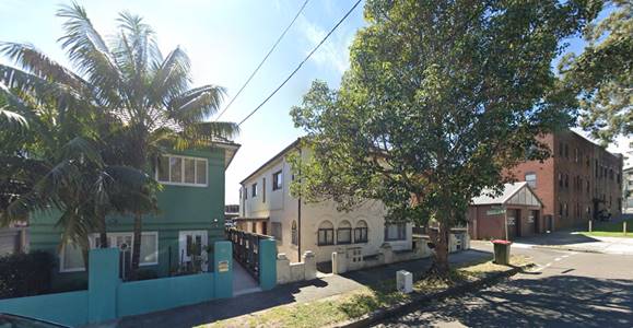
Photo of subject site and adjoining developments – subject site in middle, at right is Hooper Lane and beyond is No. 91 Gilderthorpe Avenue.
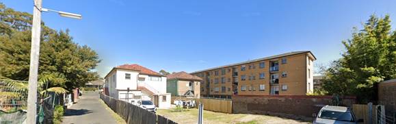
Photo of subject at rear showing Hooper Lane at left, at right of subject site (light coloured building) is No. 87 Gilderthorpe Avenue and further right (westward) is No. 85 Gilderthorpe Avenue which contains a four storey RFB.
The adjoining site to the west shown at right of the subject site in photo above is known as No. 87 Gilderthorpe Avenue and contains a three storey dual occupancy with ground level 5 car garaging. The opposite side of Hooper Lane is the rear of properties fronting Carrington Road containing predoiminately outbuildings and open car parking. The site and surrounding area are zoned R3 medium density residential under the Randwick Local Environmental Plan (RLEP) allowing for a height of 12m and density of 0.9:1. A heritage item is located approximately 25m to the west within a part of the site at No. 81-83 Gilderthorpe Avenue. An areial view of the site and surounding area is shown in image below.
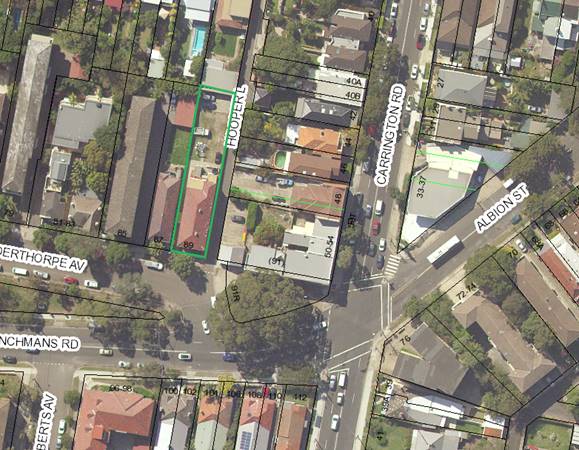
Aerial view of subject site and surrounding area.
3. Relevant history
No relevant history
4. Proposal
The amended proposal seeks development consent for demolition of existing building and construction of a new 3 storey residential flat building containing 9 units (3 x 1 bedroom and 6 x 3 bedroom) with basement parking for 12 vehicles and associated landscaping works and includes 43.5% (total floor area of 383.7m2 out of the proposed 880.72m2) of the total GFA as Affordable Housing comprising units 1, 2, 3, 5 & 8.
NB: the proposal was amended by converting originally proposed 3 x 2-berdroom units into 3 x 1-bedroom units in the middle of the building.
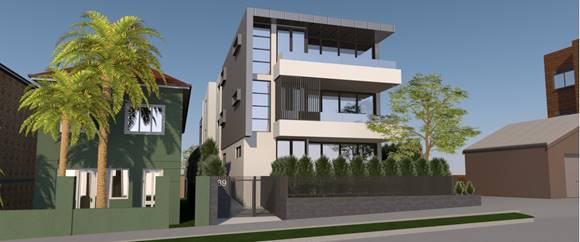
3D image of proposal as viewed from Gilderthorpe Avenue (Ref: Applicants response to RFI).
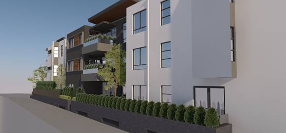
3D image of proposal as viewed from Hooper Lane (Ref: Applicants response to RFI).
Amended plans:
The proposed development as describe above represents the development as amended. The particular amendments made to the application include:
· Secondary setback increased by way of increasing the stepped in building elements in the middle floor plate resulting in the replacement of the originally proposed 2-bed apartments into 1-bed apartments reducing the GFA across the site. Replace hard surface patio areas with landscaping.
· Western elevation: increased stepped in laundries
· Engineering issues have been addressed by amendments that include widening of the access driveway, amended ramping grades, and compliance with Australian standards for parking spaces. Addition of one motorcycle space and 6 bicycle spaces, installation of a Traffic lighting system to minimise conflict between entering and exiting the basement through Hooper Lane.
· Reduction in the height of the building by way of reducing the length of the skillion roof.
· Nominated the units to be allocated as affordable housing – Units 1, 2, 3, 5 and 8
· Schedule of storage areas provided throughout the development.
· Provided western side fencing to address height and privacy impacts (subject of further conditioning)
5. Notification
The owners of adjoining and likely affected neighbouring properties were notified of the proposed development in accordance with the Randwick Comprehensive DCP 2013. The following submissions were received as a result of the notification process:
· 91 Gilderthorpe Avenue, Randwick
· 44 Carrington Road, Randwick
· 46 Carrington Road, Randwick
|
Issue |
Comment |
|
Overshadowing and sunlight The proposed 10.5m wall height and building length has the potential to result in more shade and reduce sunlight to units 1, 2 & 5 of No. 91 Gilderthorpe Avenue.
We would like to see shadows during summer. |
The additional overshadowing to these units only occurs in the late afternoon with the majority of shadows occurring over the carparking hardstand areas in the rear of No. 91 Gilderthorpe Avenue. It is also noted overshadowing to either neighbour is not excessive due to the north south orientation of the site where shadows are shared between the eastern and western neighbours and not to the detriment of any single neighbour ensuring compliance with the relevant DCP provisions. The properties at No. 46 Carrington Road will still retain solar access on either side of the midday sun.
Summer shadow diagrams are not required as the winter solstice shadows provide an indication of the worst-case scenario and summer shadows will show less overshadowing of neighbouring properties. |
|
Privacy The bedrooms for units 1, 2 and 5 are within 20m of the proposal and have the potential to be adversely impacted by privacy. |
The proposed eastern windows and balconies are setback from the affected windows more than the 6m minimum setback control required by the ADG ensuring sufficient privacy protection. |
|
Traffic · We would like to see extra traffic control measures for Hooper Lane · Most people have more than 2 vehicles and may put pressure on traffic and parking in the area. · How will construction traffic be managed to ensure access to carparking areas for other properties along Hooper Lane
|
Additional traffic measures are not required as a result of the proposed development. Notwithstanding, the process for requesting additional traffic measures requires an expression of interest to be sent for consideration by Council’s Traffic Committee. The proposed parking complies with the SEPP ARH provisions. Construction traffic is managed by condition requiring a Construction Traffic Management Plan to be submitted to and approved by Council’s Traffic Engineer prior to a Construction Certificate being issued for the development. |
|
Views The proposed planting of Red Bloodwood (in the rear of the site) with a mature height of 10m has the potential to result in loss of City views from No. 5 & 6/91 Gilderthorpe Avenue. |
A condition is included requiring the Red Bloodwood trees to be replaced with a species that doesn’t attain a height of more than 3m at maturity. |
|
Character The proposed modern building will look out of place with the surrounding buildings in the area. |
Noted, however the area is in transition and the proposed contemporary design as amended inclusive of additional articulation is considered to compliment the character of the surrounding area. |
|
Driveway positioning and sightlines The car park exist/entry is inappropriate in relation to sightlines adversely impacting pedestrian and vehicle safety along Hooper Lane.
|
Council’s Development Engineer does not raise any objections with regards to amended plans addressing certain issues with regards to proposed installation of a Traffic Light system, increased width of the driveway improving maneuverability into and out of the driveway. |
|
Building ratio to Garden Ratio Concerned the building to Garden Ratio is over encroaching and would like a comparison with the average ratio in the immediate area. |
The proposal provides 41.29% landscaped open space which is well above the 30% minimum required under the SEPP ARH. Councils DCP namely Part C2 requires 50% and does not comply. The SEPP ARH provisions sit above the local DCP controls. The proposal provides 15.56% deep soil area which is compliant with the 15% minimum required under the SEPP ARH. The RDCP controls require 25% and as noted that SEPP ARH provisions override the local DCP provisions. The proposed developments density that is, FSR is greater than the maximum applicable to sites in the surrounding area. However, the greater FSR is permissible by the ARHSEPP, a higher order social planning policy that aims for greater housing stock of affordable rental housing in NSW. Despite the greater density, the proposed development is considered to sit comfortably within the site and has been accommodated by only minor variations to the applicable RDCP controls for external wall height, side setbacks and landscaped area is considered to be appropriately distributed on site such that it is consistent with and will contribute to the character of the area a key objective for landscaping under the SEPP ARH. |
5.1. Renotification
The amended plans represent a reduction in the scale of the devlepoment and were not required to be renotified pursuant to the Community Particupation Plan.
6. Relevant Environment Planning Instruments
6.1. SEPP (Affordable Rental Housing) 2009 (SEPP ARH)
Part 2 New affordable rental housing > Division 1 In-fill affordble housing development
The proposal seeks Affordable housing subject to the provisions in Part 2 Division 1 of the SEPP for in-fill affordable housing develpoment. The proposal as amended demonstrates compliance with the applicable provisions and objectives. See assessment in Appendix 2 and where relevant Discussion of key issues section of this report.
Part 3 Retention of Affordable Housing
The existing RFB is proposed to be demolished comprises 4 apartments that are not strata subdivided. Therefore, Part 3 of the SEPP ARH is applicable to determine whether the proposal will result in a reduction in affordable rental housing, and therefore whether a monetary contribution might be considered to substitute any loss pursuant to Clause 51 of the ARH SEPP. It is noted that this part of the SEPP remains applicable despite the proposal to provide 5 units as affordable housing, which will be kept in tenure for a period of 10 years in accordance with Part 1 of the SEPP ARH. See assessment in Appendix 2.
6.2. SEPP (Vegetation in Non-rural Areas) 2017
The Vegetation SEPP came into effect in NSW on 25 August 2017. The aims of the Vegetation SEPP are:
“(a) to protect the biodiversity values of trees and other vegetation in non-rural areas of the State, and
(b) to preserve the amenity of non-rural areas of the State through the preservation of trees and other vegetation.”
Assessing Officer’s Comment: Clause 7(1) requires a permit to be granted by the Council for the clearing of vegetation in non-rural areas (such as City of Randwick). Consent for the removal of vegetation within the site is not being sought under this DA. The site contains no significant vegetation, and the removal of limited insignificant vegetation on site has been assessed and supported by Council’s Landscape Officer (refer to Appendix 1). The proposed landscaping will increase and enhance the quality and amount of vegetation on site and biodiversity values.
6.3. SEPP No. 65 – Design Quality Residential Flat Buildings
The proposed development is for a new RFB that comprises 9 dwellings and is 3 storeys, therefore SEPP 65 applies.
Clause 28 (2) of SEPP 65 states:
(2) In determining a development application for consent to carry out development to which this Policy applies, a consent authority is to take into consideration (in addition to any other matters that are required to be, or may be, taken into consideration):
(a) the advice (if any) obtained from the design review panel, and
(b) the design quality of the development when evaluated in accordance with the design quality principles, and
(c) the Apartment Design Guide.
Assessing Officer’s Comment: The original development was referred to Council’s Design Excellence Panel (“DEP”) and the DEP advice has been considered (refer to Appendix 1). The amended drawings were not referred back to the DEP as they are considered to have satisfactorily addressed the DEP comments, subject to conditions. Therefore, the amended development is assessed as being in accordance with the design quality principles of SEPP 65.
An assessment has also been carried out against the design criteria of the Apartment Design Guide (“ADG”) (refer to Appendix 3). In summary, the development complies with the objectives of the ADG.
Clause 30 of SEPP 65 provides standards that cannot be used as grounds to refuse development consent, which include:
(1) If an application for the modification of a development consent or a development application for the carrying out of development to which this Policy applies satisfies the following design criteria, the consent authority must not refuse the application because of those matters:
(a) if the car parking for the building will be equal to, or greater than, the recommended minimum amount of car parking specified in Part 3J of the Apartment Design Guide,
Assessing officer’s comment: According to Council’s Development Engineer, the proposal provides the required number of parking spaces (refer to Appendix 1).
(b) if the internal area for each apartment will be equal to, or greater than, the recommended minimum internal area for the relevant apartment type specified in Part 4D of the Apartment Design Guide,
Assessing officer’s comment: All of the apartments have internal areas that comply with the ADG (refer to Appendix 3).
(c) if the ceiling heights for the building will be equal to, or greater than, the recommended minimum ceiling heights specified in Part 4C of the Apartment Design Guide.
Note. The Building Code of Australia specifies minimum ceiling heights for residential flat buildings.
Assessing officer’s comment: All units will be provided with 2.7m floor to ceiling heights, whilst the 3.05m floor to floor heights are less than 3.1m indicated in the ADG, it is considered that the variation is minor and the 2.7m floor to ceiling height is considered achievable across the majority of the proposed developments habitable floor area. The applicant has also provided the following dimension demonstrating the proposed development can achieve the minimum 2.7 metre ceiling height within the proposed 3.05 metre floor to floor dimensions as follows:
· Slab thickness: 200mm
· Suspended ceiling: 100mm
· Floor finish + acoustic underlay: 50mm
· Floor to U/S Ceiling: 2700mm
Notwithstanding, an appropriate condition is recommended to ensure compliance with this requirement.
(2) Development consent must not be granted if, in the opinion of the consent authority, the development or modification does not demonstrate that adequate regard has been given to:
(a) the design quality principles, and
(b) the objectives specified in the Apartment Design Guide for the relevant design criteria.
Assessing officer’s comment: Based on comments provided by Council’s DEP, adequate regard has been given to the SEPP 65 design quality principles and the ADG design criteria (refer to Appendix 1), and the Applicant has submitted a Design Verification Statement prepared by a qualified architect.
(3) To remove doubt:
(a) subclause (1) does not prevent a consent authority from refusing an application in relation to a matter not specified in subclause (1), including on the basis of subclause (2), and
(b) the design criteria specified in subclause (1) are standards to which section 79C (2) of the Act applies.
6.4. State Environmental Planning Policy (Building Sustainability Index: BASIX) 2004 (“BASIX SEPP”)
A satisfactory BASIX certificate has been submitted in accordance with the requirements of the BASIX SEPP.
6.5. SEPP 55 – Remediation of Land
The objectives of SEPP 55 are:
(1) The object of this Policy is to provide for a Statewide planning approach to the remediation of contaminated land.
(2) In particular, this Policy aims to promote the remediation of contaminated land for the purpose of reducing the risk of harm to human health or any other aspect of the environment:
(a) by specifying when consent is required, and when it is not required, for a remediation work, and
(b) by specifying certain considerations that are relevant in rezoning land and in determining development applications in general and development applications for consent to carry out a remediation work in particular, and
(c) by requiring that a remediation work meet certain standards and notification requirements.
Clause 7 of SEPP 55 requires the consent authority to consider whether the land is contaminated and whether the land is or can be made suitable for the purpose for which development is proposed.
The site is not identified in Council’s records as being contaminated and no inidcation of any potentially contaminating activities can be derived from the historical uses on site. Therefore, the site may be considered suitable for the proposed residential development.
6.6. Randwick Local Environmental Plan 2012 (LEP)
The site is zoned R3 under Randwick Local Environmental Plan 2012 and the proposal is permissible with consent.
The proposal is consistent with the specific objectives of the zone in that the proposed activity and built form will compliment and contribute to the character of the area and will not result in any significant or unreasonable adverse impacts on the amenity of neighbouring properties.
The following development standards in the RLEP 2012 apply to the proposal:
|
Clause |
Development Standard |
Proposal |
Compliance (Yes/No) |
|
Cl 4.4: Floor space ratio (max) |
0.9:1. Note: 0.435:1 Bonus FSR afforded under SEPP ARH to 1.335:1. See comments under compliance column and GFA does not include any car parking (including area used for car parking). |
1.297:1 |
Yes, subject to bonus FSR of 0.435:1 added to the 0.9:1 allowing for an FSR maximum of 1.335:1 under SEPP ARH part 2 Division 1 in-fill affordable housing provisions. |
|
Cl 4.3: Building height (max) |
12m |
11.48m (RL86.08-RL74.60 (200mm below underside of floor level of RL74.80) |
Yes |
6.6.1. Clause 5.10 - Heritage conservation
See referral Heritage Planner comments in Appendix 1 of this report. No objections to the proposal on heritage grounds pursuant to the objectives and consideration required under Clause 5.10 of the RLEP for Heritage Conservation.
6.6.2. Earthworks
The RLEP states that before granting development consent for earthworks (or for development involving ancillary earthworks), the consent authority must consider the following matters:
a. the likely disruption of, or any detrimental effect on, drainage patterns and soil stability in the locality of the development,
b. the effect of the development on the likely future use or redevelopment of the land,
c. the quality of the fill or the soil to be excavated, or both,
d. the effect of the development on the existing and likely amenity of adjoining properties,
e. the source of any fill material and the destination of any excavated material,
f. the likelihood of disturbing relics,
g. the proximity to, and potential for adverse impacts on, any waterway, drinking water catchment or environmentally sensitive area,
h. any appropriate measures proposed to avoid, minimise or mitigate the impacts of the development.
The proposed development shows excavation for the basement within 900mm of the sites boundaries to the east and west having the potential for adverse impacts on the soil stabliity of adjoining land. The applicant submitted a Geotechnical report indicating that works can be performed whilst supporting the adjoining land. Should consent be granted a condition is included requiring a report from a suitably qualified and experienced professional engineer which contains Geotechnical details that confirm the suitability and stability of the site for the development and relevant design and construction requirements to be implemented to ensure the stability and adequacy of the development and adjacent land to the satisfaction of the Certifier.
6.6.3. Stormwater Management
The RLEP states that development consent must not be granted to development on land to which this clause applies unless the consent authority is satisfied that the development:
a. is designed to maximise the use of water permeable surfaces on the land having regard to the soil characteristics affecting on-site infiltration of water, and
b. includes, if practicable, on-site stormwater retention for use as an alternative supply to mains water, groundwater or river water, and
c. avoids any significant adverse impacts of stormwater runoff on adjoining properties, native bushland and receiving waters, or if that impact cannot be reasonably avoided, minimises and mitigates the impact.
Appropriate conditions are included to ensure the drainage and stormwater is managed appropriately.
7. Development control plans and policies
7.1. Randwick Comprehensive DCP 2013
The DCP provisions are structured into two components: objectives and controls. The objectives provide the framework for assessment under each requirement and outline key outcomes that a development is expected to achieve. The controls contain both numerical standards and qualitative provisions. Any proposed variations from the controls may be considered only where the applicant successfully demonstrates that an alternative solution could result in a more desirable planning and urban design outcome.
The relevant provisions of the DCP are addressed in Appendix 4.
8. Environmental Assessment
The site has been inspected and the application has been assessed having regard to Section 4.15 of the Environmental Planning and Assessment Act, 1979, as amended.
|
Section 4.15 ‘Matters for Consideration’ |
Comments |
|
Section 4.15 (1)(a)(i) – Provisions of any environmental planning instrument |
See discussion in sections 6 & 7 and key issues below.
|
|
Section 4.15(1)(a)(ii) – Provisions of any draft environmental planning instrument |
Nil. |
|
Section 4.15(1)(a)(iii) – Provisions of any development control plan |
The proposal generally satisfies the objectives and controls of the Randwick Comprehensive DCP 2013. See table in Appendix 4 and the discussion in key issues below
|
|
Section 4.15(1)(a)(iiia) – Provisions of any Planning Agreement or draft Planning Agreement |
Not applicable. |
|
Section 4.15(1)(a)(iv) – Provisions of the regulations |
The relevant clauses of the Regulations have been satisfied. |
|
Section 4.15(1)(b) – The likely impacts of the development, including environmental impacts on the natural and built environment and social and economic impacts in the locality |
The environmental impacts of the proposed development on the natural and built environment have been addressed in this report.
The proposed development is consistent with the dominant character in the locality.
The proposal will not result in detrimental social or economic impacts on the locality. |
|
Section 4.15(1)(c) – The suitability of the site for the development |
The site is located in close proximity to local services and public transport. The site has sufficient area to accommodate the proposed land use and associated structures. Therefore, the site is considered suitable for the proposed development. |
|
Section 4.15(1)(d) – Any submissions made in accordance with the EP&A Act or EP&A Regulation
|
The issues raised in the submissions have been addressed in this report. |
|
Section 4.15(1)(e) – The public interest |
The proposal promotes the objectives of the zone and will not result in any significant adverse environmental, social or economic impacts on the locality. Accordingly, the proposal is considered to be in the public interest. |
8.1. Discussion of key issues
Character of local area (cl. 16A of SEPP ARH)
Division 1 of the SEPP contains provisions and development standards that apply to development for the purpose of a in-fill affordable housing which have been addressed in the most part in SEPP ARH Table in Appendix 2. Clause 16A of SEPP ARH specifies that ‘a consent authority must take into consideration whether the development is compatible with the character of the local area’.
An appropriate methodology in carrying out this character test is provided for in the Land and Environment Court planning principle that seeks to ascertain the compatibility of a proposal with the surrounding development. The key case cited in this character test is Project Venture Developments Pty Ltd v Pittwater Council [2005] NSWLEC 191 at 22-31. An outline of the test includes ascertaining the:
A. Identify the local context,
B. Compatibility of built form that is:
· Is the appearance of the proposal in harmony with surrounding development and the character of the area?
· What are the physical impacts of the proposal on the amenity of neighbouring properties having regard to visual amenity, privacy, overshadowing and views.
C. Compatibility of use.
A. Identify the local area (Context)
The extent of land use surrounding the subject site are predominately medium density residential within sites zoned R3 medium density residential. The immediate locality is occupied by a mix of low and medium density residential land uses with built form dominated by one, two and three storey buildings. The surrounding area can be considered to be in transition with the emerging character expected to contain higher densities in the R3 medium density zone.
B. Compatibility of built form:
The consent authority is required to take into consideration whether the design of the development is compatible with the character of the local area.
· Is the appearance of the proposal in harmony with surrounding development and the character of the area?
The proposal as amended is consistent with the streetscape character, presenting as a three-storey development well within the maximum height of buildings standard in the RLEP for R3 zone of the site and surrounding area.
Despite the bonus floor area afforded by the SEPP ARH – a higher order social planning policy that aims for greater housing stock of affordable rental housing in NSW, the proposed development as amended does not take up the full floor area bonus. The additional bonus floor area is accommodated by only minor variations to the applicable RDCP controls for external wall height, side setbacks and landscaped area in the RDCP. It is considered that the objectives of the RLEP and RDCP provisions will continue to be satisfied.
In terms of appearance, the proposal presents as a medium density form of development envisaged by the standards, sits comfortably within the site and the emerging character of the area zoned for medium density housing.
Overall, the proposed larger density is representative of a sustainable form of development, is socially beneficial providing additional affordable rental housing stock in NSW and is therefore considered to meet the character test.
The next consideration is are the physical impacts of the proposal on surrounding development acceptable?.
The physical impacts of the proposal on the amenity of neighbouring properties having regard to key aspects of visual amenity, privacy, overshadowing and views are assessed as follows:
Visual amenity
In terms of visual amenity, the proposed in-fill development will essentially read as a three-storey development when viewed from the street and surrounding properties. The proposal is consistent with the relevant built form standards for medium density residential development contained in the RLEP for height of buildings (12m). The proposed gross floor area (1.297:1) is also compliant with the bonus density/floor area afforded for this type of development under the SEPP ARH allowing for a maximum of 1.335:1. The proposal is also generally consistent with the provisions of the built form controls in the RDCP applicable to medium density and low-density residential dwellings and where non-compliance occurs such as with setback and external wall heights, the proposal is considered to satisfy the relevant objectives.
In particular regard to setbacks, the proposed setbacks mostly comply with the RDCP provisions except for western side setback of the central access core opposite No. 87 Gilderthorpe Avenue which proposes a 1.5m setback which is 500mm short of the 2m minimum under the RDCP. The proposed setback occurs over a small 7.68m opposite ground and first floor study room windows and rear balcony at No. 87 Gilderthorpe which are closer to the side boundary than the proposal ensuring fair and equitable access to natural light and fresh air.
In particular regard to external wall height, the proposal partially complies with the 10.5m maximum control in the RDCP with the prominent south eastern corner of Gilderthorpe Avenue and Hooper Lane the development will have a height of 10.32m and at the rear north-eastern corner fronting Hooper Lane it has a maximum height of 10.48m. The majority of non-compliance occur at the eastern side elevation where the external wall height measures 10.84m (RL85.15-RL74.31) to the lowest ground level adjacent. This exceedance is somewhat reconciled due to the existing natural falls in topography and the proposed scheme containing suitable articulation through stepped in elements of design limits the building depth along this part of the development to a short 7.67m. It is also important to note that on either side of this wall the building steps back 3.2m from the side boundary which is significantly greater than the 2m side setback control under the DCP.
In addition, the neighbouring development at No. 87 Gilderthorpe Avenue is largely underdeveloped, and it is considered without prejudice that it would be able to take advantage of its already shallow side setbacks on a narrow lot that is not subject to a minimum side setback control and further, this neighbour’s western side neighbour has an existing RFB that has a sizable 5m setback from its boundary.
Overall, with regards to external wall height, the proposal is considered to satisfy the following objectives in the DCP:
· To ensure development height establishes a suitable scale to the street and contributes to its character.
· To ensure development height does not cause unreasonable impacts upon the neighbouring dwellings in terms of overshadowing, view loss, privacy and visual amenity.
· To ensure the form and massing of development respect the topography of the site.
Overshadowing
The proposed development retains reasonable levels of solar access to the neighbouring properties and does not result in undue overshadowing of neighbouring properties by virtue of the north-south orientation of the site.
Privacy
The proposed western elevation contains highlight windows between 1.55m and 1.85m above internal floor level which generally complies with the RDCP controls requiring 1.6m sill heights for windows with an outlook into habitable room windows on the opposite side.
The eastern elevation contains conventional windows with lower sill heights and balconies. These face onto Hooper Lane and are considered to be suitably placed and separated from the neighbouring properties habitable room windows and principal areas of private open spaces.
Views
The proposed additions are not considered to result in any loss of high value views from neighbouring properties. It is noted an objection has been received by a neighbouring property at No. 5 & 6/91 Gilderthorpe Avenue with regards to the loss of city views as a result of the proposed red bloodwood trees in the rear yard whereby a condition is proposed requiring trees in this area to be no higher than 3m at maturity.
Within the above context, the proposed bulk and scale, subject to conditions, is compatible with the built form of the surrounding area. The design of the development is capable of co-existing in harmony with the existing built form of its surroundings by virtue of the proposed scale, number of storeys, roof form, setbacks and contemporary design and mix of external colours and materials.
C. Compatibility of use:
The proposed constitutes a permissible development and its residential use is representative of a compatible use in the local area in the R3 medium density residential zone. The necessity for affordable housing stock represents a socially benefit.
Overall having regard to context, compatibility of built form and uses, the proposal is considered to satisfy the character test requirements within Clause 16A of the SEPP ARH 2009.
9. Conclusion
That the application to demolish of existing building and construction of a new 3 storey residential flat building containing 9 units (4 x 1 bedroom and 6 x 3 bedroom) with basement parking for 12 vehicles and associated landscaping works (includes Affordable Housing component be approved (subject to conditions) for the following reasons:
· The proposal is consistent with the relevant objectives contained within the RLEP 2012 and the relevant requirements of the RDCP 2013
· The proposal is consistent with the specific objectives of the R3 zone in that it presents a bulk and scale that is generally consistent with that envisaged by the applicable standards that will contribute to the character of the area and not result in any adverse impacts on the residents.
· The scale and design of the proposal is considered to be suitable for the location and is compatible with the desired future character of the locality.
· The development enhances the visual quality of the public domain/streetscape
Appendix 1: Referrals
1. Internal referral comments:
1.1. Heritage planner
The site is occupied by a two storey Interwar residential flat building, somewhat altered including enclosure of recessed balconies and possible rendering and painting of face brickwork. To the west of the site a Victorian Gothic house at nos.81 – 83 Gilderthorpe Avenue is listed as a heritage item. Clause 5.10(4) of Randwick LEP 2012 requires council to consider the effect of a proposed development on the heritage significance of the heritage item.
The application proposes to replace the existing residential flat building with a new residential flat building comprising three storeys over basement car parking. The proposed development is separated from the adjacent heritage item and will not impact on its fabric, or views to or from it. The proposed development should be consistent with LEP and DCP controls for the site in order to minimise impact on the streetscape setting of the heritage item.
1.2. Development Engineer and Landscape Officer
An application has been received for the demolition of existing building and construction of a new 3 storey residential flat building containing 9 units (1 x 1 bedroom, 2 x 2 bedroom and 6 x 3 bedroom) with basement parking for 13 vehicles and associated landscaping works (includes Affordable Housing component)the above site.
This report is based on the following plans and documentation:
· Amended architectural plans by C.M Hairis Architects, rev C, dated 26/02/20, and stamped by Council 01/03/21;
· Statement of Environmental Effects by ABC Planning, dated June 2020;
· Detail & Level Survey by W.B Buxton, ref 204947, dated 24/04/20;
· Landscape Plan by Libby Burley, sheet 1, issue B, dated 26/02/21.
General Comments
No objections are raised to the proposal subject to the comments and conditions provided in this report.
Flooding Comments
The site lies within the catchment of the revised Kensington/Centennial Park flood study which does not indicate any significant flooding on the site other than very minor surface flows on the Gilderthorpe Avenue frontage during the 1 in 100yr event. The site has also not been tagged under Sec 10.7 of the Environmental Planning and Assessment Act 1979 as being subject to flood related development controls.
It is noted no significant flooding is apparent in hooper lane and the entrance to the basement will be satisfactory subject to a minor crest 150mm above gutter levels. The introduction of kerb and gutter in Hooper lane will also reduce any surface runoff from the road into the subject site.
Drainage Comments
The Planning Officer is advised that the submitted drainage plans should not be approved in conjunction with the DA, rather, the Development Engineer has included a number of conditions in this memo that relate to drainage design requirements. The applicant is required to submit detailed drainage plans to the Principal Certifier for approval prior to the issuing of a construction certificate.
Should the Stormwater be discharged to Council’s street gutter or underground drainage system, an onsite stormwater detention (OSD) system will be required for this development.
Parking Provision Comments
The Statement of Environmental Effects states that the development will include an Affordable housing component. Parking Requirements for the development have therefore been assessed as per the following applicable parking rates specified in the SEPP Affordable Housing B7 of Randwick Council’s Development Control Plan 2013.
· 0.5 spaces per 1 bedroom unit
· 1 space per 2-bedroom unit
· 1.5 spaces per 3-bedroom unit
· No requirement for visitor parking
The proposed 9 dwellings comprise of 3 x 1 bedroom, and 6 x 3-bedroom apartments.
Parking required under DCP = (3 x 0.5) + (6 X 1.5)
= 1.5 + 9.0
= 10.5
= say 11 spaces
Parking proposed = 12 spaces (complies)
The SEPP Affordable Housing is silent on requirements for visitor parking however under the DCP rate of 1 visitor space per 4 dwellings, the proposed development would require a minimum of 2 spaces. It is recommended but not essential the 12th space be dedicated as visitor parking.
Motorbike Parking
The SEPP is silent on Motorbike Parking for Infill Housing hence it is presumed the DCP applies which states motorbike parking is to be provided at 5% of the vehicle parking requirement.
Motorbike Parking Required = 0.05 x 12
= 0.6
= say 1 space
Motorbike Parking proposed = 1 space (complies)
Bicycle Parking
The SEPP is silent on bicycle Parking for infill Housing hence it is presumed the DCP applies which states for Flats/multi dwelling bicycle parking is to be provided at 1 space per 2 units plus 1 visitor space per 10 units.
Bicycle Parking Required = 9/2 + 9/10
= 4.5 + 0.9
= 5.4
= say 5 space
Bicycle Parking proposed = 4 spaces (shortfall of 1 space)
Provision for 1 additional bicycle space should be provided in any amended plans.
Carpark Layout
The vehicular access driveways, internal circulation ramps and the carpark areas, (including, but not limited to, the ramp grades, carpark layout and height clearances) are to be in accordance with the requirements of Australian Standard 2890.1:2004.
In this regard it is noted there are a number of non-compliance with the spaces adjacent to the basement wall being at the end of a blind aisle. AS 2890.1 requires an additional 1m spacing after the end of the last space & the basement wall. This has not been provided however in compensation the end carspaces and adjacent parking aisle width have been widened significantly although no report was produced by a traffic engineer to support the variation.
It was therefore necessary for the Development Engineer to undertake a analysis of swept paths. It appears to indicate that access into the end spaces is possible although manoeuvring room is limited or tight. The additional width in the spaces and aisle widths should therefore compensate for the non-compliance in the blind aisle requirement in this instance.
There was also concern raised on the 3m aisle width adjacent to carspace 7 & 4. To avoid conflict it is recommended a traffic light system be installed to manage flow. This has been conditioned.
Service Authority Comments
Undergrounding of site feed power lines
At the ordinary Council meeting on the 27th May 2014, it was resolved that;
Should a mains power distribution pole be located on the same side of the street and within 15m of the development site, the applicant must meet the full cost for Ausgrid to relocate the existing overhead power feed from the distribution pole in the street to the development site via an underground UGOH connection.
The subject is not located within 15m of a power pole on the same side of the street hence the above clause is not applicable.
Waste Management Comments
The applicant is required to submit to Council and have approved by Council’s Director Planning, a Waste Management Plan (WMP) detailing waste and recycling storage and disposal for the development site.
The plan shall detail the type and quantity of waste to be generated by the development; demolition waste; construction waste; materials to be re-used or recycled; facilities/procedures for the storage, collection recycling & disposal of waste and show how the on-going management of waste for the units will operate.
Comments on the number of Waste Bins
Appendix 3 in Part B6 of Council’s DCP specifies a waste bin requirement rate for residential flat buildings houses of 1 x 240L bin per 2 rooms for normal garbage and 1 x 240L bin per 2 rooms for recycling.
i.e., Garbage/recycling Bins Required = 5 normal + 5 recycling
There are no specific requirements for green waste in Part B6 of the DCP however Council has now introduced a Food Organic/garden organics collection service which will also divert some of the waste from the red bins.
Total Number of BINS required = 4(normal) + 5(recycling) + 1(FOGO)
= 10 x 240L BINS
Total Number of BINS provided = 10 bins (complies)
Tree Management Comments
The only vegetation that requires assessment for this application is a mature, 10m tall Lophostemon confertus (Brush Box) located on Councils public verge, centrally across the width of this site, of good health and fair condition, which is covered by the DCP, and is also part of an avenue planting, which as a group, are a main feature of the streetscape.
While there are no external works, protection measures and a bond still need to be imposed to prevent secondary damage from machinery, deliveries and similar, with relevant conditions and a bond imposed.
There is no vegetation within the subject site at all, and as the submitted Landscape Plans will drastically increase the amount of plant material and overall treatment at the site, which will improve amenity for occupants, conditions require its full implementation as part of any approval.
1.3. Design Excellence Panel
PANEL COMMENTS
This is the second time the panel has reviewed a proposal for this site, with the previous review in February 2019 (note this DA was withdrawn). Since that time a new architect has been appointed (CM Hairis Architects) and revised the design in response to the panel’s comments.
The key change in the proposal is the increase in floor space via the Affordable Housing SEPP, and relocation of the parking to a basement level, which ensures the proposal now sits below the height control. However, a number of issues arise from accommodating increased floor space (1.36:1) within the compliant envelope (12m). These are addressed in the report below.
Principle 1: Context and Neighbourhood Context
· The site is located at the corner of Gilderthorpe Avenue and Hooper Lane, which provides rear access to the residential and commercial properties fronting Carrington Street to the east. Immediately to the south of the site is Bieler Park, which fronts Frenchmans Road and defines the eastern extent of the local centre.
· The existing building is typical of this area of Randwick; two-storey inter-war walk-up block of flats with surface parking at the rear, accessed from Hooper Lane. The properties to the west along Gilderthorpe are predominately flat buildings, presenting their narrow frontage to the street and stretching north/south along the deep blocks.
· The area is well served by local bus services along Frenchmans and Carrington Roads, and a number of local centres within walking distance.
Principle 2: Scale and Built Form
· The proposal is being lodged under the Affordable Housing SEPP, accessing the 0.5:1 FSR bonus, over the current controls (0.9:1), to target a 1.4: FSR. The current proposal is 1.36:1, which is significantly greater than the 0.96:1 proposed in February 2019. Despite this increase in floor space the proposal sits within the 12m height controls, with 3-storeys sitting above a basement parking level.
· The outcome of the increased floor space sitting within the height control is a building that covers the majority of the site, with minimal setbacks to Hooper Lane (east), and a minimum setback at 1.45m to the neighbouring property (west). The 5m setback to Gilderthorpe Street reflects the prevailing setback of the neighbouring properties, however the balcony to Units 4 and 7 sit within this setback zone – the design should be amended to pull the entire southern elevation (including balconies) back to the 5m setback. This may require the loss of a bedroom to these units, noting Bed 3 is undersized.
· The rear setback features the basement parking entrance ramp and a landscaped area at the rear boundary, which is isolated from the building and would be better assigned to the ground floor Unit 3.
· Investigate the relocation of communal open space to the roof, accessible for all apartments and taking the reliance off the ground floor space, and local open spaces to support the open space needs of the development.
· The properties corner location provides justification for the reduced eastern setback to Hooper Lane; however, the amenity of the ground floor units needs careful consideration – see below. The western setback to No. 87 is largely supported, as only the core is less than 2m.
Comment: The front setback has not been altered maintaining a 3.5m setback for the balconies with the main building setback between 4.3m and 6m from the front boundary. The undersized bedrooms have been rectified as part of the amended scheme and now comply with the ADG controls. The slightly cantilevered balconies are not considered to result in any significant adverse impacts on the amenity of neighbouring properties or the character of the street.
Principle 3: Density
· The planning controls envisage this type of development (3-storey residential flat building) on the site, however, the exceedance in FSR is not adequately addressed in terms of the amenity to individual units and holistically across the site. This report includes a number of recommendations to address this point. However, the panel recognise that a reduction in yield (bedrooms) may be required to achieve these outcomes.
Comment: The amended plans include additional stepped in elements along both the eastern and western side elevations providing for greater articulation and in the same manner reducing the yield for the middle apartments from 2-bedders down to 1-bedders with study.
Principle 4: Sustainability
A number of recommendations in relation to proposal;
· If proposed, A/C units should be shown on the plans and supplemented by ceiling fans in bedrooms.
· Rainwater capture and reuse should be investigated for landscaping and toilet flushing
· Solar shading to all windows, including those on the eastern and western elevations, to reduce heat load
Comment: A condition is included requiring the AC condensers to be located in the basement. A rainwater tank is not required by BASIX.
Principle 5: Landscape
· A landscape plan by Zenith Landscape Design has been provided and includes primarily perimeter planting, with a number of features in the rear garden to support the communal use. Given the relative isolation of this rear space from the building, and its relationship with Unit 3, the panel suggests investigating this space be assigned to the ground floor unit.
· Communal open space can be provided at the roof level, supplementing the reallocation of the ground floor space and supporting the increased development proposed on the site under the AHSEPP. Given three units are south facing, the roof top space provides a valuable sunny location for residents, without relying on the local public open space.
· Deep soil calculations include two very small and compromised areas on the eastern and western boundary, which have limited scope to support the growth or a mature tree and should be discounted from the calculation.
Comment: The amended landscape plan shows more contiguous landscaped areas that will foster the growth of mature planting.
Principle 6: Amenity
· Shadow studies should be expanded to indicate the extent of shadows, particularly in relation to the public open space to the south – the current diagrams are cropped
· Drawings state that ‘all units receive more than 3 hours direct sunlight’, however, the Panel consider Units 1, 4 and 7 to receive no direct sunlight given their southern orientation. The splayed windows to the living rooms don’t provide adequate sunlight to support this statement.
Comment: The east facing windows further south of the splayed windows are considered to allow for solar access to the living rooms.
Principle 7: Safety
No comments in relation to safety.
Principle 8: Housing Diversity and Social Interaction
The proposal for increasing the number of dwellings on the site is broadly supported, however, the size and number of dwellings may need to be reduced to reflect the desired boundary setbacks – most notably the southern setback to Gilderthorpe Street.
The addition of the communal open space at the roof level will provide a valuable opportunity for social interaction and community-building away from the sensitive interfaces at ground with Unit 3.
Comment: The provision of communal open space on the roof is not supported by Council.
Principle 9: Aesthetics
· The panel broadly support the approach taken by the architect in breaking down the eastern elevation, where the full length of the building is most visible. The treatment of the southern elevation to Gilderthorpe and Bieler Park will be the most prominent perspective and visible from passing traffic along Frenchmans Road – how the proposed building sits within the streetscape and vistas from the public space should be considered carefully. This could be addressed through a streetscape elevation that features the neighbouring properties and renders that extend to include the local context. This analysis may reveal the visibility of the south-western corner, which features floor-to-floor windows to bedrooms (curtains likely to be drawn) and the value in extending the balconies to the full width of the southern elevation to provide greater privacy and continuity to the buildings western and eastern elevations.
Comment: The applicant submitted a 3D render of the project showing the adjoining developments and it is considered to show that the proposal will fit in with the character of the area and sit comfortably within the site and amongst the development in the surrounding area.
SUMMARY AND RECOMMENDATIONS
The Panel would like to see the revised design and the response to the points raised in this report, and other matters raised by Council.
Comment: It is considered that the applicant has addressed the key issues and the amended scheme represents a vast improvement to the visual scale of the development as its viewed from within the streetscape and neighbouring properties.
Appendix 2: ARH SEPP Part 2 Division 1 In-fill Affordable Housing
|
PART 2 – NEW AFFORDABLE RENTAL HOUSING Division 1 – In-fill Affordable Housing
|
|||
|
Clause |
Control |
Proposal
|
Compliance |
|
Clause 10 - Development to which Division applies |
(1) This Division applies to development for the purposes of dual occupancies, multi dwelling housing or residential flat buildings if:
(a) the development concerned is permitted with consent under another environmental planning instrument, and
(b) the development is on land that does not contain a heritage item that is identified in an environmental planning instrument, or an interim heritage order or on the State Heritage Register under the Heritage Act 1977.
(2) Despite subclause (1), this Division does not apply to development on land in the Sydney region unless all or part of the development is within an accessible area. |
The proposed RFB is permitted with consent in the R3 Medium Density Residential zone.
The site does not contain a heritage item.
The site is within an accessible location as a bus stops is located within 400m of the site. The bus stops are located approximately 90m and 104m from the subject site which are serviced regularly by the 313 bus routes. |
Complies |
|
Clause 13 - Floor space ratios |
(1) This clause applies to development to which this Division applies if the percentage of the gross floor area of the development that is to be used for the purposes of affordable housing is at least 20 per cent.
(2) The maximum floor space ratio for the development to which this clause applies is the existing maximum floor space ratio for any form of residential accommodation permitted on the land on which the development is to occur, plus:
(a) if the existing maximum floor space ratio is 2.5:1 or less:
(i) 0.5:1—if the percentage of the gross floor area of the development that is used for affordable housing is 50 per cent or higher. (ii) Y:1—if
the percentage of the gross floor area of the development that is used for
affordable housing is less than 50 per cent, where— AH is the percentage of the gross floor area of the development that is used for affordable housing. Y = AH ÷ 100 |
The total proposed GFA = 880.72m2. Total affordable housing GFA of Units 1, 2, 3, 5 and 8 = 383.74m2, which is 43.5% of the total GFA.
The existing max permissible FSR pursuant to the RLEP is 0.9:1. As the percentage of affordable housing is <50% of the total GFA, a bonus FSR of 0.435:1 applies, being 1.335:1 (or GFA of 906.2m2).
The proposed FSR = 1.297:1 (808.72m2) |
Complies |
|
Clause 14 - Standards that cannot be used to refuse consent |
(1) Site and solar access Requirements A consent authority must not refuse consent to development to which this Division applies on any of the following grounds:
(a) (Repealed)
(b) site area if the site area on which it is proposed to carry out the development is at least 450 square metres, |
The site area is 678.8m² |
Complies
|
|
(c) landscaped area if:
(i) in the case of a development application made by a social housing provider—at least 35 square metres of landscaped area per dwelling is provided, or (ii) in any other case—at least 30 per cent of the site area is to be landscaped, |
The proposed landscaped area is approximately 41.29% (or 280.29m2) of the site. |
Complies |
|
|
(d) deep soil zones if, in relation to that part of the site area (being the site, not only of that particular development, but also of any other associated development to which this Policy applies) that is not built on, paved or otherwise sealed:
(i) there is soil of a sufficient depth to support the growth of trees and shrubs on an area of not less than 15 per cent of the site area (the deep soil zone), and (ii) each area forming part of the deep soil zone has a minimum dimension of 3 metres, and (iii) if practicable, at least two-thirds of the deep soil zone is located at the rear of the site area, |
The proposed deep soil zone is 15.56% (or GFA of 105.59m2).
|
Complies |
|
|
(e) solar access if living rooms and private open spaces for a minimum of 70 per cent of the dwellings of the development receive a minimum of 2 hours direct sunlight between 9am and 3pm in mid-winter.
|
100% of units will receive at least 2 hours of solar access to living rooms and balconies between 9am and 3pm on 21 June with front and middle units receiving solar access in the morning up to just before 12noon and rear apartments receiving solar access through the day. |
Complies
|
|
|
(2) General A consent authority must not refuse consent to development to which this Division applies on any of the following grounds:
(a) parking if:
(i) in the case of a development application made by a social housing provider for development on land in an accessible area—at least 0.4 parking spaces are provided for each dwelling containing 1 bedroom, at least 0.5 parking spaces are provided for each dwelling containing 2 bedrooms and at least 1 parking space is provided for each dwelling containing 3 or more bedrooms, or (ii) in any other case—at least 0.5 parking spaces are provided for each dwelling containing 1 bedroom, at least 1 parking space is provided for each dwelling containing 2 bedrooms and at least 1.5 parking spaces are provided for each dwelling containing 3 or more bedrooms, |
|
Complies |
|
|
(b) dwelling size if each dwelling has a gross floor area of at least:
(i) 35 square metres in the case of a bedsitter or studio, or (ii) 50 square metres in the case of a dwelling having 1 bedroom, or (iii) 70 square metres in the case of a dwelling having 2 bedrooms, or (iv) 95 square metres in the case of a dwelling having 3 or more bedrooms.
(iii) An additional 5m2 is required for additional bathrooms. |
3 x 1-bedroom unit, 6 x 3-bedroom units are proposed.
12 car parking spaces are provided in the basement level
|
Refer to Development Engineers comments in Appendix 1. |
|
|
(3) A consent authority may consent to development to which this Division applies whether or not the development complies with the standards set out in subclause (1) or (2). |
The dwellings have the following gross floor area: · Unit 1 is a 3-bedroom apartment = 104.08m2 (Affordable) · Unit 2 is a 1-bedroom apartment = 54.56m2 (Affordable) · Unit 3 is a 3-bedroom apartment = 106.76m2 (Affordable) · Unit 4 is a 3-bedroom apartment = 105.15m2 · Unit 5 is a 1-bedroom apartment = 59.17m2 (Affordable) · Unit 6 is a 3-bedroom apartment = 111.23m2 · Unit 7 is a 3-bedroom apartment = 105.15m2 · Unit 8 is a 1-bedroom apartment = 59.17m2 (Affordable) · Unit 9 is a 3-bedroom apartment = 111.23m2 |
Complies |
|
|
Nothing in this Policy affects the application of State Environmental Planning Policy No 65—Design Quality of Residential Flat Development to any development to which this Division applies. |
|
Noted |
|
|
Clause 16 - Continued application of SEPP 65 |
A consent authority must not consent to development to which this Division applies unless it has taken into consideration whether the design of the development is compatible with the character of the local area. |
Noted. SEPP 65 applies to the development and an assessment is carried out against SEPP 65 in table further below. |
Noted |
|
Clause 16A - Character of local area |
(1) A consent authority must not consent to development to which this Division applies unless conditions are imposed by the consent authority to the effect that:
(a) for 10 years from the date of the issue of the occupation certificate:
(i) the dwellings proposed to be used for the purposes of affordable housing will be used for the purposes of affordable housing, and (j) all accommodation that is used for affordable housing will be managed by a registered community housing provider, and
a restriction will be registered, before the date of the issue of the occupation certificate, against the title of the property on which development is to be carried out, in accordance with section 88E of the Conveyancing Act 1919, that will ensure that the requirements of paragraph (a) are met. |
Refer to section 8.1 of this report which addresses this section of the SEPP. |
Complies |
|
Clause 17 - Must be used for affordable housing for 10 years |
(b) Land on which development has been carried out under this Division may be subdivided with the consent of the consent authority. |
Conditions will ensure compliance with this part. |
Complies subject to conditions. |
|
Clause 18 - Subdivision |
|
|
|
Part 3 Retention of affordable rental housing
The ARH SEPP defines a low-rental dwelling as follows:
low-rental dwelling means a dwelling that (at any time in the 5-year period prior to the lodgement of a development application to which this Part applies) was let at a rental not exceeding the median rental level for that time (as specified in the Rent and Sales Report) in relation to a dwelling of the same type, having the same number of bedrooms and located in the same local government area.
The Applicant identified the existing building, indicating there being a total of 2 x 2-bedroom and 2 x 3-bedroom units. Based on the size of the existing development on site, this is accepted as the total number of bedrooms.
The rent and sales report published by the Department of Human Services between March 2017 and June 2020 provides the following data for 2- and 3-bedroom units:
- 2-bedroom units = $650 - $550 (March 2017 - December 2020)
- 3-bedroom units = $920 - $710 (March 2017 – December 2020)
In response to Council’s request for additional information, the Applicant submitted tenancy rental receipt records for each of the units detailing the rent for each apartment since the date of acquisition of the property in April 2018 which is one year short of the five years identified in the SEPP ARH for this assessment. Notwithstanding, in that four-year period the rental figures have not increased signifying that it is unlikely that the rentals would have varied in the first year. The rental figures provided show the following:
· Unit 1: 2-bedroom apartment rented at $500.00 per week
· Unit 2: 3-bedroom apartment rented at 590.00 per week
· Unit 3: 2-bedroom apartment rented at:
o $450 per week between 6 April 2018 to 4 October 2018 and
o $400 per week from 10 October 2018 to 7 March 2021
· Unit 4: 3-bedroom apartment rented at $570.00 per week
Clause 50 (2) of the ARH SEPP states:
(2) In determining a development application referred to in subclause (1), the consent authority is to take into account the guidelines and each of the following:
(a) whether there is likely to be a reduction in affordable housing on the land to which the application relates,
Assessing Officer’s Comment: Based on the data submitted, it is concluded that there will be the reduction of 4 low-rental dwellings (10 bedrooms) as a result of the proposed DA.
(b) whether there is available sufficient comparable accommodation to satisfy the demand for such accommodation,
Assessing Officer’s Comment: Sufficient comparable accommodation is available. Refer to comment in response to clause (3) below.
(c) whether the development is likely to cause adverse social and economic effects on the general community,
Assessing Officer’s Comment: Subject to a condition to provide contributions for affordable housing, the development is not likely to cause adverse social and economic effects on the community. It is noted that whilst this part of the SEPP remains applicable, the proposal is seeking to provide 5 apartments (1, 2, 3, 5, & 8 – containing a total of 9 bedrooms across 2 x 3-bedroom and 3 x 1-bedroom apartments). These new apartments will be conditioned to be kept in tenure as low rental dwellings for a period of 10 years in accordance with Part 1 of the SEPP ARH.
(d) whether adequate arrangements have been made to assist the residents (if any) of the building likely to be displaced to find alternative comparable accommodation,
Assessing Officer’s Comment: A condition is recommended to ensure this occurs.
(e) the extent to which the development contributes to any cumulative loss of affordable housing in the local government area,
Assessing Officer’s Comment: Subject to a condition to provide contributions for affordable housing, the development will not contribute to a cumulative loss of affordable rental housing. In addition, the proposal is seeking affordable housing which will be kept in tenure for 10 years from the date of occupation
.
(f) the structural soundness of the building, the extent to which the building complies with any relevant fire safety requirements and the estimated cost of carrying out work necessary to ensure the structural soundness of the building and the compliance of the building with the fire safety requirements,
Assessing Officer’s Comment: The proposal seeks demolition.
(g) whether the imposition of a condition requiring the payment of a monetary contribution for the purposes of affordable housing would adequately mitigate the reduction of affordable housing resulting from the development,
Assessing Officer’s Comment: As the development will result in the reduction of 4 low-rental dwellings, a monetary contribution for the purposes of affordable housing is appropriate to mitigate the loss.
(h) in the case of a boarding house, the financial viability of the continued use of the boarding house.
(3) For the purposes of subclause (2) (b), sufficient comparable accommodation is conclusively taken to be not available if the average vacancy rate in private rental accommodation for Sydney as published monthly by the Real Estate Institute of New South Wales is, for the 3 months immediately preceding the date of lodgement of the development application, less than 3 per cent.
Assessing Officer’s Comment: The average vacancy rate for the 3 months immediately preceding the date of lodgement (being April, May and June 2019) is 3.23% based on the data published by the Real Estate Institute of New South Wale (ref: https://www.reinsw.com.au/REINSW_Docs/Vacancy%20Rates/2020/REINSW-Vacancy-Rate-Result-December-2019.pdf)
(4) For the purposes of subclause (2) (h), the continued use of a boarding house is financially viable if the rental yield of the boarding house determined under clause 51 (5) not less than 6 per cent.
Assessing Officer’s Comment: N/A
In accordance with Clause 51 of the ARH SEPP, a condition is therefore recommended to ensure affordable housing contributions are provided to offset the loss of the 4 low-rental units as follows:
![]()
where:
C is the contribution payable.
L is the total number of bedrooms in a low-rental dwelling and boarding rooms that will be lost by the proposed development.
Assessing Officer’s Comment: A total of 10 bedrooms will be lost, therefore L = 10.
R is the replacement cost calculated as the average value of the first quartile of sales of strata properties in the local government area in which the development is to take place, as specified in the 4 most recent editions of the Rent and Sales Report.
Assessing Officer’s Comment:
June 2019 = $745,000. March 2019 = $765,000. December 2018 = $750,000. September 2018 = $781,000. The average value therefore = $760,250.
Clause 51(2)(a) of the SEPP ARH requires the consent authority, when determining a DA referred to in Clause 50(1), is satisfied that the proposed development will or is likely to reduce the availability of affordable housing within the area. Given the proposal will provide a total of 9 bedrooms as affordable housing, it is therefore considered that the total net loss of bedrooms in the circumstances of the case would be one bedroom only. As such, the amount of the contribution is calculated to be 1 x $760,250 x 0.05 = $38,012.50.
Appendix 3: Compliance with ADG Design Criteria
Apartment Design Guide (ADG)
An assessment has been carried out in accordance with Part 3: Siting the Development and Part 4: Designing the Building of the Apartment Design Guide against the design criteria requirements. Any non-compliance to the design criteria includes a merit-based assessment as per the design guidance of the Apartment Design Guide.
|
Clause |
Requirement |
Proposal |
Compliance |
|
Part 3: Siting the Development |
|||
|
3A -1 |
Site Analysis |
||
|
Each element in the Site Analysis Checklist should be addressed. |
Site analysis satisfactory and addresses elements in the checklist. |
Yes |
|
|
3B-1 |
Orientation |
||
|
|
Buildings along the street frontage define the street, by facing it and incorporating direct access from the street (see figure 3B.1). |
No apartments have direct access from the street due to the 1m elevation above street level and the need to provide landscaping within the front setbacks. |
Yes |
|
Where the street frontage is to the east or west, rear buildings should be oriented to the north. |
NA |
||
|
Where the street frontage is to the north or south, overshadowing to the south should be minimised and buildings behind the street frontage should be oriented to the east and west. |
The site is north facing, and the southern side is a street frontage. The building takes advantage of the frontage to Hooper Lane. |
Yes |
|
|
3B-2 |
Orientation |
||
|
Living areas, private open space and communal open space should receive solar access in accordance with sections 3D Communal and public open space and 4A Solar and daylight access. |
Solar access requirements will be achieved for the development with 100% of the units receive solar access to living spaces and POS. |
Complies. |
|
|
Solar access to living rooms, balconies and private open spaces of neighbours should be considered. |
Adequate solar access is received to the living rooms and private open space of neighbouring properties.
On balance, the subject site and neighbouring sites will receive a reasonable level of solar access to their windows, in particular the shadow diagrams demonstrate that the neighbouring northern windows will still receive the required 3 hours of solar access to their kitchens and rear yard area.
It should be noted that majority of the additional overshadowing impacts will be a result of the site orientation and any compliant built form will result in similar overshadowing impacts as presented for this proposal. |
Complies |
|
|
Where an adjoining property does not currently receive the required hours of solar access, the proposed building ensures solar access to neighbouring properties is not reduced by more than 20%. |
Adjoining neighbours receive three hours of solar access. |
Yes |
|
|
If the proposal will significantly reduce the solar access of neighbours, building separation should be increased beyond minimums contained in section 3F Visual privacy. |
Solar access remains satisfactory. |
N/A |
|
|
Overshadowing should be minimised to the south or downhill by increased upper-level setbacks. |
Increased upper-level setbacks are provided to the sides of the building partially in line with the non-compliant wall heights. |
Complies |
|
|
A minimum of 4 hours of solar access should be retained to solar collectors on neighbouring buildings. |
There are no solar collectors on adjoining properties. |
N/A |
|
|
3D-1 |
Communal and Public Open Space |
||
|
Communal open space has a minimum area equal to 25% of the site (see figure 3D.3) |
Minimum required for the site = 169.5m2
A communal area of 68.98m² is provided to the north at the rear of the site.
Given that the site is constrained in terms of orientation and bonus afforded by the SEPP ARH, this is considered an acceptable outcome.
The ADG design guidance does allow for smaller area of communal open space where the number of units in the scheme is relatively small and there are also opportunities for passive and active open spaces in the vicinity of the subject site. In this respect, the proposal does contain a relatively small number of units and it is considered that there are multiple areas of open space in the vicinity namely 56R Gilderthorpe Avenue opposite the site and also Centennial Park and Queens Park.
Also, some individual units are provided with larger private open space areas receive good solar access and daylight, which is considered an acceptable outcome. |
No however outcome is acceptable. |
|
|
Developments achieve a minimum of 50% direct sunlight to the principal usable part of the communal open space for a minimum of 2 hours between 9 am and 3 pm on 21 June (mid-winter). |
The communal open space is located to the rear northern part of the site and achieves compliance. |
Complies |
|
|
3E-1 |
Deep Soil Zones |
||
|
Deep soil zones are to meet the following requirements: Site Area: less than 650m2 = 7% of Site area. |
The proposed deep soil zone is 15.56%. |
Complies |
|
|
3F-1 |
Visual Privacy |
||
|
Separation between windows and balconies is provided to ensure visual privacy is achieved. Minimum required separation distances from buildings to the side and rear boundaries are as follows:
Up to 12m (4 storeys) – Habitable rooms and balconies = 6m, non-habitable rooms = 3m |
The setbacks are generally acceptable having regard to the RDCP provisions which are reflective of the existing and likely urban pattern of development in the medium density residential environment. |
Does not comply refer to comments at left. |
|
|
3J-1 |
Bicycle and Car Parking |
||
|
|
The minimum car parking requirement for residents and visitors is set out in the Guide to Traffic Generating Developments, or the car parking requirement prescribed by the relevant council, whichever is less.
The car parking needs for a development must be provided off street |
|
Refer to Appendix 1 – referral comments made by Council’s Development Engineers. |
|
Part 4: Designing the Building |
|||
|
4A |
Solar and Daylight Access |
||
|
Living rooms and private open spaces of at least 70% of apartments in a building receive a minimum of 2 hours direct sunlight between 9 am and 3 pm at mid winter in the Sydney Metropolitan Area and in the Newcastle and Wollongong local government areas |
All of the units achieve in excess of 2 hours solar access to part of their living area and POS. |
Complies |
|
|
A maximum of 15% of apartments in a building receive no direct sunlight between 9 am and 3 pm at mid-winter |
Complies |
||
|
4B |
Natural Ventilation |
||
|
|
At least 60% of apartments are naturally cross ventilated in the first nine storeys of the building. Apartments at ten storeys or greater are deemed to be cross ventilated only if any enclosure of the balconies at these levels allows adequate natural ventilation and cannot be fully enclosed |
All apartments are naturally cross-ventilated. |
Complies |
|
4C |
Ceiling Heights |
||
|
Measured from finished floor level to finished ceiling level, minimum ceiling heights are: Habitable Rooms – 2.7m Non-habitable – 2.4m |
A 2.7m floor to ceiling heights for habitable rooms is indicated in the SEE and is reflected on the sections provided. |
Complies |
|
|
4D |
Apartment Size and Layout |
||
|
Apartments are required to have the following minimum internal areas: Studio - 35m2 1 bedroom - 50m2 2 bedroom - 70m2 3 bedroom - 90m2
The minimum internal areas include only one bathroom. Additional bathrooms increase the minimum internal area by 5m2 each |
The dwellings have the following internal areas:
The dwellings have the following gross floor area: · Unit 1 is a 3-bedroom apartment = 104.08m2 (Affordable) · Unit 2 is a 1-bedroom apartment = 54.56m2 (Affordable) · Unit 3 is a 3-bedroom apartment = 106.76m2 (Affordable) · Unit 4 is a 3-bedroom apartment = 105.15m2 · Unit 5 is a 1-bedroom apartment = 59.17m2 (Affordable) · Unit 6 is a 3-bedroom apartment = 111.23m2 · Unit 7 is a 3-bedroom apartment = 105.15m2 · Unit 8 is a 1-bedroom apartment = 59.17m2 (Affordable) · Unit 9 is a 3-bedroom apartment = 111.23m2
|
Complies |
|
|
Every habitable room must have a window in an external wall with a total minimum glass area of not less than 10% of the floor area of the room. Daylight and air may not be borrowed from other rooms |
All habitable rooms comprise of a window opening for the purposes of light and will not have an area less than 10% of the floor area of the room. For the purposes of ventilation all apartments have multiple aspects. |
Complies |
|
|
Habitable room depths are limited to a maximum of 2.5 x the ceiling height |
All habitable room depths are within the maximum limit. |
Complies |
|
|
In open plan layouts (where the living, dining and kitchen are combined) the maximum habitable room depth is 8m from a window |
Open plan layouts are located within an 8 metres depth of a window. |
Complies |
|
|
Master bedrooms have a minimum area of 10m2 and other bedrooms 9m2 (excluding wardrobe space |
Bedrooms will achieve minimum area requirements. Note: bedroom sizes and dimensions increased in amened plans to comply. |
Complies |
|
|
Bedrooms have a minimum dimension of 3m (excluding wardrobe space |
All bedrooms have a minimum dimension of 3m. |
Complies |
|
|
Living rooms or combined living/dining rooms have a minimum width of: • 3.6m for studio and 1-bedroom apartments • 4m for 2- and 3-bedroom apartments |
The dimensions are greater than the minimum width requirement. |
Complies |
|
|
4E |
Apartment Size and Layout |
||
|
All apartments are required to have primary balconies as follows: Studio apartments 4m2 1-bedroom apartments 8m2 2m dim. 3-bedroom apartments 12m2 2.4m dim.
The minimum balcony depth to be counted as contributing to the balcony area is 1m |
All the private open space areas are adequate and are well above the minimum requirement. |
Complies |
|
|
For apartments at ground level or on a podium or similar structure, a private open space is provided instead of a balcony. It must have a minimum area of 15m2 and a minimum depth of 3m |
The ground floor apartment at the front has a courtyard area that’s well in excess of 15m2. Other apartments at ground level don’t have a courtyard due to the competing concerns of a secondary frontage setback allowance and the bonus FSR afforded under the SEPP ARH. |
Partial compliance – see comment at left. |
|
|
4F |
Common Circulation and Spaces |
||
|
The maximum number of apartments off a circulation core on a single level is eight |
The core provides entry to a maximum of 3 apartments. |
Complies |
|
|
4G |
Storage |
||
|
In addition to storage in kitchens, bathrooms and bedrooms, the following storage is provided:
Studio apartments 4m3 1 bedroom apartments 6m3 2 bedroom apartments 8m3 3+ bedroom apartments 10m3
At least 50% of the required storage is to be located within the apartment |
Unit 1: Requires 10m3 - 10.5m3 Unit 2: Requires 6m3 - 8.5m3 Unit 3: Requires 10m3 - 14.5m3 Unit 4: Requires 10m3 - 15.5m3 Unit 5: Requires 6m3 - 8m3 Unit 6: Requires 10m3 – 13.3m3 Unit 7: Requires 10m3 - 15.5m3 Unit 8: Requires 6m3 – 7.7m3 Unit 9: Requires 10m3 – 17.2m3 |
Complies |
|
Appendix 4: DCP Compliance Table
It is noted that Clause 6 of SEPP 65 refers to Parts 3 and 4 of the ADG and requires:
(1) This clause applies in respect of the objectives, design criteria and design guidance set out in Parts 3 and 4 of the Apartment Design Guide for the following:
(a) visual privacy,
(b) solar and daylight access,
(c) common circulation and spaces,
(d) apartment size and layout,
(e) ceiling heights,
(f) private open space and balconies,
(g) natural ventilation,
(h) storage.
(2) If a development control plan contains provisions that specify requirements, standards or controls in relation to a matter to which this clause applies, those provisions are of no effect.
(3) This clause applies regardless of when the development control plan was made.
Therefore, where the RDCP provides controls in relation to (1), refer to Appendix 3 for the ADG design criteria assessment.
The relevant provisions of the DCP are addressed below.
|
DCP Clause |
Control |
Proposal |
Compliance |
|
C2 |
Medium Density Residential |
||
|
2.2 |
Landscaped open space and deep soil area |
||
|
2.2.1 |
Landscaped open space |
||
|
|
A minimum of 50% of the site area (339.4m2) is to be landscaped open space. |
The proposed landscaped area is approximately 41.29% (280.29m2) of the site. |
Does not comply see comment below. |
|
|
Comment:
|
||
|
2.2.2 |
Deep soil area |
||
|
|
(i) A minimum of 25% of the site area (110.85m2) should incorporate deep soil areas sufficient in size and dimensions to accommodate trees and significant planting. (ii) Deep soil areas must be located at ground level, be permeable, capable for the growth of vegetation and large trees and must not be built upon, occupied by spa or swimming pools or covered by impervious surfaces such as concrete, decks, terraces, outbuildings or other structures. (iii) Deep soil areas are to have soft landscaping comprising a variety of trees, shrubs and understorey planting. (iv) Deep soil areas cannot be located on structures or facilities such as basements, retaining walls, floor slabs, rainwater tanks or in planter boxes. (v) Deep soil zones shall be contiguous with the deep soil zones of adjacent properties. |
15.85% (105.59m2). It is noted that the SEPP ARH housing requires only 15% and the ADG requires 7% deep soil.
Engineering comments at Appendix 1 requires on site stormwater detention and is conditioned within the consent. |
Does not comply, however, the variation is supported as it will meet the objectives of the control, and the requirements under the SEPP ARH and ADG. |
|
2.3 |
Private and communal open space |
||
|
2.3.1 |
Private open space |
||
|
|
Private open space is to be: (i) Directly accessible from the living area of the dwelling. (ii) Open to a northerly aspect where possible so as to maximise solar access. (iii) Be designed to provide adequate privacy for residents and where possible can also contribute to passive surveillance of common areas. For residential flat buildings: (vi) Each dwelling has access to an area of private open space in the form of a courtyard, balcony, deck or roof garden, accessible from with the dwelling. (vii) Private open space for apartments has a minimum area of 8m2 and a minimum dimension of 2m. |
All units have direct access from the living area and where possible have a northerly aspect to maximise solar access.
The POS complies with the minimum requirements.
|
Complies. |
|
2.3.2 |
Communal open space |
|
|
|
|
Communal open space for residential flat building is to be: (a) Of a sufficient contiguous area, and not divided up for allocation to individual units. (b) Designed for passive surveillance. (c) Well oriented with a preferred northerly aspect to maximise solar access. (d) adequately landscaped for privacy screening and visual amenity. (e) Designed for a variety of recreation uses and incorporate recreation facilities such as playground equipment, seating and shade structures. |
Communal open space is provided at the northern rear of the site and has an area of 68.98m2. |
Complies with the objectives of the control.
|
|
3 |
Building Envelope |
||
|
3.1 |
Floor space ratio |
||
|
|
1.335:1 required by the combined maximum permitted under the LEP and bonus under the ARH SEPP. |
1.297:1 |
Complies |
|
3.2 |
Building height |
||
|
|
12m required by the LEP. |
11.48m |
Complies |
|
3.3 |
Building depth |
||
|
|
For residential flat buildings, the preferred maximum building depth (from window-to-window line) is between 10m and 14m. Any greater depth must demonstrate that the design solution provides good internal amenity such as via cross-over, double-height or corner dwellings / units.
|
Building / apartment depths comply with the ADG limiting maximum glass line to glass line to 18m length for apartments for purpose of ventilation which takes precedence over the RDCP for this development standard (refer to ADG assessment in Appendix 3).
The proposal also complies with the minimum depth requirements in the DCP. |
Complies. |
|
3.4 |
Setbacks |
||
|
3.4.1 |
Front setback (i) The front setback on the primary and secondary property frontages must be consistent with the prevailing setback line along the street. Notwithstanding the above, the front setback generally must be no less than 3m in all circumstances to allow for suitable landscaped areas to building entries. (ii) Where a development is proposed in an area identified as being under transition in the site analysis, the front setback will be determined on a merit basis. (iii) The front setback areas must be free of structures, such as swimming pools, above-ground rainwater tanks and outbuildings. (iv) The entire front setback must incorporate landscape planting, with the exception of driveways and pathways. |
The proposed front setback is between 4.8m and 6m from the front boundary and considered to be consistent with the predominant setback of neighbouring properties.
The secondary setback is sited further from the Hooper Lane frontage than the predominant secondary side setback informed by No. 55 Hooper Street and other corner lots alongside laneways in the area. |
Complies. |
|
3.4.2 |
Side setback |
||
|
|
Residential flat building (i) Comply with the minimum side setback requirements stated below:
- Lots with a site frontage width >12m and <14m: 2m side setback applies
(ii) Incorporate additional side setbacks to the building over and above the above minimum standards, in order to:
- Create articulations to the building facades. - Reserve open space areas and provide opportunities for landscaping. - Provide building separation. - Improve visual amenity and outlook from the development and adjoining residences. - Provide visual and acoustic privacy for the development and the adjoining residences. - Ensure solar access and natural ventilation for the development and the adjoining residences. |
The site frontage width is 12.19m, and therefore a 2m side setback applies.
The proposal complies with the side setback providing 2.05m from the western side boundary except for the access core in the middle of the site.
Greater side setback than the minimum is provided at the western side including those stepped in building elements.
|
Partial compliance. Refer to character assessment in the Discussion of Key Issues section above.
|
|
|
(iii) A fire protection statement must be submitted where windows are proposed on the external walls of a residential flat building within 3m of the common boundaries. The statement must outline design and construction measures that will enable operation of the windows (where required) whilst still being capable of complying with the relevant provisions of the BCA. |
A standard condition will ensure compliance with the BCA is achieved. |
Conditioned to comply. |
|
3.4.3 |
Rear setback |
||
|
|
For residential flat buildings, provide a minimum rear setback of 15% (6.225m) of allotment depth or 5m, whichever is the greater. |
For an allotment depth of 55.69m, a rear setback of 8.35m applies to the site.
The proposal provides a 9m rear setback. |
Complies. |
|
4 |
Building Design |
||
|
4.1 |
Building façade |
||
|
|
(i) Buildings must be designed to address all street and laneway frontages. (ii) Buildings must be oriented so that the front wall alignments are parallel with the street property boundary or the street layout. (iii) Articulate facades to reflect the function of the building, present a human scale, and contribute to the proportions and visual character of the street. (iv) Avoid massive or continuous unrelieved blank walls. This may be achieved by dividing building elevations into sections, bays or modules of not more than 10m in length and stagger the wall planes. |
The front façade is well articulated and will present well to the street and surrounding properties with balconies, recessed and projecting architectural elements and a change in building materials.
The western side elevation contains walls at the front and rear ends that marginally exceed the 10m maximum as a result of glade walls at the ends of each floor plate to provide improved privacy protection. The minor encroachments aren’t considered to create any significant adverse visual amenity impacts when viewed from neighbouring properties due to the lightweight materials and fenestration within the scheme inclusive of stepped in elements and wall lengths well below the 10m. The eastern elevation contains pop out windows that provide visual relief to the scheme and present suitable articulation inclusive of the larger window openings and balconies.
|
Partial compliance, see comments at left.
|
|
4.2 |
Roof design |
||
|
|
(i) Design the roof form, in terms of massing, pitch, profile and silhouette to relate to the three-dimensional form (size and scale) and façade composition of the building. (ii) Design the roof form to respond to the orientation of the site, such as eaves and skillion roofs to respond to sun access. (iii) Use a similar roof pitch to adjacent buildings, particularly if there is consistency of roof forms across the streetscape. (iv) Articulate or divide the mass of the roof structures on larger buildings into distinctive sections to minimise the visual bulk and relate to any context of similar building forms.
(v) Use clerestory windows and skylights to improve natural lighting and ventilation of internalised space on the top floor of a building where feasible. The location, layout, size and configuration of clerestory windows and skylights must be sympathetic to the overall design of the building and the streetscape.
(vi) Any services and equipment, such as plant, machinery, ventilation stacks, exhaust ducts, lift overrun and the like, must be contained within the roof form or screened behind parapet walls so that they are not readily visible from the public domain.
(vii) Terraces, decks or trafficable outdoor spaces on the roof may be considered only if: - There are no direct sightlines to the habitable room windows and private and communal open space of the adjoining residences. - The size and location of terrace or deck will not result in unreasonable noise impacts on the adjoining residences. - Any stairway and associated roof do not detract from the architectural character of the building, and are positioned to minimise direct and oblique views from the street. - Any shading devices, privacy screens and planters do not adversely increase the visual bulk of the building.
(viii) The provision of landscape planting on the roof (that is, “green roof”) is encouraged. Any green roof must be designed by a qualified landscape architect or designer with details shown on a landscape plan. |
The proposal has a predominately flat roof however a skillion in the middle provides some visual relief.
The proposed roof form integrates with the contemporary language across the scheme and is consistent with majority of the recently approved and constructed residential flat building within the area.
The proposed flat roof relates well to the size and scale / façade composition of the building and is an appropriate roof design that reduces bulk and scale in response to the topography and concerns related to visual amenity.
|
Complies |
|
4.3 |
Habitable roof space |
||
|
|
Habitable roof space may be considered, provided it meets the following: - Optimises dwelling mix and layout, and assists to achieve dual aspect or cross over units with good natural ventilation. - Has a maximum floor space of 65% of the storey immediately below. - Wholly contain habitable areas within the roof space. - When viewed from the surrounding public and private domain, the roof form has the appearance of a roof. A continuous flat roof with habitable space within it will not satisfy this requirement. - Design windows to habitable roof space as an integrated element of the roof. - Submit computer generated perspectives or photomontages showing the front and rear elevations of the development. |
None proposed. |
N/A |
|
4.4 |
External wall height and ceiling height |
||
|
|
(ii) Where the site is subject to a 12m building height limit under the LEP, a maximum external wall height of 10.5m applies. |
The proposed development has a maximum external wall height of approximately 10.84m to the middle access core along the western elevation. |
Does not comply. Refer to Key Issues Section. |
|
|
(iii) The minimum ceiling height is to be 2.7m for all habitable rooms. |
2.7m |
Complies |
|
4.5 |
Pedestrian Entry |
||
|
|
(i) Separate and clearly distinguish between pedestrian pathways and vehicular access. |
Pedestrian pathways and vehicular access are clearly distinguished. |
Complies |
|
|
(ii) Present new development to the street in the following manner: - Locate building entries so that they relate to the pedestrian access network and desired lines. - Design the entry as a clearly identifiable element in the façade composition. - Integrate pedestrian access ramps into the overall building and landscape design. - For residential flat buildings, provide direct entries to the individual dwellings within a development from the street where possible. - Design mailboxes so that they are convenient to residents, do not clutter the appearance of the development at street frontage and are preferably integrated into a wall adjacent to the primary entry (and at 90 degrees to the street rather than along the front boundary). - Provide weather protection for building entries.
Postal services and mailboxes (i) Mailboxes are provided in accordance with the delivery requirements of Australia Post. (ii) A mailbox must clearly mark the street number of the dwelling that it serves. (iii) Design mail boxes to be convenient for residents and not to clutter the appearance of the development from the street. |
The building entries at the front and rear relate well to the pedestrian access network and are clearly defined.
The main front entry access to the dwellings is from the southern end of the site with direct access also to the communal area.
Mailboxes are provided to the front south western corner of the site.
|
Complies
|
|
4.6 |
Internal circulation |
||
|
|
(i) Enhance the amenity and safety of circulation spaces by: - Providing natural lighting and ventilation where possible. - Providing generous corridor widths at lobbies, foyers, lift doors and apartment entry doors. - Allowing adequate space for the movement of furniture. - Minimising corridor lengths to give short, clear sightlines. - Avoiding tight corners. - Articulating long corridors with a series of foyer areas, and/or providing windows along or at the end of the corridor. |
Building circulation requirements are provided in accordance with the ADG, which takes precedence over the RDCP for this development standard (refer to ADG assessment in Appendix 3). |
Complies with the ADG. |
|
|
(ii) Use multiple access cores to: - Maximise the number of pedestrian entries along a street for sites with wide frontages or corner sites. - Articulate the building façade. - Limit the number of dwelling units accessible off a single circulation core on a single level to 6 units. |
1 pedestrian access core is provided however there is an additional 2 access points to the basement. |
Complies |
|
|
(iii) Where apartments are arranged off a double-loaded corridor, limit the number of units accessible from a single core or to 8 units. |
Apartments are not provided off a double-loaded corridor. |
N/A |
|
4.7 |
Apartment layout |
||
|
|
(i) Maximise opportunities for natural lighting and ventilation through the following measures: - Providing corner, cross-over, cross-through and double-height maisonette / loft apartments. - Limiting the depth of single aspect apartments to a maximum of 6m. - Providing windows or skylights to kitchen, bathroom and laundry areas where possible. Providing at least 1 openable window (excluding skylight) opening to outdoor areas for all habitable rooms and limiting the use of borrowed light and ventilation. (ii) Design apartment layouts to accommodate flexible use of rooms and a variety of furniture arrangements. |
Apartment layouts are provided in accordance with the ADG, which takes precedence over the RDCP for this development standard (refer to ADG assessment in Appendix 3).
Notwithstanding, all apartments have dual aspects and are naturally cross ventilated and provided with adequate natural light. |
Complies with the ADG. |
|
|
(iii) Provide private open space in the form of a balcony, terrace or courtyard for each and every apartment unit in a development. (iv) Avoid locating the kitchen within the main circulation space of an apartment, such as hallway or entry. |
All apartments are provided with compliant POS that complies with the ADG, which takes precedence over the RDCP for this development standard (refer to ADG assessment in Appendix 3). |
Complies with the ADG. |
|
4.8 |
Balconies |
||
|
|
(i) Provide a primary balcony and/or private courtyard for all apartments with a minimum area of 8m2 and a minimum dimension of 2m and consider secondary balconies or terraces in larger apartments.
(i) Provide a primary terrace for all ground floor apartments with a minimum depth of 4m and minimum area of 12m2. All ground floor apartments are to have direct access to a terrace. |
All apartments are provided with compliant POS that complies with the ADG, which takes precedence over the RDCP for this development standard (refer to Appendix 3). |
Complies with the ADG. |
|
4.9 |
Colours, materials and finishes |
||
|
|
(i) Provide a schedule detailing the materials and finishes in the development application documentation and plans. (ii) The selection of colour and material palette must complement the character and style of the building. (iv) Use the following measures to complement façade articulation: - Changes of colours and surface texture - Inclusion of light weight materials to contrast with solid masonry surfaces - The use of natural stones is encouraged. (v) Avoid the following materials or treatment: - Reflective wall cladding, panels and tiles and roof sheeting - High reflective or mirror glass - Large expanses of glass or curtain wall that is not protected by sun shade devices - Large expanses of rendered masonry - Light colours or finishes where they may cause adverse glare or reflectivity impacts (vi) Use materials and details that are suitable for the local climatic conditions to properly withstand natural weathering, ageing and deterioration. (vii) Sandstone blocks in existing buildings or fences on the site must be recycled and re-used. |
The proposal presents as a modern apartment building utilising primarily render, neutral colours, lightweight metal recessive cladding and texture stone, with glass.
The proposed schedule of colours, finishes and materials are of dark and light neutral earthy tones.
A condition is included which requires a detailed colours, materials and finishes schedule to be provided to Council’s Manager of Development Assessment for approval. |
Conditioned to comply. |
|
4.12 |
Earthworks Excavation and backfilling |
||
|
|
(i) Any excavation and backfilling within the building footprints must be limited to 1m at any point on the allotment, unless it is demonstrated that the site gradient is too steep to reasonably construct a building within this extent of site modification. (ii) Any cut and fill outside the building footprints must take the form of terracing following the natural landform, in order to minimise the height or depth of earthworks at any point on the site. (iii) For sites with a significant slope, adopt a split-level design for buildings to minimise excavation and backfilling. |
Basement excavation within 900mm of the side boundaries.
A condition is included within the consent which requires a dilapidation report (incorporating photographs of relevant buildings) to be obtained from a Professional Engineer, detailing the current condition and status of all of the buildings and structures located upon all of the properties adjoining the subject site and any other property or public land which may be affected by the works. |
Complies with the objectives of the control and conditions are included to ensure compliance. |
|
|
Retaining walls (iv) Setback the outer edge of any excavation, piling or sub-surface walls a minimum of 900mm from the side and rear boundaries. (v) Step retaining walls in response to the natural landform to avoid creating monolithic structures visible from the neighbouring properties and the public domain. (vi) Where it is necessary to construct retaining walls at less than 900mm from the side or rear boundary due to site conditions, retaining walls must be stepped with each section not exceeding a maximum height of 2200mm, as measured from the ground level (existing). |
Retaining walls are proposed. The walls are limited in height and follow the contours of the land and are unlikely to affect any adjoining building or vegetation on the site. |
Complies |
|
5 |
Amenity |
||
|
5.1 |
Solar access and overshadowing |
||
|
|
Solar access for proposed development |
||
|
|
(i) Dwellings must receive a minimum of 3 hours sunlight in living areas and to at least 50% of the private open space between 8am and 4pm on 21 June. (ii) Living areas and private open spaces for at least 70% of dwellings within a residential flat building must provide direct sunlight for at least 3 hours between 8am and 4pm on 21 June. |
Apartments will receive adequate direct solar access that complies with the objectives of the ADG, which takes precedence over the RDCP for this development standard (refer to ADG assessment in Appendix 3). |
Complies with the objectives of the ADG. |
|
|
(iii) Limit the number of single-aspect apartments with a southerly aspect to a maximum of 10 percent of the total units within a residential flat building. |
No single aspect apartments are proposed. |
Complies |
|
|
(iv) Any variations from the minimum standard due to site constraints and orientation must demonstrate how solar access and energy efficiency is maximised. |
Complies |
|
|
|
Solar access for surrounding development |
||
|
|
(i) Living areas of neighbouring dwellings must receive a minimum of 3 hours access to direct sunlight to a part of a window between 8am and 4pm on 21 June. (ii) At least 50% of the landscaped areas of neighbouring dwellings must receive a minimum of 3 hours of direct sunlight to a part of a window between 8am and 4pm on 21 June. (iii) Where existing development currently receives less sunlight than this requirement, the new development is not to reduce this further. |
Based on the submitted shadow diagrams, additional overshadowing will occur to neighbouring properties to the east and west. |
Complies. |
|
5.2 |
Natural ventilation and energy efficiency |
||
|
|
(i) Provide daylight to internalised areas within each dwelling and any poorly lit habitable rooms via measures such as ventilated skylights, clerestory windows, fanlights above doorways and highlight windows in internal partition walls. |
All habitable rooms are provided with natural daylight via windows. |
Complies |
|
|
(ii) Sun shading devices appropriate to the orientation should be provided for the windows and glazed doors of the building. |
Appropriate sun shading devices have been provided. |
Complies |
|
|
(iii) All habitable rooms must incorporate windows opening to outdoor areas. The sole reliance on skylight or clerestory windows for natural lighting and ventilation is not acceptable. |
All habitable rooms are provided with window openings to outdoor areas. |
Complies |
|
|
(iv) All new residential units must be designed to provide natural ventilation to all habitable rooms. Mechanical ventilation must not be the sole means of ventilation to habitable rooms. |
All habitable rooms are capable of natural ventilation. |
Complies |
|
|
(v) A minimum of 90% of residential units should be naturally cross ventilated. In cases where residential units are not naturally cross ventilated, such as single aspect apartments, the installation of ceiling fans may be required. |
All apartments (100%) are cross-ventilated. |
Complies |
|
|
(vi) A minimum of 25% of kitchens within a development should have access to natural ventilation and be adjacent to openable windows. |
All kitchens (100%) have access to natural ventilation. |
Complies |
|
|
(vii) Developments, which seek to vary from the minimum standards, must demonstrate how natural ventilation can be satisfactorily achieved, particularly in relation to habitable rooms. |
N/A |
N/A |
|
5.3 |
Visual privacy |
||
|
|
(i) Locate windows and balconies of habitable rooms to minimise overlooking of windows or glassed doors in adjoining dwellings. (ii) Orient balconies to front and rear boundaries or courtyards as much as possible. Avoid orienting balconies to any habitable room windows on the side elevations of the adjoining residences. (iii) Orient buildings on narrow sites to the front and rear of the lot, utilising the street width and rear garden depth to increase the separation distance. (iv) Locate and design areas of private open space to ensure a high level of user privacy. Landscaping, screen planting, fences, shading devices and screens are used to prevent overlooking and improve privacy. (v) Incorporate materials and design of privacy screens including: - Translucent glazing - Fixed timber or metal slats - Fixed vertical louvres with the individual blades oriented away from the private open space or windows of the adjacent dwellings - Screen planting and planter boxes as a supplementary device for reinforcing privacy protection |
Visual privacy is provided in accordance with the ADG, which takes precedence over the RDCP for this development standard (refer to ADG assessment in Appendix 3). |
Subject to conditions will comply with the ADG. |
|
5.4 |
Acoustic privacy |
||
|
|
(i) Design the building and layout to minimise transmission of noise between buildings and dwellings. (ii) Separate “quiet areas” such as bedrooms from common recreation areas, parking areas, vehicle access ways and other noise generating activities. (iii) Utilise appropriate measures to maximise acoustic privacy such as: - Double glazing - Operable screened balconies - Walls to courtyards - Sealing of entry doors |
Acoustic privacy will be achieved within the apartments due to separation of quiet areas from noisy areas. |
Complies |
|
5.5 |
View sharing |
||
|
|
(i) The location and design of buildings must reasonably maintain existing view corridors and vistas to significant elements from the streets, public open spaces and neighbouring dwellings. (ii) In assessing potential view loss impacts on the neighbouring dwellings, retaining existing views from the living areas should be given a priority over those obtained from the bedrooms and non-habitable rooms. (iii) Where a design causes conflicts between retaining views for the public domain and private properties, priority must be given to view retention for the public domain. (iv) The design of fences and selection of plant species must minimise obstruction of views from the neighbouring residences and the public domain. (v) Adopt a balanced approach to privacy protection and view sharing, and avoid the creation of long and massive blade walls or screens that obstruct views from the neighbouring dwellings and the public domain. (vi) Clearly demonstrate any steps or measures adopted to mitigate potential view loss impacts in the development application. |
View sharing will be reasonably maintained. |
Complies subject to condition height of trees in the rear yard. |
|
5.6 |
Safety and security |
||
|
|
(i) Design buildings and spaces for safe and secure access to and within the development. |
Entry points to the building can be appropriately secured and will have clear lines of site. |
Complies |
|
|
(iii) For residential flat buildings, provide direct, secure access between the parking levels and the main lobby on the ground floor. |
Direct, secure access is provided. |
Complies |
|
|
(iv) Design window and door placement and operation to enable ventilation throughout the day and night without compromising security. The provision of natural ventilation to the interior space via balcony doors only, is deemed insufficient. |
All apartments are provided with openable habitable room windows that are capable of being secured. |
Complies |
|
|
(v) Avoid high walls and parking structures around buildings and open space areas which obstruct views into the development. |
No obstruction to lines of sight is proposed. |
Complies |
|
|
(vi) Resident car parking areas must be equipped with security grilles or doors. |
A security door to the basement access is proposed. |
Complies |
|
|
(vii) Control visitor entry to all units and internal common areas by intercom and remote locking systems. |
A condition is recommended to ensure compliance with this part. |
Complies, subject to condition. |
|
|
(viii) Provide adequate lighting for personal safety in common and access areas of the development. |
A condition is recommended to ensure compliance with this part. |
Complies, subject to condition. |
|
|
(ix) Improve opportunities for casual surveillance without compromising dwelling privacy by designing living areas with views over public spaces and communal areas, using bay windows which provide oblique views and casual views of common areas, lobbies / foyers, hallways, open space and car parks. |
Casual surveillance will be achieved to the street and communal areas from living rooms and private open spaces. |
Complies. |
|
|
(x) External lighting must be neither intrusive nor create a nuisance for nearby residents. |
A condition is recommended to ensure compliance with this part. |
Complies, subject to condition. |
|
|
(xi) Provide illumination for all building entries, pedestrian paths and communal open space within the development. |
A condition is recommended to ensure compliance with this part. |
Complies, subject to condition. |
|
6.1 |
Location |
||
|
|
(i) Car parking facilities must be accessed off rear lanes or secondary street frontages where available. |
Access to the basement car park is proposed from multiple points. |
Complies |
|
|
(ii) The location of car parking and access facilities must minimise the length of driveways and extent of impermeable surfaces within the site. |
The driveway length is minimised. |
Complies. |
|
|
(iii) Setback driveways a minimum of 1m from the side boundary. Provide landscape planting within the setback areas. |
The driveway is setback a minimum distance of 900mm from the side boundaries. |
Complies |
|
|
(iv) Entry to parking facilities off the rear lane must be setback a minimum of 1m from the lane boundary. |
There is no rear access. |
N/A |
|
|
(v) For residential flat buildings, comply with the following: (a) Car parking must be provided underground in a basement or semi-basement for new development. (b) On grade car park may be considered for sites potentially affected by flooding. In this scenario, the car park must be located on the side or rear of the allotment away from the primary street frontage. (c) Where rear lane or secondary street access is not available, the car park entry must be recessed behind the front façade alignment. In addition, the entry and driveway must be located towards the side and not centrally positioned across the street frontage. |
Parking is proposed within the basement. |
Complies |
|
6.2 |
Configuration |
||
|
|
(i) With the exception of hardstand car spaces and garages, all car parks must be designed to allow vehicles to enter and exit in a forward direction. |
The proposal is for off-street basement car parking accessed off Hooper Lane. Vehicles will be able to enter and exit the site in a forward direction via a turning circle within the basement. |
Complies |
|
|
(ii) For residential flat buildings, the maximum width of driveway is 6m. In addition, the width of driveway must be tapered towards the street boundary as much as possible. |
A suitably wide driveway and cross over is provided off Hooper Lane. |
Complies |
|
|
(iv) Provide basement or semi-basement car parking consistent with the following requirements: (a) Provide natural ventilation. (b) Integrate ventilation grills into the façade composition and landscape design. (c) The external enclosing walls of car park must not protrude above ground level (existing) by more than 1.2m. This control does not apply to sites affected by potential flooding. (d) Use landscaping to soften or screen any car park enclosing walls. (e) Provide safe and secure access for building users, including direct access to dwellings where possible. (f) Improve the appearance of car park entries and avoid a ‘back-of-house’ appearance by measures such as: - Installing security doors to avoid ‘black holes’ in the facades. - Returning the façade finishing materials into the car park entry recess to the extent visible from the street as a minimum. - Concealing service pipes and ducts within those areas of the car park that are visible from the public domain. |
The proposed basement complies with the development standard. |
Complies |
|
7 |
Fencing and Ancillary Development |
||
|
7.1 |
Fencing |
||
|
|
(i) Fences are constructed with durable materials that are suitable for their purpose and can properly withstand wear and tear and natural weathering. (ii) Sandstone fencing must not be rendered and painted. (iii) The following materials must not be used in fences: - Steel post and chain wire - Barbed wire or other dangerous materials (ii) Expansive surfaces of blank rendered masonry to street frontages must be avoided. |
Front and side fencing is proposed containing suitable materials |
Complies |
|
7.2 |
Front Fencing |
||
|
|
(i) The fence must align with the front property boundary or the predominant fence setback line along the street. (ii) The maximum height of front fencing is limited to 1200mm, as measured from the footpath level, with the solid portion not exceeding 600mm, except for piers. The maximum height of front fencing may be increased to 1800mm, provided the upper two-thirds are partially open, except for piers. (iii) Construct the non-solid portion of the fence with lightweight materials that are at least 30% open and evenly distributed along the full length of the fence. (iv) Solid front fence of up to 1800mm in height may be permitted in the following scenarios: - Front fence for sites facing arterial roads. - Fence on the secondary street frontage of corner allotments, which is behind the alignment of the primary street façade. Such solid fences must be articulated through a combination of materials, finishes and details, and/or incorporate landscaping, so as to avoid continuous blank walls. (v) The fence must incorporate stepping to follow any change in level along the street boundary. The height of the fence may exceed the aforementioned numerical requirement by a maximum of 150mm adjacent to any stepping. (vi) The preferred materials for front fences are natural stone, face bricks and timber. (vii) Gates must not open over public land. (viii) The fence adjacent to the driveway may be required to be splayed to ensure adequate sightlines for drivers and pedestrians. |
Front fencing is acceptable in height measuring between 1.3m and 1.8m from east to west with the higher west part of the fence responding to the lower natural fall in land level. The proposed solid bottom fence form is between 470mm and 840mm at the western end resulting in non-compliance with the maximum 600mm solid fence control. The variation is minor and as stated a natural response to the existing site conditions. The non-compliance maintains an appropriate scale from east to west and considered acceptable in the circumstances particularly given that the fence on top remains open in design ensuring the front fence does not dominate the front of the site.
|
Partial compliance, see comments at left.
|
|
7.3 |
Side and Rear Fencing |
||
|
|
(i) The maximum height of side, rear or common boundary fences is limited to 1800mm, as measured from the ground level (existing). For sloping sites, the fence must be stepped to follow the topography of the land, with each step not exceeding 2200mm above ground level (existing). (ii) In the scenario where there is significant level difference between the subject and adjoining allotments, the fencing height will be considered on merits. (iii) The side fence must be tapered down to match the height of the front fence once pasts the front façade alignment. (iv) Side or common boundary fences must be finished or treated on both sides. |
The proposed side boundary fence has a maximum height of between 3.32m and 3.37m (77.37-74.05/77.10-73.73) which is generally considered an excessively high fence adversely affecting their visual amenity. A difference in ground level between sites is evident and the ability to excavate further is limited due to the narrow site and access ramp requirements.
Notwithstanding the fence height is excessive and in order to minimise the massing of this fence required for privacy of the neighbours it is considered reasonable to require the lightweight component that sits above the solid masonry wall to be designed such that it is designed with louvres that are a minimum of 30% open and angled in such a fashion so as to the ensure no direct views into the habitable room windows opposite. This condition ensures the solid fence will have a height of between 2.3m and 2.62m (76.35-74.04/73.73) which is closer to the 2.2m DCP control ensuring no significant adverse visual amenity impacts on the neighbouring property. |
Does not comply, see comments at left indicating side boundary fence is subject to condition. |
|
7.6 |
Storage |
||
|
|
(i) The design of development must provide for readily accessible and separately contained storage areas for each dwelling. (ii) Storage facilities may be provided in basement or sub floor areas, or attached to garages. Where basement storage is provided, it should not compromise any natural ventilation in the car park, reduce sight lines or obstruct pedestrian access to the parked vehicles. (iii) In addition to kitchen cupboards and bedroom wardrobes, provide accessible storage facilities at the following rates: (a) Studio apartments – 6m3 (a) 1-bedroom apartments – 6m3 (b) 2-bedroom apartments – 8m3 (c) 3 plus bedroom apartments – 10m3 |
Storage is provided in accordance with the ADG, which takes precedence over the RDCP for this development standard (refer to ADG assessment in Appendix 3). |
Complies with ADG. |
|
7.7 |
Laundry facilities |
||
|
|
(i) Provide a retractable or demountable clothes line in the courtyard of each dwelling unit. |
Adequate clothes drying facilities are proposed for the Units. |
Complies |
|
|
(ii) Provide internal laundry for each dwelling unit. |
Each unit is provided with an internal laundry. |
Complies |
|
|
(iii) Provide a separate service balcony for clothes drying for dwelling units where possible. Where this is not feasible, reserve a space for clothes drying within the sole balcony and use suitable balustrades to screen it to avoid visual clutter. |
Sufficient area is available as part of the communal open space. |
Complies |
|
7.8 |
Air conditioning units: |
||
|
|
· Avoid installing within window frames. If installed in balconies, screen by suitable balustrades. · Air conditioning units must not be installed within window frames. |
The A/C units are not identified for the development. Therefore, a condition is included to ensure that the AC units are not located within balconies or the roof of the proposed development. |
Subject to condition. |
|
1.⇩ |
RLPP Develoment Consent Conditions DA/279/2020 - 89 Gilderthorpe Ave Randwick |
|
Responsible officer: Louis Coorey, Senior Environmental Planning Officer
File Reference: DA/279/2020
|
RLPP Develoment Consent Conditions DA/279/2020 - 89 Gilderthorpe Ave Randwick |
Attachment 1 |
|
Folder /DA No: |
DA/279/2020 |
|
Property: |
89 Gilderthorpe Avenue, RANDWICK NSW 2031 |
|
Proposal: |
Demolition of existing building and construction of a new 3 storey residential flat building containing 9 units (3 x 1 bedroom and 6 x 3 bedroom) with basement parking for 12 vehicles and associated landscaping works (includes Affordable Housing component) |
|
Recommendation: |
Approval |
Development Consent Conditions
GENERAL CONDITIONS
The development must be carried out in accordance with the following conditions of consent.
These conditions have been applied to satisfy the relevant requirements of the Environmental Planning & Assessment Act 1979, Environmental Planning & Assessment Regulation 2000 and to provide reasonable levels of environmental amenity.
Approved Plans & Supporting Documentation
1. The development must be implemented substantially in accordance with the plans and supporting documentation listed below and endorsed with Council’s approved stamp, except where amended by Council in red and/or by other conditions of this consent:
|
Plan |
Drawn by |
Dated |
|
01C Issue C |
C.M. Hairis Architects |
26/02/2020 |
|
02C Issue C |
C.M. Hairis Architects |
26/02/2020 |
|
03C Issue C |
C.M. Hairis Architects |
26/02/2020 |
|
04C Issue C |
C.M. Hairis Architects |
26/02/2020 |
|
05C Issue C |
C.M. Hairis Architects |
26/02/2020 |
|
06B Issue B |
C.M. Hairis Architects |
10/02/2020 |
|
09C Issue C |
C.M. Hairis Architects |
26/02/2020 |
|
Sht-1 Issue B |
Libby Birley Garden Design |
26/2/21 |
|
BASIX Certificate No. |
Dated |
|
1105997M |
2 June 2020 |
Amendment of Plans & Documentation
2. The approved plans and documents must be amended in accordance with the following requirements:
a. The slatted fencing along the western side boundary shall be constructed with fixed vertical or horizontal louvres with the individual blades angled and spaced appropriately to prevent overlooking into the private open space or windows of the adjacent dwellings.
b. The two (2) Red Bloodwood trees proposed in the rear yard shall be replaced with alternate species which does not exceed a mature height of 3m.
c. No air conditioning or plant and equipment other than photovoltaic cells are permitted on the roof.
d. All habitable rooms within each dwelling shall have a minimum ceiling height of 2,700mm. Details of compliance including (but not limited to) the reflected ceiling plans and detailed sections are to be submitted to and approved by Council’s Manager Development Assessment prior to the issue of Construction Certificate.
Intercom / Locking Systems
3. Control visitor entry to all units and internal common areas by intercom and remote locking systems.
Lighting
4. Adequate lighting for personal safety shall be provided in common and access areas including building entries and communal open space areas.
Loss of Affordable Rental Hosing Contribution
5. A monetary contribution of $38,012.50 for mitigating the loss of low-rental accommodation pursuant to Clause 51 of the SEPP Affordable Rental Housing (2009) shall be paid to Council in one complete payment prior to the demolition of the existing building. The contribution must be paid in cash and/or bank cheque.
The current tenants in Units 1, 2, 3 and 4 shall be:
i. Provided with a minimum of 3 months’ Notice to Vacate.
ii. Assisted to find alternative comparable accommodation. This shall include verified and genuine efforts in making enquiries with local real estate agents and or relevant community housing providers; and
iii. Provided with a $500 one-off payment to assist with relocation expenses.
The applicant shall inform the current tenants of Units 1, 2, 3 and 4 of this condition and documentary evidence shall be submitted to Council showing this prior to the issue of the Construction Certificate in accordance with Clause 50(2) of the SEPP Affordable Rental Housing 2009.
Affordable Rental Housing Component
6. Units 1, 2, 3, 5 and 8 shall be provided as affordable rental housing in accordance with the SEPP (ARH) 2009.
a. The dwellings to be used for the purposes of ‘affordable rental housing’, as per the provisions of the SEPP (ARH) 2009 shall be used as such for at least 10 years from the date of the issue of the Occupation Certificate.
b. The affordable rental housing component (secured for a minimum of 10 years) must be managed by a registered Community Housing Provider (CHP).
c. The CHP must ensure compliance with the occupant restriction and others provisions of the regulatory code established through regulations under the Housing Act 2001.
d. A restriction must be registered, before the date of the issue of the occupation certificate, against the title of the property, in accordance with Section 88E of the Conveyancing Act 1919 that will ensure that the requirements a. and b. are met and that the terms of restriction may not be varied without Council’s consent.
e. Prior to an Occupation Certificate being granted, evidence must be provided to Council demonstrating that the section 88E covenant has been registered on the title stating that the affordable rental housing component must be used for affordable rental housing and managed by a registered CHP.
REQUIREMENTS BEFORE A CONSTRUCTION CERTIFICATE CAN BE ISSUED
The following conditions of consent must be complied with before a ‘Construction Certificate’ is issued by either Randwick City Council or an Accredited Certifier. All necessary information to demonstrate compliance with the following conditions of consent must be included in the documentation for the construction certificate.
These conditions have been applied to satisfy the relevant requirements of the Environmental Planning & Assessment Act 1979, Environmental Planning & Assessment Regulation 2000, Council’s development consent conditions and to achieve reasonable levels of environmental amenity.
Consent Requirements
7. The requirements and amendments detailed in the ‘General Conditions’ must be complied with and be included in the construction certificate plans and associated documentation.
External Colours, Materials & Finishes
8. The colours, materials and finishes of the external surfaces to the building are to be compatible with the adjacent development to maintain the integrity and amenity of the building and the streetscape.
Details of the proposed colours, materials and textures (i.e. a schedule and brochure/s or sample board) are to be submitted to and approved by Council’s Manager Development Assessments prior to issuing a construction certificate for the development.
Section 7.12 Development Contributions
9. In accordance with Council’s Development Contributions Plan effective from 21 April 2015, based on the development cost of $2,717,650.32 the following applicable monetary levy must be paid to Council: $27,176.50.
The levy must be paid in cash, bank cheque or by credit card prior to a construction certificate being issued for the proposed development. The development is subject to an index to reflect quarterly variations in the Consumer Price Index (CPI) from the date of Council’s determination to the date of payment. Please contact Council on telephone 9093 6999 or 1300 722 542 for the indexed contribution amount prior to payment.
To calculate the indexed levy, the following formula must be used:
IDC = ODC x CP2/CP1
Where:
IDC = the indexed development cost
ODC = the original development cost determined by the Council
CP2 = the Consumer Price Index, All Groups, Sydney, as published by the ABS in respect of the quarter ending immediately prior to the date of payment
CP1 = the Consumer Price Index, All Groups, Sydney as published by the ABS in respect of the quarter ending immediately prior to the date of imposition of the condition requiring payment of the levy.
Council’s Development Contribution Plans may be inspected at the Customer Service Centre, Administrative Centre, 30 Frances Street, Randwick or at www.randwick.nsw.gov.au.
Compliance Fee
10. A development compliance and enforcement fee of : $2,717.65 shall be paid to Council in accordance with Council’s adopted Fees & Charges Pricing Policy, prior to the issue of a Construction Certificate for development.
Long Service Levy Payments
11. The required Long Service Levy payment, under the Building and Construction Industry Long Service Payments Act 1986, must be forwarded to the Long Service Levy Corporation or the Council, in accordance with Section 6.8 of the Environmental Planning & Assessment Act 1979.
At the time of this development consent, Long Service Levy payment is applicable on building work having a value of $25,000 or more, at the rate of 0.35% of the cost of the works.
The following conditions are applied to provide adequate security against damage to Council’s infrastructure:
Security Deposit
12. The following damage / civil works security deposit requirement must be complied with, as security for making good any damage caused to the roadway, footway, verge or any public place; and as security for completing any public work; and for remedying any defect on such public works, in accordance with section 80A(6) of the Environmental Planning and Assessment Act 1979:
· $13,000 - Damage / Civil Works Security Deposit
The damage/civil works security deposit may be provided by way of a cash or credit card payment and is refundable upon a satisfactory inspection by Council upon the completion of the civil works which confirms that there has been no damage to Council's infrastructure.
The owner/builder is also requested to advise Council in writing and/or photographs of any signs of existing damage to the Council roadway, footway, or verge prior to the commencement of any building/demolition works.
To obtain a refund of relevant deposits, a Security Deposit Refund Form is to be forwarded to Council’s Director of City Services upon issuing of an occupation certificate or completion of the civil works.
Sydney Water
13. All building, plumbing and drainage work must be carried out in accordance with the requirements of the Sydney Water Corporation.
The approved plans must be submitted to the Sydney Water Tap in™ online service, to determine whether the development will affect Sydney Water’s waste water and water mains, stormwater drains and/or easements, and if any further requirements need to be met.
The Tap in™ service provides 24/7 access to a range of services, including:
· Building plan approvals
· Connection and disconnection approvals
· Diagrams
· Trade waste approvals
· Pressure information
· Water meter installations
· Pressure boosting and pump approvals
· Change to an existing service or asset, e.g. relocating or moving an asset.
Sydney Water’s Tap in™ in online service is available at:
https://www.sydneywater.com.au/tapin
The Principal Certifier must ensure that the developer/owner has submitted the approved plans to Sydney Water Tap in online service.
Telecommunications infrastructure
14. Prior to the issue of a Construction Certificate in connection with this development, the developer (whether or not a constitutional corporation) is to provide evidence satisfactory to the Principal Certifier that arrangements have been made for:
(i) The installation of fibre-ready facilities to all individual lots and/or premises in a real estate development project so as to enable fibre to be readily connected to any premises that is being or may be constructed on those lots. Demonstrate that the carrier has confirmed in writing that they are satisfied that the fibre ready facilities are fit for purpose, and;
(ii) The provision of fixed-line telecommunications infrastructure in the fibre-ready facilities to all individual lots and/or premises in a real estate development project demonstrated through an agreement with a carrier.
NOTE: Real estate development project has the meanings given in section 372Q of the Telecommunications Act.
Street Tree Protection
15. In order to ensure retention of the Lophostemon confertus (Brush Box) that is located on Council’s Gilderthorpe Avenue verge, centrally across the width of this site in good health, the following measures are to be undertaken:
a. All documentation submitted for the Construction Certificate application must show its retention, along with the position and diameter of both its trunk and canopy.
b. Any excavations associated with the installation of new services, pipes, stormwater systems or similar over public property can only be located in line the sites side boundaries, both to minimise root damage as well as avoid future maintenance issues, with the Principal Certifier to ensure that all services plans are both prepared and then installed on-site to comply with this requirement.
c. Prior to the commencement of any site works, its trunk (as well as any lower growing branches where necessary) must be physically protected by wrapping layers of geo-textile, underfelt, carpet, hessian or similar, from ground level to a height of 2m, to which, 2m lengths of 50mm x 100mm hardwood timbers, spaced at 150mm centres shall be placed around its circumference, and are to be secured by 8 gauge wires or steel strapping at 300mm spacing. NO nailing to the trunk.
d. This protection must be installed prior to the commencement of demolition and construction works and shall remain in place until all works are completed, to which, signage containing the following words shall be clearly displayed and permanently attached: “TREE PROTECTION, DO NOT REMOVE".
e. The applicant is not authorised to perform any other works to this public tree, and must contact Council’s Landscape Development Officer on 9093-6613 should clearance pruning or similar be necessary. If approval is given, it can only be performed by Council, wholly at the applicants cost, and GIVING SIX WEEKS NOTICE, with payment for this to be received prior to pruning, and prior to any Occupation Certificate.
f. There is to be no storage of materials, machinery or site office/sheds, nor is cement to be mixed or chemicals spilt/disposed of and no stockpiling of soil or rubble around its trunk, with all Site Management Plans to acknowledge these requirements.
g. Where roots are encountered which are in direct conflict with any approved external civil works, they may be cut cleanly by hand (using only hand-held tools, not machinery), with the affected area to then be backfilled with clean site soil so that cut ends of roots are not left exposed to the atmosphere.
h. The Principal Certifier must ensure compliance with all of these requirements, both on the plans as well as on-site during the course of construction, and prior to any Occupation Certificate.
i. A refundable deposit in the form of cash, credit card or cheque for an amount of $2,000.00 must be paid at the Cashier on the Ground Floor of the Administrative Centre, prior to a Construction Certificate being issued for the development, in order to ensure compliance with the conditions listed in this consent, and ultimately, preservation of the tree.
The refundable deposit will be eligible for refund following the issue of an Occupation Certificate, subject to completion and submission of Council’s ‘Security Deposit Refund Application Form’ and pending a satisfactory inspection by Council’s Landscape Development Officer (9093-6613).
Any contravention of Council's conditions relating to the tree at any time during the course of the works, or prior to any Occupation Certificate, may result in Council claiming all or part of the lodged security in order to perform any rectification works necessary, as per the requirements of 80A (6) of the Environmental Planning and Assessment Act 1979.
REQUIREMENTS TO BE INCLUDED IN THE CONSTRUCTION CERTIFICATE
The requirements contained in the following conditions of consent must be complied with and details of compliance must be included in the construction certificate for the development.
These conditions have been applied to satisfy the relevant requirements of the Environmental Planning & Assessment Act 1979, Environmental Planning & Assessment Regulation 2000, Councils development consent conditions and to achieve reasonable levels of environmental amenity.
Compliance with the Building Code of Australia & Relevant Standards
16. In accordance with section 4.17 (11) of the Environmental Planning & Assessment Act 1979 and clause 98 of the Environmental Planning & Assessment Regulation 2000, it is a prescribed condition that all building work must be carried out in accordance with the provisions of the Building Code of Australia (BCA).
17. Access and facilities for people with disabilities must be provided in accordance with the relevant requirements of the Building Code of Australia, Disability (Access to Premises – Buildings) Standards 2010, relevant Australian Standards and conditions of consent, to the satisfaction of the Certifier.
BASIX Requirements
18. In accordance with section 4.17 (11) of the Environmental Planning & Assessment Act 1979 and clause 97A of the Environmental Planning & Assessment Regulation 2000, the requirements and commitments contained in the relevant BASIX Certificate must be complied with.
The required commitments listed and identified in the BASIX Certificate must be included on the construction certificate plans, specifications and associated documentation, to the satisfaction of the Certifier.
The design of the building must not be inconsistent with the development consent and any proposed variations to the building to achieve the BASIX commitments may necessitate a new development consent or amendment to the existing consent to be obtained, prior to a construction certificate being issued.
Site stability, Excavation and Construction work
19. A report must be obtained from a suitably qualified and experienced professional engineer, which includes the following details, to the satisfaction of the Certifier for the development:-
a) Geotechnical details which confirm the suitability and stability of the site for the development and relevant design and construction requirements to be implemented to ensure the stability and adequacy of the development and adjacent land.
b) Details of the proposed methods of excavation and support for the adjoining land (including any public place) and buildings.
c) Details to demonstrate that the proposed methods of excavation, support and construction are suitable for the site and should not result in any damage to the adjoining premises, buildings or any public place, as a result of the works and any associated vibration.
d) The adjoining land and buildings located upon the adjoining land must be adequately supported at all times throughout demolition, excavation and building work, to the satisfaction of the Principal Certifier.
e) Written approval must be obtained from the owners of the adjoining land to install any ground or rock anchors underneath the adjoining premises (including any public roadway or public place) and details must be provided to the Certifier.
External Civil works
20. The written approval of Council is required to be obtained in relation to all infrastructure works which are located externally from the site within the road reserve/public place, in accordance with the requirements of the Roads Act 1993.
Detailed plans and specifications of the required kerb and gutter works in Hooper Lane are to be submitted to and approved by Council’s Development and Asset Engineers prior to the issuing of a construction certificate as they may affect access grades and alignment levels in Hooper Lane.
All works within the road reserve/public place must be carried out to the satisfaction of Council and certification from a professional engineer is to be provided to Council upon completion of the works.
Relevant Council Assessment and Inspection fees, as specified in Council's adopted Pricing Policy, are required to be paid to Council prior to commencement of the works.
Traffic conditions
21. Adequate provisions are to be made to provide pedestrian visibility and safety. All new walls (and/or landscaping) adjacent to vehicular crossings should not exceed a height of 600mm above the internal driveway level for a distance of 1.5m within the site or new walls (including landscaping) should splayed 1.5 metres by 1.5 metres. Details of compliance, to the satisfaction of the Principal Certifier, are to be included in the construction certificate documentation.
22. Except where varied by the approved plans and conditions of consen, the vehicular access driveways, internal circulation ramps and the carpark areas, (including, but not limited to, the ramp grades, carpark layout and height clearances) are to be in accordance with the requirements of AS2890.1:2004. The Construction Certificate plans must demonstrate compliance with these requirements.
Design Alignment levels
23. The design alignment level (the finished level of concrete, paving or the like) at the property boundary for driveways, access ramps and pathways or the like, shall be:
Hooper Lane
· Subject to approval of plans for the Civil Works (kerb and gutter) in Hooper Lane
Gilderthorpe Avenue
· Match the back of the existing footpath
The design alignment levels at the property boundary as issued by Council and their relationship to the roadway must be indicated on the building plans for the construction certificate. The design alignment level at the street boundary, as issued by the Council, must be strictly adhered to.
Any request to vary the design alignment level/s must be forwarded to and approved in writing by Council’s Development Engineers and may require a formal amendment to the development consent via a Section 4.55 application.
Enquiries regarding this matter should be directed to Council’s Development Engineer on 9093-6881.
24. The above alignment levels and the site inspection by Council’s Development Engineering Section have been issued at a prescribed fee of $3062 calculated at $55.00 per metre of Hooper Lane frontage. This amount is to be paid prior to a construction certificate being issued for the development.
Stormwater Drainage & Flood Management
25. Stormwater drainage plans have not been approved as part of this development consent. Engineering calculations and plans with levels reduced to Australian Height Datum in relation to site drainage shall be prepared by a suitably qualified Hydraulic Engineer and submitted to and approved by the Principal Certifier prior to a construction certificate being issued for the development. A copy of the engineering calculations and plans are to be forwarded to Council, prior to a construction certificate being issued, if the Council is not the Principal Certifier. The drawings and details shall include the following information:
a) A detailed drainage design supported by a catchment area plan, at a scale of 1:100 or as considered acceptable to the Council or an accredited certifier, and drainage calculations prepared in accordance with the Institution of Engineers publication, Australian Rainfall and Run-off, 1987 edition.
b) A layout of the proposed drainage system including pipe sizes, type, grade, length, invert levels, etc., dimensions and types of all drainage pipes and the connection into Council's stormwater system.
c) The separate catchment areas within the site, draining to each collection point or surface pit are to be classified into the following categories:
i. Roof areas
ii. Paved areas
iii. Grassed areas
iv. Garden areas
d) Where buildings abut higher buildings and their roofs are "flashed in" to the higher wall, the area contributing must be taken as: the projected roof area of the lower building, plus one half of the area of the vertical wall abutting, for the purpose of determining the discharge from the lower roof.
e) Proposed finished surface levels and grades of car parks, internal driveways and access aisles which are to be related to Council's design alignment levels.
f) The details of any special features that will affect the drainage design eg. the nature of the soil in the site and/or the presence of rock etc.
26. The site stormwater drainage system is to be provided in accordance with the following requirements;
a) The stormwater drainage system must be provided in accordance with the relevant requirements of Building Code of Australia and the conditions of this consent, to the satisfaction of the Principal Certifier and details are to be included in the construction certificate.
b) The stormwater must be discharged (by gravity) either:
i. Directly to the kerb and gutter in front of the subject site in Gilderthorpe Avenue or Hooper Lane
ii. Directly into Council’s underground drainage system located on southern side of Gilderthorpe Avenue via a new drainage pit and section of pipe across the roadway or
iii. To a suitably designed infiltration system (subject to confirmation in a full geotechnical investigation that the ground conditions are suitable for the infiltration system),
NOTES:
· Infiltration will not be appropriate if the site is subject to rock and/or a water table within 2 metres of the base of the proposed infiltration area, or the ground conditions comprise low permeability soils such as clay.
· If the owner/applicant is able to demonstrate to Council that he/she has been unable to procure a private drainage easement through adjoining premises and the ground conditions preclude the use of an infiltration system, a pump-out system may be permitted to drain the portion of the site that cannot be discharged by gravity to Council’s street drainage system in front of the property.
Pump-out systems must be designed by a suitably qualified and experienced hydraulic consultant/engineer in accordance with the conditions of this consent and Council's Private Stormwater Code.
c) Should stormwater be discharged to Council’s street drainage system, an on-site stormwater detention system must be provided to ensure that the maximum discharge from the site does not exceed that which would occur during a 20% AEP (1 in 5 year) storm of one hour duration for existing site conditions. All other stormwater run-off from the site for all storms up to the 5% AEP (1 in 20 year) storm is to be retained on the site for gradual release to the street drainage system, to the satisfaction of the Principal Certifier. If discharging to the street gutter the PSD shall be restricted to the above or 25 L/S, whichever the lesser.
An overland escape route or overflow system (to Council’s street drainage system) must be provided for storms having an annual exceedance probability (AEP) of 1% (1 in 100 year storm), or, alternatively the stormwater detention system is to be provided to accommodate the 1% AEP (1 in 100 year) storm.
d) Should stormwater be discharged to an infiltration system the following requirements must be met;
i. Infiltration systems/Absorption Trenches must be designed and constructed generally in accordance with Randwick City Council's Private Stormwater Code.
ii. The infiltration area shall be sized for all storm events up to the 5% AEP (1 in 20 year) storm event with provision for a formal overland flow path to Council’s Street drainage system.
Should no formal overland escape route be provided for storms greater than the 5% AEP (1 in 20yr) design storm, the infiltration system shall be sized for the 1% AEP (1 in 100yr) storm event.
iii. Infiltration areas must be a minimum of 3.0 metres from any structure (Note: this setback requirement may not be necessary if a structural engineer or other suitably qualified person certifies that the infiltration area will not adversely affect the structure)
iv. Infiltration areas must be a minimum of 2.1 metres from any site boundary unless the boundary is common to Council land (eg. a road, laneway or reserve).
d) Determination of the required cumulative storage (in the on-site detention and/or infiltration system) must be calculated by the mass curve technique as detailed in Technical Note 1, Chapter 14 of the Australian Rainfall and Run-off Volume 1, 1987 Edition.
Where possible any detention tanks should have an open base to infiltrate stormwater into the ground. Infiltration should not be used if ground water and/or any rock stratum is within 2.0 metres of the base of the tank.
e) Should a pump system be required to drain any portion of the site the system must be designed with a minimum of two pumps being installed, connected in parallel (with each pump capable of discharging at the permissible discharge rate) and connected to a control board so that each pump will operate alternatively. The pump wet well shall be sized for the 1% AEP (1 in 100 year), 2 hour storm assuming both pumps are not working.
The pump system must also be designed and installed strictly in accordance with Randwick City Council's Private Stormwater Code.
f) Should a charged system be required to drain any portion of the site, the charged system must be designed such that;
i. There are suitable clear-outs/inspection points at pipe bends and junctions.
ii. The maximum depth of the charged line does not exceed 1m below the gutter outlet.
g) If connecting to Council’s underground drainage system, a reflux valve shall be provided (within the site) over the pipeline discharging from the site to ensure that stormwater from Council drainage system does not surcharge back into the site stormwater system.
h) Any new kerb inlet pits (constructed within Council’s road reserve) are to be constructed generally in accordance with Council’s standard detail for the design of kerb inlet pits (drawing number SD6 which is available from Council).
i) Generally all internal pipelines must be capable of discharging a 1 in 20 year storm flow. However the minimum pipe size for pipes that accept stormwater from a surface inlet pit must be 150mm diameter. The site must be graded to direct any surplus run-off (i.e. above the 1 in 20 year storm) to the proposed drainage (detention/infiltration) system.
j) A sediment/silt arrestor pit must be provided within the site near the street boundary prior to discharge of the stormwater to Council’s drainage system and prior to discharging the stormwater to any absorption/infiltration system.
Sediment/silt arrestor pits are to be constructed generally in accordance with the following requirements:
· The base of the pit being located a minimum 300mm under the invert level of the outlet pipe.
· The pit being constructed from cast in-situ concrete, precast concrete or double brick.
· A minimum of 4 x 90 mm diameter weep holes (or equivalent) located in the walls of the pit at the floor level with a suitable geotextile material with a high filtration rating located over the weep holes.
· A galvanised heavy-duty screen being provided over the outlet pipe/s (Mascot GMS multipurpose filter screen or equivalent).
· The grate being a galvanised heavy-duty grate that has a provision for a child proof fastening system.
· A child proof and corrosion resistant fastening system being provided for the access grate (e.g. spring loaded j-bolts or similar).
· Provision of a sign adjacent to the pit stating, “This sediment/silt arrester pit shall be regularly inspected and cleaned”.
Sketch details of a standard sediment/silt arrester pit may be obtained from Council’s Drainage Engineer.
k) The floor level of all habitable, retail, commercial and storage areas located adjacent to any detention and/or infiltration systems with above ground storage must be a minimum of 300mm above the maximum water level for the design storm or alternately a permanent 300mm high water proof barrier is to be provided.
(In this regard, it must be noted that this condition must not result in any increase in the heights or levels of the building. Any variations to the heights or levels of the building will require a new or amended development consent from the Council prior to a construction certificate being issued for the development).
l) The maximum depth of ponding in any above ground detention areas and/or infiltration systems with above ground storage shall be as follows (as applicable):
i. 150mm in uncovered open car parking areas (with an isolated maximum depth of 200mm permissible at the low point pit within the detention area)
ii. 300mm in landscaped areas (where child proof fencing is not provided around the outside of the detention area and sides slopes are steeper than 1 in 10)
iii. 600mm in landscaped areas where the side slopes of the detention area have a maximum grade of 1 in 10
iv. 1200mm in landscaped areas where a safety fence is provided around the outside of the detention area
v. Above ground stormwater detention areas must be suitably signposted where required, warning people of the maximum flood level.
Note: Above ground storage of stormwater is not permitted within basement car parks or store rooms.
m) A childproof and corrosion resistant fastening system shall be installed on access grates over pits/trenches where water is permitted to be temporarily stored.
n) A ‘V’ drain (or equally effective provisions) are to be provided to the perimeter of the property, where necessary, to direct all stormwater to the detention/infiltration area.
o) Mulch or bark is not to be used in on-site detention areas.
p) Site discharge pipelines shall cross the verge at an angle no less than 45 degrees to the kerb line and must not encroach across a neighbouring property’s frontage unless approved in writing by Council’s Development Engineering Coordinator.
q) Any onsite detention/infiltration systems shall be located in areas accessible by residents of all units
27. If any dry weather site seepage is encountered during excavation and construction, the development must comply with the following requirements to ensure the adequate management of site seepage and sub-soil drainage:
a) Seepage/ground water and subsoil drainage (from planter boxes etc) must not be collected & discharged directly or indirectly to Council’s street gutter or underground drainage system
b) Adequate provision is to be made for the ground water to drain around the basement carpark (to ensure the basement will not dam or slow the movement of the ground water through the development site).
c) The walls of the basement level/s of the building are to be waterproofed/tanked to restrict the entry of any seepage water and subsoil drainage into the basement level/s of the building and the stormwater drainage system for the development.
d) Sub-soil drainage systems may discharge via infiltration subject to the hydraulic consultant/engineer being satisfied that the site and soil conditions are suitable and the seepage is able to be fully managed within the site, without causing a nuisance to any premises and ensuring that it does not drain or discharge (directly or indirectly) to the street gutter.
e) Details of the proposed stormwater drainage system including methods of tanking the basement levels and any sub-soil drainage systems (as applicable) must be prepared or approved by a suitably qualified and experienced Professional Engineer to the satisfaction of the Principal Certifier and details are to be included in the construction certificate. A copy of the proposed method for tanking the basement levels must be forwarded to Council if Council is not the Principal Certifier.
Waste Management
28. A Waste Management Plan detailing the waste and recycling storage and removal strategy for all of the development, is required to be submitted to and approved by Council’s Director of City Planning.
The Waste Management plan is required to be prepared in accordance with Council's Waste Management Guidelines for Proposed Development and must include the following details (as applicable):
The use of the premises and the number and size of occupancies.
The type and quantity of waste to be generated by the development.
Demolition and construction waste, including materials to be re-used or recycled.
Details of the proposed recycling and waste disposal contractors.
Waste storage facilities and equipment.
Access and traffic arrangements.
The procedures and arrangements for on-going waste management including collection, storage and removal of waste and recycling of materials.
Further details of Council's requirements and guidelines, including pro-forma Waste Management plan forms can be obtained from Council's Customer Service Centre.
29. The garbage room shall be sized to contain a total of x 10 x 240 litre bins (comprising 4 garbage bins, 5 recycle bins and 1 x FOGO bin) and with adequate provisions for access to all bins. Details showing compliance are to be included in the construction certificate.
30. The waste storage areas are to be provided with a tap and hose and the floor is to be graded and drained to the sewer to the requirements of Sydney Water.
Public Utilities
31. A Public Utility Impact Assessment must be carried out to identify all public utility services located on the site, roadway, nature strip, footpath, public reserve or any public areas associated with and/or adjacent to the building works.
The owner/builder must make the necessary arrangements and meet the full cost for telecommunication companies, gas providers, Ausgrid, Sydney Water and other authorities to adjust, repair or relocate their services as required.
Landscape Plans
32. Written certification from a qualified professional in the Landscape industry (must be eligible for membership with a nationally recognised organisation/association) must state that the proposal submitted for the Construction Certificate is substantially consistent with the Landscape Plan by Libby Burley, sheet 1, issue B, dated 26/02/21, with both this written statement and plan to then be submitted to, and be approved by, the Principal Certifier.
REQUIREMENTS PRIOR TO THE COMMENCEMENT OF ANY WORKS
The following conditions of consent must be complied with prior to the commencement of any works on the site. The necessary documentation and information must be provided to the Council or the ‘Principal Certifier’, as applicable.
These conditions have been applied to satisfy the relevant requirements of the Environmental Planning & Assessment Act 1979, Environmental Planning & Assessment Regulation 2000 and to provide reasonable levels of public health, safety and environmental amenity.
Certification and Building Inspection Requirements
33. Prior to the commencement of any building works, the following requirements must be complied with:
a) a Construction Certificate must be obtained from the Council or an accredited certifier, in accordance with the provisions of the Environmental Planning & Assessment Act 1979.
A copy of the construction certificate, the approved development consent plans and consent conditions must be kept on the site at all times and be made available to the Council officers and all building contractors for assessment.
b) a Principal Certifier must be appointed to carry out the necessary building inspections and to issue an occupation certificate; and
c) a principal contractor must be appointed for the building work and the requirements of the Home Building Act 1989 must be satisfied accordingly; and
d) the principal contractor must be advised of the required critical stage inspections and other inspections to be carried out, as specified by the Principal Certifier; and
e) at least two days notice must be given to the Council, in writing, prior to commencing any works.
Home Building Act 1989
34. In accordance with section 4.17 (11) of the Environmental Planning & Assessment Act 1979 and clause 98 of the Environmental Planning & Assessment Regulation 2000, the relevant requirements of the Home Building Act 1989 must be complied with.
Details of the Licensed Building Contractor and a copy of the relevant Certificate of Home Warranty Insurance or a copy of the Owner-Builder Permit (as applicable) must be provided to the Principal Certifier and Council.
Dilapidation Reports
35. A dilapidation report (incorporating photographs of relevant buildings) must be obtained from a Professional Engineer, detailing the current condition and status of all of the buildings and structures located upon all of the properties adjoining the subject site and any other property or public land which may be affected by the works, to the satisfaction of the Principal Certifier.
The dilapidation report must be submitted to the Council, the Principal Certifier and the owners of the adjoining/nearby premises encompassed in the report, prior to commencing any site works (including any demolition work, excavation work or building work).
Construction Site Management Plan
36. A Construction Site Management Plan must be developed and implemented prior to the commencement of any works. The construction site management plan must include the following measures, as applicable to the type of development:
· location and construction of protective site fencing / hoardings;
· location of site storage areas/sheds/equipment;
· location of building materials for construction;
· provisions for public safety;
· dust control measures;
· details of proposed sediment and erosion control measures;
· site access location and construction
· details of methods of disposal of demolition materials;
· protective measures for tree preservation;
· location and size of waste containers/bulk bins;
· provisions for temporary stormwater drainage;
· construction noise and vibration management;
· construction traffic management details;
· provisions for temporary sanitary facilities.
The site management measures must be implemented prior to the commencement of any site works and be maintained throughout the works, to the satisfaction of Council.
A copy of the Construction Site Management Plan must be provided to the Principal Certifier and Council prior to commencing site works. A copy must also be maintained on site and be made available to Council officers upon request.
Demolition Work Plan
37. A Demolition Work Plan must be prepared for the development in accordance with Australian Standard AS2601-2001, Demolition of Structures and relevant environmental/work health and safety requirements.
The Demolition Work Plan must be submitted to the Principal Certifier, not less than two (2) working days before commencing any demolition work. A copy of the Demolition Work Plan must be maintained on site and be made available to Council officers upon request.
If the work involves asbestos products or materials, a copy of the Demolition Work Plan must also be provided to Council not less than 2 days before commencing those works.
Construction Noise & Vibration Management Plan
38. A Construction Noise & Vibration Management Plan, prepared in accordance with the Environment Protection Authority (EPA) Guidelines for Construction Noise and Assessing Vibration, by a suitably qualified person, is to be developed and implemented prior to commencing site work and throughout the course of construction, in accordance with the following requirements:
a) Noise and vibration emissions during the construction of the building and associated site works must not result in damage to nearby premises or result in an unreasonable loss of amenity to nearby residents.
Noise and vibration from any rock excavation machinery, pile drivers and all plant and equipment must be minimised, by using appropriate plant and equipment, silencers and the implementation of noise management strategies.
b) The Construction Noise & Vibration Management Plan must include details of measurements, analysis and relevant criteria and demonstrate that the noise and vibration emissions from the work satisfy the relevant provisions of the Protection of the Environment Operations Act 1997, current EPA Guidelines for Construction Noise and Assessing Vibration and Councils conditions of consent.
c) A further report/correspondence must be obtained from the consultant as soon as practicable upon the commencement of works, which reviews and confirms the implementation and suitability of the noise and vibration strategies in the Construction Noise & Vibration Management Plan and which demonstrates compliance with relevant criteria.
d) Any recommendations and requirements contained in the Construction Noise & Vibration Management Plan and associated reports are to be implemented accordingly and should noise and vibration emissions not comply with the terms and conditions of consent, work must cease forthwith and is not to recommence until details of compliance are submitted to Council and the Principal Certifier.
A copy of the Construction Noise & Vibration Management Plan and associated acoustic/vibration report/s must be maintained on-site and a copy must be provided to Council and the Principal Certifier accordingly.
Public Liability
39. The owner/builder is required to hold Public Liability Insurance, with a minimum liability of $10 million and a copy of the Insurance cover is to be provided to the Principal Certifier and Council.
Construction Traffic Management
40. An application for a ‘Works Zone’ and Construction Traffic Management Plan must be submitted to Councils Integrated Transport Department, and approved by the Randwick Traffic Committee, for a ‘Works Zone’ to be provided in Gilderthorpe Avenue for the duration of the demolition & construction works.
The ‘Works Zone’ must have a minimum length of 12m and extend for a minimum duration of three months. The suitability of the proposed length and duration is to be demonstrated in the application for the Works Zone. The application for the Works Zone must be submitted to Council at least six (6) weeks prior to the commencement of work on the site to allow for assessment and tabling of agenda for the Randwick Traffic Committee.
The requirement for a Works Zone may be varied or waived only if it can be demonstrated in the Construction Traffic Management Plan (to the satisfaction of Council’s Traffic Engineers) that all construction related activities (including all loading and unloading operations) can and will be undertaken wholly within the site. The written approval of Council must be obtained to provide a Works Zone or to waive the requirement to provide a Works Zone prior to the commencement of any site work.
41. A detailed Construction Site Traffic Management Plan must be submitted to and approved by Council, prior to the commencement of any site work.
The Construction Site Traffic Management Plan must be prepared by a suitably qualified person and must include the following details, to the satisfaction of Council:
· A description of the demolition, excavation and construction works
· A site plan/s showing the site, roads, footpaths, site access points and vehicular movements
· Any proposed road and/or footpath closures
· Proposed site access locations for personnel, deliveries and materials
· Size, type and estimated number of vehicular movements (including removal of excavated materials, delivery of materials and concrete to the site)
· Provision for loading and unloading of goods and materials
· Impacts of the work and vehicular movements on the road network, traffic and pedestrians
· Proposed hours of construction related activities and vehicular movements to and from the site
· Current/proposed approvals from other Agencies and Authorities (including NSW Roads & Maritime Services, Police and State Transit Authority)
· Any activities proposed to be located or impact upon Council’s road, footways or any public place
· Measures to maintain public safety and convenience
The approved Construction Site Traffic Management Plan must be complied with at all times, and any proposed amendments to the approved Construction Site Traffic Management Plan must be submitted to and be approved by Council in writing, prior to the implementation of any variations to the Plan.
42. Any necessary approvals must be obtained from NSW Police, Roads & Maritime Services, Transport, and relevant Service Authorities, prior to commencing work upon or within the road, footway or nature strip.
All conditions and requirements of the NSW Police, Roads & Maritime Services, State Transit Authority and Council must be complied with at all times
Public Utilities
43. Documentary evidence from the relevant public utility authorities confirming they have agreed to the proposed works and that their requirements have been or are able to be satisfied, must be submitted to the Principal Certifier prior to the commencement of any demolition, excavation or building works.
The owner/builder must make the necessary arrangements and meet the full cost for telecommunication companies, gas providers, Ausgrid, Sydney Water and other service authorities to adjust, repair or relocate their services as required.
REQUIREMENTS DURING CONSTRUCTION & SITE WORK
The following conditions of consent must be complied with during the demolition, excavation and construction of the development.
These conditions have been applied to satisfy the relevant requirements of the Environmental Planning & Assessment Act 1979, Environmental Planning & Assessment Regulation 2000 and to provide reasonable levels of public health, safety and environmental amenity during construction.
Inspections during Construction
44. Building works are required to be inspected by the Principal Certifier, in accordance with section 6.5 of the Environmental Planning & Assessment Act 1979 and clause 162A of the Environmental Planning & Assessment Regulation 2000, to monitor compliance with the relevant standards of construction, Council’s development consent and the construction certificate.
Building & Demolition Work Requirements
45. The demolition, removal, storage, handling and disposal of products and materials containing asbestos must be carried out in accordance with Randwick City Council’s Asbestos Policy and the relevant requirements of SafeWork NSW and the NSW Environment Protection Authority (EPA), including:
• Work Health and Safety Act 2011;
• Work Health and Safety Regulation 2011;
• SafeWork NSW Code of Practice for the Safe Removal of Asbestos;
• Australian Standard 2601 (2001) – Demolition of Structures;
• The Protection of the Environment Operations Act 1997;
• Randwick City Council Asbestos Policy (adopted 13 September 2005).
A copy of Council’s Asbestos Policy is available on Council’s web site or a copy can be obtained from Council’s Customer Service Centre.
Removal of Asbestos Materials
46. Any work involving the demolition, storage or disposal of asbestos products and materials must be carried out in accordance with the following requirements:
· Occupational Health & Safety legislation and WorkCover NSW requirements
· Randwick City Council’s Asbestos Policy
· A WorkCover licensed demolition or asbestos removal contractor must undertake removal of more than 10m2 of bonded asbestos (or as otherwise specified by WorkCover or relevant legislation). Removal of friable asbestos material must only be undertaken by contractor that holds a current friable asbestos removal licence. A copy of the relevant licence must be provided to the Principal Certifier.
· On sites involving the removal of asbestos, a sign must be clearly displayed in a prominent visible position at the front of the site, containing the words ‘DANGER ASBESTOS REMOVAL IN PROGRESS’ and include details of the licensed contractor.
· Asbestos waste must be stored, transported and disposed of in compliance with the Protection of the Environment Operations Act 1997 and the Protection of the Environment Operations (Waste) Regulation 2005. Details of the landfill site (which must be lawfully able to receive asbestos materials) must be provided to the Principal Certifier.
· A Clearance Certificate or Statement, prepared by a suitably qualified person (i.e. an occupational hygienist, licensed asbestos assessor or other competent person), must be provided to Council and the Principal Certifier upon completion of the asbestos related works which confirms that the asbestos material have been removed appropriately and the relevant conditions of consent have been satisfied.
A copy of Council’s Asbestos Policy is available on Council’s web site at www.randwick.nsw.gov.au in the Building & Development Section or a copy can be obtained from Council’s Customer Service Centre.
Excavations, Back-filling & Retaining Walls
47. All excavations and backfilling associated with the erection or demolition of a building must be executed safely in accordance with appropriate professional standards and excavations must be properly guarded and supported to prevent them from being dangerous to life, property or buildings.
Retaining walls, shoring or piling must be provided to support land which is excavated in association with the erection or demolition of a building, to prevent the movement of soil and to support the adjacent land and buildings, if the soil conditions require it. Adequate provisions are also to be made for drainage.
Details of proposed retaining walls, shoring, piling or other measures are to be submitted to and approved by the Principal Certifier.
Support of Adjoining Land
48. In accordance with section 4.17 (11) of the Environmental Planning & Assessment Act 1979 and clause 98 E of the Environmental Planning & Assessment Regulation 2000, it is a prescribed condition that the adjoining land and buildings located upon the adjoining land must be adequately supported at all times.
Sediment & Erosion Control
49. Sediment and erosion control measures, must be implemented throughout the site works in accordance with the manual for Managing Urban Stormwater – Soils and Construction, published by Landcom.
Details must be included in the Construction Site Management Plan and a copy must be provided to the Principal Certifier and Council. A copy must also be maintained on site and be made available to Council officers upon request.
Dust Control
50. During demolition excavation and construction works, dust emissions must be minimised, so as not to result in a nuisance to nearby residents or result in a potential pollution incident.
Adequate dust control measures must be provided to the site prior to the works commencing and the measures and practices must be maintained throughout the demolition, excavation and construction process, to the satisfaction of Council.
Dust control measures and practices may include:-
· Provision of geotextile fabric to all perimeter site fencing (attached on the prevailing wind side of the site fencing).
· Covering of stockpiles of sand, soil and excavated material with adequately secured tarpaulins or plastic sheeting.
· Installation of a water sprinkling system or provision hoses or the like.
· Regular watering-down of all loose materials and stockpiles of sand, soil and excavated material.
· Minimisation/relocation of stockpiles of materials, to minimise potential for disturbance by prevailing winds.
· Landscaping and revegetation of disturbed areas.
Temporary Site Fencing
51. Temporary site safety fencing or site hoarding must be provided to the perimeter of the site throughout demolition, excavation and construction works, to the satisfaction of Council, in accordance with the following requirements:
a) Temporary site fences or hoardings must have a height of 1.8 metres and be a cyclone wire fence (with geotextile fabric attached to the inside of the fence to provide dust control), or heavy-duty plywood sheeting (painted white), or other material approved by Council.
b) Hoardings and site fencing must be designed to prevent any substance from, or in connection with, the work from falling into the public place or adjoining premises and if necessary, be provided with artificial lighting.
c) All site fencing and hoardings must be structurally adequate, safe and be constructed in a professional manner and the use of poor quality materials or steel reinforcement mesh as fencing is not permissible.
d) An overhead (‘B’ Class) type hoarding is required is be provided to protect the public (unless otherwise approved by Council) if:
· materials are to be hoisted (i.e. via a crane or hoist) over a public footway;
· building or demolition works are to be carried out on buildings which are over 7.5m in height and located within 3.6m of the street alignment;
· it is necessary to prevent articles or materials from falling and causing a potential danger or hazard to the public or occupants upon adjoining land;
· as may otherwise be required by WorkCover, Council or the Principal Certifier.
Notes:
· Temporary site fencing may not be necessary if there is an existing adequate fence in place having a minimum height of 1.5m.
· If it is proposed to locate any site fencing, hoardings, amenities or articles upon any part of the footpath, nature strip or public place at any time, a separate Local Approval application must be submitted to and approved by Council’s Health, Building & Regulatory Services before placing any fencing, hoarding or other article on the road, footpath or nature strip.
Public Safety & Site Management
52. Public safety and convenience must be maintained at all times during demolition, excavation and construction works and the following requirements must be complied with to the satisfaction of Council:
a) Building materials, sand, soil, waste materials, construction equipment or other articles must not be placed upon the footpath, roadway or nature strip at any time.
b) The road, footpath, vehicular crossing and nature strip must be maintained in a good, safe, clean condition and free from any excavations, obstructions, trip hazards, goods, materials, soils or debris at all times. Any damage caused to the road, footway, vehicular crossing, nature strip or any public place must be repaired immediately, to the satisfaction of Council.
c) All building and site activities (including storage or placement of materials or waste and concrete mixing/pouring/pumping activities) must not cause or be likely to cause ‘pollution’ of any waters, including any stormwater drainage systems, street gutters or roadways.
Note: It is an offence under the Protection of the Environment Operations Act 1997 to cause or be likely to cause ‘pollution of waters’, which may result in significant penalties and fines.
d) Access gates and doorways within site fencing, hoardings and temporary site buildings or amenities must not open outwards into the road or footway.
e) Bulk bins/waste containers must not be located upon the footpath, roadway or nature strip at any time without the prior written approval of the Council. Applications to place a waste container in a public place can be made to Council’s Health, Building and Regulatory Services department.
f) Adequate provisions must be made to ensure pedestrian safety and traffic flow during the site works and traffic control measures are to be implemented in accordance with the relevant provisions of the Roads and Traffic Manual “Traffic Control at Work Sites” (Version 4), to the satisfaction of Council.
Site Signage
53. A sign must be erected and maintained in a prominent position on the site for the duration of the works, which contains the following details:
· name, address, contractor licence number and telephone number of the principal contractor, including a telephone number at which the person may be contacted outside working hours, or owner-builder permit details (as applicable)
· name, address and telephone number of the Principal Certifier,
· a statement stating that “unauthorised entry to the work site is prohibited”.
Restriction on Working Hours
54. Building, demolition and associated site works must be carried out in accordance with the following requirements:
|
Activity |
Permitted working hours |
|
All building, demolition and site work, including site deliveries (except as detailed below) |
· Monday to Friday - 7.00am to 5.00pm · Saturday - 8.00am to 5.00pm · Sunday & public holidays - No work permitted |
|
Excavating or sawing of rock, use of jack-hammers, pile-drivers, vibratory rollers/compactors or the like
|
· Monday to Friday - 8.00am to 1.00pm only · Saturday - No work permitted · Sunday & public holidays - No work permitted |
|
Additional requirements for all development |
· Saturdays and Sundays where the preceding Friday and/or the following Monday is a public holiday - No work permitted |
An application to vary the abovementioned hours may be submitted to Council’s Manager Health, Building & Regulatory Services for consideration and approval to vary the specified hours may be granted in exceptional circumstances and for limited occasions (e.g. for public safety, traffic management or road safety reasons). Any applications are to be made on the standard application form and include payment of the relevant fees and supporting information. Applications must be made at least 10 days prior to the date of the proposed work and the prior written approval of Council must be obtained to vary the standard permitted working hours.
Survey Requirements
55. A Registered Surveyor’s check survey certificate or other suitable documentation must be obtained at the following stage/s of construction to demonstrate compliance with the approved setbacks, levels, layout and height of the building to the satisfaction of the Principal Certifier:
· prior to construction (pouring of concrete) of footings and boundary retaining structures,
· prior to construction (pouring of concrete) of each floor slab,
· upon completion of the building, prior to issuing an Occupation Certificate,
· as otherwise may be required by the Principal Certifier.
The survey documentation must be forwarded to the Principal Certifier and a copy is to be forwarded to the Council, if the Council is not the Principal Certifier for the development.
Building Encroachments
56. There must be no encroachment of any structures or building work onto Council’s road reserve, footway, nature strip or public place.
Road/Asset Opening Permit
57. Any openings within or upon the road, footpath, nature strip or in any public place (i.e. for proposed drainage works or installation of services), must be carried out in accordance with the following requirements, to the satisfaction of Council:
a) A Road / Asset Opening Permit must be obtained from Council prior to carrying out any works within or upon a road, footpath, nature strip or in any public place, in accordance with section 138 of the Roads Act 1993 and all of the conditions and requirements contained in the Road / Asset Opening Permit must be complied with.
b) Council’s Road / Asset Opening Officer must be notified at least 48 hours in advance of commencing any excavation works and also immediately upon completing the works (on 9399 0691 or 0409 033 921 during business hours), to enable any necessary inspections or works to be carried out.
c) Relevant Road / Asset Opening Permit fees, construction fees, inspection fees and security deposits, must be paid to Council prior to commencing any works within or upon the road, footpath, nature strip or other public place,
d) The owner/developer must ensure that all works within or upon the road reserve, footpath, nature strip or other public place are completed to the satisfaction of Council, prior to the issuing of a final occupation certificate or occupation of the development (whichever is sooner).
e) Excavations and trenches must be back-filled and compacted in accordance with AUSPEC standards 306U.
f) Excavations or trenches located upon a road or footpath are required to be provided with 50mm depth of cold-mix bitumen finish, level with the existing road/ground surface, to enable Council to readily complete the finishing works at a future date.
g) Excavations or trenches located upon turfed areas are required to be back-filled, compacted, top-soiled and re-turfed with Kikuyu turf.
h) The work and area must be maintained in a clean, safe and tidy condition at all times and the area must be thoroughly cleaned at the end of each days activities and upon completion.
i) The work can only be carried out in accordance with approved hours of building work as specified in the development consent, unless the express written approval of Council has been obtained beforehand.
j) Sediment control measures must be implemented in accordance with the conditions of development consent and soil, sand or any other material must not be allowed to enter the stormwater drainage system or cause a pollution incident.
k) The owner/developer must have a Public Liability Insurance Policy in force, with a minimum cover of $10 million and a copy of the insurance policy must be provided to Council prior to carrying out any works within or upon the road, footpath, nature strip or in any public place.
Roadway
58. If it is necessary to excavate below the level of the base of the footings of the adjoining roadways, the person acting on the consent shall ensure that the owner/s of the roadway is/are given at least seven (7) days notice of the intention to excavate below the base of the footings. The notice is to include complete details of the work.
Traffic Management
59. Adequate provisions must be made to ensure pedestrian safety and traffic flow during the site works and traffic control measures are to be implemented in accordance with the relevant provisions of the Roads and Traffic Manual “Traffic Control at Work Sites” (Version 4), to the satisfaction of Council.
60. All work, including the provision of barricades, fencing, lighting, signage and traffic control, must be carried out in accordance with the NSW Roads and Traffic Authority publication - ‘Traffic Control at Work Sites’ and Australian Standard AS 1742.3 – Traffic Control Devices for Works on Roads, at all times.
61. All conditions and requirements of the NSW Police, Roads & Maritime Services, Transport and Council must be complied with at all times.
Stormwater Drainage
62. Adequate provisions must be made to collect and discharge stormwater drainage during construction of the building to the satisfaction of the Principal Certifier.
The prior written approval of Council must be obtained to connect or discharge site stormwater to Council’s stormwater drainage system or street gutter.
Ground/seepage water
63. A separate written approval from Council is required to be obtained in relation to any proposed discharge of groundwater into Council’s drainage system external to the site, in accordance with the requirements of Section 138 of the Roads Act 1993.
Vegetation
64. Due to their small size and insignificance, no objections are raised to removing all vegetation throughout this development site where necessary to accommodate the works as shown, and is subject to full implementation of the approved landscaping.
REQUIREMENTS PRIOR TO THE ISSUE OF AN OCCUPATION CERTIFICATE
The following conditions of consent must be complied with prior to the ‘Principal Certifier’ issuing an ‘Occupation Certificate’.
These conditions have been applied to satisfy the relevant requirements of the Environmental Planning & Assessment Act 1979, Environmental Planning & Assessment Regulation 2000, Council’s development consent and to maintain reasonable levels of public health, safety and amenity.
Occupation Certificate Requirements
65. An Occupation Certificate must be obtained from the Principal Certifier prior to any occupation of the building work encompassed in this development consent (including alterations and additions to existing buildings), in accordance with the relevant provisions of the Environmental Planning & Assessment Act 1979.
Fire Safety Certificates
66. Prior to issuing an interim or Occupation Certificate, a single and complete Fire Safety Certificate, encompassing all of the essential fire safety measures contained in the fire safety schedule must be obtained and be submitted to Council, in accordance with the provisions of the Environmental Planning and Assessment Regulation 2000. The Fire Safety Certificate must be consistent with the Fire Safety Schedule which forms part of the Construction Certificate.
A copy of the Fire Safety Certificate must be displayed in the building entrance/foyer at all times and a copy must also be forwarded to Fire and Rescue NSW.
Structural Certification
67. A Certificate must be obtained from a professional engineer, which certifies that the building works satisfy the relevant structural requirements of the Building Code of Australia and approved design documentation, to the satisfaction of the Principal Certifier. A copy of which is to be provided to Council with the Occupation Certificate.
Sydney Water Certification
68. A section 73 Compliance Certificate, under the Sydney Water Act 1994 must be obtained from Sydney Water Corporation. An Application for a Section 73 Certificate must be made through an authorised Water Servicing Coordinator. For details, please refer to the Sydney Water web site www.sydneywater.com.au > Building and developing > Developing your Land > Water Servicing Coordinator or telephone 13 20 92.
Please make early contact with the Water Servicing Co-ordinator, as building of water/sewer extensions may take some time and may impact on other services and building, driveway or landscape design.
The Section 73 Certificate must be submitted to the Principal Certifier and the Council prior to issuing an Occupation Certificate or Subdivision Certificate, whichever the sooner.
BASIX Requirements & Certification
69. In accordance with Clause 154B of the Environmental Planning & Assessment Regulation 2000, a Certifier must not issue an Occupation Certificate for this development, unless it is satisfied that any relevant BASIX commitments and requirements have been satisfied.
Relevant documentary evidence of compliance with the BASIX commitments is to be forwarded to the Principal Certifier and Council upon issuing an Occupation Certificate.
Noise Control Requirements & Certification
70. The operation of plant and equipment shall not give rise to an ‘offensive noise’ as defined in the Protection of the Environment Operations Act 1997 and Regulations.
In this regard, the operation of the plant and equipment shall not give rise to an LAeq, 15 min sound pressure level at any affected premises that exceeds the background LA90, 15 min noise level, measured in the absence of the noise source/s under consideration by more than 5dB(A) in accordance with relevant NSW Environment Protection Authority (EPA) Noise Control Guidelines.
71. A report must be obtained from a suitably qualified and experienced consultant in acoustics, which demonstrates and certifies that noise and vibration from any plant and equipment (e.g. mechanical ventilation systems and air-conditioners) satisfies the relevant provisions of the Protection of the Environment Operations Act 1997, NSW Environment Protection Authority (EPA) Noise Control Manual, Industrial Noise Policy and Council’s development consent.
A copy of the report must be provided to the Principal Certifier and Council prior to an occupation certificate being issued.
Street and/or Sub-Address Numbering
72. Street numbering must be provided to the front of the premises in a prominent position, in accordance with the Australia Post guidelines and AS/NZS 4819 (2003) to the satisfaction of Council.
If this application results in an additional lot, dwelling or unit, an application must be submitted to and approved by Council’s Director of City Planning, together with the required fee, for the allocation of appropriate street and/or unit numbers for the development. The street and/or unit numbers must be allocated prior to the issue of an occupation certificate.
Please note: any Street or Sub-Address Numbering provided by an applicant on plans, which have been stamped as approved by Council are not to be interpreted as endorsed, approved by, or to the satisfaction of Council.
Council’s Infrastructure, Vehicular Crossings & Road Openings
73. The owner/developer must meet the full cost for a Council approved contractor to:
a) Construct a full width concrete heavy duty vehicular crossing and layback at kerb opposite the vehicular entrance to the premises in Hooper lane to Council’s specifications and requirements.
b) Construct kerb and gutter for the full site frontage in Hooper lane except opposite the vehicular entrance and exit points, to Council’s specifications and requirements.
c) Carry out afull depth, minimum 1m wide road reconstruction in front of the kerb and gutter along the full site frontage in hooper Lane to Council’s specifications and requirements.
d) Re/construct a 1.3m wide concrete footpath along the full site frontage in Gilderthorpe Avenue including pram crossing at Hooper Lane. Any unpaved areas on the nature strip must be turfed and landscaped to Council’s specification.
74. Prior to issuing a final occupation certificate or occupation of the development (whichever is sooner), the owner/developer must meet the full cost for Council or a Council approved contractor to repair/replace any damaged sections of Council's footpath, kerb & gutter, nature strip etc which are due to building works being carried out at the above site. This includes the removal of cement slurry from Council's footpath and roadway.
75. All external civil work to be carried out on Council property (including the installation and repair of roads, footpaths, vehicular crossings, kerb and guttering and drainage works), must be carried out in accordance with Council's "Crossings and Entrances – Contributions Policy” and “Residents’ Requests for Special Verge Crossings Policy” and the following requirements:
a) Details of the proposed civil works to be carried out on Council land must be submitted to Council in a Civil Works Application Form. Council will respond, typically within 4 weeks, with a letter of approval outlining conditions for working on Council land, associated fees and workmanship bonds. Council will also provide details of the approved works including specifications and construction details.
b) Works on Council land, must not commence until the written letter of approval has been obtained from Council and heavy construction works within the property are complete. The work must be carried out in accordance with the conditions of development consent, Council’s conditions for working on Council land, design details and payment of the fees and bonds outlined in the letter of approval.
c) The civil works must be completed in accordance with the above, prior to the issuing of an occupation certificate for the development, or as otherwise approved by Council in writing.
Service Authorities - Sydney Water
76. A compliance certificate must be obtained from Sydney Water, under Section 73 of the Sydney Water Act 1994. Sydney Water’s assessment will determine the availability of water and sewer services, which may require extension, adjustment or connection to their mains, and if required, will issue a Notice of Requirements letter detailing all requirements that must be met. Applications can be made either directly to Sydney Water or through a Sydney Water accredited Water Servicing Coordinator (WSC).
Go to sydneywater.com.au/section73 or call 1300 082 746 to learn more about applying through an authorised WSC or Sydney Water.
The Section 73 Certificate must be submitted to the Principal Certifier and the Council prior to the issuing of an Occupation Certificate.
Stormwater Drainage
77. A "restriction on the use of land” and “positive covenant" (under section 88E of the Conveyancing Act 1919) shall be placed on the title of the subject property to ensure that the onsite detention/infiltration system is maintained and that no works which could affect the design function of the detention/infiltration system are undertaken without the prior consent (in writing) from Council. Such restriction and positive covenant shall not be released, varied or modified without the consent of the Council.
Notes:
a. The “restriction on the use of land” and “positive covenant” are to be to the satisfaction of Council. A copy of Council’s standard wording/layout for the restriction and positive covenant may be obtained from Council’s Development Engineer.
b. The works as executed drainage plan and hydraulic certification must be submitted to Council prior to the “restriction on the use of land” and “positive covenant” being executed by Council.
c. Evidence of registration of the Positive Covenant and Restriction (by receipt and/or title search) on the title of the subject property must be provided to the satisfaction of the Principal Certifier.
78. A works-as-executed drainage plan prepared by a registered surveyor and approved by a suitably qualified and experienced hydraulic consultant/engineer must be forwarded to the Principal Certifier and the Council. The works-as-executed plan must include the following details (as applicable):
· Finished site contours at 0.2 metre intervals;
· The location of any detention basins/tanks with finished surface/invert levels;
· Confirmation that orifice plate/s have been installed and orifice size/s (if applicable);
· Volume of storage available in any detention areas;
· The location, diameter, gradient and material (i.e. PVC, RC etc) of all stormwater pipes;
· Details of any infiltration/absorption systems; and
· Details of any pumping systems installed (including wet well volumes).
79. The applicant shall submit to the Principal Certifier and Council, certification from a suitably qualified and experienced Hydraulic Engineer, which confirms that the design and construction of the stormwater drainage system complies with the Building Code of Australia, Australian Standard AS3500.3:2003 (Plumbing & Drainage- Stormwater Drainage) and conditions of this development consent.
The certification must be provided following inspection/s of the site stormwater drainage system by the Hydraulic Engineers to the satisfaction of the Principal Certifier.
80. Should groundwater be encountered, the applicant shall submit to the Principal Certifier and Council certification from a suitably qualified and experienced professional engineer, confirming that the walls of the basement have been fully tanked and waterproofed to prevent the entry of all groundwater in the basement level/s and that any required sub-soil drainage systems have been provided in accordance with the conditions of this consent. There must be no dry weather seepage/groundwater flows discharging to Council’s street gutter or underground drainage system.
Landscaping
81. Prior to any Occupation Certificate, certification from a qualified professional in the Landscape industry must be submitted to, and be approved by, the Principal Certifier, confirming the date that the completed landscaping was inspected, and that it has been installed substantially in accordance with the Landscape Plan by Libby Burley, sheet 1, issue B, dated 26/02/21.
82. Suitable strategies must then be implemented to ensure that the landscaping is maintained in a healthy and vigorous state until maturity, for the life of the development.
83. That part of the nature-strip upon Council's footway which is damaged during the course of the works shall be re-graded and re-turfed with Kikuyu Turf rolls, including turf underlay, wholly at the applicant’s cost, to Council’s satisfaction, prior to any Occupation Certificate.
Waste Management
84. Prior to the occupation of the development, the owner or applicant is required to contact Council’s City Services department, to make the necessary arrangements for the provision of waste services for the premises.
85. The waste storage areas shall be clearly signposted.
Traffic signal system
86. A traffic signaling system shall be installed for this development within and at the entrance to the basement carpark at a suitable location to manage conflicts in consultation with a traffic engineer to the satisfaction of the Principal Certifier.
The traffic signaling system must comply with the following minimum requirements;
· The traffic signaling system shall be set default to green for vehicles entering the carpark
· The traffic signaling system must be installed and operational prior to the commencement of operations of the boarding house.
Road/ Splay dedication
87. The applicant/owner shall dedicate a 2.5 m x 1.5 m splay corner at the corner of the development site (being the intersection of Gilderthorpe Avenue and Hooper Lane), prior to the issuing of an Occupation Certificate. The applicant shall meet all costs associated with the dedication.
No portion of the development (including basement structures and/or eaves overhang) shall encroach into the splay corner.
OPERATIONAL CONDITIONS
The following operational conditions must be complied with at all times, throughout the use and operation of the development.
These conditions have been applied to satisfy the relevant requirements of the Environmental Planning & Assessment Act 1979, Environmental Planning & Assessment Regulation 2000, Council’s development consent and to maintain reasonable levels of public health and environmental amenity.
Use of parking spaces
88. The car spaces within the development are for the exclusive use of the occupants of the building. The car spaces must not be leased to any person/company that is not an occupant of the building.
Fire Safety Statements
89. A single and complete Fire Safety Statement (encompassing all of the fire safety measures upon the premises) must be provided to the Council (at least on an annual basis) in accordance with the requirements of the Environmental Planning & Assessment Regulation 2000.
The Fire Safety Statement is required to confirm that all the fire safety measures have been assessed by a competent fire safety practitioner and are operating in accordance with the standards of performance specified in the Fire Safety Schedule.
A copy of the Fire Safety Statement must be displayed in the building entrance/foyer at all times and a copy must also be forwarded to Fire & Rescue NSW.
Environmental Amenity
90. External lighting to the premises must be designed and located so as to minimise light-spill beyond the property boundary or cause a public nuisance.
Stormwater Detention/Infiltration System
91. The detention area/infiltration system must be regularly cleaned and maintained to ensure it functions as required by the design.
Residential Parking Permits
92. All prospective owners and tenants of the building must be notified that Council will not issue any residential parking permits to occupants/tenants of this development.
93. A notice shall be placed in the foyer/common areas of the building advising tenants/occupiers that they are in a building which does not qualify for on-street resident parking permits.
GENERAL ADVISORY NOTES
The following information is provided for your assistance to ensure compliance with the Environmental Planning & Assessment Act 1979, Environmental Planning & Assessment Regulation 2000, or other relevant legislation and requirements. This information does not form part of the conditions of development consent pursuant to Section 4.17 of the Act.
A1 The requirements and provisions of the Environmental Planning & Assessment Act 1979 and Environmental Planning & Assessment Regulation 2000, must be fully complied with at all times.
Failure to comply with these requirements is an offence, which renders the responsible person liable to a maximum penalty of $1.1 million. Alternatively, Council may issue a penalty infringement notice (for up to $6,000) for each offence. Council may also issue notices and orders to demolish unauthorised or non-complying building work, or to comply with the requirements of Council’s development consent.
A2 In accordance with the requirements of the Environmental Planning & Assessment Act 1979, building works, including associated demolition and excavation works (as applicable) must not be commenced until:
§ A Construction Certificate has been obtained from an Accredited Certifier or Council,
§ An Accredited Certifier or Council has been appointed as the Principal Certifier for the development,
§ Council and the Principal Certifier have been given at least 2 days notice (in writing) prior to commencing any works.
A3 Council can issue your Construction Certificate and be your Principal Certifier for the development, to undertake inspections and ensure compliance with the development consent and relevant building regulations. For further details contact Council on 9093 6944.
A4 This determination does not include an assessment of the proposed works under the Building Code of Australia (BCA), Disability (Access to Premises – Buildings) Standards 2010 and other relevant Standards. All new building work (including alterations and additions) must comply with the BCA and relevant Standards. You are advised to liaise with your architect, engineer and building consultant prior to lodgement of your construction certificate.
A5 Underground assets may exist in the area that is subject to your application. In the interests of health and safety and in order to protect damage to third party assets please contact Dial before you dig at www.1100.com.au or telephone on 1100 before excavating or erecting structures (This is the law in NSW). If alterations are required to the configuration, size, form or design of the development upon contacting the Dial before You Dig service, an amendment to the development consent (or a new development application) may be necessary. Individuals owe asset owners a duty of care that must be observed when working in the vicinity of plant or assets. It is the individual’s responsibility to anticipate and request the nominal location of plant or assets on the relevant property via contacting the Dial before you dig service in advance of any construction or planning activities.
A6 The applicant is to advise Council in writing and/or photographs of any signs of existing damage to the Council roadway, footway, or verge prior to the commencement of any building/demolition works.
A7 Further information and details on Council's requirements for trees on development sites can be obtained from the recently adopted Tree Technical Manual, which can be downloaded from Council’s website at the following link, http://www.randwick.nsw.gov.au - Looking after our environment – Trees – Tree Management Technical Manual; which aims to achieve consistency of approach and compliance with appropriate standards and best practice guidelines.
A8 Any proposed amendments to the design and construction of the building may require a new development application or a section 4.55 amendment to the existing consent to be obtained from Council, before carrying out such works
A9 A Local Approval application must be submitted to and be approved by Council prior to commencing any of the following activities on a footpath, road, nature strip or in any public place:-
§ Install or erect any site fencing, hoardings or site structures
§ Operate a crane or hoist goods or materials over a footpath or road
§ Placement of a waste skip or any other container or article.
For further information please contact Council on 9093 6971.
A10 Specific details of the location of the building/s should be provided in the Construction Certificate to demonstrate that the proposed building work will not encroach onto the adjoining properties, Council’s road reserve or any public place.
A11 This consent does not authorise any trespass or encroachment upon any adjoining or supported land or building whether private or public. Where any underpinning, shoring, soil anchoring (temporary or permanent) or the like is proposed to be carried out upon any adjoining or supported land, the land owner or principal contractor must obtain:
§ the consent of the owners of such adjoining or supported land to trespass or encroach, or
§ an access order under the Access to Neighbouring Land Act 2000, or
§ an easement under section 88K of the Conveyancing Act 1919, or
§ an easement under section 40 of the Land & Environment Court Act 1979, as appropriate.
Section 177 of the Conveyancing Act 1919 creates a statutory duty of care in relation to support of land. Accordingly, a person has a duty of care not to do anything on or in relation to land being developed (the supporting land) that removes the support provided by the supporting land to any other adjoining land (the supported land).
A12 External paths and ground surfaces are to be constructed at appropriate levels and be graded and drained away from the building and adjoining premises, so as not to result in the entry of water into the building, or cause a nuisance or damage to any adjoining land.
Finished ground levels external to the building are to be consistent with the development consent and are not to be raised, other than for the provision of approved paving or the like on the ground.
A13 Prior to commencing any works, the owner/builder should contact Dial Before You Dig on 1100 or www.dialbeforeyoudig.com.au and relevant Service Authorities, for information on potential underground pipes and cables within the vicinity of the development site.
A14 An application must be submitted to an approved by Council prior to the installation and operation of any proposed greywater or wastewater treatment systems, in accordance with the Local Government Act 1993.
Greywater/Wastewater treatment systems must comply with the relevant requirements and guidelines produced by NSW Health, NSW Office of Environment and Heritage and other relevant regulatory requirements.
|
Development Application Report No. D27/21
|
|
Subject: 22 Gordon Street, Randwick (DA/42/2021) |
|
Footnote: addresses outside photographs making submissions:
· 139 Clovelly Road, Randwick · 3/91 Drumalbyn Road, Bellevue Hill
|
|
|
|
|
|
Subject Site |
|
|
|
|
|
Submissions received
Ù North
|
|
|
Locality Plan |
1. Executive summary
The application is referred to the Randwick Local Planning Panel (RLPP) as the proposal includes demolition of elements of a heritage item.
The proposal seeks development consent for alterations and additions to the rear sections of the existing dwelling including, on the ground floor a new bathroom and kitchenette area, whilst the upper level includes a new bathroom, and bedroom.
The key issues associated with the proposal relate to the Heritage value of the site.
The proposal is recommended for approval subject to conditions.
2. Site Description and Locality
The subject site is known as 22 Gordon Street Randwick and is legally described as Lot 11 in DP 107876. The site is 82.2m2, is regular in shape and has a 3.42m frontage to Gordon Street to the north and a depth of 24m. The site contains an attached dwelling of local heritage significance, known as part of “Gordon Terrace”
The site slopes approximately 1.2m from east to west.
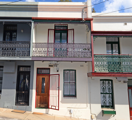
Figure 1: Site Frontage.
3. Relevant history
A review of Council records indicates that there are no prior works or applications relevant to the subject proposal.
4. Proposal
The proposal seeks development consent for alterations and additions to the rear sections of the existing dwelling including, on the ground floor a new bathroom and kitchenette area, whilst the upper level includes a new bathroom, and bedroom.
5. Notification
The owners of adjoining and likely affected neighbouring properties were notified of the proposed development in accordance with the Randwick Comprehensive DCP 2013. The following submissions were received as a result of the notification process:
· 139 Clovelly Road Randwick
· 3/91 Drumalbyn Road
|
Issue |
Comment |
|
Existing Heritage Value The submissions raise concerns with regards to maintaining the heritage value of the subject site. |
A review of the plans and the heritage report, together with Councils heritage comments indicate that the heritage value of the item is suitably maintained.
The proposal is acceptable in this regard.
|
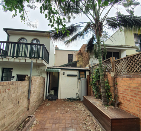
Figure 2: Existing Rear Elevation
Figure 3: Proposed Floorplans
6. Relevant Environment Planning Instruments
6.1. SEPP (Building Sustainability Index: BASIX) 2004
A BASIX certificate has been submitted in accordance with the requirements of the SEPP (Building Sustainability Index: BASIX) 2004.
6.2. Randwick Local Environmental Plan 2012 (LEP)
The site is zoned Residential R2 Low Density under Randwick Local Environmental Plan 2012 and the proposal is permissible with consent.
The proposal is consistent with the specific objectives of the zone in that the proposed activity and built form will provide for the housing needs of the community whilst enhancing the aesthetic character and protecting the amenity of the local residents.
The following development standards in the RLEP 2012 apply to the proposal:
|
Clause |
Development Standard |
Proposal |
Compliance (Yes/No) |
|
Cl 4.4: Floor space ratio (max) |
0.9:1 (73.98m2) |
0.77:1 (63.37m2) |
YES |
|
Cl 4.3: Building height (max) |
12m |
7.21m Existing
6.11m New Work |
YES
YES |
6.2.1. Clause 5.10 - Heritage conservation
The subject property is one of 13 attached two storey Victorian terraces within a row of a group of heritage listed terrace at 2-26 Gordon Street known as ‘Gordon Terrace’ (I386) listed within Schedule 5 of the Randwick LEP.
A review of the plans and documentation indicates that the proposal will maintain the heritage significance of the site and show regard for the objectives of the heritage controls contained within the Plan. In addition, the proposal is supported for the following reasons:
· External works do not add any significant bulk or detract from the heritage significance of the building or the streetscape
· The elements of the building to be demolished has significant structural damage.
· The building to be demolished is a non-contributory building in the conservation area and will be replaced by an appropriately designed infill building
7. Development control plans and policies
7.1. Randwick Comprehensive DCP 2013
The DCP provisions are structured into two components: objectives and controls. The objectives provide the framework for assessment under each requirement and outline key outcomes that a development is expected to achieve. The controls contain both numerical standards and qualitative provisions. Any proposed variations from the controls may be considered only where the applicant successfully demonstrates that an alternative solution could result in a more desirable planning and urban design outcome.
The relevant provisions of the DCP are addressed in Appendix 2.
8. Environmental Assessment
The site has been inspected and the application has been assessed having regard to Section 4.15 of the Environmental Planning and Assessment Act, 1979, as amended.
|
Section 4.15 ‘Matters for Consideration’ |
Comments |
|
Section 4.15 (1)(a)(i) – Provisions of any environmental planning instrument |
See discussion in sections 6 & 7.
|
|
Section 4.15(1)(a)(ii) – Provisions of any draft environmental planning instrument |
Nil. |
|
Section 4.15(1)(a)(iii) – Provisions of any development control plan |
The proposal generally satisfies the objectives and controls of the Randwick Comprehensive DCP 2013. See table in Appendix 2.
|
|
Section 4.15(1)(a)(iiia) – Provisions of any Planning Agreement or draft Planning Agreement |
Not applicable. |
|
Section 4.15(1)(a)(iv) – Provisions of the regulations |
The relevant clauses of the Regulations have been satisfied. |
|
Section 4.15(1)(b) – The likely impacts of the development, including environmental impacts on the natural and built environment and social and economic impacts in the locality |
The environmental impacts of the proposed development on the natural and built environment have been addressed in this report.
The proposed development is consistent with the dominant residential character in the locality.
The proposal will not result in detrimental social or economic impacts on the locality. |
|
Section 4.15(1)(c) – The suitability of the site for the development |
The site is located in close proximity to local services and public transport. The site has sufficient area to accommodate the proposed land use and associated structures. Therefore, the site is considered suitable for the proposed development. |
|
Section 4.15(1)(d) – Any submissions made in accordance with the EP&A Act or EP&A Regulation
|
The issues raised in the submissions have been addressed in this report. |
|
Section 4.15(1)(e) – The public interest |
The proposal promotes the objectives of the zone and will not result in any significant adverse environmental, social or economic impacts on the locality. Accordingly, the proposal is considered to be in the public interest. |
9. Conclusion
That the application for alterations and additions to the existing dwelling be approved (subject to conditions) for the following reasons:
· The proposal is consistent with the objectives contained within the RLEP 2012 and the relevant requirements of the RDCP 2013
· The proposal is consistent with the specific objectives of the R2 zone in that the proposed activity and built form will provide for the housing needs of the community whilst enhancing the aesthetic character and protecting the amenity of the local residents.
· The scale and design of the proposal is considered to be suitable for the location and is compatible with the desired future character of the locality.
Appendix 1: Referrals
1. Internal referral comments:
1.1. Heritage planner
The Site
The site is located on the southern side of Gordon Street and is one of 13 attached two storey Victorian terraces within a row of a group of heritage listed terrace at 2-26 Gordon Street known as ‘Gordon Terrace’ (I386) listed within Schedule 5 of the Randwick LEP. The following description of Gordon Terrace is provided within the NSW State Heritage Register:
Excellent row of mid-Victorian style terraces. Dated 1885. Not as ostentatious as most terraces from this period suggesting workers' accommodation, eg- no mouldings. Feature cantilevered balconies over footpath. Of major streetscape importance for consistency and stepping effect created by balconies following the slope of the street. Most have some alterations, but nothing major. All appear to retain original cast iron lace decoration on balcony balustrades, brackets and fringes. Openings unaltered although doors and windows replaced or altered on a number of houses. Main inconsistences are colour schemes and security grilles.
It also provides the following Statement of Significance for the item:
The terrace is one of the few surviving examples of row housing in the municipality. A good example of modest terraces houses in what was an ostentatious period. Reminiscent of British working class dwellings. It contributes to the village quality of the Gordon Street and Waverley Street neighbourhood. The consistency, scale and stepping effect create an outstanding streetscape.
The listed row is also located within the Gordon Square Heritage Conservation Area (CA10) recognised for its aesthetic significance comprising an interesting mix of small and large terraces, semi-detached and single storey rows and free standing cottages, and mixture of Victorian and Federation styles within an intimate street layout. It comprises historical and social significance as examples of nineteenth century worker housing in connection with Randwick Racecourse. They are also has a high degree of integrity to its turn of the century streetscapes.
No.22 is the third terrace from the eastern end of the row. A narrow pedestrian (dunny lane) runs along the southern boundary on the terraces with access via Waverly Street. The lane is currently used to store the domestic waste bins for the terraces. Internal photographs provided within the heritage impact statement submitted with the application indicate that there is some original internal fabric remaining within the front living and bedrooms, however later alterations are evident at the rear with contemporary kitchen area and late twentieth century bathroom at rear ground level.
It is recognised that a number of dwellings within the row have undergone substantial rear alterations and additions transforming their single storey rear wing into two storey rear wings, and in some instances to the full width of the site. Of particular note is the rear addition approved in 2013 at No.14 Gordon Street (to the west).
Background
Council’s records indicate that DA and BA approval was granted on 1994 for alterations and addition to the rear of the existing terrace. The approval included alterations to the living areas at rear ground floor, and the rear addition of a new bedroom at first floor level. It appears however that while works were undertaken at ground level, the first-floor additions for an additional room at the rear was not carried out.
Proposal
The proposal seeks to remove the internal walls and fixtures from the rear ground floor areas and remove the existing combination skillion roof at rear level as well as the rear chimney on the eastern boundary. It also proposes the removal of involves the rear first floor wall and window to allow for the construction of a two storey pavilion style rear addition and accommodate new open plan kitchen, living room at ground level with a small bathroom on the western side; and a new bedroom and bathroom at first floor level with an enclosed glazed balcony extending off the new bedroom on the southern elevation.
Submission
· Drawings prepared by Fang Architects, dated October 2020 and received by Council 2 February 2021;
· Heritage Impact Statement prepared by Damian O’Toole Town Planning, dated January 2021 and received by Council 2 February 2021;
· Statement of Environmental Effects prepared by Fang Architects dated January 2021 and received by Council 2 February 2021.
Controls
Clause 5.10(1) of Randwick Local Environmental Plan 2012 includes and Objective of conserving the heritage significance of heritage items and heritage conservation areas, including associated fabric, setting and views. Clause 5.10(4) of Randwick Local Environmental Plan 2012 requires Council to consider the effect of the proposed development on the heritage significance of the heritage item or heritage conservation area.
The Heritage section of Randwick Development Control Plan 2013 provided Objectives and Controls in relation to heritage properties.
Comments
As mentioned earlier, a number of dwellings within the row have undergone substantial alterations and additions at the rear to accommodate two storey rear wing extensions. It is noted that the subject dwelling has undergone minimal change towards the rear although the ground floor has been extended to accommodate a bathroom and internal works for contemporary living spaces with skylights to increase opportunities for natural light.
Ground floor
The application proposes to retain the existing ground floor setback to ensure it remains in line with the rear ground floor building line of the adjoining properties to the east and west (Nos.24 and 20 respectively). The existing ground floor rear wing will be largely rebuilt in terms external openings and internal walls. There are no heritage objections to the proposed changes, given that the rear wing comprises secondary fabric and has been substantially altered. There is also little consistency in the treatment of rear wings within the extended group and the proposed contemporary design of the rear ground floor elevation would sit cohesively within its immediate context.
The proposal does however involve the removal of the rear ground floor chimney, and while this detail is outlined on the demolition plan, it is not labelled on the drawing and not addressed within the HIS. Notwithstanding this, it is noted that the chimney does not relate to an existing fireplace (having been previously removed most likely as part of the 1994 renovations) and it is located at the rear, not significantly visible from the public domain and provides limited contribution to the aesthetic significance of the group as a whole. As such, its removal would have a minor impact on the item’s heritage significance. Notwithstanding this though, it is noted that there is still some loss of original external fabric, namely the intact rear window at upper level, as well as the rear chimney and its pot and it is recommended that these materials are salvaged for their reuse.
First floor
The proposal involves the rear extension of the first-floor level with a contemporary box style addition, connecting below roof level at the rear gutter line of the principle building to create a pavilion style rear wing addition. The proposal would extend to match the rear building line at ground floor, retaining a narrow lightwell over the ground floor bathroom and on the western side which would generally correspond with the position of the lightwell of the adjacent dwelling (no.20) to the west.
The proposal also involves the addition of an enclosed balcony extension with full length vertical glazing panels on the southern elevation. The style and design of the balcony and the rear extension as a whole is contemporary and clearly recognisable as new. The materials and finishes include a new metal skillion roof, Duragroove woodgrain cladding for the new wall, and aluminium framed windows to the balcony at first floor. The materials and finishes would be contemporary yet compatible with the original building materials. There appear to be no details of the proposed colours noted on the drawings and as an such, a condition is recommended to ensure they are considered by Council prior to issue of a CC.
Views/Vistas
The proposal would retain the front portion of the dwelling, allowing for its continued contribution to the significant terrace row and to the presentation along Gordon Street. Obscure views to the rear of the dwelling are available from the western side of Frank Doyle Park and from the rear access lane to the properties. Given the extent of the existing alterations along the rear of the row, the noted limited visibility of the rear wings from the public domain, and that the terraces principle presentation to the streetscape would be retained, it is considered that the proposal would have a minimal impact on the setting of the heritage item, streetscape or the winder conservation area.
Appendix 2: DCP Compliance Table
2.1 Part B2 – Heritage
The proposed development has been reviewed by Council’s Heritage Officer as contained in Appendix 1 above and the relevant provisions of Part B2 of the RDCP have been appropriately considered.
2.2 Part C1: Low Density Residential
|
DCP Clause |
Controls |
Proposal |
Compliance |
|
|
Classification |
Zoning = R2 low Density |
Permissible with consent |
|
2 |
Site planning |
|
|
|
2.1 |
Minimum lot size and frontage |
||
|
|
Minimum lot size (RLEP): · R2 = 400sqm |
82.2m |
As Existing |
|
|
Minimum frontage |
|
|
|
|
i) Min frontage R2 = 12m |
3.2m |
As Existing |
|
2.3 |
Site coverage |
||
|
|
Up to 300 sqm = 60%
|
57.1% (46.94m2) |
YES |
|
2.4 |
Landscaping and permeable surfaces |
||
|
|
i) Up to 300 sqm = 20% |
42% |
YES |
|
3 |
Building envelope |
||
|
3.1 |
Floor space ratio LEP 2012 = 0.9:1 |
0.77:1 |
YES |
|
3.2 |
Building height |
|
|
|
|
Maximum overall height LEP 2012 = 12m |
Existing = 7.2m
Proposed= 6.1m |
YES
YES |
|
|
i) Maximum external wall height = 8m |
6.1m |
YES |
|
3.3 |
Setbacks |
||
|
3.3.1 |
Front setbacks i) Average setbacks of adjoining |
No Change |
YES – As Existing |
|
3.3.2 |
Side setbacks: · Frontage less than 9m = 900mm
|
No Change |
YES – As Existing |
|
3.3.3 |
Rear setbacks i) Minimum 25% of allotment depth or 8m, whichever lesser. Note: control does not apply to corner allotments.
|
9.1m |
YES |
|
4 |
Building design |
||
|
4.1 |
General |
||
|
|
Respond specifically to the site characteristics and the surrounding natural and built context -
· articulated to enhance streetscape
· no side elevation greater than 12m
· encourage innovative design |
Complies
Complies
Complies |
YES
YES
YES |
|
4.5 |
Colours, Materials and Finishes |
||
|
|
Schedule of materials and finishes
Finishing is durable and non-reflective.
Minimise expanses of rendered masonry at street frontages (except due to heritage consideration)
Articulate and create visual interest by using combination of materials and finishes.
Suitable for the local climate to withstand natural weathering, ageing and deterioration. |
Complies
Complies
Complies
Complies |
YES
YES
YES
YES |
|
5.1 |
Solar access and overshadowing |
||
|
|
Solar access to proposed development: |
|
|
|
|
Portion of north-facing living room windows must receive a minimum of 3 hrs direct sunlight between 8am and 4pm on 21 June
POS (passive recreational activities) receive a minimum of 3 hrs of direct sunlight between 8am and 4pm on 21 June. |
No Change
No Change |
YES
YES |
|
|
Solar access to neighbouring development: |
|
|
|
|
Portion of the north-facing living room windows must receive a minimum of 3 hours of direct sunlight between 8am and 4pm on 21 June.
POS (passive recreational activities) receive a minimum of 3 hrs of direct sunlight between 8am and 4pm on 21 June.
|
No Change
No Change |
YES
YES |
|
5.2 |
Energy Efficiency and Natural Ventilation |
||
|
|
Provide day light to internalised areas within the dwelling (for example, hallway, stairwell, walk-in-wardrobe and the like) and any poorly lit habitable rooms via measures such as:
· Skylights (ventilated)
· Clerestory windows
· Fanlights above doorways
· Highlight windows in internal partition walls
Where possible, provide natural lighting and ventilation to any internalised toilets, bathrooms and laundries
living rooms contain windows and doors opening to outdoor areas
|
Complies
Complies
Complies
Complies
Complies
Complies |
YES
YES
YES
YES
YES
YES |
|
5.3 |
Visual Privacy |
||
|
|
Windows |
|
|
|
|
proposed habitable room windows must be located to minimise any direct viewing of existing habitable room windows in adjacent dwellings by one or more of the following measures:
- minimum 1600mm window sills
- Install fixed and translucent glazing up to 1600mm minimum.
- Install fixed privacy screens to windows.
- Creating a recessed courtyard (minimum 3m x 2m).
orientate living and dining windows away from adjacent dwellings (that is orient to front or rear or side courtyard) |
Complies
Complies
Complies
Complies
Complies |
YES
YES
YES
YES
YES |
|
|
Balcony |
|
|
|
|
Upper floor balconies to street or rear yard of the site (wrap around balcony to have a narrow width at side)
minimise overlooking of POS via privacy screens (fixed, minimum of 1600mm high and achieve minimum of 70% opaqueness (glass, timber or metal slats and louvers)
Supplementary privacy devices: Screen planting and planter boxes (Not sole privacy protection measure)
For sloping sites, step down any ground floor terraces and avoid large areas of elevated outdoor recreation space. |
Complies
Complies
Complies
Complies |
YES
YES
YES
YES |
|
5.4 |
Acoustic Privacy |
||
|
|
noise sources not located adjacent to adjoining dwellings bedroom windows |
Complies |
YES |
|
5.5 |
Safety and Security |
||
|
|
dwellings main entry on front elevation (unless narrow site)
Street numbering at front near entry.
1 habitable room window (glazed area min 2 square metres) overlooking the street or a public place.
Front fences, parking facilities and landscaping does not to obstruct casual surveillance (maintain safe access) |
Complies
Complies
Complies
Complies |
YES
YES
YES
YES |
|
1.⇩ |
RLPP Dev Consent Conditions (dwellings dual occ) - DA/42/2021 - 22 Gordon Street, RANDWICK |
|
Responsible officer: Mitchell Drake, Senior Environmental Planning Officer
File Reference: DA/42/2021
|
RLPP Dev Consent Conditions (dwellings dual occ) - DA/42/2021 - 22 Gordon Street, RANDWICK |
Attachment 1 |
|
Folder /DA No: |
DA/42/2021 |
|
Property: |
22 Gordon Street, RANDWICK NSW 2031 |
|
Proposal: |
Alterations and additions to existing attached dwelling, including partial demolition and ground / first floor extension to the rear with first floor balcony and associated works (Heritage Item and Heritage Conservation Area). |
|
Recommendation: |
Approval |
Development Consent Conditions
GENERAL CONDITIONS
The development must be carried out in accordance with the following conditions of consent.
These conditions have been applied to satisfy the relevant requirements of the Environmental Planning & Assessment Act 1979, Environmental Planning & Assessment Regulation 2000 and to provide reasonable levels of environmental amenity.
Approved Plans & Supporting Documentation
1. The development must be implemented substantially in accordance with the plans and supporting documentation listed below and endorsed with Council’s approved stamp, except where amended by Council in red and/or by other conditions of this consent:
|
Plan |
Drawn by |
Dated |
|
DA.01 Rev. C |
Fang Architects |
19 March 2021 |
|
DA.02 Rev. C |
Fang Architects |
19 March 2021 |
|
DA.03 Rev. C |
Fang Architects |
19 March 2021 |
|
DA.04 Rev. C |
Fang Architects |
19 March 2021 |
|
DA.05 Rev. C |
Fang Architects |
19 March 2021 |
|
DA.06 Rev. C |
Fang Architects |
19 March 2021 |
|
BASIX Certificate No. |
Dated |
|
A404348_03 |
25 January 2021 |
REQUIREMENTS BEFORE A CONSTRUCTION CERTIFICATE CAN BE ISSUED
The following conditions of consent must be complied with before a ‘Construction Certificate’ is issued by either Randwick City Council or an Accredited Certifier. All necessary information to demonstrate compliance with the following conditions of consent must be included in the documentation for the construction certificate.
These conditions have been applied to satisfy the relevant requirements of the Environmental Planning & Assessment Act 1979, Environmental Planning & Assessment Regulation 2000, Council’s development consent conditions and to achieve reasonable levels of environmental amenity.
Consent Requirements
2. The requirements and amendments detailed in the ‘General Conditions’ must be complied with and be included in the construction certificate plans and associated documentation.
External Colours, Materials & Finishes
3. The colours, materials and finishes of the external surfaces to the building are to be compatible with the existing building and surrounding buildings in the heritage conservation area. Details of the proposed colours, materials and textures (ie- a schedule and brochure/s or sample board) are to be submitted to and approved by Council’s Manager Development Assessment, prior to a construction certificate being issued for the development.
Section 7.12 Development Contributions
4. In accordance with Council’s Development Contributions Plan effective from 21 April 2015, based on the development cost of $117,403 the following applicable monetary levy must be paid to Council: $587.
The levy must be paid in cash, bank cheque or by credit card prior to a construction certificate being issued for the proposed development. The development is subject to an index to reflect quarterly variations in the Consumer Price Index (CPI) from the date of Council’s determination to the date of payment. Please contact Council on telephone 9093 6999 or 1300 722 542 for the indexed contribution amount prior to payment.
To calculate the indexed levy, the following formula must be used:
IDC = ODC x CP2/CP1
Where:
IDC = the indexed development cost
ODC = the original development cost determined by the Council
CP2 = the Consumer Price Index, All Groups, Sydney, as published by the ABS in respect of the quarter ending immediately prior to the date of payment
CP1 = the Consumer Price Index, All Groups, Sydney as published by the ABS in respect of the quarter ending immediately prior to the date of imposition of the condition requiring payment of the levy.
Council’s Development Contribution Plans may be inspected at the Customer Service Centre, Administrative Centre, 30 Frances Street, Randwick or at www.randwick.nsw.gov.au.
Compliance Fee
5. A development compliance and enforcement fee of $117.40 shall be paid to Council in accordance with Council’s adopted Fees & Charges Pricing Policy, prior to the issue of a Construction Certificate for development.
Long Service Levy Payments
6. The required Long Service Levy payment, under the Building and Construction Industry Long Service Payments Act 1986, must be forwarded to the Long Service Levy Corporation or the Council, in accordance with Section 6.8 of the Environmental Planning & Assessment Act 1979.
At the time of this development consent, Long Service Levy payment is applicable on building work having a value of $25,000 or more, at the rate of 0.35% of the cost of the works.
Security Deposits
7. The following security deposits requirement must be complied with prior to a construction certificate being issued for the development, as security for making good any damage caused to Council’s assets and infrastructure; and as security for completing any public work; and for remedying any defect on such public works, in accordance with section 4.17(6) of the Environmental Planning and Assessment Act 1979:
· $600 - Damage / Civil Works Security Deposit
The security deposits may be provided by way of a cash, cheque or credit card payment and is refundable upon a satisfactory inspection by Council upon the completion of the works which confirms that there has been no damage to Council's assets and infrastructure.
The developer/builder is also requested to advise Council in writing and/or photographs of any signs of existing damage to the Council roadway, footway, or verge and other assets prior to the commencement of any building/demolition works.
To obtain a refund of relevant deposits, a Security Deposit Refund Form is to be forwarded to Council’s Development Engineer upon issuing of an occupation certificate or completion of the civil works.
Sydney Water Requirements
8. All building, plumbing and drainage work must be carried out in accordance with the requirements of the Sydney Water Corporation.
The approved plans must be submitted to the Sydney Water Tap in™ online service, to determine whether the development will affect Sydney Water’s waste water and water mains, stormwater drains and/or easements, and if any further requirements need to be met.
The Sydney Water Tap in™ online service replaces the Quick Check Agents as of 30 November 2015
The Tap in™ service provides 24/7 access to a range of services, including:
· Building plan approvals
· Connection and disconnection approvals
· Diagrams
· Trade waste approvals
· Pressure information
· Water meter installations
· Pressure boosting and pump approvals
· Change to an existing service or asset, e.g. relocating or moving an asset.
Sydney Water’s Tap in™ in online service is available at:
The Principal Certifier must ensure that the developer/owner has submitted the approved plans to Sydney Water Tap in online service.
Salvage Plan
9. A salvage plan shall be prepared and submitted to and approved by Council’s Director City Planning, in accordance with Section 4.17 of the Environmental Planning and Assessment Act 1979 prior to a construction certificate being issued for the development. The salvage plan is required to ensure that materials including original windows and chimney being remnant components of significant heritage fabric are carefully removed and stored, sold or donated to a heritage salvaging yard to facilitate the conservation of other buildings of a similar period.
REQUIREMENTS TO BE INCLUDED IN THE CONSTRUCTION CERTIFICATE
The requirements contained in the following conditions of consent must be complied with and details of compliance must be included in the construction certificate for the development.
These conditions have been applied to satisfy the relevant requirements of the Environmental Planning & Assessment Act 1979, Environmental Planning & Assessment Regulation 2000, Councils development consent conditions and to achieve reasonable levels of environmental amenity.
Compliance with the Building Code of Australia & Relevant Standards
10. In accordance with section 4.17 (11) of the Environmental Planning & Assessment Act 1979 and clause 98 of the Environmental Planning & Assessment Regulation 2000, it is a prescribed condition that all building work must be carried out in accordance with the provisions of the Building Code of Australia (BCA).
BASIX Requirements
11. In accordance with section 4.17 (11) of the Environmental Planning & Assessment Act 1979 and clause 97A of the Environmental Planning & Assessment Regulation 2000, the requirements and commitments contained in the relevant BASIX Certificate must be complied with.
The required commitments listed and identified in the BASIX Certificate must be included on the construction certificate plans, specifications and associated documentation, to the satisfaction of the Certifying Authority.
The design of the building must not be inconsistent with the development consent and any proposed variations to the building to achieve the BASIX commitments may necessitate a new development consent or amendment to the existing consent to be obtained, prior to a construction certificate being issued.
Stormwater Drainage
12. A surface water/stormwater drainage system must be provided in accordance with the following requirements, to the satisfaction of the Certifierand details are to be included in the construction certificate:-
a) Surface water/stormwater drainage systems must be provided in accordance with the relevant provisions of the Building Code of Australia (Volume 2) and relevant Standards;
b) The surface water/stormwater must be drained and discharged to the street gutter or, subject to site suitability, the stormwater may be drained to a suitably designed absorption pit;
c) Any absorption pits or soaker wells should be located not less than 3m from any adjoining premises and the stormwater must not be directed to any adjoining premises or cause a nuisance;
d) External paths and ground surfaces are to be constructed at appropriate levels and be graded and drained away from the building and adjoining premises, so as not to result in the entry of water into the building, or cause a nuisance or damage to the adjoining premises;
e) Details of any proposed drainage systems or works to be carried out in the road, footpath or nature strip must be submitted to and approved by Council before commencing these works:
f) A certificate, from a suitably qualified person must be submitted to the Principal Certifier and Council, prior to the issue of an Occupation Certificate, which confirms that the stormwater drainage system has been provided in accordance with the requirements of this consent, relevant standards and requirements.
REQUIREMENTS PRIOR TO THE COMMENCEMENT OF ANY WORKS
The following conditions of consent must be complied with prior to the commencement of any works on the site. The necessary documentation and information must be provided to the Council or the ‘Principal Certifier’, as applicable.
These conditions have been applied to satisfy the relevant requirements of the Environmental Planning & Assessment Act 1979, Environmental Planning & Assessment Regulation 2000 and to provide reasonable levels of public health, safety and environmental amenity.
Certification and Building Inspection Requirements
13. Prior to the commencement of any building works, the following requirements must be complied with:
a) a Construction Certificate must be obtained from the Council or an accredited certifier, in accordance with the provisions of the Environmental Planning & Assessment Act 1979.
A copy of the construction certificate, the approved development consent plans and consent conditions must be kept on the site at all times and be made available to the Council officers and all building contractors for assessment.
b) a Principal Certifier must be appointed to carry out the necessary building inspections and to issue an occupation certificate; and
c) a principal contractor must be appointed for the building work, or in relation to residential building work, an owner-builder permit may be obtained in accordance with the requirements of the Home Building Act 1989, and the Principal Certifier and Council are to be notified accordingly; and
d) the principal contractor must be advised of the required critical stage inspections and other inspections to be carried out, as specified by the Principal Certifier; and
e) at least two days notice must be given to the Council, in writing, prior to commencing any works.
Home Building Act 1989
14. In accordance with section 4.17 (11) of the Environmental Planning & Assessment Act 1979 and clause 98 of the Environmental Planning & Assessment Regulation 2000, the relevant requirements of the Home Building Act 1989 must be complied with.
Details of the Licensed Building Contractor and a copy of the relevant Certificate of Home Warranty Insurance or a copy of the Owner-Builder Permit (as applicable) must be provided to the Principal Certifier and Council.
Dilapidation Reports
15. A dilapidation report must be obtained from a Professional Engineer, Building Surveyor or other suitably qualified independent person, in the following cases:
· excavations for new dwellings, additions to dwellings, swimming pools or other substantial structures which are proposed to be located within the zone of influence of the footings of any dwelling, associated garage or other substantial structure located upon an adjoining premises;
· new dwellings or additions to dwellings sited up to shared property boundaries (e.g. additions to a semi-detached dwelling or terraced dwellings);
· excavations for new dwellings, additions to dwellings, swimming pools or other substantial structures which are within rock and may result in vibration and or potential damage to any dwelling, associated garage or other substantial structure located upon an adjoining premises;
· as otherwise may be required by the Principal Certifier.
The dilapidation report shall include details of the current condition and status of any dwelling, associated garage or other substantial structure located upon the adjoining premises and shall include relevant photographs of the structures, to the satisfaction of the Principal Certifier.
The dilapidation report must be submitted to the Council, the Principal Certifier and the owners of the adjoining/nearby premises encompassed in the report, prior to commencing any site works (including any demolition work, excavation work or building work).
Construction Noise & Vibration Management Plan
16. Noise and vibration emissions during the construction of the building and associated site works must not result in damage to nearby premises or result in an unreasonable loss of amenity to nearby residents and the relevant requirements of the Protection of the Environment Operations Act 1997 and NSW EPA Guidelines must be satisfied at all times.
Noise and vibration from any rock excavation machinery, pile drivers and all plant and equipment must be minimised, by using appropriate plant and equipment, silencers and the implementation of noise management strategies.
A Construction Noise Management Plan, prepared in accordance with the NSW EPA Construction Noise Guideline by a suitably qualified person, is to be implemented throughout the works, to the satisfaction of the Council. A copy of the strategy must be provided to the Principal Certifier and Council prior to the commencement of works on site.
Construction Site Management Plan
17. A Construction Site Management Plan must be developed and implemented prior to the commencement of any works. The construction site management plan must include the following measures, as applicable to the type of development:
· location and construction of protective site fencing / hoardings;
· location of site storage areas/sheds/equipment;
· location of building materials for construction;
· provisions for public safety;
· dust control measures;
· details of proposed sediment and erosion control measures;
· site access location and construction
· details of methods of disposal of demolition materials;
· protective measures for tree preservation;
· location and size of waste containers/bulk bins;
· provisions for temporary stormwater drainage;
· construction noise and vibration management;
· construction traffic management details;
· provisions for temporary sanitary facilities.
The site management measures must be implemented prior to the commencement of any site works and be maintained throughout the works, to the satisfaction of Council.
A copy of the Construction Site Management Plan must be provided to the Principal Certifier and Council prior to commencing site works. A copy must also be maintained on site and be made available to Council officers upon request.
Demolition Work
18. Demolition Work must be carried out in accordance with Australian Standard AS2601-2001, Demolition of Structures and relevant work health and safety requirements.
A Demolition Work Plan must be prepared for the demolition works which should be submitted to the Principal Certifier, not less than two (2) working days before commencing any demolition work. A copy of the Demolition Work Plan must be maintained on site and be made available to Council officers upon request.
If the work involves asbestos products or materials, a copy of the Demolition Work Plan must also be provided to Council not less than 2 days before commencing those works.
Demolition & Construction Waste Plan
19. A Demolition and Construction Waste Management Plan (WMP) must be development and implemented for the development.
The Waste Management Plan must provide details of the type and quantities of demolition and construction waste materials, proposed re-use and recycling of materials, methods of disposal and details of recycling outlets and land fill sites.
Where practicable waste materials must be re-used or recycled, rather than disposed and further details of Council's requirements including relevant guidelines and pro-forma WMP forms can be obtained from Council's Customer Service Centre or by telephoning Council on 1300 722 542.
Details and receipts verifying the recycling and disposal of materials must be kept on site at all times and presented to Council officers upon request.
Public Utilities
20. A Public Utility Impact Assessment must be carried out to identify all public utility services located on the site, roadway, nature strip, footpath, public reserve or any public areas associated with and/or adjacent to the building works.
Documentary evidence from the relevant public utility authorities confirming that their requirements have been or are able to be satisfied, must be submitted to the Principal Certifier prior to the commencement of any works.
The owner/builder must make the necessary arrangements and meet the full cost for telecommunication companies, gas providers, Energy Australia, Sydney Water and other authorities to adjust, repair or relocate their services as required.
REQUIREMENTS DURING CONSTRUCTION & SITE WORK
The following conditions of consent must be complied with during the demolition, excavation and construction of the development.
These conditions have been applied to satisfy the relevant requirements of the Environmental Planning & Assessment Act 1979, Environmental Planning & Assessment Regulation 2000 and to provide reasonable levels of public health, safety and environmental amenity during construction.
Inspections during Construction
21. Building works are required to be inspected by the Principal Certifier, in accordance with section 6.5 of the Environmental Planning & Assessment Act 1979 and clause 162A of the Environmental Planning & Assessment Regulation 2000, to monitor compliance with the relevant standards of construction, Council’s development consent and the construction certificate.
Site Signage
22. A sign must be erected and maintained in a prominent position on the site for the duration of the works, which contains the following details:
· name, address, contractor licence number and telephone number of the principal contractor, including a telephone number at which the person may be contacted outside working hours, or owner-builder permit details (as applicable)
· name, address and telephone number of the Principal Certifier,
· a statement stating that “unauthorised entry to the work site is prohibited”.
Restriction on Working Hours
23. Building, demolition and associated site works must be carried out in accordance with the following requirements:
|
Activity |
Permitted working hours |
|
All building, demolition and site work, including site deliveries (except as detailed below) |
· Monday to Friday - 7.00am to 5.00pm · Saturday - 8.00am to 5.00pm · Sunday & public holidays - No work permitted |
|
Excavating or sawing of rock, use of jack-hammers, pile-drivers, vibratory rollers/compactors or the like
|
· Monday to Friday - 8.00am to 5.00pm · Saturday - No work permitted · Sunday & public holidays - No work permitted |
An application to vary the abovementioned hours may be submitted to Council’s Manager Health, Building & Regulatory Services for consideration and approval to vary the specified hours may be granted in exceptional circumstances and for limited occasions (e.g. for public safety, traffic management or road safety reasons). Any applications are to be made on the standard application form and include payment of the relevant fees and supporting information. Applications must be made at least 10 days prior to the date of the proposed work and the prior written approval of Council must be obtained to vary the standard permitted working hours.
Removal of Asbestos Materials
24. Any work involving the demolition, storage or disposal of asbestos products and materials must be carried out in accordance with the following requirements:
· Occupational Health & Safety legislation and WorkCover NSW requirements
· Randwick City Council’s Asbestos Policy
· A WorkCover licensed demolition or asbestos removal contractor must undertake removal of more than 10m2 of bonded asbestos (or as otherwise specified by WorkCover or relevant legislation). Removal of friable asbestos material must only be undertaken by contractor that holds a current friable asbestos removal licence. A copy of the relevant licence must be provided to the Principal Certifier.
· On sites involving the removal of asbestos, a sign must be clearly displayed in a prominent visible position at the front of the site, containing the words ‘DANGER ASBESTOS REMOVAL IN PROGRESS’ and include details of the licensed contractor.
· Asbestos waste must be stored, transported and disposed of in compliance with the Protection of the Environment Operations Act 1997 and the Protection of the Environment Operations (Waste) Regulation 2005. Details of the landfill site (which must be lawfully able to receive asbestos materials) must be provided to the Principal Certifier.
· A Clearance Certificate or Statement, prepared by a suitably qualified person (i.e. an occupational hygienist, licensed asbestos assessor or other competent person), must be provided to Council and the Principal Certifier upon completion of the asbestos related works which confirms that the asbestos material have been removed appropriately and the relevant conditions of consent have been satisfied.
A copy of Council’s Asbestos Policy is available on Council’s web site at www.randwick.nsw.gov.au in the Building & Development Section or a copy can be obtained from Council’s Customer Service Centre.
Excavations, Back-filling & Retaining Walls
25. All excavations and backfilling associated with the erection or demolition of a building must be executed safely in accordance with appropriate professional standards and excavations must be properly guarded and supported to prevent them from being dangerous to life, property or buildings.
Retaining walls, shoring or piling must be provided to support land which is excavated in association with the erection or demolition of a building, to prevent the movement of soil and to support the adjacent land and buildings, if the soil conditions require it. Adequate provisions are also to be made for drainage.
Details of proposed retaining walls, shoring, piling or other measures are to be submitted to and approved by the Principal Certifier.
Support of Adjoining Land
26. In accordance with section 4.17 (11) of the Environmental Planning & Assessment Act 1979 and clause 98 E of the Environmental Planning & Assessment Regulation 2000, it is a prescribed condition that the adjoining land and buildings located upon the adjoining land must be adequately supported at all times.
27. Prior to undertaking any demolition, excavation or building work in the following circumstances, a report must be obtained from a professional engineer which details the methods of support for the dwelling or associated structure on the adjoining land, to the satisfaction of the Principal Certifier:
· when undertaking excavation or building work within the zone of influence of the footings of a dwelling or associated structure that is located on the adjoining land;
· when undertaking demolition work to a wall of a dwelling that is built to a common or shared boundary (e.g. semi-detached or terrace dwelling);
· when constructing a wall to a dwelling or associated structure that is located within 900mm of a dwelling located on the adjoining land;
· as may be required by the Principal Certifier.
The demolition, excavation and building work and the provision of support to the dwelling or associated structure on the adjoining land, must also be carried out in accordance with the abovementioned report, to the satisfaction of the Principal Certifier.
Sediment & Erosion Control
28. Sediment and erosion control measures, must be implemented throughout the site works in accordance with the manual for Managing Urban Stormwater – Soils and Construction, published by Landcom.
Details of the sediment and erosion control measures to be implemented on the site must be included in with the Construction Management Plan and be provided to the Principal Certifier and Council. A copy must also be maintained on site and be made available to Council officers upon request.
Public Safety & Site Management
29. Public safety and convenience must be maintained at all times during demolition, excavation and construction works and the following requirements must be complied with:
a) Public access to the building site and materials must be restricted by existing boundary fencing or temporary site fencing having a minimum height of 1.5m, to Council’s satisfaction.
Temporary site fences are required to be constructed of cyclone wire fencing material and be structurally adequate, safe and constructed in a professional manner. The use of poor quality materials or steel reinforcement mesh as fencing is not permissible.
b) Building materials, sand, soil, waste materials, construction equipment or other articles must not be placed upon the footpath, roadway or nature strip at any time.
c) The road, footpath, vehicular crossing and nature strip must be maintained in a good, safe, clean condition and free from any excavations, obstructions, trip hazards, goods, materials, soils or debris at all times. Any damage caused to the road, footway, vehicular crossing, nature strip or any public place must be repaired immediately, to the satisfaction of Council.
d) All building and site activities (including storage or placement of materials or waste and concrete mixing/pouring/pumping activities) must not cause or be likely to cause ‘pollution’ of any waters, including any stormwater drainage systems, street gutters or roadways.
Note: It is an offence under the Protection of the Environment Operations Act 1997 to cause or be likely to cause ‘pollution of waters’, which may result in significant penalties and fines.
e) Access gates and doorways within site fencing, hoardings and temporary site buildings or amenities must not open out into the road or footway.
f) Site fencing, building materials, bulk bins/waste containers and other articles must not be located upon the footpath, roadway or nature strip at any time without the prior written approval of the Council. Applications to place a waste container in a public place can be made to Council’s Health, Building and Regulatory Services department.
g) Adequate provisions must be made to ensure pedestrian safety and traffic flow during the site works and traffic control measures are to be implemented in accordance with the relevant provisions of the Roads and Traffic Manual “Traffic Control at Work Sites” (Version 4), to the satisfaction of Council.
h) A Road / Asset Opening Permit must be obtained from Council prior to carrying out any works within or upon a road, footpath, nature strip or in any public place, in accordance with section 138 of the Roads Act 1993 and all of the conditions and requirements contained in the Road / Asset Opening Permit must be complied with. Please contact Council’s Road/Asset Openings officer on 9093 6691 for further details.
i) Temporary toilet facilities are to be provided, at or in the vicinity of the work site throughout the course of demolition and construction, to the satisfaction of WorkCover NSW and the toilet facilities must be connected to a public sewer or other sewage management facility approved by Council.
Site Signage
30. A sign must be erected and maintained in a prominent position on the site for the duration of the works, which contains the following details:
· name, address, contractor licence number and telephone number of the principal contractor, including a telephone number at which the person may be contacted outside working hours, or owner-builder permit details (as applicable)
· name, address and telephone number of the Principal Certifier,
· a statement stating that “unauthorised entry to the work site is prohibited”.
Survey Requirements
31. A Registered Surveyor’s check survey certificate or other suitable documentation must be obtained at the following stage/s of construction to demonstrate compliance with the approved setbacks, levels, layout and height of the building to the satisfaction of the Principal Certifier:
· prior to construction (pouring of concrete) of the footings or first completed floor slab,
· upon completion of the building, prior to issuing an occupation certificate,
· as otherwise may be required by the Principal Certifier.
The survey documentation must be forwarded to the Principal Certifier and a copy is to be forwarded to the Council, if the Council is not the Principal Certifier for the development.
Building Encroachments
32. There must be no encroachment of any structures or building work onto Council’s road reserve, footway, nature strip or public place.
REQUIREMENTS PRIOR TO THE ISSUE OF AN OCCUPATION CERTIFICATE
The following conditions of consent must be complied with prior to the ‘Principal Certifier’ issuing an ‘Occupation Certificate’.
These conditions have been applied to satisfy the relevant requirements of the Environmental Planning & Assessment Act 1979, Environmental Planning & Assessment Regulation 2000, Council’s development consent and to maintain reasonable levels of public health, safety and amenity.
Occupation Certificate Requirements
33. An Occupation Certificate must be obtained from the Principal Certifier prior to any occupation of the building work encompassed in this development consent (including alterations and additions to existing buildings), in accordance with the relevant provisions of the Environmental Planning & Assessment Act 1979.
BASIX Requirements & Certification
34. In accordance with Clause 154B of the Environmental Planning & Assessment Regulation 2000, a Certifiermust not issue an Occupation Certificate for this development, unless it is satisfied that any relevant BASIX commitments and requirements have been satisfied.
Relevant documentary evidence of compliance with the BASIX commitments is to be forwarded to the Principal Certifier and Council upon issuing an Occupation Certificate.
OPERATIONAL CONDITIONS
The following operational conditions must be complied with at all times, throughout the use and operation of the development.
These conditions have been applied to satisfy the relevant requirements of the Environmental Planning & Assessment Act 1979, Environmental Planning & Assessment Regulation 2000, Council’s development consent and to maintain reasonable levels of public health and environmental amenity.
External Lighting
35. External lighting to the premises must be designed and located so as to minimise light-spill beyond the property boundary or cause a public nuisance.
Plant & Equipment – Noise Levels
36. The operation of all plant and equipment on the premises shall not give rise to an ‘offensive noise’ as defined in the Protection of the Environment Operations Act 1997 and Regulations.
In this regard, the operation of the plant and equipment shall not give rise to an LAeq, 15 min sound pressure level at any affected premises that exceeds the background LA90, 15 min noise level, measured in the absence of the noise source/s under consideration by more than 5dB(A) in accordance with relevant NSW Environment Protection Authority (EPA) Noise Control Guidelines.
GENERAL ADVISORY NOTES
The following information is provided for your assistance to ensure compliance with the Environmental Planning & Assessment Act 1979, Environmental Planning & Assessment Regulation 2000, or other relevant legislation and requirements. This information does not form part of the conditions of development consent pursuant to Section 4.17 of the Act.
A1 The requirements and provisions of the Environmental Planning & Assessment Act 1979 and Environmental Planning & Assessment Regulation 2000, must be fully complied with at all times.
Failure to comply with these requirements is an offence, which renders the responsible person liable to a maximum penalty of $1.1 million. Alternatively, Council may issue a penalty infringement notice (for up to $3,000) for each offence. Council may also issue notices and orders to demolish unauthorised or non-complying building work, or to comply with the requirements of Council’s development consent.
A2 In accordance with the requirements of the Environmental Planning & Assessment Act 1979, building works, including associated demolition and excavation works (as applicable) must not be commenced until:
§ A Construction Certificate has been obtained from an Accredited Certifier or Council,
§ An Accredited Certifier or Council has been appointed as the Principal Certifier for the development,
§ Council and the Principal Certifier have been given at least 2 days notice (in writing) prior to commencing any works.
A3 Council can issue your Construction Certificate and be your Principal Certifier for the development, to undertake inspections and ensure compliance with the development consent and relevant building regulations. For further details contact Council on 9093 6944.
A4 This determination does not include an assessment of the proposed works under the Building Code of Australia (BCA) and other relevant Standards. All new building work (including alterations and additions) must comply with the BCA and relevant Standards and you are advised to liaise with your architect, engineer and building consultant prior to lodgement of your construction certificate.
A5 Any proposed amendments to the design and construction of the building may require a new development application or a section 4.55 amendment to the existing consent to be obtained from Council, before carrying out such works
A6 A Local Approval application must be submitted to and be approved by Council prior to commencing any of the following activities on a footpath, road, nature strip or in any public place:-
§ Install or erect any site fencing, hoardings or site structures
§ Operate a crane or hoist goods or materials over a footpath or road
§ Placement of a waste skip or any other container or article.
For further information please contact Council on 9093 6971.
A7 Specific details of the location of the building/s should be provided in the Construction Certificate to demonstrate that the proposed building work will not encroach onto the adjoining properties, Council’s road reserve or any public place.
A8 This consent does not authorise any trespass or encroachment upon any adjoining or supported land or building whether private or public. Where any underpinning, shoring, soil anchoring (temporary or permanent) or the like is proposed to be carried out upon any adjoining or supported land, the land owner or principal contractor must obtain:
§ the consent of the owners of such adjoining or supported land to trespass or encroach, or
§ an access order under the Access to Neighbouring Land Act 2000, or
§ an easement under section 88K of the Conveyancing Act 1919, or
§ an easement under section 40 of the Land & Environment Court Act 1979, as appropriate.
Section 177 of the Conveyancing Act 1919 creates a statutory duty of care in relation to support of land. Accordingly, a person has a duty of care not to do anything on or in relation to land being developed (the supporting land) that removes the support provided by the supporting land to any other adjoining land (the supported land).
A9 The finished ground levels external to the building must be consistent with the development consent and are not to be raised, other than for the provision of approved paving or the like on the ground
A10 Prior to commencing any works, the owner/builder should contact Dial Before You Dig on 1100 or www.dialbeforeyoudig.com.au and relevant Service Authorities, for information on potential underground pipes and cables within the vicinity of the development site.
A11 An application must be submitted to an approved by Council prior to the installation and operation of any proposed greywater or wastewater treatment systems, in accordance with the Local Government Act 1993.
Greywater/Wastewater treatment systems must comply with the relevant requirements and guidelines produced by NSW Health, NSW Office of Environment and Heritage and other relevant regulatory requirements.
A12 Council’s assessment of this application does not include an assessment of compliance with the Swimming Pool Act 1992. All pool barriers, fences and structures within properties containing a swimming pool must comply with the requirements of the Swimming Pool Act 1992, BCA and relevant Australian Standards.
Details of compliance with the Swimming Pool Act 1992, Building Code of Australia and relevant Standards must be included in the Construction Certificate to the satisfaction of the Certifying Authority.