![]()
![]()

Randwick Local Planning Panel (Public) Meeting
Tuesday 13 April 2021
 |
|||
 |
|||
![]()
![]()
Randwick Local Planning Panel (Public) Meeting
Tuesday 13 April 2021
|
|||
|
|||
Randwick Local Planning Panel (Public) meeting
 |
Randwick Local Planning Panel (Public)
Notice is hereby given that a Randwick Local Planning Panel (Public) meeting
will be held in the Online via Microsoft Teams on
Tuesday, 13 April 2021 at 1pm
Declarations of Pecuniary and Non-Pecuniary Interests
Address of RLPP by Councillors and members of the public
Privacy warning;
In respect to Privacy & Personal Information Protection Act, members of the public are advised that the proceedings of this meeting will be recorded.
General Reports
GR4/21 Randwick Comprehensive Planning Proposal - Rezoning Requests............................................ 1
GR5/21 Randwick Comprehensive Planning Proposal - Economic Development.................................... 37
GR6/21 Randwick Comprehensive Planning Proposal - Environmental Resilience............................... 157
Kerry Kyriacou
Director City Planning
Randwick Local Planning Panel (Public) meeting
|
General Report No. GR4/21
|
|
Subject: Randwick Comprehensive Planning Proposal - Rezoning Requests |
Executive Summary
· This report outlines a number of proposed amendments to the Randwick Local Environmental Plan 2012 in response rezoning requests submitted to Council between 2012 and 2021. Other reports that will inform the future Comprehensive Planning Proposal including Housing, Economic Development and Resilience also include rezoning requests that relate to those topics.
· The proposed amendments are a result of extensive site specific analysis, considering the strategic merit of each request against the strategic policy framework and the impact of the proposed zoning controls on the surrounding landscape and local area.
· The rezoning requests included in this report are either supported, not supported or recommended to be considered as part of future strategic analysis in accordance with the Randwick Local Strategy Planning Statement (LSPS) and Housing Strategy.
· The
supported rezoning requests will make a minor contribution to the housing
supply (less than 50 dwellings) and commercial floorspace in Randwick City,
with one site only (zoned B1 Neighbourhood Business at Little Bay) proposing an
increase in the maximum floor space ratio (from 1:1 to 1.2:1).
· The supported rezoning requests (changes to zoning and development standards i.e maximum building height and FSR) outlined in this report will be incorporated into a Comprehensive Planning Proposal seeking amendments to the RLEP 2012 to be reported to Council in May 2021.
|
That the Randwick Local Planning Panel advises Council that it supports the recommendations set out below to include the following sites in the draft Comprehensive Planning Proposal to be submitted for Gateway determination.
a) Rezoning Request Supported: 1903R Botany Road, Matraville
· Zone from RE1 Public Recreation to RE2 Private Recreation subject to an assessment provided under State Environmental Planning Policy No.55 – Remediation of Land · Maximum FSR: No change · Maximum Height: No change. b) Rezoning Request Supported: 558A – 580 Anzac Parade, Kingsford (Souths Juniors Site)
· Zone: No change · Maximum FSR: No change · Maximum Height: increase on part of the site from 31m to 51m (Alternative Building Height Map) · Design Excellence: clause 6.21 will apply to part of the site · Include the site in the Key Sites Map associated with clause 6.12 which will require the preparation of site specific DCP chapter to address design implications for the site of the recommended maximum building height changes.
c) Rezoning Request Supported: 1401-1409 Anzac Parade, Little Bay
· Zone: No change · Maximum FSR: increase the maximum FSR from 1:1 to 1.2:1 · Maximum Height: increase the maximum height from 9.5m to 15m · Include the site in the Key Sites Map associated with clause 6.11 which will require the preparation of site specific DCP chapter to address design implications for the site of the recommended maximum building height and maximum FSR changes.
d) Rezoning Request Supported: 59A-71 Boronia Street and 77-103 Anzac Parade, Kensington
· Maximum FSR: Not include a maximum FSR standard for 59A, 61, 63-65 Boronia Street and 81-85 Anzac Parade (Part) · Maximum Height: increase the maximum from 1m to 31m for the strip of land at the rear of 95, 91-93, 89, 87 and 81-85 Anzac Parade, Kensington. No other height change is supported. · Prepare a DCP Amendment to introduce envelope controls for the three (3) Boronia Street residential properties and battle axe portion of 81-85 Anzac Parade, in a future review of the K2K Block Controls – Part B. · No change to the Land Use Zoning: Retain R3 Medium Density Residential Zone for 59A, 61, 63-65 and 81-85 Anzac Parade (Part).
That the Randwick Local Planning Panel advises Council that it supports the recommendations set out below to not include the following rezoning requests in the Comprehensive Planning Proposal to be submitted for Gateway determination.
e) Rezoning Request Not Supported: 33-43 Boronia Street, Kensington
· Zoning: Retain R3 Medium Density Residential · Maximum FSR: No change · Maximum Height: No change.
f) Rezoning Request Not Supported: 204 Malabar Road, South Coogee
· Zoning: Retain R2 Low Density Residential · Maximum FSR: No change · Maximum Height: No change.
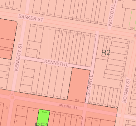
g) Rezoning Request Not Supported: 7 Kenneth Lane and 52-56 Middle Street, Kingsford
· Zoning: Retain R2 Low Density Residential · Maximum FSR: No change · Maximum Height: No change.
h) Rezoning Request Not Supported: 22-30 Victoria Street, Malabar (Souths Juniors, Malabar)
· Zoning: Retain R2 Low Density Residential · Maximum FSR: No change · Maximum Height: No change.
i) Rezoning Request Not Supported: 27 Jennifer Street, Little Bay
· Zoning: Retain R3 Medium Density Residential · Maximum FSR: No change · Maximum Height: No change · That Council write to Crown Lands in relation to the future acquisition of 27 Jennifer Street, Little Bay site within Crown Lands.
j) Rezoning Request Not Supported: 129-135 Malabar Road and 2 Napper Street, South Coogee
· Maximum FSR: No change · Maximum Height: No change.
That the Randwick Local Planning Panel advises Council that it supports the recommendation to carry out further strategic planning investigations of the following sites in accordance with the Randwick LSPS and Housing Strategy Actions.
k) Rezoning Request: 29-45 Willis Street & 40 Middle Street, Kingsford
Consider the rezoning request in a future review of transition and buffer areas around town and strategic centres in accordance with Action 3.2 of the Randwick Housing Strategy.
l) Rezoning Request: 100 Boyce Road, Maroubra
Consider the rezoning request in the future Eastgardens-Maroubra Junction Strategic Centre review under Action 9.4 of the Randwick LSPS.
m) Rezoning Request: 946 Anzac Parade, Maroubra Junction (Souths Juniors, Maroubra Junction)
Consider the rezoning request in the future Eastgardens-Maroubra Junction Strategic Centre review under Action 9.4 of the Randwick LSPS.
n) Rezoning Request: 217 Anzac Parade, Kensington
Consider the rezoning request in a future review of transition and buffer areas around town and strategic centres in accordance with Action 3.2 of the Randwick Housing Strategy.
o) Rezoning Request: 2 and 4 Harbourne Road, Kensington
Consider the rezoning request in a future review of transition and buffer areas around town and strategic centres in accordance with Action 3.2 of the Randwick Housing Strategy.
p) Rezoning Request: 6 Harbourne Road, Kensington
Consider the rezoning request in a future review of transition and buffer areas around town and strategic centres in accordance with Action 3.2 of the Randwick Housing Strategy.
q) Rezoning Request: 80-82 St Pauls Street, Randwick
Consider the rezoning request in a future review of transition and buffer areas around town and strategic centres in accordance with Action 3.2 of the Randwick Housing Strategy.
r) Rezoning Request: 1A Bradley Street, Randwick
Consider the rezoning request in a future review of transition and buffer areas around town and strategic centres in accordance with Action 3.2 of the Randwick Housing Strategy.
s) Rezoning Request: 104-110 Todman Avenue, Kensington
Consider the rezoning request in a future review of transition and buffer areas around town and strategic centres in accordance with Action 3.2 of the Randwick Housing Strategy.
t) Rezoning Request: 151-153 Perry Street, Matraville
Consider the rezoning request in a future review of transition and buffer areas around town and strategic centres in accordance with Action 3.2 of the Randwick Housing Strategy.
|
|
Attachment A Rezoning Requests Data Sheets for LEP Review 2020 |
Included under separate cover |
|
|
2.⇩ |
Attachment B SEPP Compliance Table for Planning Proposal - Rezoning Requests |
|
|
3.⇩ |
Attachment C Ministerial Directions - Planning Proposal Rezoning Requests |
|
Purpose
This report is seeking advice from the Randwick Local Planning Panel (RLPP) on the merits of the planning proposal and the proposed changes to the Randwick Local Environment Plan (LEP) 2012 in response to requests for site specific changes to the land use zone and development standards.
It is noted that a number of the rezoning requests received by Council will be considered in specific land use or area planning proposals (including Housing, Randwick Junction and Economic Development Planning Proposals) that will form part of the future Comprehensive Planning Proposal. These rezoning requests are not duplicated in this report.
This report considers the rezoning requests in three (3) categories: supported, not supported and recommended for further review.
The following four (4) sites are supported for changes to the Randwick LEP in relation to land use zone and/or development standards (maximum FSR and height) as considered in this report and in detail in Attachment A:
· 1903R Botany Road, Matraville,
· 558A – 580 Anzac Parade, Kingsford (Souths Juniors),
· 1401-1409 Anzac Parade, Little Bay,
· 59A-71 Boronia Street and 77-103 Anzac Parade, Kensington (part supported).
The following seven (7) sites are not supported for changes to the Randwick LEP in relation to land use zone and/or development standards (maximum FSR and height) as considered in this report and in detail in Attachment A. These sites do not have site specific merit and/or do not align with the objectives of the strategic planning policy context.
· 59A-71 Boronia Street and 77-103 Anzac Parade, Kensington (part not supported),
· 33-43 Boronia Street, Kensington,
· 204 Malabar Road, South Coogee,
· 7 Kenneth Lane and 52-56 Middle Street, Kingsford,
· 22-30 Victoria Street, Malabar (Souths Juniors, Malabar),
· 27 Jennifer Street, Little Bay,
· 129-135 Malabar Road and 2 Napper Street, South Coogee.
· 29-45 Willis Street & 40 Middle Street, Kingsford,
· 100 Boyce Road, Maroubra,
· 946 Anzac Parade, Maroubra Junction (Souths Juniors, Maroubra),
· 217 Anzac Parade, Kensington,
· 2 and 4 Harbourne Road, Kingsford
· 6 Harbourne Road, Kingsford,
· 80-82 St Pauls Street, Randwick,
· 1A Bradley Street, Randwick,
· 104-110 Todman Avenue, Kensington,
· 151-153 Perry Street, Matraville.
All the rezoning requests considered in this report are proposed to be included in the future Comprehensive Planning Proposal.
Discussion
Background
Since the introduction of the current RLEP 2012 and recent amendment to the Kingsford and Kensington Town Centres Planning Proposal, a number of rezoning requests have been received by Council. In accordance with policy approach of the State Government’s Standard Instrument LEP, Council’s are encouraged to consider rezoning requests strategically rather than adhoc proposals.
In February 2020, Council endorsed the Randwick Local Strategic Planning Statement (LSPS) as required under the Environmental Planning and Assessment Act 1979 (the EP&A Act) and the Eastern City District Plan. The Randwick (LSPS) sets the Directions and Planning Priorities for the next 20 years and sets the framework for land use planning for Randwick City. The LSPS, along with the State Government Plans and Council’s Housing Strategy, will be used to update the key components of the Randwick LEP in relation to land use planning and infrastructure delivery.
A comprehensive community consultation program undertaken by Council in 2019 branded Vision 2040: Shaping Randwick’s Future provided significant community input to shape the LSPS. The draft LSPS and draft Housing Strategy were placed on community consultation in late 2019. A number of rezoning requests were also received during the community consultation.
This planning proposal reviews and analyses the rezoning requests in line with the strategic directions and planning priorities of the Greater Sydney Region Plan (A Metropolis for Three Cities), Eastern City District Plan, Randwick LSPS and Randwick Housing Strategy.
Policy context
Greater Sydney Region Plan – A Metropolis of Three Cities
The Greater Sydney Region Plan, A Metropolis of Three Cities integrates land use, transport, infrastructure and planning across Greater Sydney to achieve its vision of three cities where most residents live within 30 minutes of their jobs, education, health facilities, services and great places. This Plan sets a 40 year vision (to 2056) and establishes a 20 year plan to manage growth and change for Greater Sydney in the context of social, economic and environmental matters. The Plan outlines the following directions that are relevant to the planning proposal:
|
Greater Sydney Region Plan |
||
|
Directions |
Objectives |
Planning Proposal Consistency |
|
Housing the City: Giving People Housing Choices |
Objective 10: Greater housing supply Objective 11: Housing is more diverse and affordable |
The supported changes to development standards (height and FSR) are consistent with the Region Plan’s objectives and will facilitate housing choice and diversity and opportunities to increase housing supply in a well serviced location, and in addition to that identified in the Housing Strategy. The proposed height increase (and retention of the current FSR) on part of the Souths Juniors site in Kingsford will facilitate housing delivery on a site well serviced by public transport (Light Rail Station and interchange) and in close proximity to the retail and business services of the Kingsford town Centre. |
|
A City of Great Places: Designing places for people. |
Objective 12: Great places that bring people together |
The proposed rezoning of open space land from RE1 Public Recreation to RE2 Private Recreation will increase the potential landuses on the site while retaining its open space function. |
Eastern City District Plan
The Eastern City District Plan is the Greater Sydney Commission’s (GSC) 20-year plan to manage growth and change in the Eastern City District of Sydney to achieve the 40-year vision for Greater Sydney. It contains the planning priorities and actions for implementing A Metropolis of Three Cities at a district level and aims to be a bridge between regional and local planning. The Plan outlines the following directions that are relevant to the planning proposal:
|
Eastern City District Plan |
||
|
Planning Priorities |
Planning Proposal Consistency |
|
|
Housing the City: Giving people housing choices |
Planning Priority E5 Providing housing supply, choice and affordability with access to jobs, services and public transport |
The supported changes to development standards (height and FSR) are consistent with the Region Plan’s objectives and will facilitate housing choice and diversity and opportunities to increase housing supply in a well serviced location, and in addition to that identified in the Housing Strategy. The proposed height increase (and retention of the current FSR) on part of the Souths Juniors site in Kingsford will facilitate housing delivery on a site well serviced by public transport (Light Rail Station and interchange) and in close proximity to the retail and business services of the Kingsford town Centre. The sites identified for future strategic studies (including the Town and Strategic Centres Transition Heights Review and Eastgardens-Maroubra Junction Strategic Centre Review) align with PP E5 and will ensure a holistic and consistent review process for these areas. |
|
A City of Great Place: Designing Places for People |
Planning Priority E6: Creating and renewing great places and local centres, and respecting the District’s heritage |
The proposed rezoning of open space land from RE1 Public Recreation to RE2 Private Recreation will increase the potential land uses on the site while retaining its open space function. |
Randwick Local Strategic Planning Statement (LSPS)
There are four (4) themes in the LSPS (Liveability, Productivity, Sustainability and Infrastructure and Collaboration) with 22 planning priorities and associated actions. The themes, planning Priorities and Actions relevant to this proposal are shown in the Table below.
|
Directions |
Objectives |
Planning Proposal Consistency |
|
Housing the City: Giving People Housing Choices |
Planning Priority 1: Provide diverse housing options close to employment, services and facilities |
The supported changes to development standards (height and FSR) are consistent with the Region Plan’s objectives and will facilitate housing choice and diversity and opportunities to increase housing supply in a well serviced location, and in addition to that identified in the Housing Strategy. The proposed height increase (and retention of the current FSR) on part of the Souths Juniors site in Kingsford will facilitate housing delivery on a site well serviced by public transport (Light Rail Station and interchange) and in close proximity to the retail and business services of the Kingsford town Centre. The sites identified for future strategic studies (including the Town and Strategic Centres Transition Heights Review and Eastgardens-Maroubra Junction Strategic Centre Review) align with PP E5 and will ensure a holistic and consistent review process for these areas. |
|
A City For People: Celebrating Diversity and putting People at the Heart of Planning |
Planning Priority 6: Support the delivery of social infrastructure to meet the needs of our diverse community |
The proposed rezoning of open space land from RE1 Public Recreation to RE2 Private Recreation will increase the potential land uses on the site while retaining its open space function. |
Randwick Housing Strategy
The Randwick Housing Strategy (HS) identifies Randwick City’s housing needs and housing priorities and takes a balanced approach to meeting housing need to 2040. The Eastern City District Plan requires councils to prepare a Housing Strategy to set a 6-10-year housing growth target and demonstrate capacity to meet longer term housing needs.
The Strategy sets a 6-10 year housing growth target of approximately 4,300 new dwellings to 2026 and sets an affordable housing target of 10% of all dwellings by 2040. It responds to community aspirations expressed during the Vision 2040 consultation, expecting demographic changes and housing need.
The Randwick Housing Strategy contains the following priorities which are relevant to this proposal:
|
Priority |
Planning Proposal Consistency |
|
Priority 1. Ensure a balanced approach to growth across Randwick City |
While the Housing Strategy does not specifically identify these sites as housing investigation areas, the proposed changes on these individual sites are supported given their unique characteristic and/or strategic context as detailed in Attachment A. |
|
Priority 2: Diverse housing to meet the needs of our community |
The proposed supported changes will provide a small increase in the housing supply in addition to that identified in the Housing Strategy. The proposed height increase (with retention of the existing FSR) on part of 558A – 580 Anzac Parade, Kingsford (Souths Juniors site) will assist to deliver additional housing supply. |
|
Priority 3: Focus growth in and around town and strategic centers close to transport, jobs and services |
The sites identified for future strategic studies (including the Town and Strategic Centres Transition Heights Review and Eastgardens-Maroubra Junction Strategic Centre Review) align with PP E5 and will ensure a holistic and consistent review process for these areas. The proposed height increase on part of the Souths Juniors site 558A – 580 Anzac Parade, Kingsford is in a location well serviced by public transport (Light Rail Station and interchange) linking to employment opportunities within and outside Randwick City (including the Sydney CBD) and in close proximity to the retail and business services of the Kingsford Town Centre. |
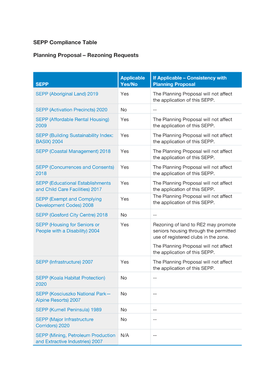
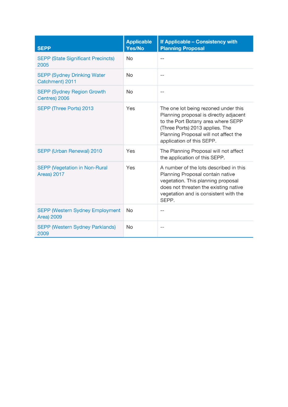
State Environmental Planning Policies
· SEPP (Housing for Seniors or People with a Disability) 2004
The Planning Proposal will not affect the application of SEPP (Housing for Seniors or People with a Disability) 2004.
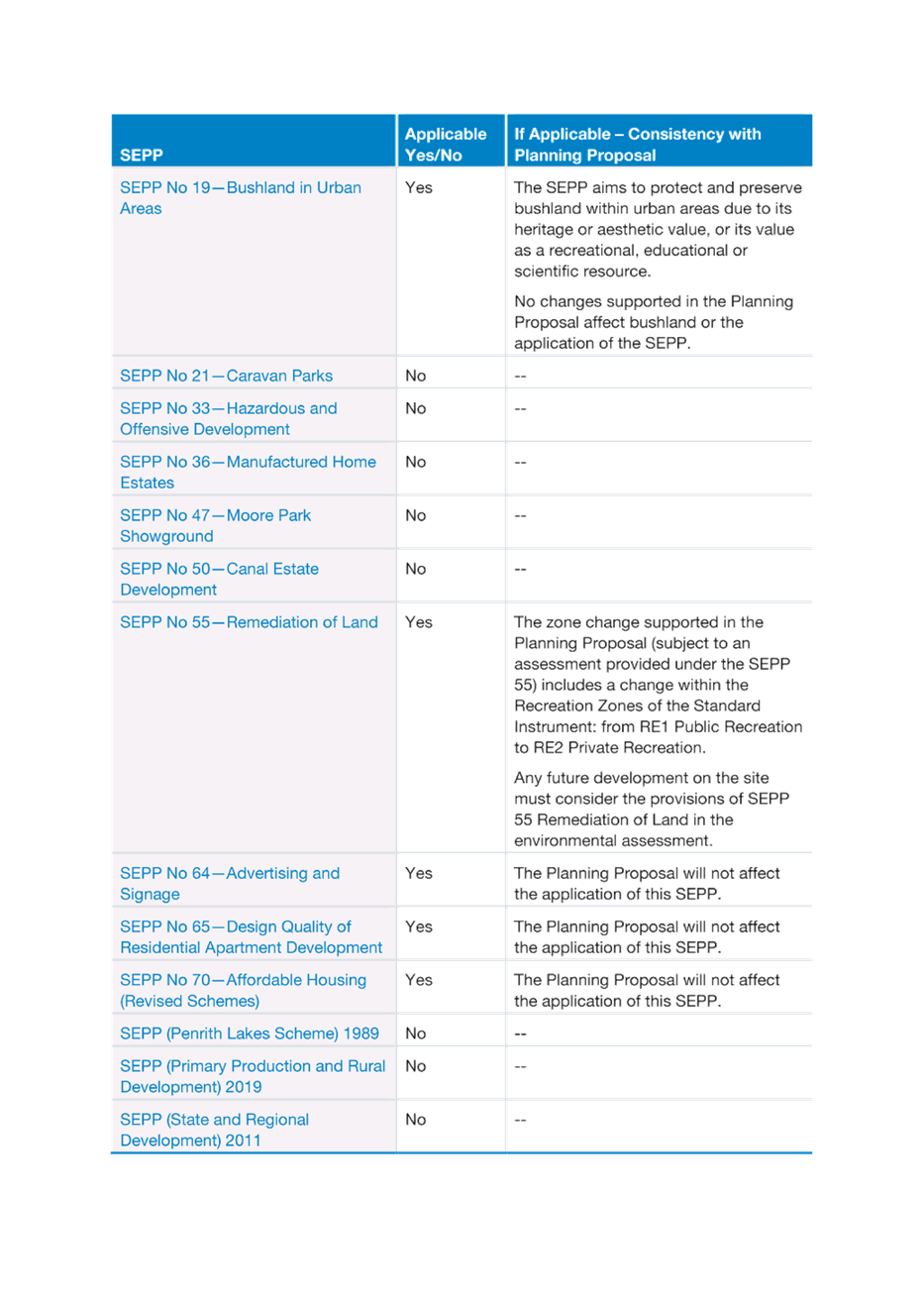
· SEPP 55 (Remediation of Land) 2008
Any future development on the site must consider the provisions of SEPP 55 Remediation of Land in the environmental assessment.
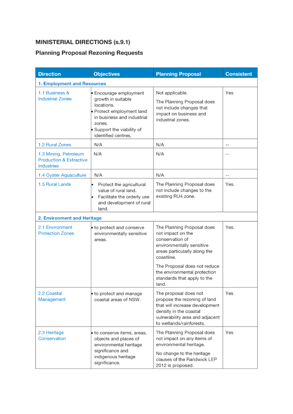
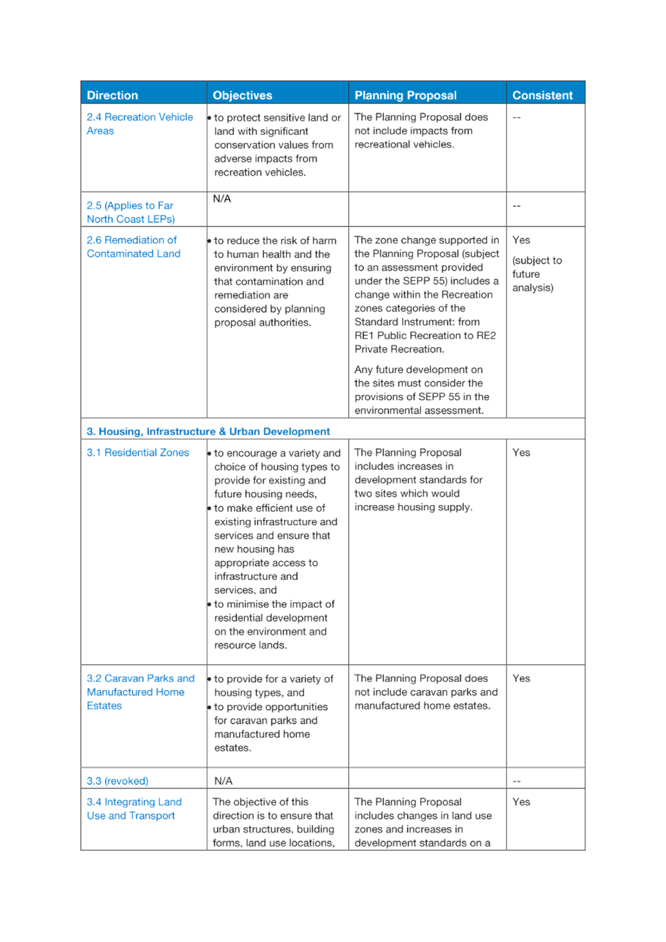
Ministerial Directions
An assessment of the Planning Proposal against the Ministerial Directions is provided in Attachment C. The Ministerial Directions relevant to the Planning Proposal are:
· 2.6 Remediation of Contaminated Land
The zone change supported in the Planning Proposal (subject to an assessment provided under the SEPP 55) includes a change within the Recreation zones categories of the Standard Instrument: from RE1 Public Recreation to RE2 Private Recreation.
Any future development on the sites must consider the provisions of SEPP 55 in the environmental assessment.
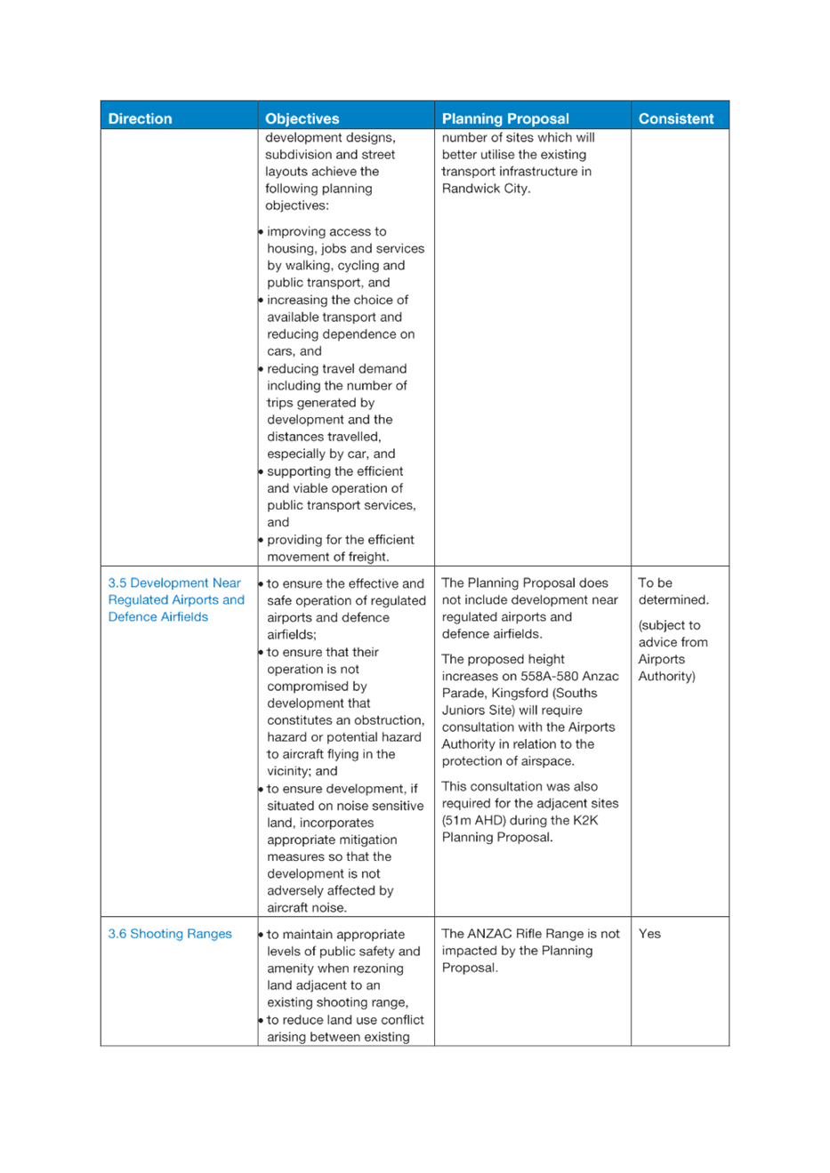
· 3.4 Integrating Land Use and Transport
The Planning Proposal includes changes in land use zones and increases in development standards on a number of sites which will better utilise the existing transport infrastructure in Randwick City.
· 3.5 Development Near Regulated Airports and Defence Airfields
The Planning Proposal does not include development near regulated airports and defence airfields. The proposed height increases on 558A-580 Anzac Parade, Kingsford (Souths Juniors Site) will require consultation with the Airports Authority in relation to the protection of airspace. This consultation was also required for the adjacent sites (51m AHD) during the K2K Planning Proposal.
· 4.1 Acid Sulfate Soils
The Planning Proposal does not propose the intensification of land uses within areas of identified as containing acid sulfate soils.
The Botany Road site proposed to be zoned from RE1 Public Recreation to RE2 Private Recreation is identified as Class 4 on the Acid Sulfate Soils Map. Future development on the site will need to consider clause 6.1 of the Randwick LEP 2012.
· 4.3 Flood Prone Land
The sites are not identified as a Flood Planning Area in the Randwick LEP 2012. Note – 1903R Botany Road, Matraville site has a waterway through the north of the site (addressed in Attachment A).
· 6.2 Reserving Land for Public Purposes
The Planning Proposal includes a site proposed to be rezoned from RE1 Public Recreation to RE2 Private Recreation which will remove the acquisition requirements under clause 5.1 of the Randwick LEP 2012 for the site. The site will retain a Recreation category zoning and will allow for landuses suitable to private recreation.
Planning Proposal
This report is seeking advice from the Randwick Local Planning Panel (RLPP) on the merits of the planning proposal and the proposed changes to the Randwick Local Environment Plan (LEP) 2012 in response to requests for site specific changes to the land use zone and development standards.
It is noted that a number of the rezoning requests received by Council will be considered in specific land use or area planning proposals (including Housing, Randwick Junction and Economic Development Planning Proposals) that will form part of the future Comprehensive Planning Proposal. These rezoning requests are not duplicated in this report.
This report considers the rezoning requests in three (3) categories: supported, not supported and recommended for further review.
The following four (4) sites are supported for changes to the Randwick LEP in relation to land use zone and/or development standards (maximum FSR and height) as considered in this report and in detail in Attachment A:
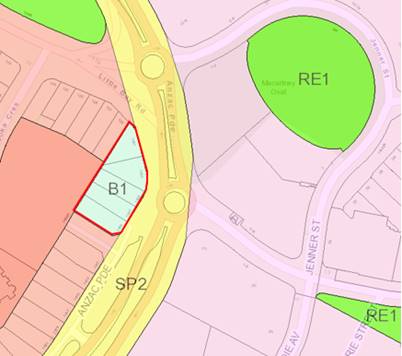
· 1903R Botany Road, Matraville
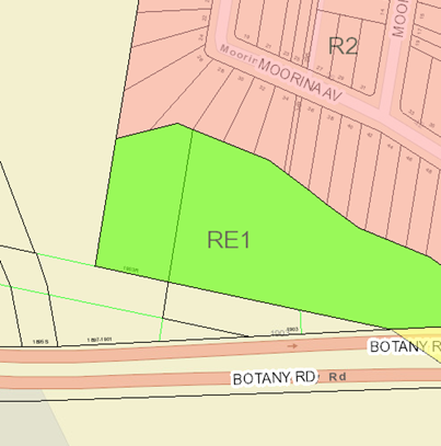
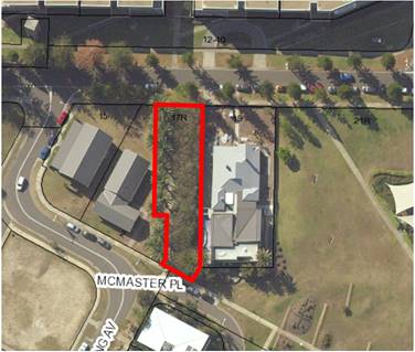
1903R is a 3358 square meter, vacant lot with no public road access, located near Botany Road in Matraville. The lot is under private ownership and is adjacent to the Port Botany industrial area. The Bunnerong Creek waterway runs directly through the northern section of the lot. To the north of the site is R2 Low Density Residential zoned land, to the west and south is industrial/port land, to the east is Council owned RE1 Public Recreation land.
The current, and previous landowners have in the past offered the site to Council for purchase in accordance with acquisition provisions of the Randwick LEP (as the land is zoned RE1). In June 2019, Council again stated it is not in a position to purchase the land.
|
Aerial photo of 1903R Botany Road, Matraville (the site) |
Land Use Zoning, 1903R Botany Road, Matraville (RE1 Public Recreation) |
|
|
Existing |
Requested |
|
Zoning |
RE1 Public Recreation |
RE2 Private Recreation |
|
Height |
No FSR Control |
No change |
|
FSR |
No Height Control |
No change |
The proposed zoning change has been requested by the landowner on the basis that Council has been unable to purchase the site, and that the land should be rezoned to reflect the fact that it is not intended or currently used for public recreation, and that the land is privately owned.
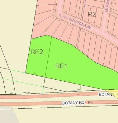
This rezoning request for the subject site to be zoned from RE1 Public Recreation to RE2 Private Recreation (refer Figure below) is supported based on its private ownership. No other map changes are proposed. This zoning change will expand the range of permissible land uses on the site to include take away food and drink premises and registered clubs (currently not permissible in the RE1 Public Recreation Zone).
|
Proposed Land Use Zoning, 1903R Botany Road, Matraville (RE2 Private Recreation) |
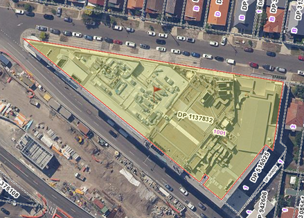
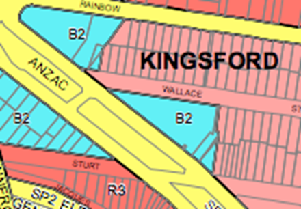
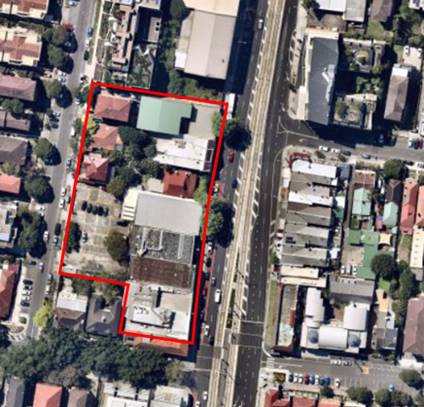
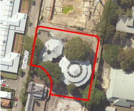
· 558A – 580 Anzac Parade, Kingsford (Souths Juniors)
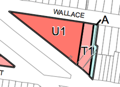
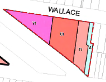
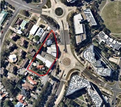
The Souths Juniors site (558A-580 Anzac Parade, Kingsford) is a triangular corner lot housing the South Sydney Junior Rugby League Club (Souths Juniors). The site is approx. 4,720m2, with a frontage to Anzac Parade of approx. 130m and Wallace Street of approx. 135m.
The Souths Juniors Club is a part 3, 4 and 5 storey building occupying the entire site (refer Figures below). The planning proposal application notes that the total floorspace of the existing club is close to 4:1. The Club has a primary frontage to Anzac Parade and relatively blank facade to Wallace Street, with few openings or articulation. The existing Souths Juniors building is a prominent feature on Anzac Parade and differs from the surround development in terms of height, bulk and form.
Adjoining properties to the east are commercial development fronting Anzac Parade and detached dwellings fronting Wallace Street. The site is located opposite the Juniors Kingsford Light Rail Terminus which serves as a dual transport interchange between light rail and buses.
The site is located within the K2K Planning Strategy area and subject to the recent LEP and DCP amendments.
|
Aerial photo of 558A – 580 Anzac Parade, Kingsford (the site) |
Land Use Zoning, 558A – 580 Anzac Parade, Kingsford (B2 Local Centre) |
|
|
Existing controls |
Requested controls |
|
Zoning |
B2 Local Centre |
No Change |
|
Height |
Heights of 31m, 25m & 1m under Clause 6.17 Community infrastructure height of buildings and floor space at Kensington and Kingsford town centres and Alternative Building Heights Map. |
Increase in the alternative building height on the western (apex) side of the site from 31m (approx. 9 storey) to 51m (approx. 15 storey) under Clause 6.17 Community infrastructure Height of Buildings and floor space at Kensington and Kingsford town centres and the Alternative Building Heights Map. The height increase (to 51m) would also enable the site to utilise Clause 6.21 Design excellence at Kensington and Kingsford town centres which would provide (subject to requirements) an additional 6m (approx. 2 storey) in height (ie up to 57m (approx. 17 storey). Refer to Attachment A for further details. |
|
FSR |
4:1 |
No change |
The proposed height increase (apex of the triangular site) is supported. Council notes and agrees with the urban design report and rationale attached to the submission.
The proposed tower would reinforce the building grouping around the Light Rail Stop and would not be out of place in this urban setting. Permitting a tower on this site would not set a precedent as the site is a one-off occurrence within the Kingsford Town Centre, on a large existing consolidated site with neighbouring properties on the eastern side (the boundary of which is not impacted by the proposed height increase).
The proponent’s proposal retains the LEP height controls on the east portion of the site, retaining the same transition in built form to the adjoining low scale residential properties to the east. The proponent does not request a change to the maximum 4:1 FSR permitted for the site. As there is no FSR change proposed, the impacts of the rezoning request are the potential impacts of the tower form on the Wallace Street and Anzac Parade intersection, including overshadowing to the south and west.
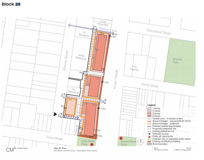
The K2K Strategy identified three (3) nodes for uplift across the two (2) town centre; one in Kensington and two (2) in Kingsford. The three (3) notes were selected based on their individual site capacity to accommodate larger buildings, define the gateway to the town centre being located adjacent to key transport infrastructure and provide community benefits.
The subject site falls in close proximity to the Kingsford Junction Precinct (one of the Kingsford nodes) and can contribute to the nodes approach by further reinforcing the end/entry to Kingsford, complimenting and reinforcing the uplift cluster on the southern edge of the town centre. The site is also opposite the transport interchange, and like the two (2) adjacent sites included in the southern node, the subject site is triangular with two long street frontages where the primary roads converge.
It is recommended that this site be included as a Key site on the Randwick Key Sites Map associated with clause 6.11 of the Randwick LEP 2012, which will require the preparation of site specific DCP chapter to address design implications for the site of the recommended maximum building height and maximum FSR changes. The other two node sites in this location are also key sites in the RLEP.
|
Existing Alternative Building Heights Map |
Proposed Alternative Building Heights Map |
The following is supported for 558A – 580 Anzac Parade, Kingsford:
· Zone: No change
· Maximum FSR: No change
· Maximum Height: increase on part of the site from 31m to 51m (Alternative Building Height Map)
· Design Excellence: clause 6.21 will apply to part of the site
· Key Sites: include the site in the Key Sites Map associated with clause 6.11 which will require the preparation of site specific DCP chapter to address design implications for the site of the recommended maximum building height and maximum FSR changes.
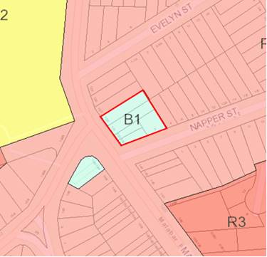
· 1401-1409 Anzac Parade, Little Bay
The subject site is located on Anzac Parade, Little Bay near the entrance to the Prince Henry Little Bay development. The site is known as 1401-1409 Anzac Parade and includes five (5) lots containing retail premises and residential accommodation. The total land area of the site is approx. 2,640m2 and a frontage to Anzac Parade of approx. 100m. The site contains single and two storey business and residential uses.
To the east of the site on the corner of Anzac Parade and Pine Avenue, within the Prince Henry Little Bay development, is four (4) and part five (5) storey mixed use development with ground floor retail land uses, with shop top housing above. This corner site is zoned R1 General Residential (consistent with the Prince Henry site) and has a maximum height limit of 15m and a maximum FSR of 1.2:1. To the rear of the site, on Mirrabooka Crescent is Land and Housing Corporation residential accommodation and single and two (2) storey dwelling houses fronting Little Bay Road via a slip road.
|
Aerial photo of 1401-1409 Anzac Parade, Little Bay (the site) |
Land Use Zoning, 1401-1409 Anzac Parade, Little Bay (B1 Neighbourhood Centre) |
|
|
Existing |
Requested |
|
Zoning |
B1 Neighbourhood Centre |
No change |
|
Height |
9.5m |
Increase to allow 4-5 storeys (ie 20m) |
|
FSR |
1:1 |
Increase unspecified |
· its key location and will compliment the existing four (4) and five (5) storey buildings opposite at the entrance to Prince Henry site,
· the increase in FSR and height will strengthen the neighbourhood business land uses in this location,
· the intersection of Little Bay Road and Anzac Parade is a significant location and provide access to the site from the north, south and west, increasing the catchment to which the B1 Neighbourhood Centre site services,
· the width of Anzac Parade and Little Bay Road supports higher density and heights,
· the public transport services operating along Anzac Parade.
The following is supported for 1401-1409 Anzac Parade, Little Bay:
· Zone: No change
· Maximum FSR: increase from 1:1 to 1.2:1
· Maximum Height: increase from 9.5m to 15m
· Key Sites: include the site in the Key Sites Map associated with clause 6.11 which will require the preparation of site specific DCP chapter to address design implications for the site of the recommended maximum building height and maximum FSR changes.
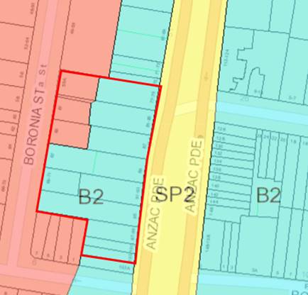
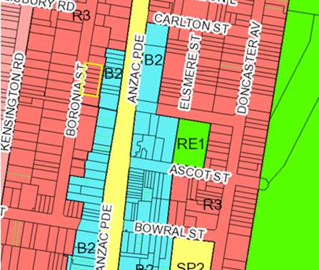
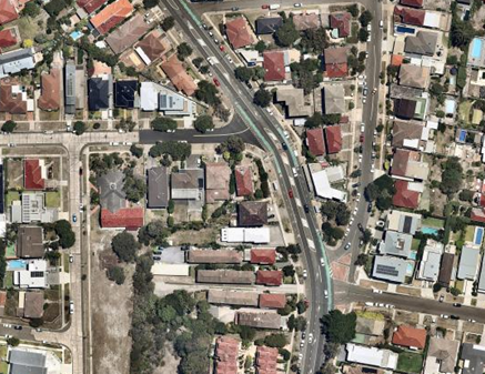
· 59A-71 Boronia Street and 77-103 Anzac Parade, Kensington (part supported)
The site consists of 14 lots with an area of approx. 6,410m2. Part of the site fronts Anzac Parade and is located within the Kensington Town Centre. The western side of the site fronts Boronia Street and is partly zoned B2 Local Centre and partly R3 Medium Density Residential (refer Figure below), consistent with the residential land in Kensington immediately to the north and west.
|
Aerial photo of 59A-71 Boronia Street and 77-103 Anzac Parade, Kensington (the site) |
Land Use Zoning, 59A-71 Boronia Street and 77-103 Anzac Parade, Kensington (B2 Local Centre and R3 Medium Density Residential) |
|
|
|
Existing |
Requested |
|
Zoning |
77-79 to 103 Anzac Parade and 67 to 69-71 Boronia Street, Kensington |
B2 Local Centre |
No change |
|
|
59A, 61, 63-65 and Boronia Street, Kensington
|
R3 Medium Density Residential |
B2 Local Centre |
|
|
81-85 Anzac Parade, Kensington |
Part B2 Local Centre and part R3 Medium Density Residential (battleaxe handle only). |
B2 Local Centre |
|
Height |
77-79 to 103 Anzac Parade and 67 to 69-71 Boronia Street, Kensington |
25m & 1m (strip) 31m (alternative height map) 9.5m (103 Anzac Parade) |
54m |
|
|
59A, 61, 63-65 and Boronia Street, Kensington |
12m |
54m |
|
|
81-85 Anzac Parade, Kensington |
Part 25m & 1m (strip) Part 31m (alternative height map) Part 12m (fronting Boronia) |
54m |
|
FSR |
77-79 to 103 Anzac Parade and 67 to 69-71 Boronia Street, Kensington |
No Max FSR FSR 4:1 (Alternative FSR Map) |
Flexible FSR |
|
|
59A, 61, 63-65 and Boronia Street, Kensington |
Max FSR 0.9:1 |
Flexible FSR (intended to remove 0.9:1 max) |
|
|
81-85 Anzac Parade, Kensington |
Part No Max FSR & FSR 4:1 (Alternative FSR Map) Part Max 0.9:1 (fronting Boronia) |
Flexible FSR |
In response to a previous request under the K2K Planning Proposal in late 2019, Council did not support changes to the maximum Height of Building (HOB), land use zone or FSR for the subject site. The recommendation below is consistent with the previous recommendation, other than (as discussed below):
· Request to amend the FSR for the residential properties fronting Boronia Street
· Request to remove the one (1) metre height limit through the rear of the Anzac Parade sites.
Extract from Randwick LEP Map (Alternative Building Heights)
Zoning Change
Council does not intent to extend the Kensington Town Centre B2 Local Centre zone. As such, Council does not support the rezoning of the three (3) residential lots fronting Boronia Street (and battleaxe of 81-85 Anzac Parade) from R3 Medium Density Residential lots to B2 Local Centre.
The Kensington Town Centre primarily fronts Anzac Parade, with several properties extending across the block to Boronia Street (and zoned B2 Local Centre) and provide alternative access for properties fronting Anzac Parade. The three (3) residential lots have only frontage to Boronia Street, with the residential development consistent with the character of the street.
FSR Change
The proposed removal of the maximum FSR of 0.9:1 from the three (3) properties fronting Boronia Street (and the battleaxe of 81-85 Anzac Parade) is supported, consistent with the development standard (FSR) to south of the site on Boronia Street where a site specific envelope control has been introduced in the K2K DCP Part B. It is recommended that the DCP be amended to include the three (3) residential lots in the block control drawings to ensure that these lots are considered in the overall development scheme for the land.
Height Change
Council’s urban design strategy for the town centres provides for a mid-rise building typology for most of the town centres to reinforce the spine with appropriate transition to existing development.
Higher building form for the subject land would result in a departure from the consistent approach established under the urban design strategy for the town centre.
The proposal to increase the maximum building height on the three (3) Boronia Street properties (zoned R3) from 12m to 54m is not supported. The proposal to increase the maximum building height on the Anzac Parade properties to 54m is also not supported.
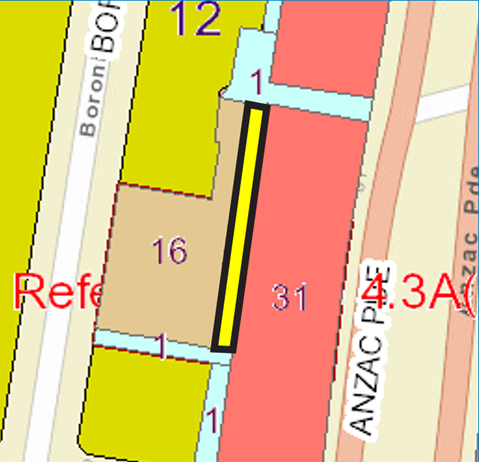
As noted above, there is a one (1) metre height limit strip running north south along the rear of the properties (highlighted yellow above), originally introduced to provide rear access for the Anzac Parade properties. Council has prepared and adopted block controls within the K2K DCP which was after gazettal of the LEP which outlines controls for addressing height distribution within this block, pedestrian and vehicular connections (see extract below).
Extract from K2K DCP (Block controls- Part B).
It is recommended that the maximum building height at the rear of the 95, 91-93, 89, 87 and 81-85 Anzac Parade properties be increased from one (1) metre to be consistent with the K2K DCP and other parts of the lots (i.e. Maximum 31m).
The following is supported for 59A-71 Boronia Street and 77-103 Anzac Parade, Kensington:
· Maximum FSR: Not include a maximum FSR standard for 59A, 61, 63-65 Boronia Street and 81-85 Anzac Parade (Part) and apply an envelope control under the K2K Block Controls – Part B.
· Maximum Height: increase the maximum from 1m to 31m for the strip of land at the rear of 95, 91-93, 89, 87 and 81-85 Anzac Parade, Kensington. No other height change is supported.
· Prepare a DCP Amendment to include the three (3) Boronia Street residential properties (and battleaxe of 81-85 Anzac Parade) in a future review of the K2K Block Controls – Part B.
· No change to the Land Use Zoning: Retain R3 Medium Density Residential Zone for 59A, 61, 63-65 and 81-85 Anzac Parade (Part).
Not Supported
The following seven (7) sites are not supported for changes to the Randwick LEP in relation to land use zone and/or development standards (maximum FSR and height) as considered in this report and in detail in Attachment A. These sites do not have site specific merit and/or do not align with the objectives of the strategic planning policy context:
· 59A-71 Boronia Street and 77-103 Anzac Parade, Kensington (part not supported)
Refer site description and recommendations in the section above.
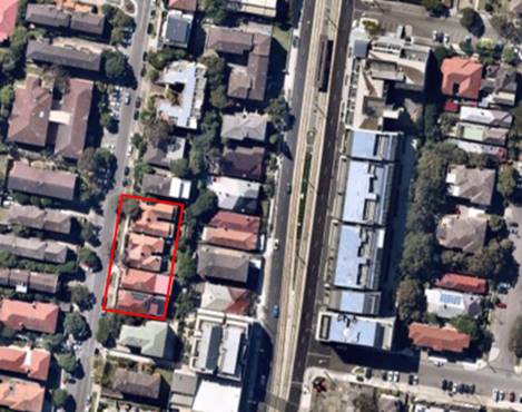
· 33-43 Boronia Street, Kensington
The subject site (33-43 Boronia Street, Kensington) include six (6) lots which have a combined area of approx. 1,530m2 and a street frontage of approx. 52m. The site includes six (6) single dwelling houses. Despite all structures appearing as single storey dwellings from street level, the sloped topography of the site results in the back of the properties being split level. Immediately to the east of the site is the B2 Local Centre area of Kensington Town Centre fronting Anzac Parade, at a significantly lower level than Boronia Street at this point. On the opposite (western) side of Boronia Street are medium density residential properties, up to three (3) storeys.
|
Aerial photo of 33-43 Boronia Street, Kensington (the site)
|
Land Use Zoning, 33-43 Boronia Street, Kensington (R3 Medium Density Residential) |
|
|
Existing |
Requested |
|
Zoning |
R3 Medium Density Residential |
B2 Local Centre |
|
Height |
12m |
14m |
|
FSR |
0.9:1 |
4:1 |
Council does not intent to extend the Kensington Town Centre B2 Local Centre zone. As such, Council does not support the rezoning of the six (6) residential lots fronting Boronia Street from R3 Medium Density Residential to B2 Local Centre.
The Kensington Town Centre primarily fronts Anzac Parade, with a number of properties extending across the block further south on Boronia Street (and zoned B2 Local Centre) and which provide alternative access for properties fronting Anzac Parade. The six (6) residential lots have only frontage to Boronia Street, with the residential development consistent with the character of the street.
The proposed increase in the Maximum FSR from 0.9:1 to 4:1 is also not supported. The 0.9:1 FSR maximum is consistent with that of the surrounding R3 Medium Density Residential zoned land in Boronia Street and further to the west.
Council’s urban design strategy for the town centres provides for a mid-rise building typology for most of the town centres to reinforce the spine with appropriate transition to existing surrounding residential development. Higher building form for the subject land would result in a departure from the consistent approach established under the urban design strategy for the town centre.
The proposal to increase the maximum building height on the six (6) Boronia Street properties from 12m to 14m is not supported as the 12m height limit is consistent with the surrounding R3 Medium Density Residential scale.
No change is recommended to the existing land use zone or development standards (height and FSR) for 33-43 Boronia Street, Kensington.
· 204 Malabar Road, South Coogee
The site is known as 204 Malabar Road, South Coogee and is located on the western side of Malabar Road near the corner or Nymboida Street. The site is approx. 890m2 and has 12m frontage to Malabar Road. The site contains a 2 storey attached dual occupancy which is permissible in the R2 Low Density Residential zone. The request was submitted by the private land owner.
The surrounding land use is mainly R2 Low Density Residential, with a small section of R3 Medium Density Residential to the south, occupied by community/government housing.
|
Aerial photo of 204 Malabar Road, South Coogee (the site)
|
Land Use Zoning, 204 Malabar Road, South Coogee (R2 Low Density Residential) |
|
|
Existing controls |
Requested controls |
|
Zoning |
R2 Low Density Residential |
R3 Medium Density Residential |
|
FSR |
0.5:1 |
0.9:1 |
|
Height |
9.5m |
12m |
Malabar Road and South Coogee is not an area identified for housing growth in the LSPS and Housing Strategy. The site does not fall within those being further investigated as part of town centres and strategic centres buffer areas (refer below) as it is not located near a B2 Local Centre or a Strategic Centre as specified under the Actions of the Housing Strategy.
A change in land use zone for the subject site (a single lot surrounded by R2 Low Density Residential land) is not supported in isolation. The built form of 204 Malabar Street, South Coogee is consistent with the surrounding R2 Low Density Residential land use zoning.
The reference to the townhouse development (206 – 216 Malabar Road) is an isolated site, surrounded by RE1 Public Recreation and zoned consistent with the R3 Medium Density Residential located further to the south.
No change is recommended to the existing land use zone or development standards (height and FSR) for 204 Malabar Road, South Coogee.
· 7 Kenneth Lane and 52-56 Middle Street, Kingsford
The lots collectively are approx. 2,210m2 with a frontage width of 37.22m. The site has no considerable strategic significance or heritage protections.
|
|
|
|
|
Existing controls |
Requested controls |
|
Zoning |
R2 Low Density Residential |
R3 Medium Density Residential |
|
FSR |
0.5:1 |
(unspecified) |
|
Height |
9.5m |
(unspecified) |
This rezoning request was received as part of the 2012 Comprehensive LEP review as a late request. Since the 2012 Review, Council has prepared a Housing Strategy which strategically analysed the residential zoned land throughout Randwick City and identified Housing Investigation Areas for upzoning. These areas are focused around town and strategic centres, close to transport, jobs and services. The site was not included in the Housing Investigation Areas.
Due to historic development, including the scattered locations of the walk-up flats, the existing development on a number of lots in Randwick City is inconsistent with the adjoining land and the current land use zone. Council is not supporting adhoc rezonings to rectify these isolated zoning anomalies.
Council notes this request and the inconsistencies between the current LEP controls of the site and its existing built form of 54-56 Middle Street. Inconsistencies like these are common across Randwick City and are not grounds for granting a rezoning request. Only 56 & 54 Middle Street are inconsistent with the LEP zone, whilst 52 Middle Street and 7 Kenneth Lane, meets the objectives of the R2 LEP zone.
North-East Kingsford is not an area identified for medium density housing growth in the Randwick LSPS or Housing Strategy. Therefore, a spot rezoning of this site is not supported by Council.
No change is recommended to the existing land use zone or development standards (height and FSR) for 7 Kenneth Lane and 52-56 Middle Street, Kingsford.
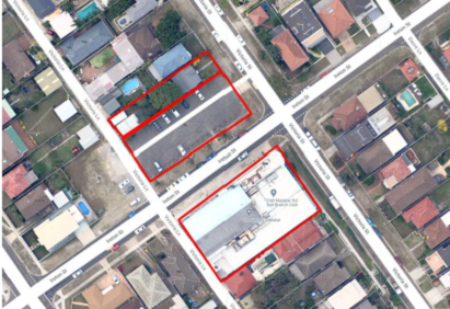
· 22-30 Victoria Street, Malabar (Souths Juniors, Malabar)
The subject site is 22-30 Victoria Street, Malabar and is separated by Ireton Street. The site includes seven (7) lots all owned by The South Sydney Juniors Rugby League Club, which is the applicant for this rezoning request.
28 Victoria Street has a combined area of approximately 1,490m2 and contains the existing Souths Juniors Club building (part 2, part 3 stories) located on the northern part of the block bounded by Victoria Street, Victoria Lane and Ireton Street.
24-26 Victoria Street is located on the southern side of Ireton Street and consists of a carpark opposite the Souths Club to provide parking for patrons. 22 Victoria Street is a single storey, freestanding dwelling. This southern side of the site has a combined area of approximately 1500m2.
The site is located in the low density residential neighbourhood of Malabar, surrounded by single and two (2) storey dwelling houses.
|
Aerial photo of 22-30 Victoria Street, Malabar (Souths Juniors Malabar) (the site) |
Land Use Zoning, 22-30 Victoria Street, Malabar (Souths Juniors Malabar) (R2 Low Density Residential) |
|
|
Existing controls |
Requested controls |
|
Zoning |
R2 Low Density Residential |
R3 Medium density residential |
|
FSR |
0.5:1 |
Unspecified |
|
Height |
9.5m |
12m |
As noted in the submission, the site could utilise the provisions of the Seniors SEPP and seek a site compatibility certificate. The Randwick Housing Strategy (Housing Priority 2) has identified the need to provide housing for seniors and retirement care facilities for the future needs of an ageing population.
No change is recommended to the existing land use zone or development standards (height and FSR) for 22-30 Victoria Street, Malabar (Souths Juniors, Malabar).
· 27 Jennifer Street, Little Bay
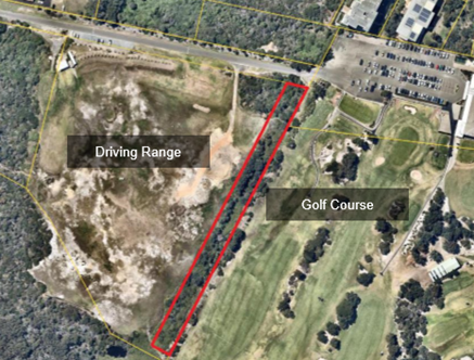
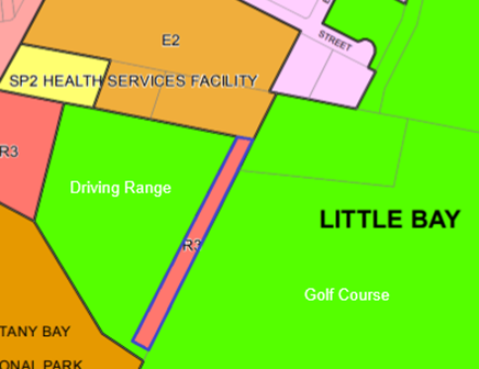
27 Jennifer Street is a long rectangular shaped strip located in Little Bay, between the St Michaels Golf Club and the Driving Range.
Immediately south of the site is the Kamay Botany Bay National Park. The subject site does not have direct access to Jennifer Street, which is 300m to the west of the site. Access to the site is from the adjacent Crown Land reserve which is used as the access to the Golf Course and car park.
The property is effectively land locked as no easement has been granted in favour of this property. The width of the land is approximately 18m, the length of the lot is approx. 265m and the total land area is approximately 4,830m2.
The site is in a unique coastal landscape environment, with some distance to the nearest residential area along Jennifer Street. The lot is unimproved and covered by native vegetation. The endangered ecological community Eastern Suburbs Banksia Scrub is found at the southern and western sides of the land within the National Park.
The lot remains undeveloped and vacant despite multiple DA’s over time that have been either rejected or withdrawn. The most recent application (DA/133/2018) for Torren subdivision into nine allotments was withdrawn.
A rezoning request was submitted by CityPlan on behalf of St. Michael's Golf Club (SMGC), the adjacent landowner. The lot is under private ownership, unconnected to SMGC.
|
(the site) |
(R3 Medium Density Residential) |
|
|
Existing controls |
Requested controls |
|
Zoning |
R3 Medium Density Residential |
RE1 Public Recreation |
|
FSR |
0.75:1 |
Not specified / not relevant to the request |
|
Height |
9.5m |
Not specified / not relevant to the request |
The request that Council rezone the land from R3 Medium Density Residential to RE1 Public Recreation is on the basis that residential development is incongruous with the surrounding open space and recreation uses, and any future residential use of the land would give rise to conflicts including public safety concerns with existing adjoining golf course operations such as errant golf balls striking future property.
The site is not suitable for standalone piece of local open space that would operate separate from the adjacent golf course uses. The value and useability of this land as public open space to the community is limited and constrained given its location adjoining the golf course and driving range. Furthermore, the land does not connect to existing areas of public open space. Therefore, rezoning to public open space (RE1 Public Recreation) is not supported unless the land is acquired and forms part of the larger Golf Course lands.
A public open space zone is not supported as this would trigger the acquisition provisions of the Randwick LEP and as noted above and the site is not suitable as a standalone piece of local open space. As a further note, the access road to the private golf club does not provide access to to this site. The owner of the subject land would be responsible for securing an easement over the driveway from the Crown.
No change is recommended to the existing land use zone or development standards (height and FSR) for 27 Jennifer Street, Little Bay. Given the site’s constraints surrounded by land owned by the Crown (golf courses and National Park) including that the land does not have formal access, it is appropriate that Council write to the NSW Government in relation to the future acquisition of the site to enable it to be incorporated with the surrounding National Park or golf course.
Recommendation: That Council write to the NSW Government in relation to the potential future acquisition of 27 Jennifer Street, Little Bay site and its integration into the adjacent National Park or golf course.
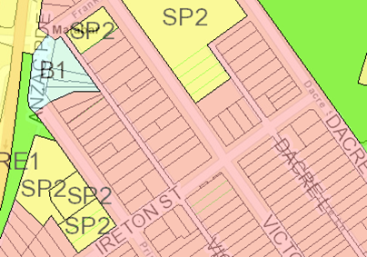
· 129-135 Malabar Road and 2 Napper Street, South Coogee
The subject site is known as 129-135 Malabar Road and 2 Napper Street and includes five (5) lots with a combined total area of approx. 1580m2. The current built form of the site includes two (2) corners shops and three (3) dwelling houses.
The site contributes to the eastern side of the South Coogee Neighbourhood Centre, with retail premises on the opposite side of Malabar Road also zoned B1 Neighborhood Centre with a maximum height of 9m and maximum FSR of 1:1.
The site is adjacent to Randwick Cemetery.
|
Aerial photo of 129-135 Malabar Road and 2 Napper Street, South Coogee (the site) |
Land Use Zoning, 129-135 Malabar Road and 2 Napper Street, South Coogee (B1 Neighbourhood Centre) |
|
|
Existing controls |
Requested controls |
|
Zoning |
B1 Neighbourhood Centre |
No change |
|
FSR |
1:1 |
1.5:1 |
|
Height |
9.5m |
12m |
There are a number of B1 Neighbourhood Centre zones in the Randwick LEP which provide retail and services for the immediate neighbourhood and at a scale consistent with the surrounding residential area. In this case, the surrounding residential area is primarily zoned R2 Low Density Residential with a maximum FSR of 0.5:1 and maximum height of 9.5m.
The following neighbourhood centres are comparable with the size and character of the subject site and also have consistent height (9.5m) and FSR (1:1) development standards applying, including:
· Neighbourhood Centre at 197-203A Malabar Road and 92 Denning Street, Coogee
· Neighbourhood Centre at 307-327 Malabar Road, Maroubra
· Neighbourhood Centre at 327-333 Maroubra Road, Maroubra
A Planning Proposal – Economic Development is being considered at the same RLPP meeting and recommends the inclusion of a number of new B1 Neighbourhood Centres, the majority with a consistent height (9.5m) and FSR (1:1).
The examples provided in the submission differ in character and size and are not comparable with the subject site, and include:
· Frenchmans Road Neighbourhood Centre, Randwick (Frenchmans Road and Clovelly Road),
· Clovelly Neighbourhood Centre (Clovelly Road and Mount Street, Clovelly),
· The Spot Neighbourhood Centre (Perouse Road and St Pauls Street, Randwick).
No change is recommended to the existing land use zone or development standards (height and FSR) for 129-135 Malabar Road and 2 Napper Street, South Coogee.
A further ten (10) rezoning requests have been deferred to planned future strategic studies (including the Town and Strategic Centres Transition and Buffer Areas Review and Eastgardens-Maroubra Junction Strategic Centre Review) to ensure a holistic and consistent review process for these areas as considered in this report and in detail in Attachment A.
· Town and Strategic Centres Transition and Buffer Areas Review
The Randwick Housing Strategy includes Planning Priority 3 – Focus growth in and around town and strategic centres close to transport, jobs and services. The Housing Strategy identified five (5) Housing Investigation Areas (HIAs) where changes to land use zones and development standards (building height and FSR) are proposed to provide for the medium term (6-10 year) housing supply for Randwick City. The areas being considered in the Town and Strategic Centres Transition and Buffer Areas Review fall outside these identified Housing Investigation Areas. The Housing Strategy also identified housing supply opportunities through the review of dual occupancy provisons and minimum lot size controls.
The Housing Strategy highlights the importance residential areas surrounding town centres which support the economic function of town and strategic centres. The Strategy identifies the need to examine the residential areas around town centres and strategic centres to ensure an appropriate built form transition.
The following sites will be included in the future review and considered strategically, consistent with both the Randwick LSPS (Action 9.4) and Housing Strategy (Action 3.2) as detailed in Attachment A:
· 29-45 Willis Street & 40 Middle Street, Kingsford
· 217 Anzac Parade, Kensington
· 2 and 4 Harbourne Road, Kensington
· 6 Harbourne Road, Kensington
· 80-82 St Pauls Street, Randwick
· 1A Bradley Street, Randwick
· 104-110 Todman Avenue, Kensington
· 151-153 Perry Street, Matraville
· Eastgardens-Maroubra Junction Strategic Centre Review
The Eastgardens-Maroubra Junction Strategic Centre is a strategic centre in the District Plan straddling both Randwick and Bayside LGAs. Investigation of the current and potential future economic and social roles of the combined centre, and implications for land use and transport planning has been identified in the Randwick LSPS. The LSPS identified the following key challenges and opportunities for planning for the Eastgardens-Maroubra Junction Strategic Centre:
· Identifying a cohesive economic role that unifies Eastgardens and Maroubra Junction as a stand-alone centre given these centres currently operate independently with contrasting place qualities, mix of uses and roles within the local community,
· Ensuring adequate transport connectivity to facilitate the efficient movement of workers and residents in this emerging centre,
· Planning for growth in an environment of uncertainty with respect to State level commitments to transport infrastructure funding, provision and delivery timeframes,
· Balancing the different objectives and priorities that Bayside and Randwick City may have for the new centre,
· Identifying place characteristics along the corridor as a basis for determining appropriate urban design responses, liveability outcomes, public domain improvements and respecting the relationship of new development to existing development including interface with lower scale residential and other uses; and
· Protecting and enhancing significant spaces and strengthening green infrastructure and sustainability in the centre. Transport infrastructure provision into and within this Centre is critical to its future economic development potential, productivity, functionality and sustainability.
The following sites will be included in the future review as detailed in Attachment A:
· 946 Anzac Parade, Maroubra Junction (Souths Juniors, Maroubra Junction),
· 100 Boyce Road, Maroubra.
All the rezoning requests considered in this report are proposed to be included in the future Comprehensive Planning Proposal.
An assessment of the rezoning request for each of the subject sites has been undertaken in accordance with the Department of Planning Industry and Environment’s (DPIE) Guide to Preparing Planning Proposals. The assessment has included the proposals consistency with Greater Sydney Region Plan (A Metropolis of Three Cities), Eastern City District Plan and LSPS as summarized above. A summary of subject sites and recommended changes is provided below and in the Tables in Attachment A.
Strategic alignment
The relationship with the City Plan is as follows:
|
Outcome/Direction |
Delivery Program actions |
|
Outcome |
6. A liveable city. |
|
Direction |
6d. A stategic land use framework provides for our lifestyle changes and for a continuing, yet steady rate of growth across our City. |
Resourcing Strategy implications
The review, data collection and analysis of the rezoning requests received was completed in-house by Strategic Planning officers with assistance from Consultant Strategic Planners.
Conclusion
Since the introduction of the current RLEP 2012 and recent planning amendments to the Kingsford and Kensington Town Centres, a number of rezoning requests have been received by Council. In accordance with policy approach of the State Government’s Standard Instrument LEP, Councils are encouraged to consider rezoning requests strategically rather than adhoc proposals.
This report has considered the rezoning requests received by Council since the introduction of the Randwick LEP in 2012 and during the consultation for the Randwick LSPS and Housing Strategy as well as submissions received in response to the K2K consultations. An assessment of each rezoning request has been undertaken in accordance with the Department of Planning Industry and Environment’s (DPIE) Guide to Preparing Planning Proposals and consistency with Greater Sydney Region Plan (A Metropolis of Three Cities), Eastern City District Plan, Randwick LSPS and Housing Strategy. This assessment has categorised the 20 rezoning requests into three (3) groupings: supported (4 sites – one part supported), not supported (7 sites – one part supported) and recommended for further review (10 sites).
The strategic review of the Randwick LEP will be undertaken through the Comprehensive Planning Proposal, which will be informed by the recommendations of this Planning Proposal – Rezoning Requests.
Of the four (4) requests being supported, one is zone change to reflect the private ownership of the open space land, the three (3) remaining are changes to the development standards better respond to the requirements of the Apartment Design Guide and the Block Controls of the Kensington Town Centre DCP – Part B. Two of the sites (Souths Juniors and B1 in Little Bay) have also been recommended for inclusion on the Key Sites Map associated with clause 6.12 of the Randwick LEP which will require a site specific DCP to be prepared. The increase in height and FSR for the B1 site in Little Bay will provide for development consistent with the urban context.
The majority of sites where the zoning and/or development standards not being supported are proposing changes to residentially zoned land. Consistent the State Government’s Regional and District Plans, the Randwick LSPS and Randwick Housing Strategy, future housing growth over the medium term (6-10 years) has been strategically identified through an analysis of the housing supply and demand and the most suitable locations for future housing. This has included the Housing Investigation Areas, Diversity Area (small lots) and a review of dual occupancy provisions which are the subject of a separate Planning Proposal. The proposed residential zone changes and increases to development standards (height and FSR) in this report have not been identified in the Housing Strategy’s strategic analysis and are therefore not recommended for change.
In addition, the Planning Proposal – Economic Development report (being considered at the same RLPP meeting) considers additional B1 Neighbourhood Centre zones and recommended height and FSR controls for these smaller clusters. The rezoning request to increase the height and FSR for the Malabar Road/Napper Street B1 site has not been supported in this report, as the existing development standards are consistent with those being recommended in the Economic Development report.
In February 2020, Council endorsed the Randwick Local Strategic Planning Statement (LSPS) as required under the Environmental Planning and Assessment Act 1979 (the EP&A Act) and the Eastern City District Plan. The Randwick (LSPS) sets the Directions and Planning Priorities for the next 20 years and sets the framework for land use planning for Randwick City. The LSPS, along with the State Government Plans and Council’s Housing Strategy, will be used to update the key components of the Randwick LEP in relation to land use planning and infrastructure delivery.
The remaining ten (10) rezoning requests have been deferred to planned future strategic studies (including the Town and Strategic Centres Transition Heights Review and Eastgardens-Maroubra Junction Strategic Centre Review) to ensure a holistic and consistent review process for these areas.
This report is seeking advice from the Randwick Local Planning Panel (RLPP) on the merits of the planning proposal and the proposed changes to the Randwick Local Environment Plan (LEP) 2012 in response to requests for site specific changes to the land use zone and development standards.
All the rezoning requests considered in this report are proposed to be included in the future Council report on the Comprehensive Planning Proposal scheduled to be reported in May 2021.
Responsible officer: Leonardo Shaw-Voysey, Student Environmental Planning Officer; David Appleby, Senior Strategic Planner; Kerry Longford, Strategic Planning Consultant
File Reference: F2020/00203
|
General Report No. GR5/21
|
|
Subject: Randwick Comprehensive Planning Proposal - Economic Development |
Executive Summary
· This report outlines a number of proposed amendments to the Randwick Local Environmental Plan 2012 (RLEP 2012) to implement key planning priorities relating to economic development, employment lands, short term rental accommodation and the night time economy under the Randwick Local Strategic Planning Statement (LSPS) and to give effect to the Eastern District Plan directions for strategic centres, health and education precinct and Innovation Corridor.
· The proposed RLEP 2012 amendments include:
o A number of measures to activate and diversify the night time economy to implement recommendations of the Randwick City Night Time Economy Study encompassing: new land use objectives for the B1 Neighbourhood Centre and B2 Local Centre zones on supporting a diverse, safe and inclusive night time economy, new exempt development criteria permitting later trading for shops and low impact businesses and small scale cultural activities in business zones without requiring development consent, and permitting galleries and maker spaces in residential zones with development consent;
o Exempt development criteria limiting the operation of unhosted short term rental accommodation to 90 days in the calendar year as a measure to manage impacts on rental housing supply, amenity, local character and sense of community;
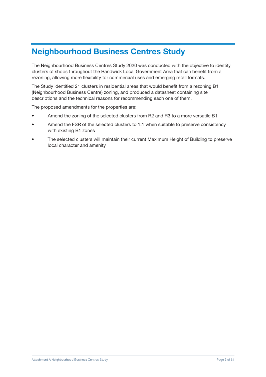
o Rezoning of 20 existing clusters of shops across Randwick City from residential to B1 Neighbourhood Centre zone to recognise existing land uses, facilitate greater certainty about zoning and land use permissibility, protect employment lands and facilitate walkable neighbourhoods with easy access to shops and services;
o Rezoning of the Randwick Hospital Campus expansion area from R2 Low Density Residential/R3 Medium Density Residential to SP2 Health Services Facility with revised heights to recognise State Government investment into new health, education and research facilities;
o Rezoning of the light rail stabling facilities at the Royal Randwick Racecourse from RE1 Public Recreation to SP2 Infrastructure to reflect existing infrastructure uses on the site.
· The proposed changes to zoning, development standards (building height and FSR) and exempt development provisions outlined in this report will be incorporated into a comprehensive planning proposal seeking amendments to the RLEP 2012 which will be reported to Council in May 2021.
|
That the Randwick Local Planning Panel advises Council that it supports the recommendations set out below:
a) Amend the RLEP 2012 to introduce an objective for the B1 Neighbourhood Centre and B2 Local Centre zones on supporting a diverse, safe and inclusive night time economy;
b) Amend the RLEP 2012 to introduce Exempt Development Provisions to permit shops, business premises and kiosks located in the B1 Neighbourhood Centre and B2 Local Centre zones to trade from 7am to 11pm without requiring development consent, subject to criteria on noise, parking, loading and waste management;
c) Amend the RLEP 2012 to introduce Exempt Development provisions allowing small scale cultural activities to occur in office, retail, business, restaurants, cafes and/or community facilities in the B1 Neighbourhood Centre and B2 Local Centre zones without requiring development consent subject to criteria on patron numbers, hours of operation, noise and amenity impacts.
d) Amend clause 6.13 of the RLEP 2012 to include ‘information and education facility” as a permitted use with development consent in the R1 General Residential, R2 Low Density and R3 Medium Density zones.
e) Amend the RLEP 2012 to introduce Exempt Development provisions permitting non-hosted short term rental accommodation without requiring development consent for 90 days per calendar year;
f) Amend the RLEP 2012 as follows:
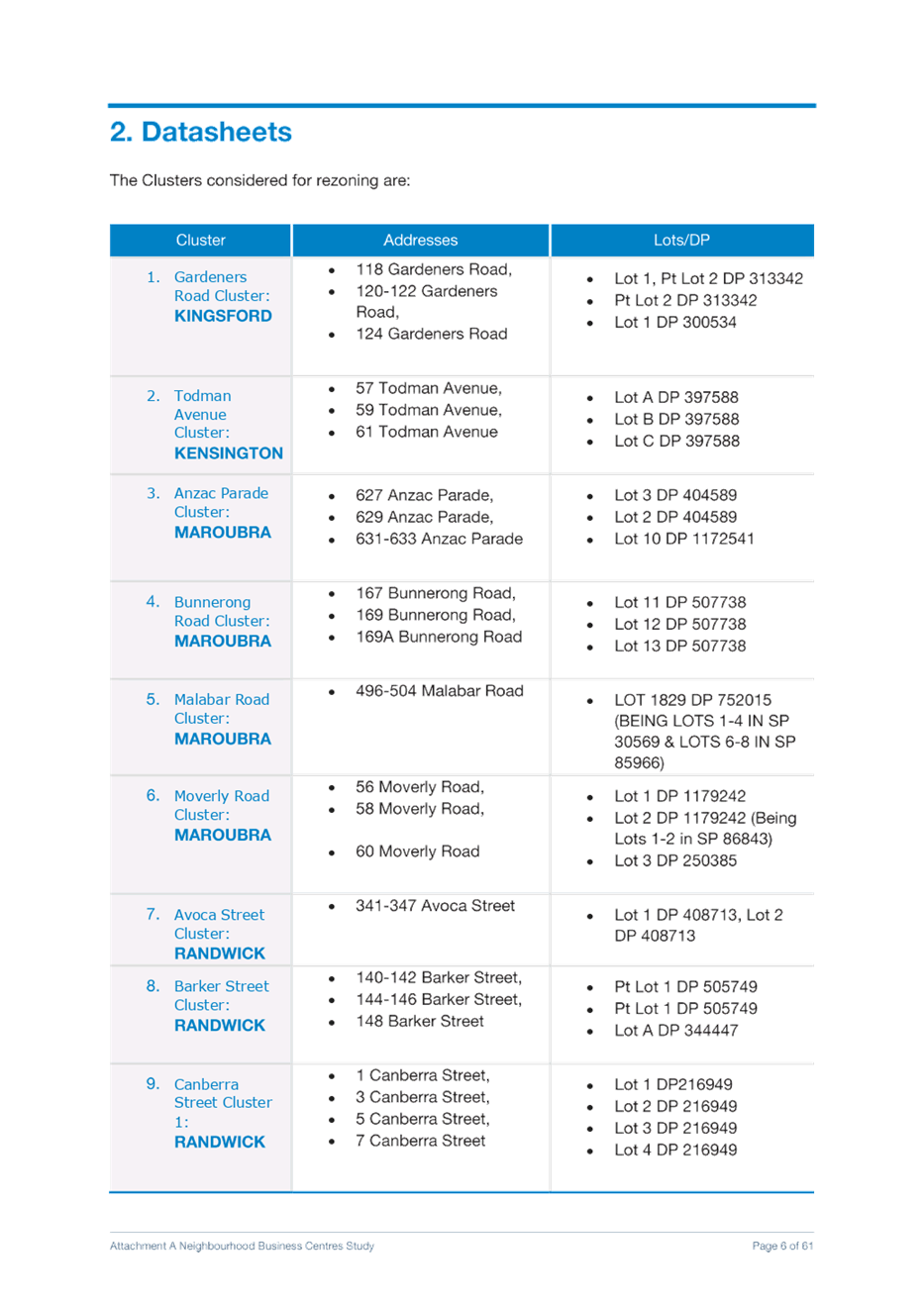
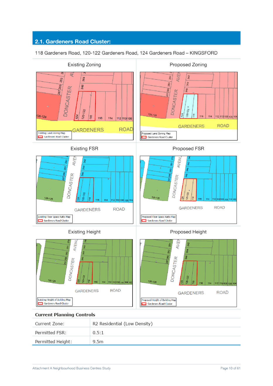
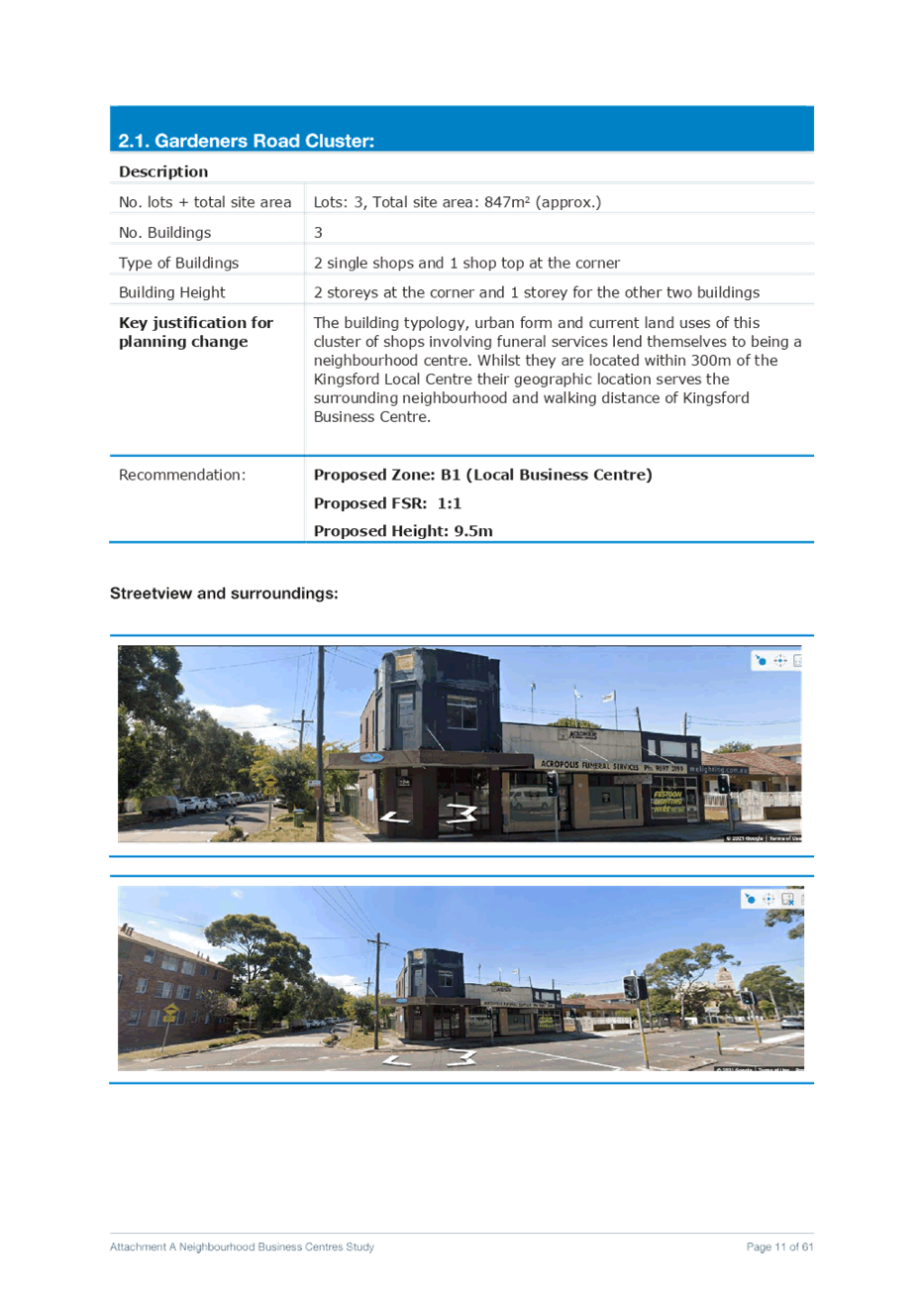
a. Gardeners Road Cluster Rezone 118 Gardeners Road, 120-122 Gardeners Road, and 124 Gardeners Road – KINGSFORD from R2 Low Density Residential to B1 Neighbourhood Centre with an applicable FSR of 1:1
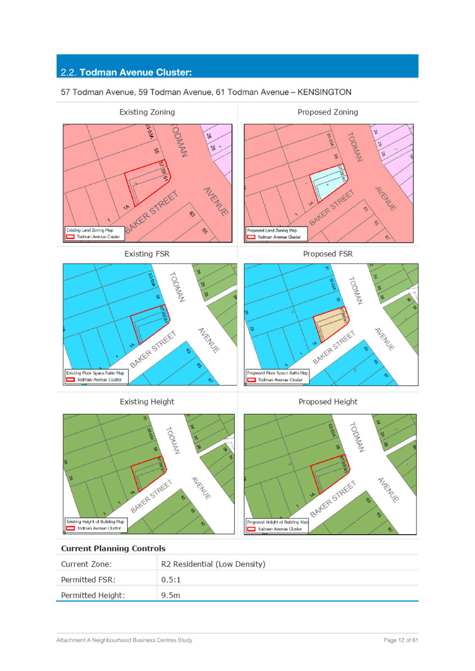
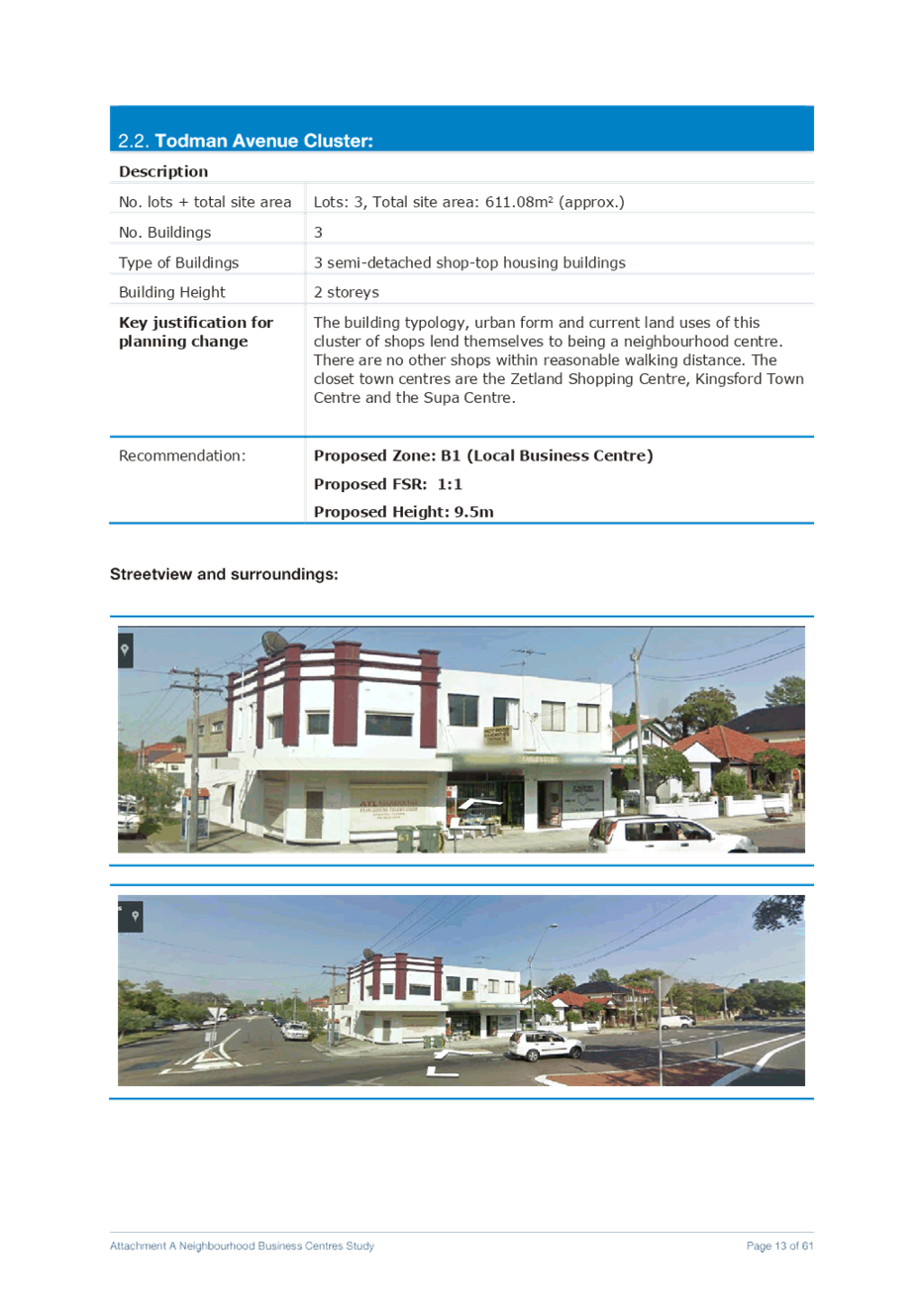
b. Todman Avenue Cluster Rezone 57, 59 and 61 Todman Avenue, KENSINGTON from R2 Low Density Residential to B1 Neighbourhood Centre zone with an applicable FSR of 1:1
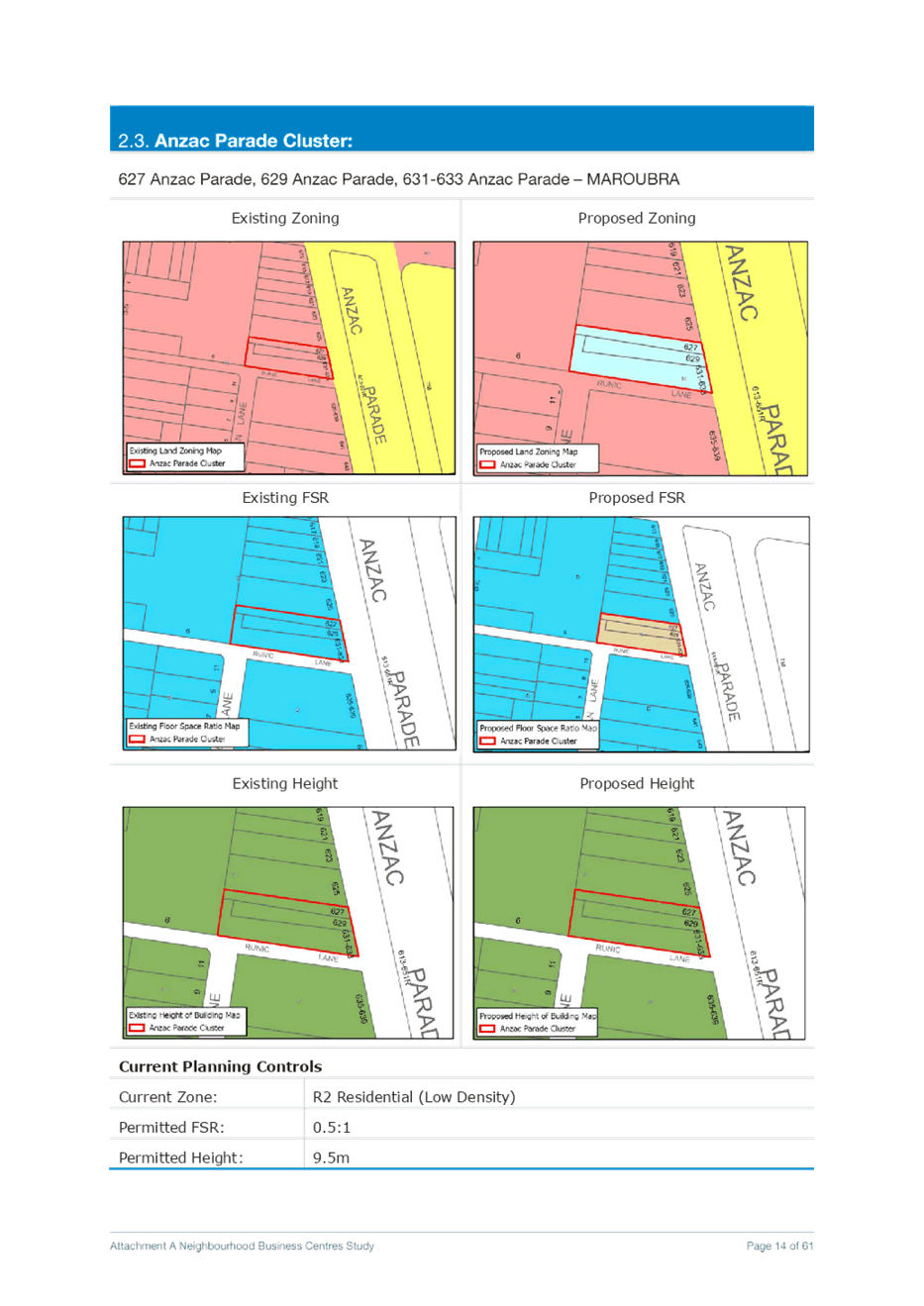
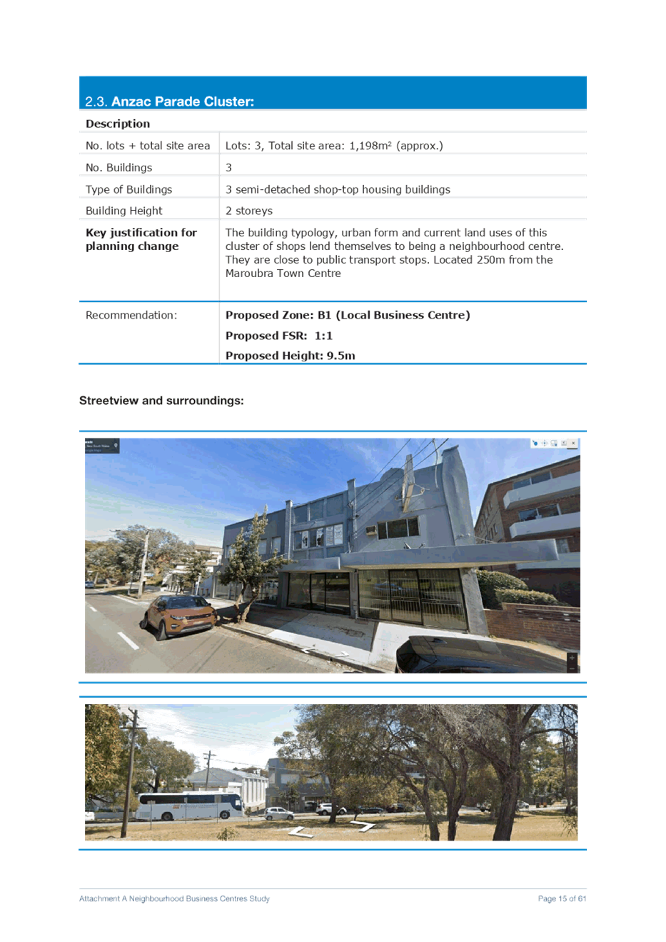
c. Anzac Parade Cluster Rezone 627 Anzac Parade, 629 Anzac Parade, and 631-633 Anzac Parade – MAROUBRA from R2 Low Density Residential to B1 Neighbourhood Centre with an applicable FSR of 1:1
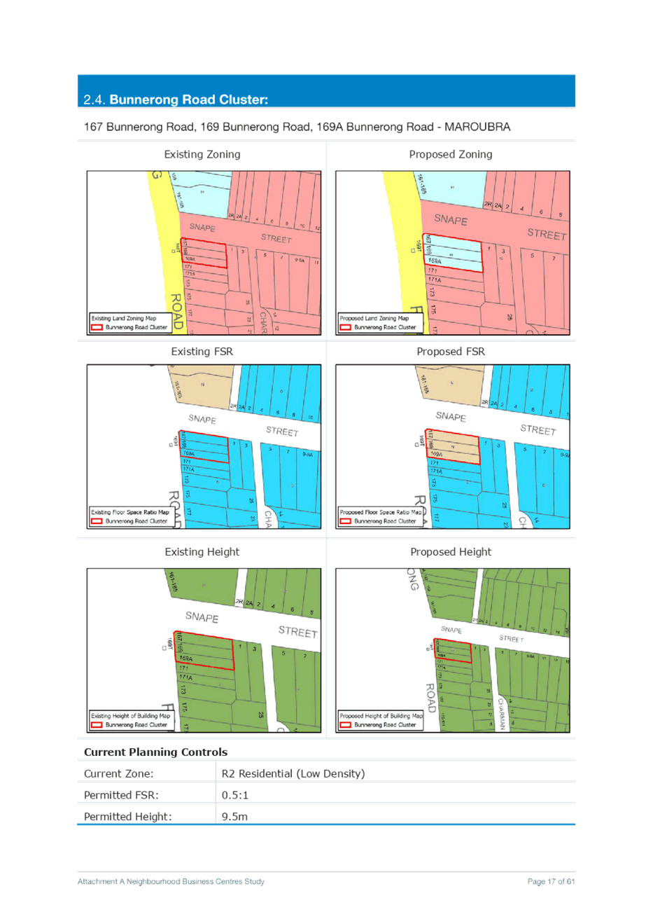
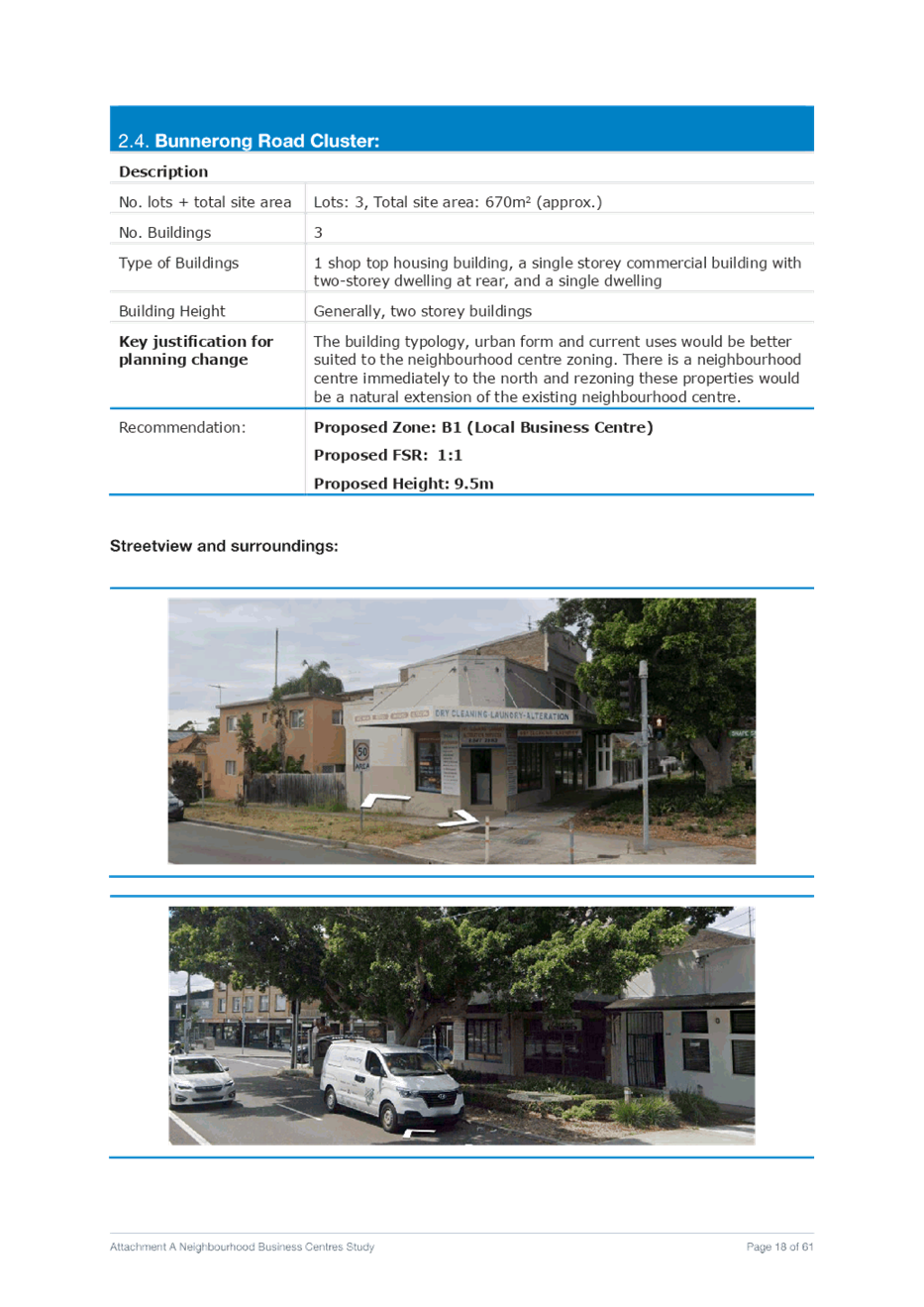
d. Bunnerong Road Cluster Rezone 167 Bunnerong Road, 169 Bunnerong Road, and 169A Bunnerong Road - MAROUBRA from R2 Low Density Residential to B1 Neighbourhood Centre with an applicable FSR of 1:1
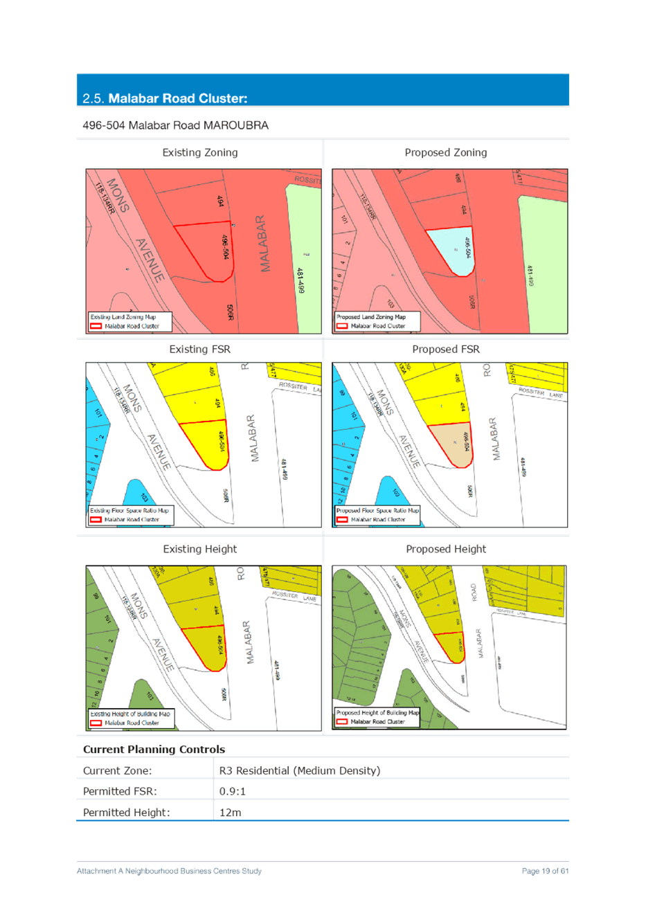
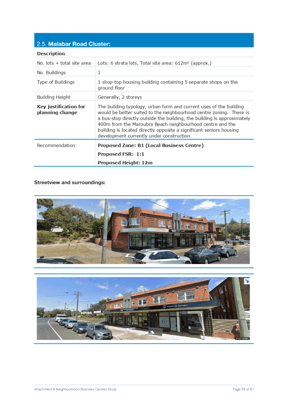
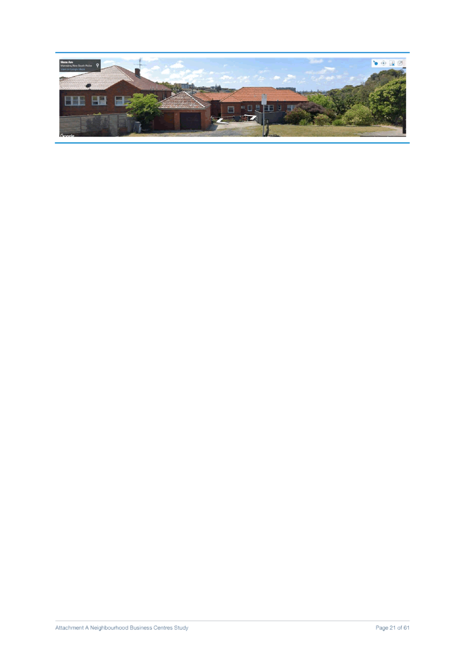
e. Malabar Road Cluster Rezone 496-504 Malabar Road MAROUBRA from R3 Medium Density Residential to B1 Neighbourhood Centre with an applicable FSR of 1:1
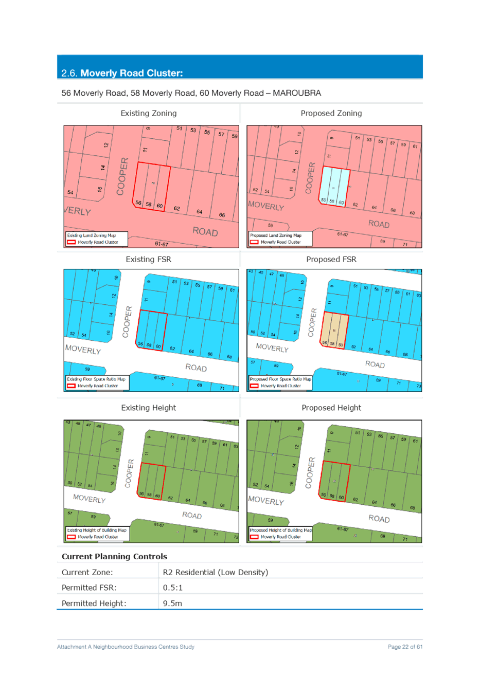
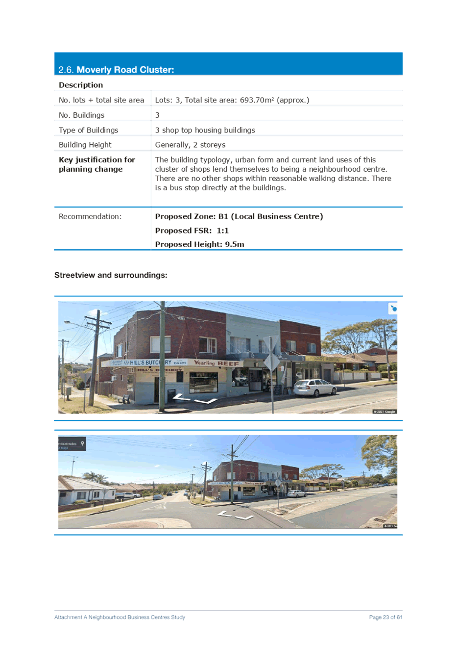
f. Moverly Road Cluster Rezone 56 Moverly Road, 58 Moverly Road, and 60 Moverly Road – MAROUBRA from R2 Low Density Residential to B1 Neighbourhood Centre with an applicable FSR of 1:1
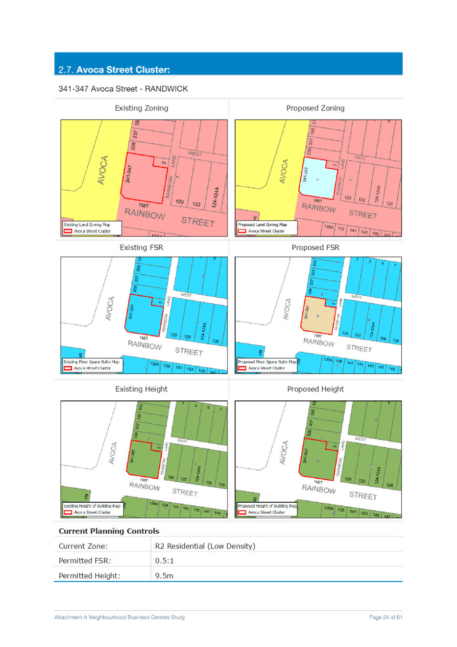
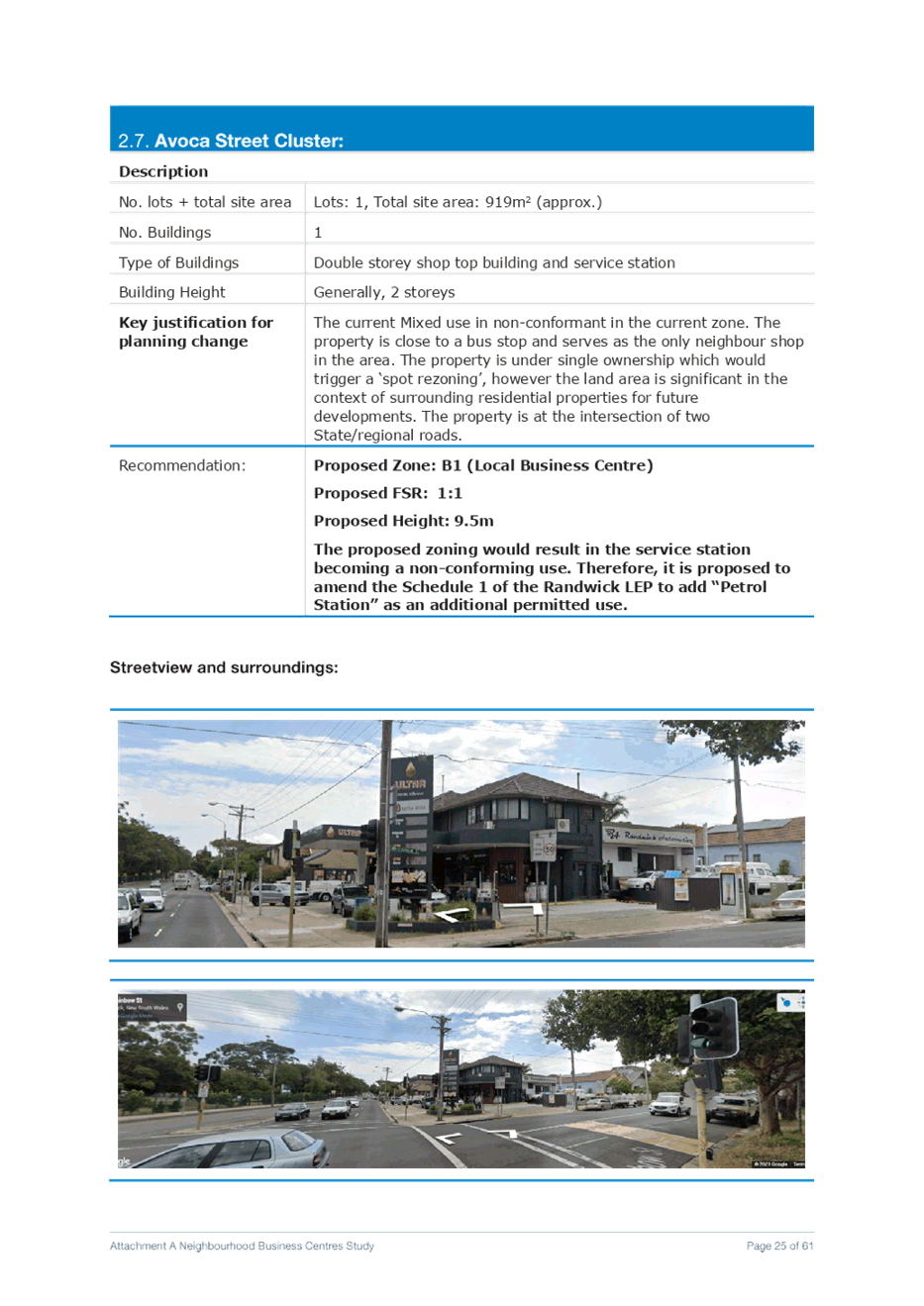
g. Avoca Street Cluster Rezone 341-347 Avoca Street - RANDWICK from R2 Low Density Residential to B1 Neighbourhood Centre with an applicable FSR of 1:1.
Amend the Schedule 1 of the Randwick LEP to add “Petrol Station” as an additional permitted use and amend the LEP maps as well.
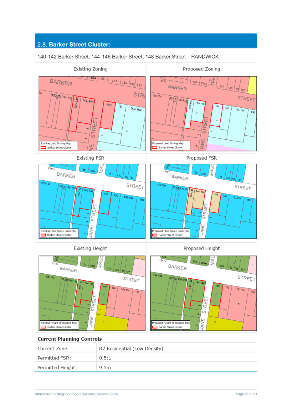
h. Barker Street Cluster Rezone 140-142 Barker Street, 144-146 Barker Street, and 148 Barker Street – RANDWICK from R2 Low Density Residential to B1 Neighbourhood Centre with an applicable FSR of 1:1.
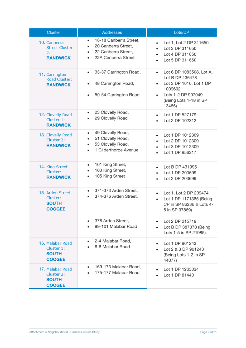
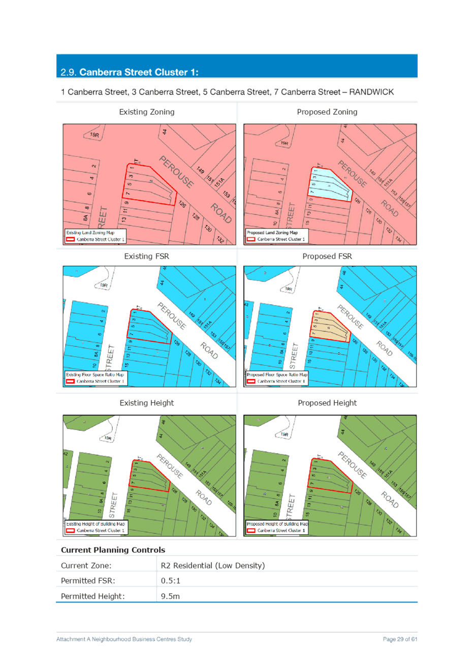
i. Canberra Street Cluster 1 Rezone 1 Canberra Street, 3 Canberra Street, 5 Canberra Street, 7 Canberra Street – RANDWICK from R2 Low Density Residential to B1 Neighbourhood Centre with an applicable FSR of 1:1
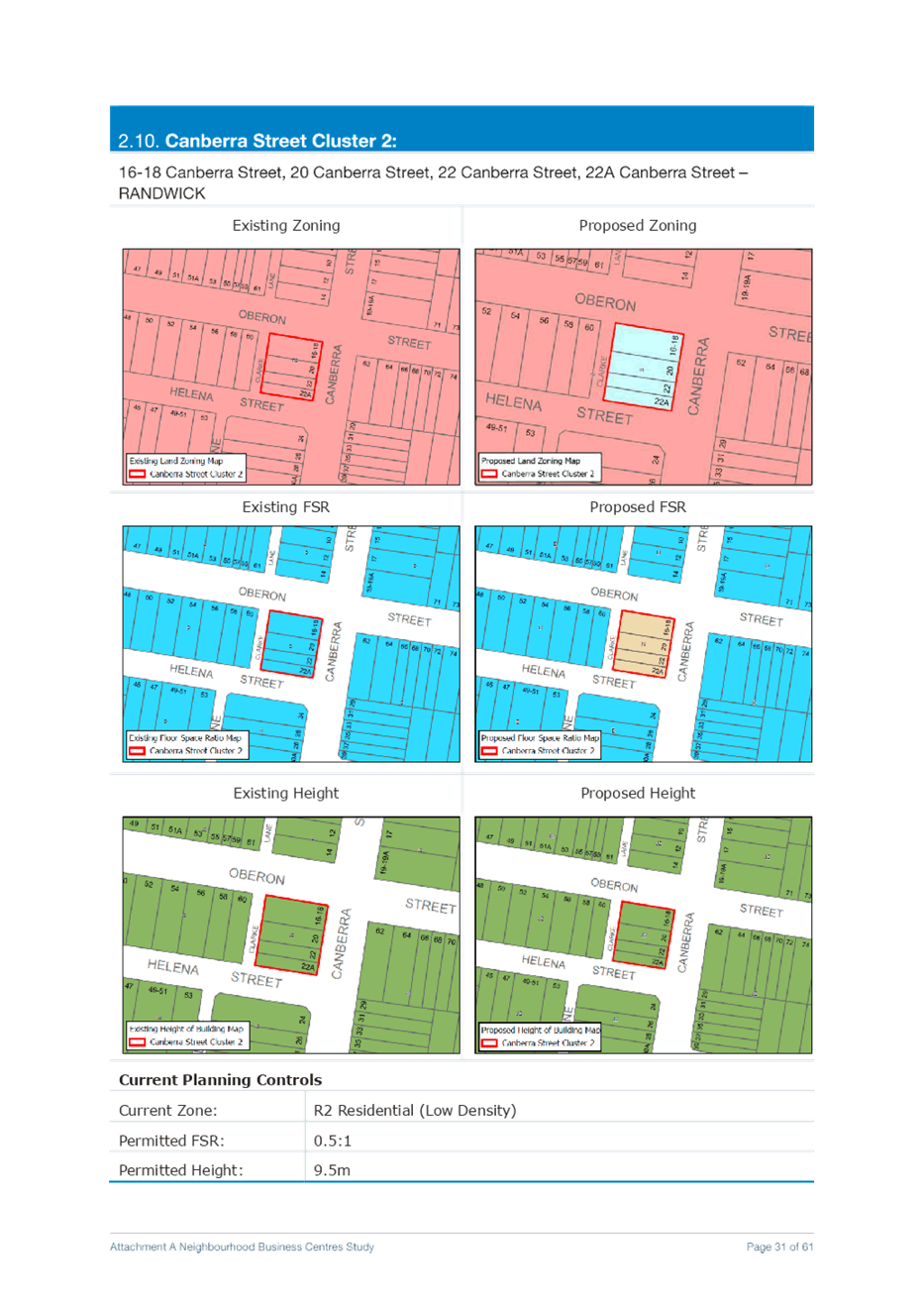
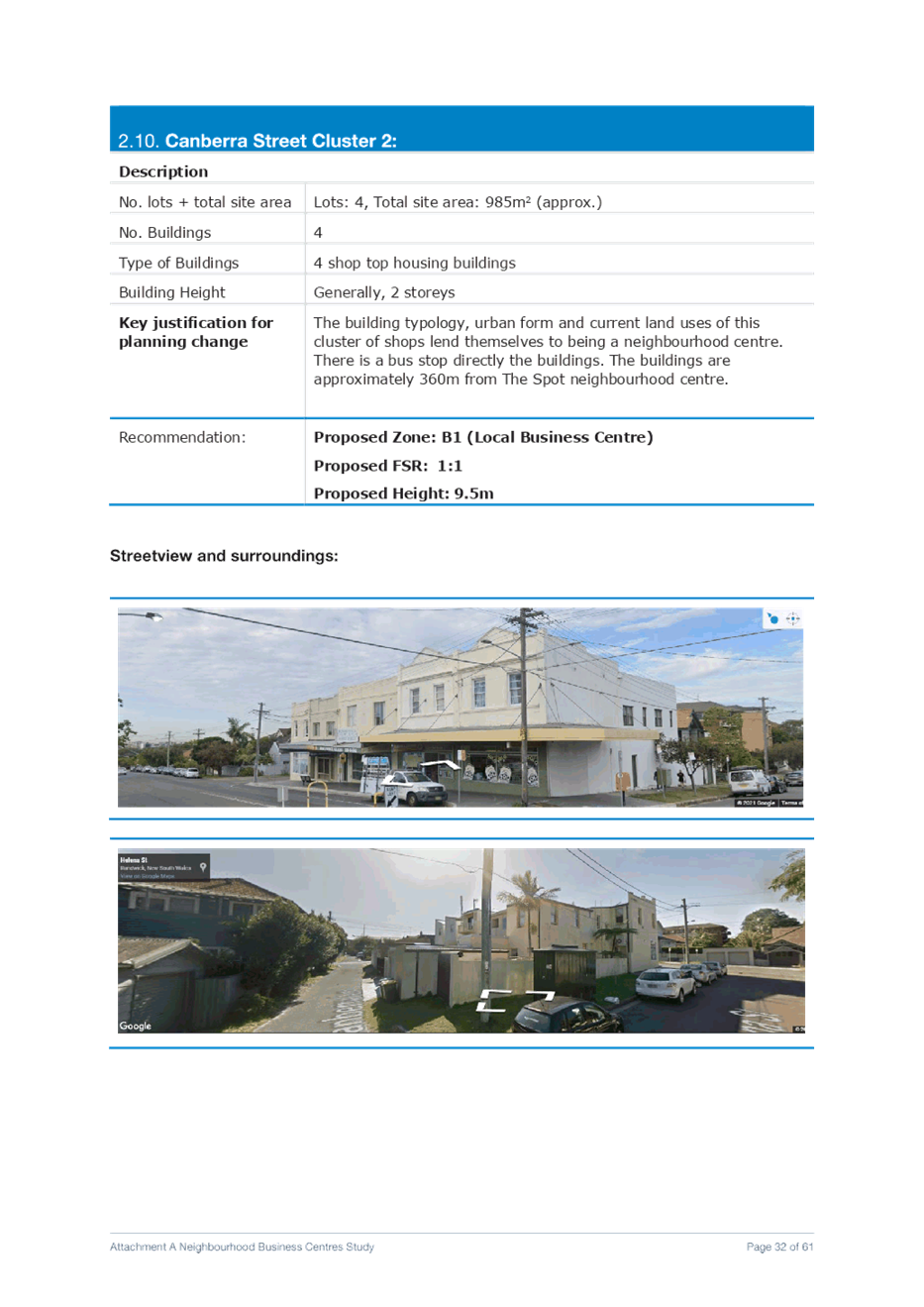
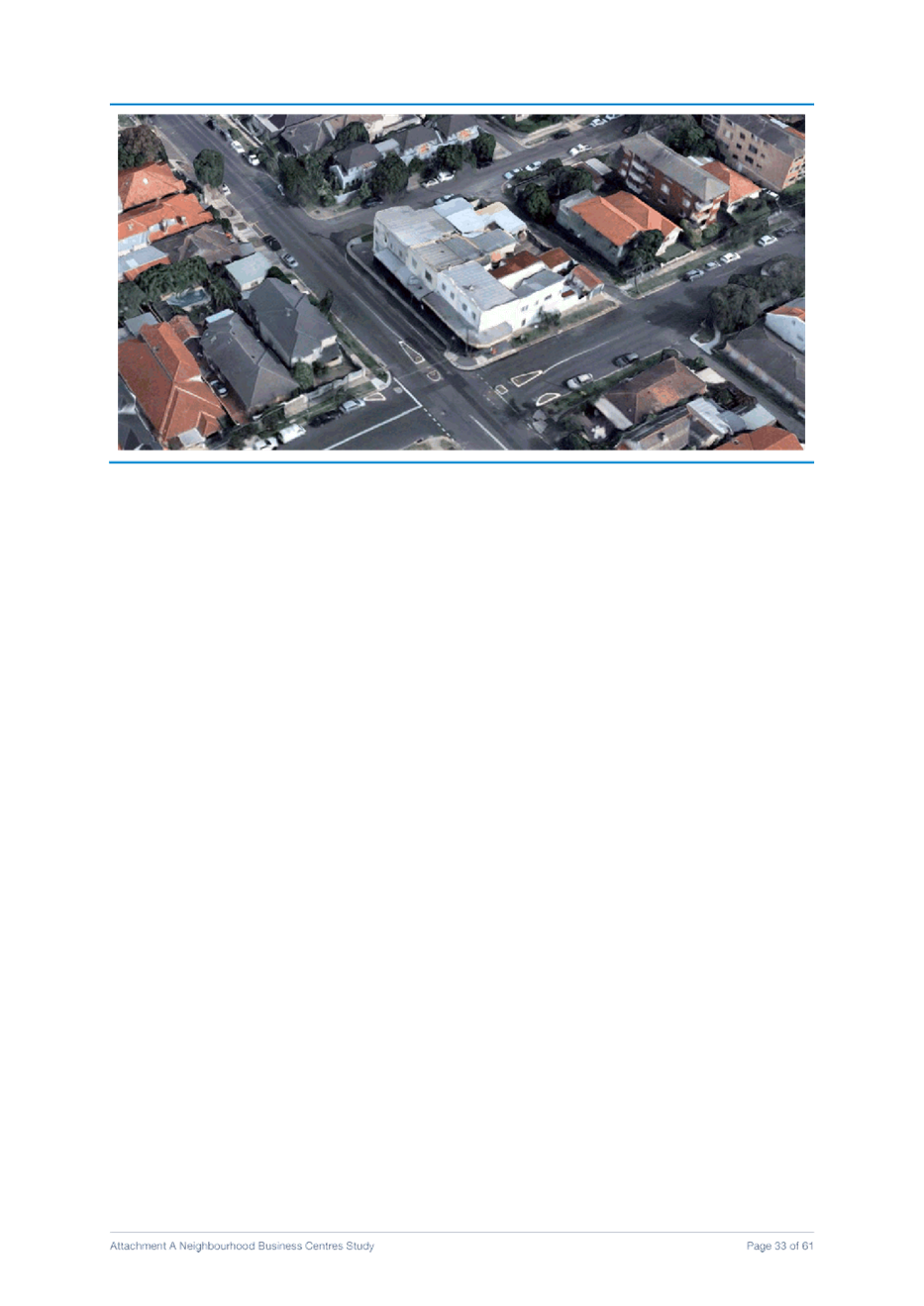
j. Canberra Street Cluster 2 Rezone 16-18 Canberra Street, 20 Canberra Street, 22 Canberra Street, and 22A Canberra Street – RANDWICK from R2 Low Density Residential to B1 Neighbourhood Centre with an applicable FSR of 1:1
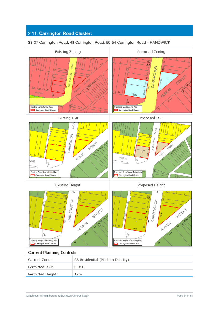
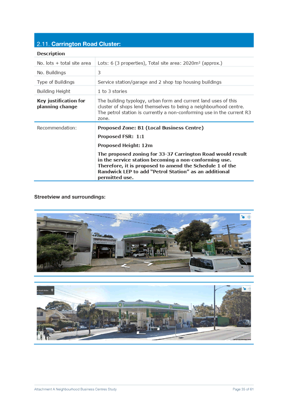
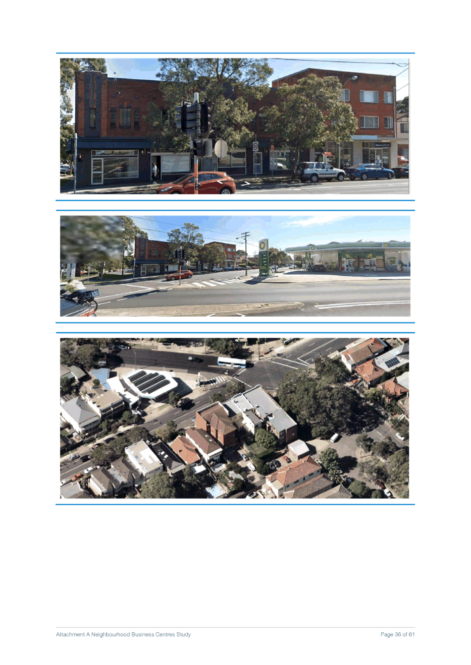
k. Carrington Road Cluster Rezone 33-37 Carrington Road, 48 Carrington Road, 50-54 Carrington Road – RANDWICK from R3 Medium Density Residential to B1 Neighbourhood Centre with an applicable FSR of 1:1.
Amend the Schedule 1 of the Randwick LEP to add “Petrol Station” as an additional permitted use for 33-37 Carrington Road and amend the LEP maps as well.
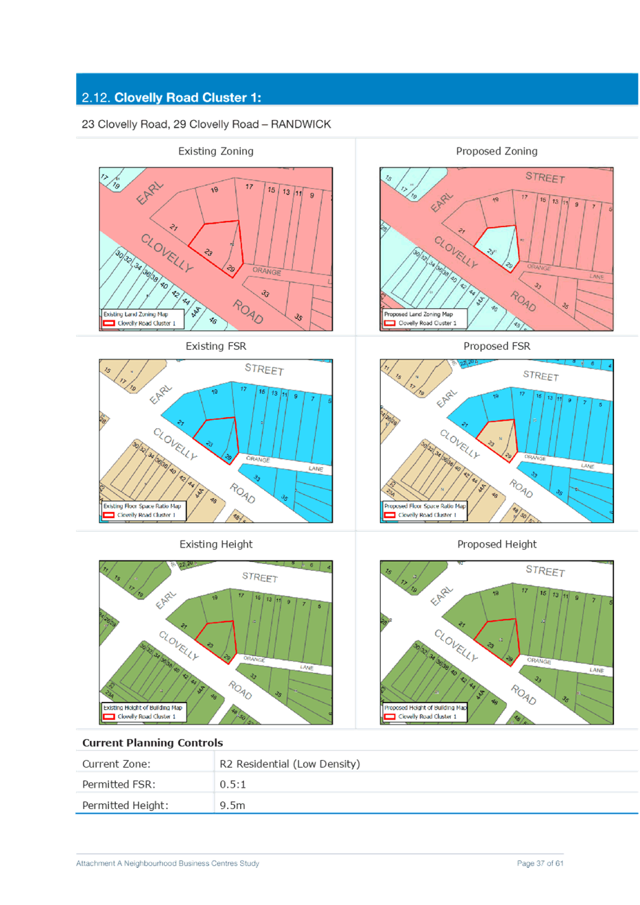
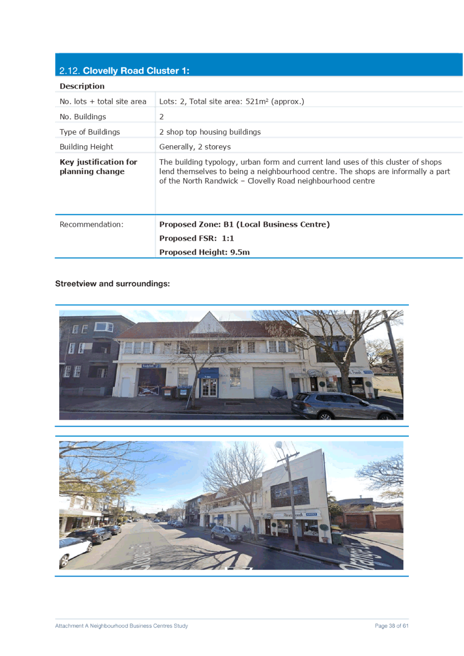
l. Clovelly Road Cluster 1 Rezone 23 Clovelly Road, 29 Clovelly Road – RANDWICK from R2 Low Density Residential to B1 Neighbourhood Centre with an applicable FSR of 1:1
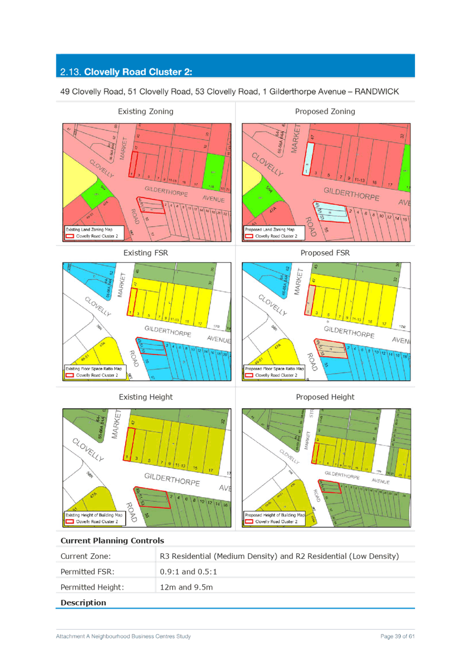
m. Clovelly Road Cluster 2 Rezone 49 Clovelly Road, 51 Clovelly Road, 53 Clovelly Road from R2 Low Density Residential to B1 Neighbourhood Centre with an applicable FSR of 1:1
Rezone 1 Gilderthorpe Avenue – RANDWICK from R3 Medium Density Residential to B1 Neighbourhood Centre with an applicable FSR of 1:1
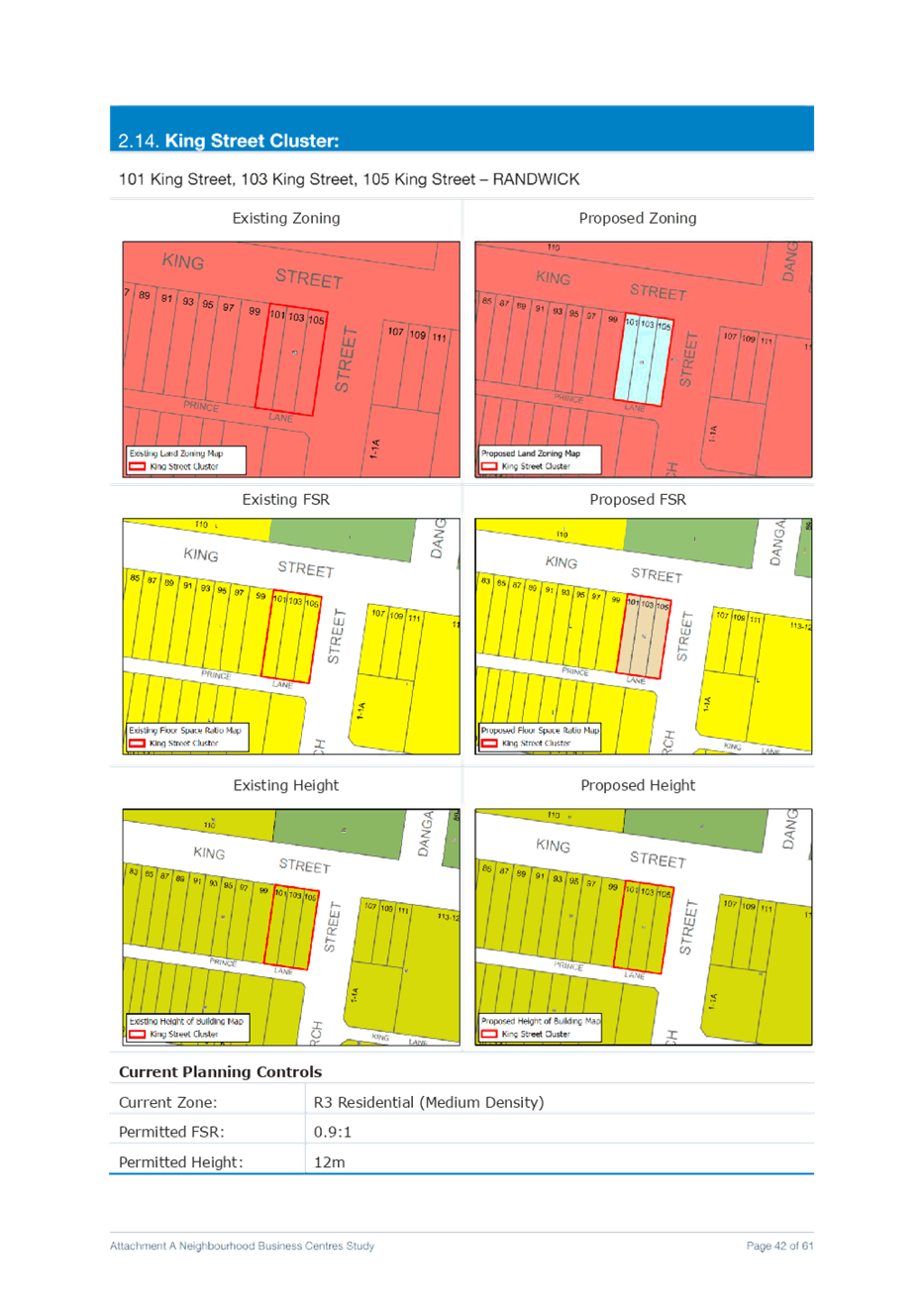
n. King Street Cluster Rezone 101 King Street, 103 King Street, and 105 King Street – RANDWICK from R3 Medium Density Residential to B1 Neighbourhood Centre with an applicable FSR of 1:1
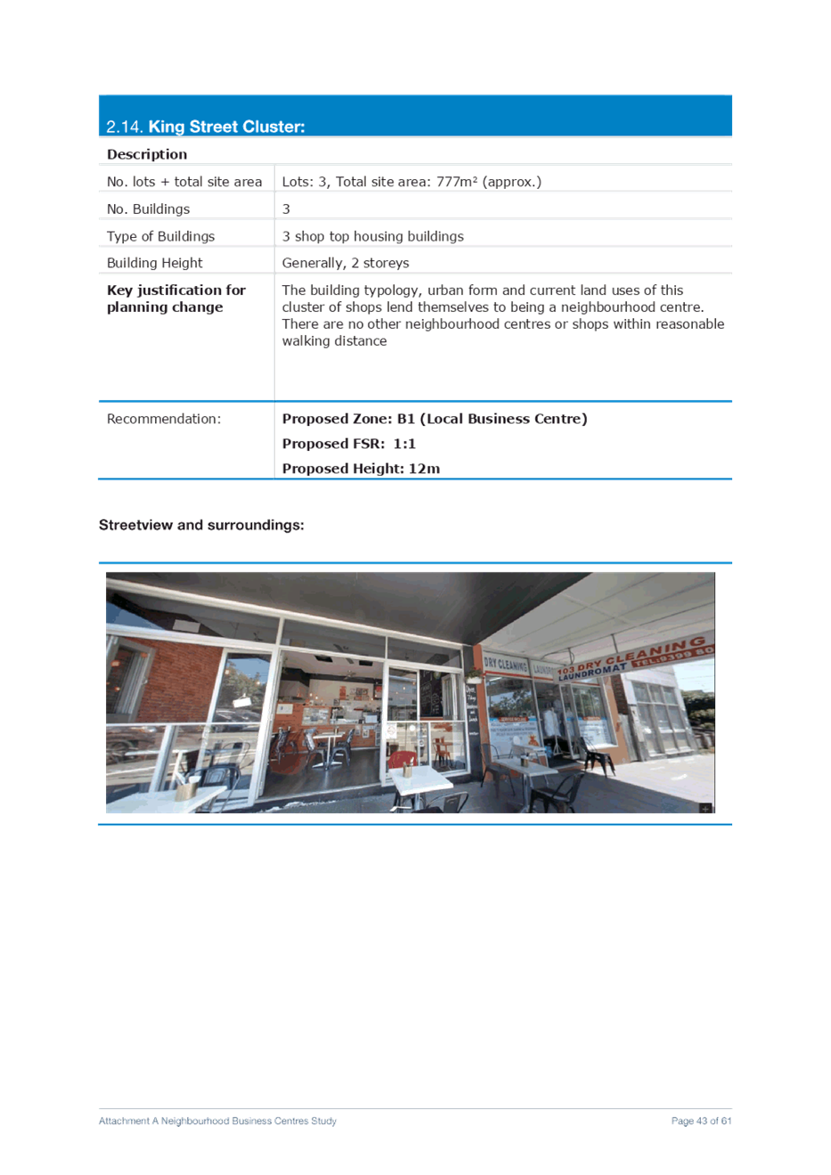
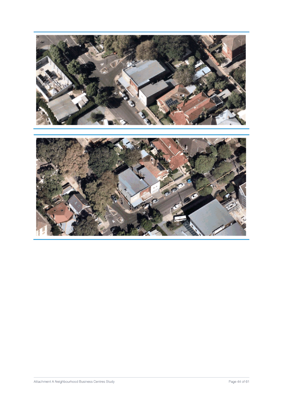
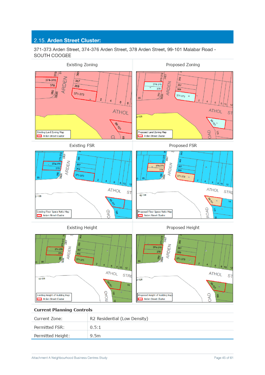
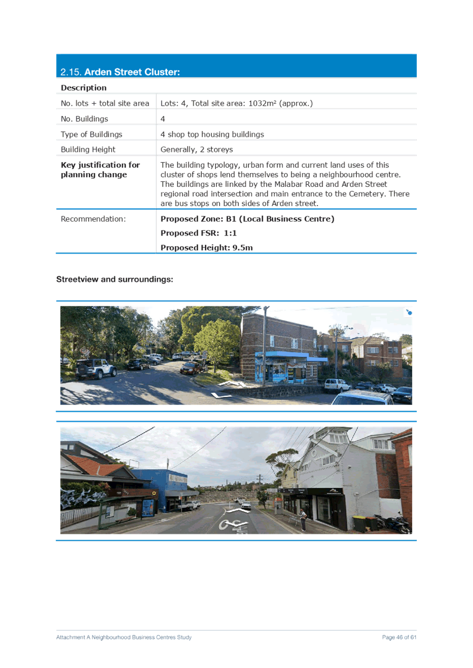
o. Arden Street Cluster Rezone 371-373 Arden Street, 374-376 Arden Street, 378 Arden Street, and 99-101 Malabar Road - SOUTH COOGEE from R2 Low Density Residential to B1 Neighbourhood Centre with an applicable FSR of 1:1
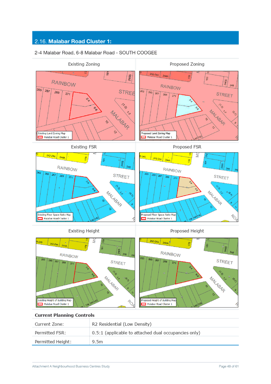
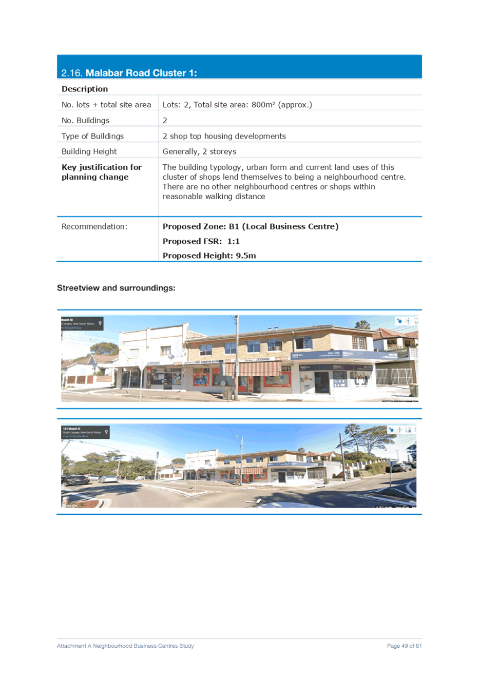
p. Malabar Road Cluster 1 Rezone 2-4 Malabar Road, and 6-8 Malabar Road - SOUTH COOGEE from R2 Low Density Residential to B1 Neighbourhood Centre with an applicable FSR of 1:1
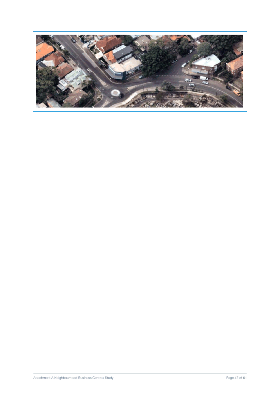
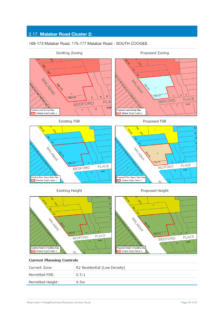
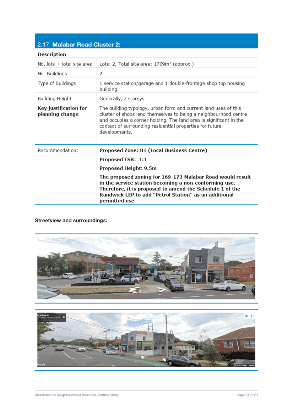
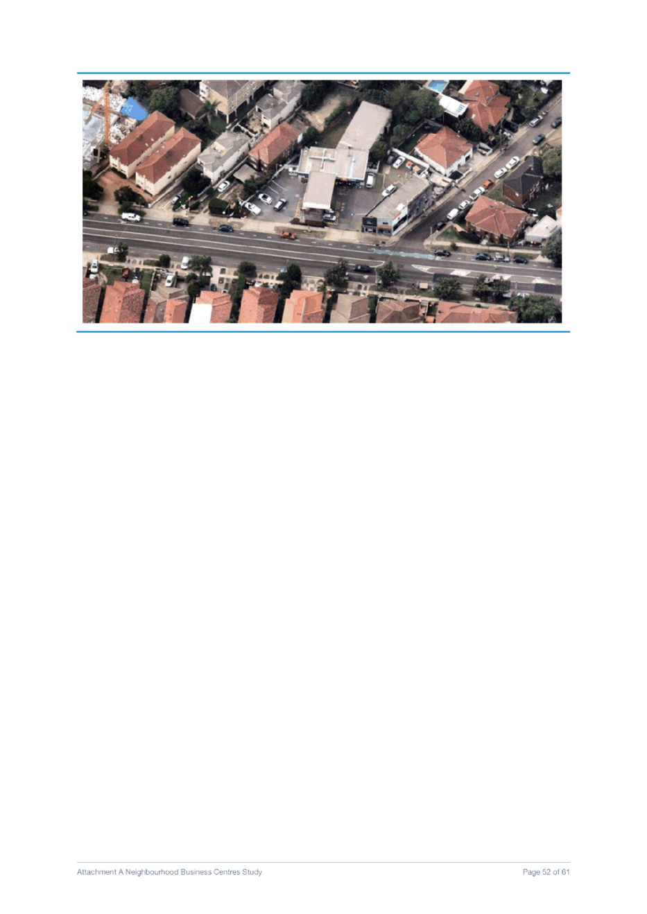
q. Malabar Road Cluster 2 Rezone 169-173 Malabar Road, 175-177 Malabar Road - SOUTH COOGEE from R2 Low Density Residential to B1 Neighbourhood Centre with an applicable FSR of 1:1
Amend the Schedule 1 of the Randwick LEP to add “Petrol Station” as an additional permitted use for 169-173 Malabar Road and amend the LEP maps as well.
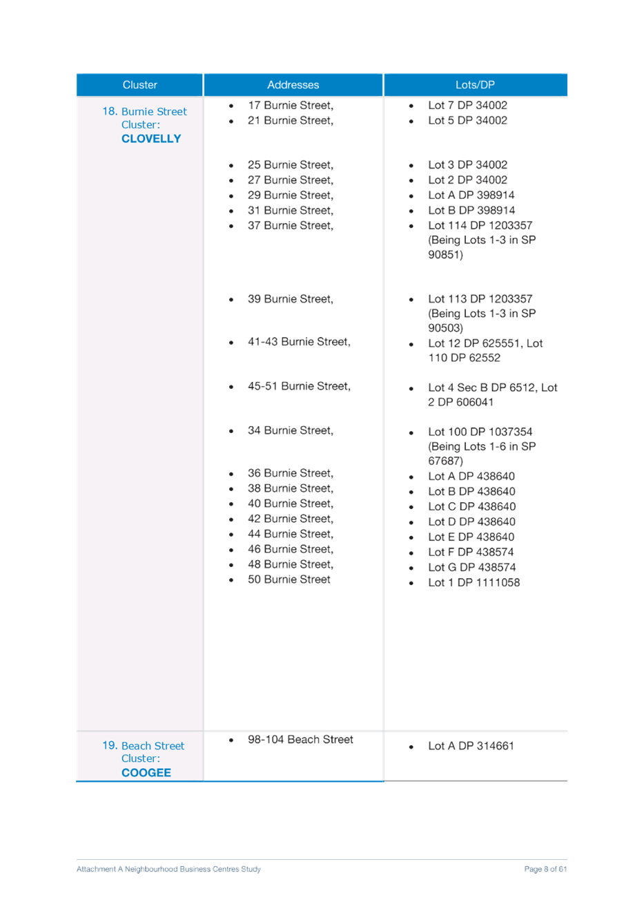
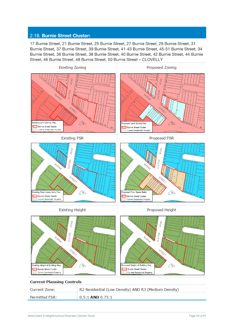
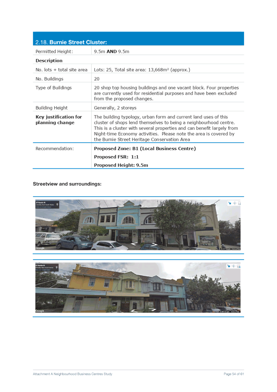
r. Burnie Street Cluster Rezone 17 Burnie Street, 21 Burnie Street, 25 Burnie Street, 27 Burnie Street, 29 Burnie Street, 31 Burnie Street, 37 Burnie Street, 39 Burnie Street, 41-43 Burnie Street, 45-51 Burnie Street – CLOVELLY, from R2 Low Density Residential to B1 Neighbourhood Centre with an applicable FSR of 1:1
Rezone 34 Burnie Street, 36 Burnie Street, 38 Burnie Street, 40 Burnie Street, 42 Burnie Street, 44 Burnie Street, 46 Burnie Street, 48 Burnie Street, 50 Burnie Street – CLOVELLY from R3 Medium Density Residential to B1 Neighbourhood Centre with an applicable FSR of 1:1
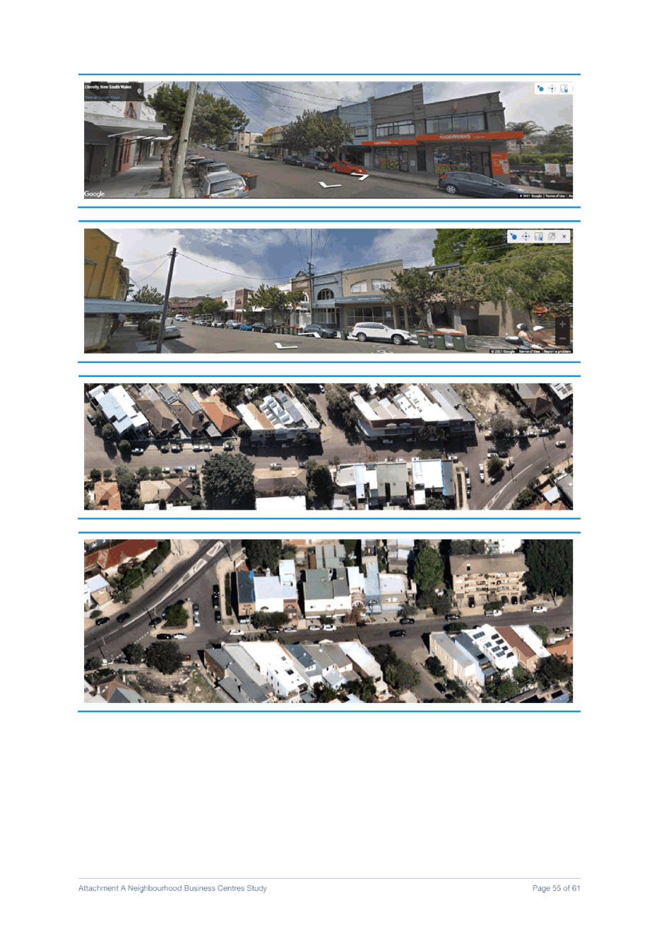
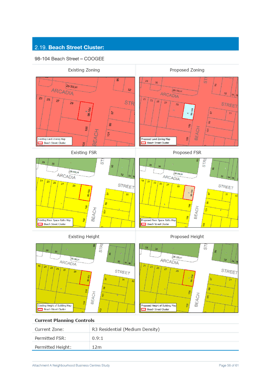
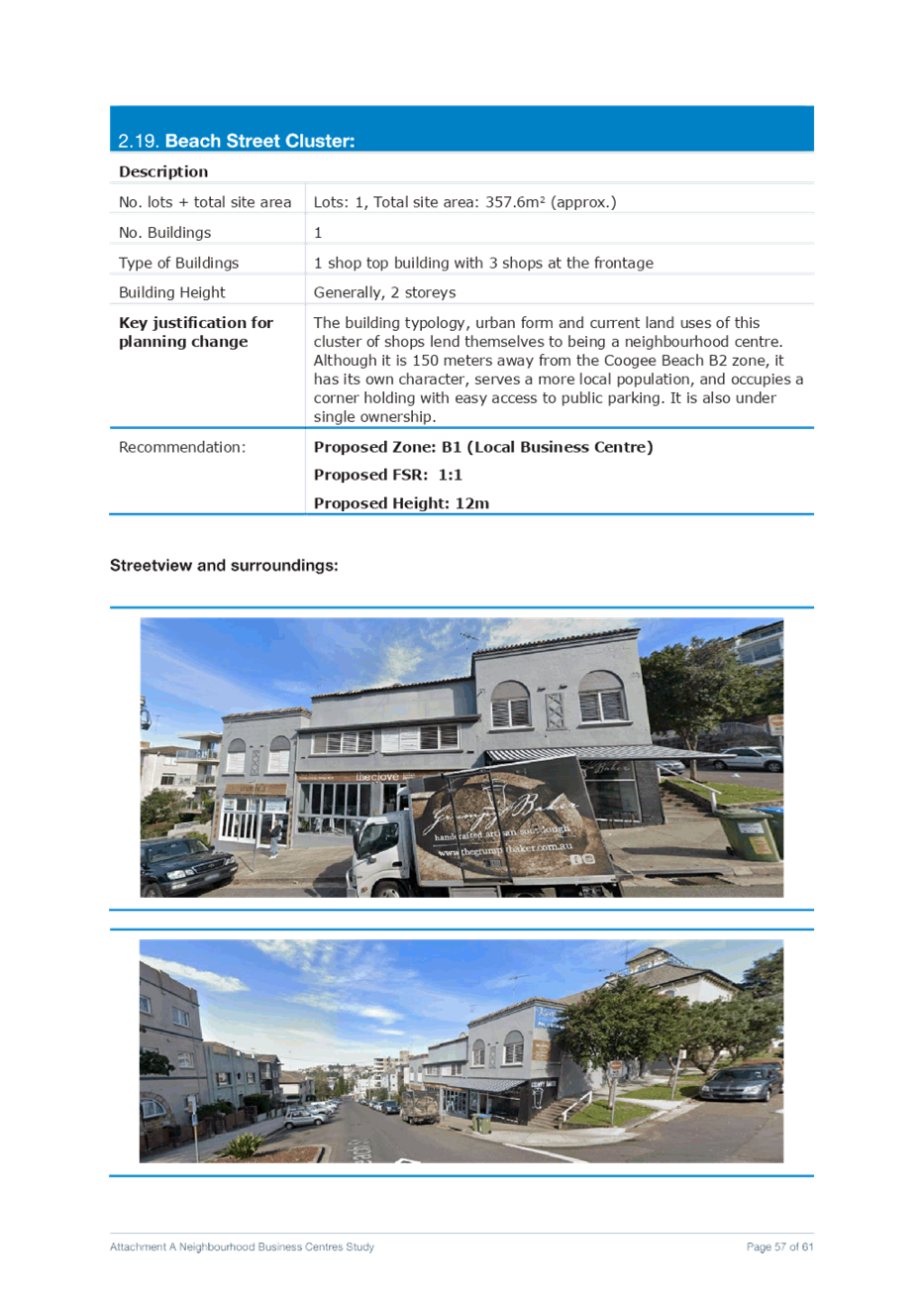
s. Beach Street Cluster Rezone 98-104 Beach Street – COOGEE from R3 Medium Density Residential to B1 Neighbourhood Centre with an applicable FSR of 1:1
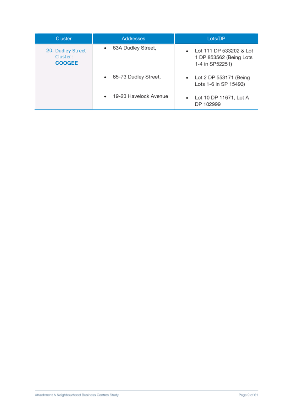
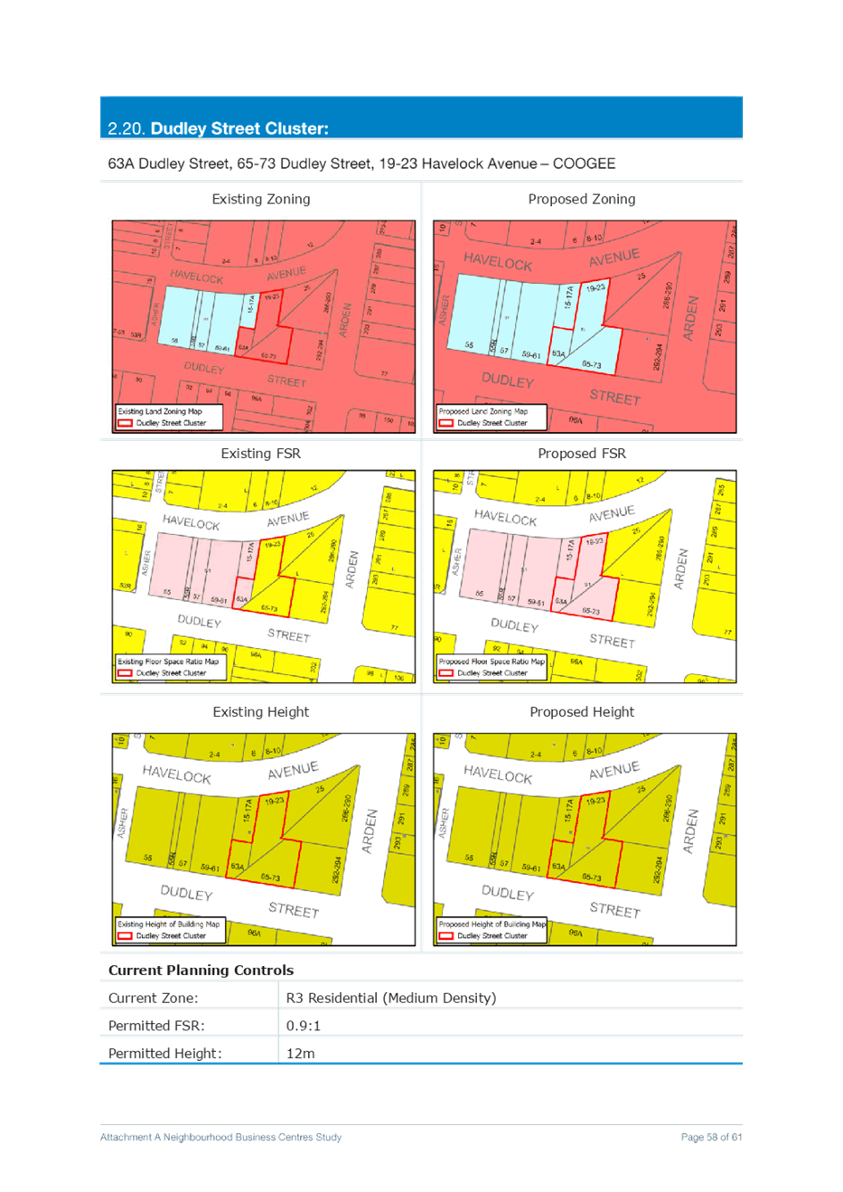
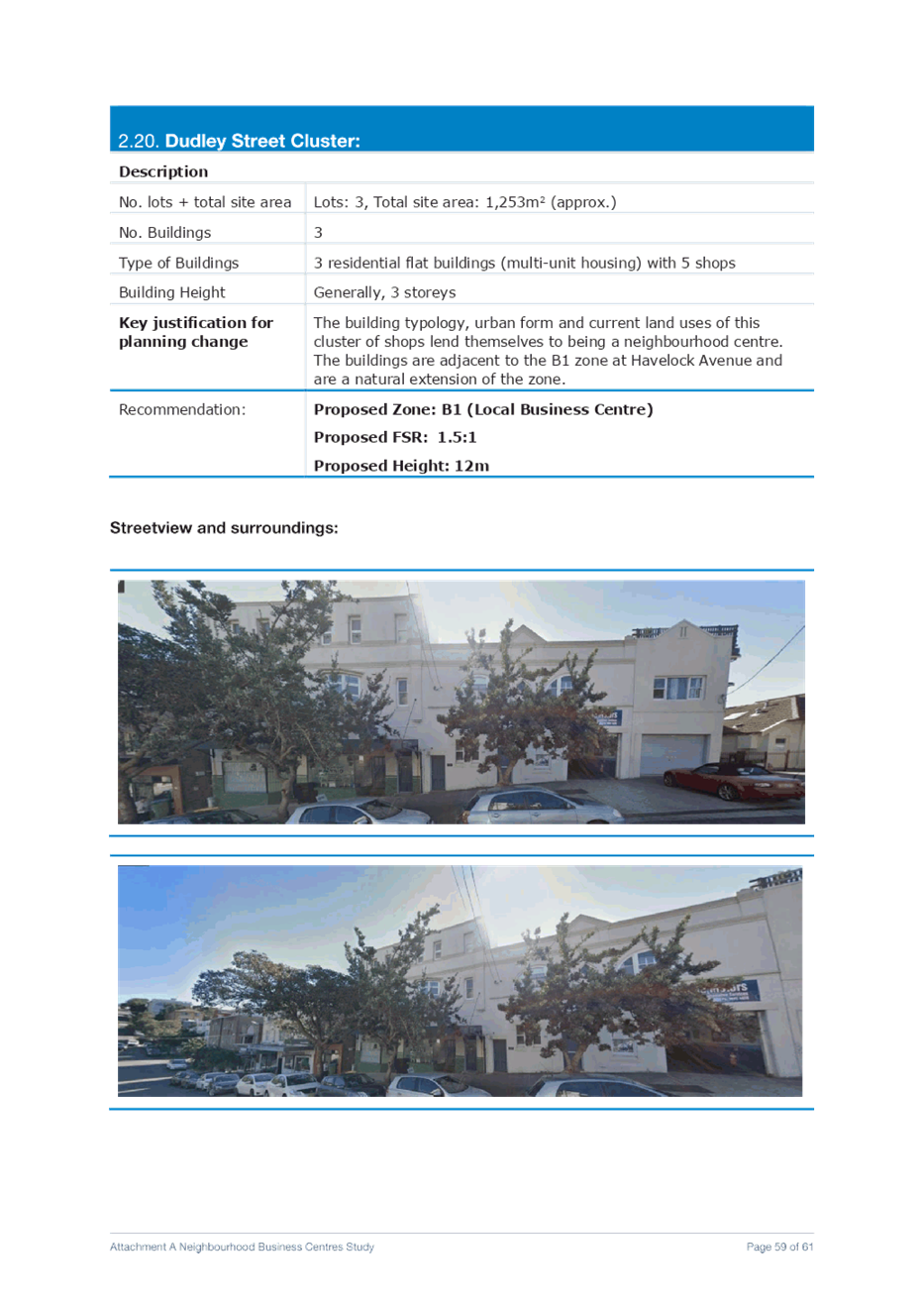
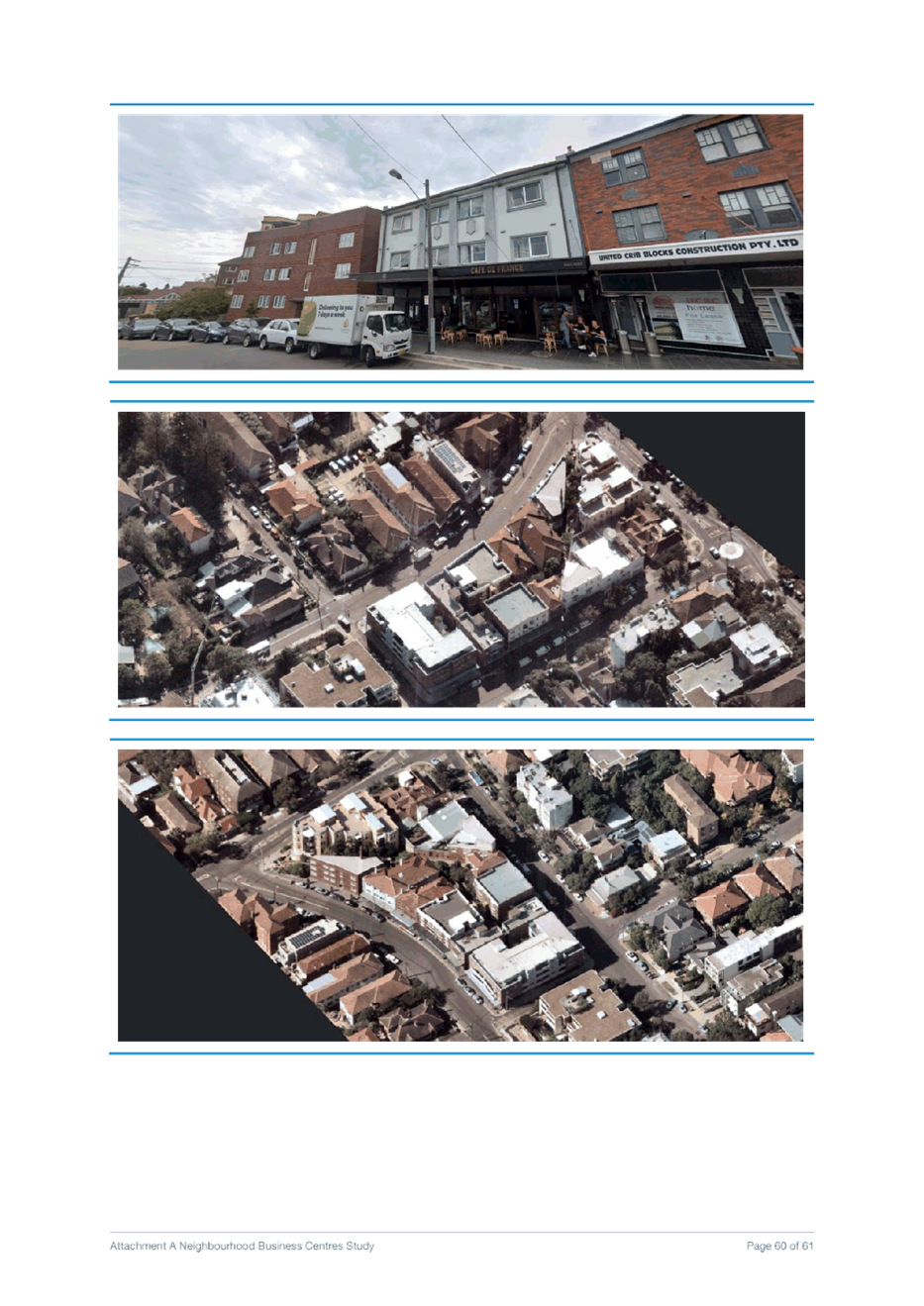
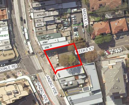
t. Dudley Street Cluster Rezone 63A Dudley Street, 65-73 Dudley Street, and 19-23 Havelock Avenue – COOGEE from R2 Low Density Residential to B1 Neighbourhood Centre with an applicable FSR of 1.5:1
Proposed Amendments to the RLEP 2012- Randwick Hospitals Expansion It is proposed to amend the RLEP 2012 in relation to the Hospital campus expansion area to match controls that currently apply to the Hospital campus as follows:
· Rezone the block from R2 Low Density Residential and R3 Medium Density Residential to SP2 Health Services Facility (refer to figures 22 and 23);
· Remove the existing residential (9.5m and 15m) Height of Building (HOB) controls for the Randwick Hospital Campus Expansion Area. Remove part of the current Randwick Hospital western perimeter height control (Refer Figures 24 and 25);
· Remove the applicable FSR in line with the protocol for all special purpose and infrastructure zones. Refer Figure 26 and 27.
g) Not support the ATC request that Council consider an amendment to Schedule 1 of the RLEP 2012 (“Additional permitted uses”) and accompanying map to permit entertainment facilities, food and drink premises and commercial premises with development consent in the ‘Spectator Precinct’ of Royal Randwick Racecourse (RRR). Further consideration is required of the implications of the rezoning proposal and its impacts on the broader Randwick Strategic Centre as part of a separate planning proposal.
h) Amend RLEP 2012 to rezone the existing Light Rail Stabling Yard from RE1 Public Recreation to SP2 Infrastructure in the area indicated on the zoning maps (Figures 33 and 34).
|
|
1.⇩ |
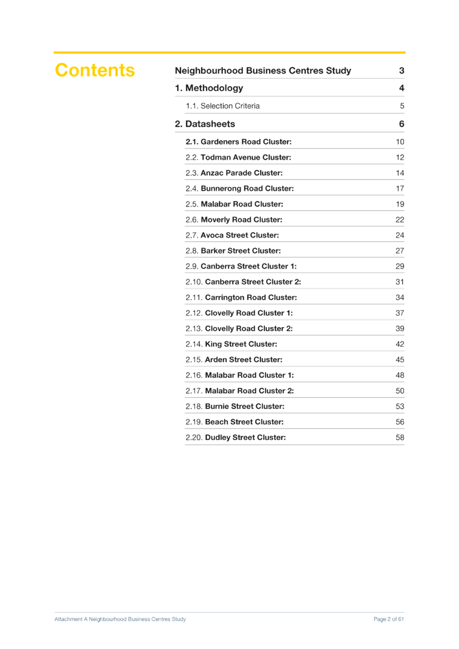
Attachment A - Neighbourhood Business Centres Study Datasheets |
|
Purpose
This report is seeking advice from the Randwick Local Planning Panel (RLPP) on the merits of proposed changes to the Randwick LEP 2012 to implement the priorities and actions of the Eastern District Plan, the Randwick Local Strategic Planning Statement (LSPS) and the Collaboration Area Randwick Place Strategy in relation to economic development.
The approach comprises 4 pieces of analysis that will inform the economic development planning proposal and the new LEP:
1. Night time economy
2. Short term rental accommodation
3. Neighbourhood Centres
4. Collaboration Area – Randwick Place Strategy (Randwick Hospital Campus Expansion and the Royal Randwick Racecourse Light Rail Stabling Facility)
This report is one in a series of reports which will be combined into the Comprehensive LEP Planning Proposal. Other reports cover heritage, environmental provisions, local character, rezoning requests and the Randwick Junction Town Centre Planning Strategy.
The recommendations from this and other reports will be integrated into a single comprehensive planning proposal which is anticipated to be reported to Council in May 2021.
Discussion
Background
In February 2020, Council endorsed the Randwick City Local Strategic Planning Statement (LSPS) as required under the Environmental Planning and Assessment Act 1979 (the EP&A Act) and the Eastern City District Plan. These documents provide the framework for land use planning and decision-making in Randwick City over the next 20 years.
A comprehensive community consultation program undertaken by Council in March and April 2019 branded Vision 2040: Shaping Randwick’s Future provided significant community input to shape the LSPS.
Following finalisation of the LSPS, Council is required to review the Randwick Local Environmental Plan 2012 (LEP) to give effect to the principles and actions of the LSPS. This planning proposal seeks to implement several proposed economic development planning priorities that are detailed in the LSPS.
Policy context
Greater Sydney Region Plan – A Metropolis of Three Cities
The Greater Sydney Region Plan, A Metropolis of Three Cities integrates land use, transport, infrastructure and planning across Greater Sydney to achieve its vision of three cities where most residents live within 30 minutes of their jobs, education, health facilities, services and great places. This Plan sets a 40 year vision (to 2056) and establishes a 20 year plan to manage growth and change for Greater Sydney in the context of social, economic and environmental matters.
Eastern City District Plan
The Eastern City District Plan is the Greater Sydney Commission’s (GSC) 20-year plan to manage growth and change in the Eastern City District of Sydney to achieve the 40-year vision for Greater Sydney. It contains the planning priorities and actions for implementing A Metropolis of Three Cities at a district level and aims to be a bridge between regional and local planning. The following priorities and actions have guided the planning for economic planning in Randwick City outlined in this report:
· Planning Priority E1 Planning for a City supported by infrastructure
· Planning Priority E2 Working through collaboration
· Liveability Priority E3 Providing services and social infrastructure to meet peoples changing needs.
· Liveability Priority E4 Fostering healthy, creative, culturally rich and socially connected communities
· Liveability Priority E5 Providing housing supply, choice and affordability with access to jobs, services and public transport
· Liveability Priority E6 Creating and renewing great places and local centres, and respecting the District’s heritage
· Productivity Priority E8 Growing and investing in health and education precincts and the innovation corridor
· Productivity Priority E10 Delivering integrated land use and transport planning and a 30-minute city
· Productivity E11 Growing investment, business opportunities and jobs in strategic centres
Randwick Local Strategic Planning Statement (LSPS)
The Randwick LSPS was informed by the Vision 2040: Shaping Randwick’s Future community consultation program. The Randwick LSPS outlines our community’s vision for the future of Randwick City, underpinned with planning priorities about where housing, jobs, infrastructure and open space should be located.
There are 22 planning priorities outlined in the LSPS under the 4 overarching themes of Liveability, Productivity, Sustainability and Infrastructure and Collaboration.
The amendments outlined in this report respond to the following LSPS Planning Priorities:
· Action 1.2: Work with the Department of Planning, Industry and Environment to seek an exclusion for Randwick City LGA from the provisions of the Affordable Rental Housing SEPP and develop a local response to the provision of boarding houses
· Action 6.4 Review land use classification of Special Purpose zoned land to identify opportunities for new and/or shared use of facilities
· Action 8.2 Integrate land use, infrastructure and transport projects to deliver the 30-minute city
· Action 9.1 Deliver key priorities from the Randwick Collaboration Area Place Strategy and Structure Plan
· Action 9.2 Review the land use zoning and planning controls of the Randwick Health and Education Strategic Centre
· Action 10.1: Finalise the Economic Development Study and prepare an updated Randwick City Economic Development Strategy to:
o plan for capacity for future retail and commercial redevelopment in town and local centres
o make strategic recommendations on the future economic profile of Randwick City’s network of local centres
o ensure our town and neighbourhood centres remain vibrant and build on their character and sense of place
· Action 10.2: Prepare a Local Centre Study to identify the current and future role of our centres, and opportunities to respond to the growing housing and employment demand
· Action 11.1: Prepare an Economic Development Strategy incorporating the outcomes of the Night-Time Economy Study, to:
o Include overarching objectives on supporting a diverse night-time economy in the LEP and DCP
o Introduce Exempt Development provisions to allow retail to stay open until 11pm without requiring development consent
o Introduce Exempt Development provisions to allow small scale cultural activities to occur in retail and low impact businesses without requiring development consent
· Action 12.1 Undertake a Visitor Management Study as part of an Economic Development Strategy to identify opportunities to implement place-based initiatives and improve visitor experiences including:
o provision of well-designed and located supporting facilities; enhanced amenity, vibrancy and safety of places
o provision of places for artistic and cultural activities
o protection of heritage and biodiversity to enhance cultural and eco-tourism
o growth of the night-time economy
o improved public transport to serve the transport access needs of tourists
o a coordinated approach to tourism activities, events and accommodation
· Action 23.1 Work with the key stakeholders of the Randwick Collaboration Area to deliver the Randwick Collaboration Area Place Strategy
Randwick LGA Economic Analysis Report 2019
The Randwick LGA Economic Analysis Report 2019 by SGS identifies there is increased demand for retail floorspace for all neighbourhood and local centres across Randwick City over the next 20 years. The additional demand is for approximately 39,128m2 of additional retail floorspace across the LGA to 2036. In relation to commercial floorspace, the report indicates that demand is projected to grow by 51,962 m2 in 2036.
The report notes that most of the additional demand will be for growth in supermarket, hospitality and services industries. Other growth areas include retail, professional and business services. The main centres that are likely to experience a demand for growth in employment/retail floor space is projected to be in Kingsford, Kensington, Maroubra Junction and Randwick Junction town centres. The report recommends a mix of business and retails uses in smaller centres as the best approach to underpinning population growth to meet expected demand. SGS is currently preparing an addendum to this Study for Council to consider impacts of COVID on the economy and implications for future planning for employment/retail floor space across the City.
This planning proposal responds to projected employment floor space demand by rezoning existing clusters of shops that are currently zoned residential to the B1 Neighbourhood Centre zone as a measure to retain existing employment floor space to serve the needs of local neighbourhoods and improve walkability and sustainability.
Planning Proposal
Purpose/objectives
The objective of this planning proposal is to amend the RLEP 2012 to:
· Strengthen Randwick City’s cultural life and create a more diverse and inclusive night-time economy;
· Make it easier for shops and low impact businesses to trade in business zones from 7am to 11pm, 7 days a week;
· Make it easier for small scale cultural activities to take place in existing office, retail and community facilities;
· Permit galleries, maker spaces, studios and the like in existing purpose built commercial buildings within the residential zones;
· Protect the existing stock of employment/retail lands in residential areas;
· Provide a range of employment opportunities and to contribute to economic growth;
· Minimise the impacts of short term rental accommodation (STRA) on the supply of rental housing, residential amenity and local character in Randwick City;
· Provide for the expansion of high-quality hospital services, including innovative health, research and development functions;
· Provide health services with access to high quality public transport (Light Rail); and
· Recognise the provision of Light Rail stabling infrastructure as part of the public transport network in Randwick City.
Explanation of Proposed LEP Provisions
1. Night Time Economy
LSPS Action 11.1: Prepare an Economic Development Strategy incorporating the outcomes of the Night Time Economy Study including:
· Overarching objectives on supporting a diverse night time economy in the LEP and DCP;
· Exempt Development provisions to allow retail to stay open until 11pm without requiring development consent; and
· Exempt Development provisions to allow small scale cultural activities to occur in retail and low impact businesses without requiring development consent.
Background: Night Time Economy Study 2019
The Randwick Night Time Economy Study 2019 (the Study) was prepared in response to a Council resolution (Notice of Motion 18/2018) which called for practical initiatives to enhance Randwick City’s night time economy to foster economic development, support the live music and creative sectors, and deliver a diverse offering of night time activities to a wider demography.
The Study (and subsequent recommendations in this report) have been underpinned by substantial input from the Randwick City Night Time Economy Advisory Committee comprising industry experts from the live music, performing arts, retailing, urban design and small bar sectors. The Committee has been instrumental in identifying barriers and challenges for industry stakeholders, as well as opportunities for reducing planning and regulatory red tape.
The Study has found that Randwick City has the potential to reap substantial socio- economic benefits from cultivating a well-managed and diverse night-time economy. Research of Australia’s night time economy has shown that it generates significant economic output and if well managed and supported will continue to grow and diversify. In 2017 the Australian night time economy accounted for 17% of all establishments (374,835 out of 2,200,000), collectively employing a total of 3.1 million people. The industry makes up 26% of Australian employment and accounts for 19% of total turnover, generating almost $715 billion in revenue in 2017. At the state level, NSW is the largest contributor to Australia’s core night time economy, accounting for 34% of establishments and 30% of night time economy employment and turnover.
At the local level, growth and diversification of the night time economy would have a positive impact for local businesses through increased patronage over longer and different time periods. It would help stimulate job creation, particularly flexible employment, support the cultural and creative sectors, while boosting local tourism, retail and none-core activities such as transport and security. These benefits are particularly critical given the current COVID pandemic, and stimulation of the night time economy via the land use planning framework would be an essential measure to supporting the economic recovery post pandemic.
In terms of community benefits, a mix of businesses and social and cultural attractions would help increase wider participation, attracting a diversity of ages and lifestyles, facilitating more connected, inclusive and resilient communities. Having a broad range of people participating in the night time economy would also have a positive impact on the perception of safety at night and potentially assist in reducing crime. The night time economy can also play an important role in urban renewal and revitalisation, helping to create a sense of place and identity, and contributing to thriving vibrant town centres. This is particularly pertinent for urban renewal areas such as Kensington and Kingsford town centres and the Randwick Collaboration Area which would benefit from a thriving night time economy that builds reputation, reinforces local character and inspires new uses of public space.
Proposed Changes to the RLEP 2012 – Night Time Economy
Extensive audit work and community and industry consultation has identified that Randwick City presently has a limited night time economy that is centred upon dining and drinking with the perception that there is nothing else to do after work. These findings have informed key directions on diversifying the night time economy to attract a broader demographic of people of all ages and interests through supporting a range of low impact businesses and cultural activities that do not encourage excessive noise or encourage anti-social behavior.
The Study has identified that key measures for diversifying the night time economy include:
· Overarching objectives for the business zones to make it clear that the intent of business centres is to support both day and night time activity;
· Allowing low impact unlicensed uses including shops, business premises and kiosks to stay open later in the business zones (subject to criteria being met), recognising that extended trading hours in the right locations would cater for shift workers, attract a greater diversity of people to frequent local businesses, and improve perceptions of safety through increased street activity. It would offer low impact businesses the flexibility of choosing their operating hours within a limited threshold to take advantage of seasonal variations, festivals, and events and provide opportunities for people to shop and attend appointments after work;
· Supporting small scale low impact cultural activities to take place in office, retail, business and community facility premises (e.g. temporary art exhibitions, short film, performance or talks). These type of intimate events would enhance the community’s access to the arts, culture and film sectors locally, contribute to the cultural fine grain of our City and utilise available floor space that is currently an untapped resource; and
· Allowing galleries, studios and the like (with development consent) in existing purpose built commercial buildings and shops that are located in residential zones.
Key recommendations for diversifying the night time economy via amendments to RLEP 2012 are summarised as follows:
Objectives for Business Zones
Randwick City’s planning and policy framework does not contain specific objectives relating to the night time economy. Objectives are important in articulating Council’s aspirations for an area and for setting out the strategic land use direction for a specific use or activity.
It is proposed that a new objective be included for the B1 Neighbourhood Centre and B2 Local Business Zones on supporting a diverse, safe and inclusive day and night-time economy.
The proposed objective would reinforce and acknowledge the purpose of the business zones which is to support businesses and activities that occur during day and/or night. Zone objectives would help guide future development and decision making around night time activities which are an important part of the function and nature of our town centres.
Hours of Operation- Low Impact Shops and Businesses
Randwick City’s town and neighbourhood centres permit a wide range of uses, and most businesses and retailers do not have a negative impact on the local area such as excessive noise or anti-social behaviour. Operating hours for businesses are regulated through conditions of development consent via the Development Application (DA) approval process.
The majority of businesses in Randwick City typically apply for 8am to 6pm opening hours, which can limit flexibility of operation, should there be future opportunities for trading at night. If a business
wishes to extend their opening hours to take advantage of seasonal fluctuations for instance, a new development consent is required which can be cost prohibitive and time consuming to obtain, particularly if it is for a one off occasion. Proposals for night time trading in Randwick City are assessed under the planning controls of the Randwick DCP 2013 (Section D13- Late Night Trading).
As a measure to diversify the night time economy, cater to the needs of the broader community (including shift/key workers) and activate town and neighbourhood streetscapes, it is proposed to introduce new Exempt Development provisions to permit approved shops and low impact unlicensed business premises to trade from 7am to 11pm without requiring development consent. Proposals would need to satisfy requirements including the following proposed standards:
· The shop, business premises or kiosk must be located on land zoned as B1 Neighbourhood Centre or B2 Local Centre;
· Not be a licensed premise in accordance with the definition under the Liquor Act 2007; and
· Not contravene any existing condition of an active development consent that applies to the premises relating to noise, parking, loading or waste management as a result of the Exempt Development provision.
It should be noted that Council is currently running a trial on later trading hours for town and neighbourhood centres across the City in the B1 Neighbourhood Centre and B2 Local Centre zones. The proposed Exempt Development provisions would operate separately to these trial hours and apply only to low impact uses such as shops and businesses premises (eg pharmacies, bookshops, personal services and the like). High impact premises such as licensed hotels, pubs and gyms and other uses would be still required to submit a DA for applicable hours of operation contained under the DCP so that amenity issues can be appropriately assessed and managed.
Small Scale Cultural Activities as Exempt Development
As highlighted in the Night Time Economy Study, Council’s planning framework is largely silent with respect to small scale cultural activities in venues such as retail and commercial spaces. While the abolishment of the Place of Public Entertainment consent requirements in 2009 has enabled hospitality establishments to have ancillary entertainment as part of their operations, there remains a level of uncertainty as to whether development consent is required for a shop or vacant site to host a temporary or once off small scale cultural activity or creative experience.
There is also very little guidance as to what extent a small scale cultural activity may be considered ‘ancillary’ to the primary use of the venue. In other words, there are no guidelines or parameters to guide retail or business operators about what may be permitted with respect to cultural activity, and to what extent that activity is considered subordinate to the primary function of the venue (e.g. no guidance on patron capacity, timeframe for the activity etc.).
· Live entertainment including presentation of music, film, theatre, spoken word, comedy or dance; or
· Production, or event in association with an exhibition of art, craft, design, media, image or immersive technology; or
· Teaching or discussion related to the above.
This definition would not include activities that are ancillary to the primary use of a building, which are lawfully permitted without the need for development consent. Rather, they are an additional activity that may occur in a retail, commercial, business, or community facility provided the following criteria are met:
· Be limited to the B1 Neighbourhood Centre and B2 Local Centre zones;
· Take place in a building that can be lawfully used for the purpose of shop, office premises, restaurant, cafe or community facility;
· Occur in a building with a current annual fire safety statement that is registered with Council;
· Not contravene any fire safety requirements or obstruct exits of paths of travel to an exit;
· Not involve building works, unless those works are otherwise exempt or approved development;
· Occur between the hours of 7am and 10pm;
· Not occur more than 26 days in a 12 month period, 4 days in any single week and 8 days in any single calendar month and details of compliance must be provided to Council upon request;
· Have a maximum duration of 7 hours on each day, excluding set up and pack down;
· Not involve the use of pyrotechnics, theatrical smoke or dangerous goods;
· Accommodate no more than 1 person per square metre in the area accessible by patrons, up to a maximum of 100 people, excluding staff and performers;
· Only include the service of alcohol if it is consistent with a liquor license issued under the Liquor Act 2007, or served under a caterer’s authorisation issued under the Liquor Act 2007;
· Provide adequate access to sanitary facilities;
· Not contravene any existing condition of any active development consent that applies to the land relating to car parking, vehicular movement, traffic generation, loading or waste management;
· Where there is no condition relating to waste management, waste must be removed from the premises and not placed on the public way at any time, and glass is not to be emptied or transferred anywhere in a public place;
· Ensure the orderly entry and egress of patrons and not detrimentally affect the amenity of the neighbourhood, including queueing of patrons while ensuring adequate public access to other pedestrians on footpaths;
· Not cause an ‘offensive noise’ as defined in the Protection of the Environment Operations Act 1997; and
· Ensure that prior to 5 days prior to the commencement of activity or event, display in a clearly visible place outside of the premises a sign notifying of the nature of the event, duration and completion date, the name and contact details of the person responsible for the event.
Small Scale Cultural Facilities in Residential Zones
Cultural infrastructure includes the buildings and spaces that accommodate or support the visual arts, crafts, media arts, and performing arts. They may include gallery and maker spaces as well as museums, and libraries. These types of spaces and venues are essential in facilitating arts and cultural activity, supporting the creative/performance sectors and maximising the community’s access, participation, and enjoyment of the arts.
Council’s Night Time Economy Study acknowledges that a critical issue affecting the sustainability and viability of the independent arts sector is the lack of affordable and appropriate small-medium scale creative spaces. Industry trends are generating demands for smaller flexible spaces with less infrastructure requirements than more larger scale gallery or performance spaces. Council’s draft Arts and Culture Strategy also recognises the need for additional creative spaces in our City, with a key objective being to increase the amount of places for the community to participate in creative arts by 2025.
Council can play an important role in supporting the creative and performance arts sectors by utilising the planning framework to open up opportunities to establish small scale gallery and maker spaces in our City as a measure to support the creative sectors and increase community access to the arts. Under the RLEP 2012 galleries and artist spaces currently fall under the definition of “information and education facility” which is defined as “a building or place used for providing information or education to visitors, and the exhibition or display of items, and includes an art gallery, museum, library, visitor information centre and the like”. Information and education facilities are currently only permitted in the B1 Neighbourhood Centre and B2 Local Centre zones, however there is an opportunity to permit these sorts of land uses in the residential zones with development consent provided residential amenity issues are assessed and appropriately addressed.
Clause 6.13 of the RLEP 2012 currently permits business and office premises, restaurants, cafes and shops in all residential zones across Randwick City, in existing buildings designed and constructed for the purpose of commercial premises and provided residential amenity of the surrounding area is not adversely affected. The intention of the provision is to support the continued operation of small-scale businesses and use of existing commercial buildings in residential zones and to encourage walkable neighbourhoods with easy access to shops, commercial premises, restaurants and the like.
It is proposed to amend clause 6.13 to include ‘information and education facility” as a permitted use with development consent in the R1 General Residential, R2 Low Density Residential and R3 Medium Density Residential zones. This would help support Council’s objectives for increasing community access to the arts, and make better use of cultural, educational and social programs. It would also increase the amount of available smaller creative spaces in our City, helping to meet industry needs for floor space and encourage greater creative utilisation of existing commercial buildings. This clause already contains parameters around protecting neighbourhood amenity including consideration of the intensity of the activity as part of the development assessment process.
2. Short Term Accommodation
LSPS Action 1.2: Work with the Department of Planning, Industry and Environment to seek an exclusion for Randwick City LGA from the provisions of the Affordable Rental Housing SEPP and develop a local response to the provision of boarding houses.
Background
The emergence of on-line short-term accommodation platforms such as Airbnb has created considerable public debate both locally and internationally on the impacts on housing availability and affordability. Whilst amenity issues have been the primary concern, the reduction in housing supply and increased rents in the long term is of particular concern in popular coastal and inner/eastern city areas of Sydney such as Randwick City. It is also creating a level of uncertainty and an added layer of complexity for private renters in inner city locations.
Recent research by the Australian Housing and Urban Research Institute (AHURi) tilted “Technological disruption in private housing markets: the case of Airbnb” (October 2018) suggests that AirBnB is having an impact on the number of new rental bonds lodged in coastal areas of Sydney. This indicates that fewer properties are available for long term rental which may be contributing to unaffordability.
In 2015, there were 929 Airbnb listings across the LGA. As of December 2018, Randwick City had 3,346 active Airbnb listings, the 3rd highest of any Sydney metropolitan LGA (with Waverley and the City of Sydney being 2nd and 1st respectively). These are concentrated in the high amenity and coastal suburbs of the LGA, particularly Coogee, Clovelly Randwick and Maroubra.
In August 2019, the Department of Planning, Industry and Environment (DPIE) released a draft regulatory framework for short term rental accommodation (STRA) for public comment. It included a new state environmental planning policy (SEPP) incorporating a new definition for STRA, and exempt and complying provisions on length of stay, hosting presence, bushfire risk, and fire safety, together with changes to strata legislation and a new Code of Conduct.
Whilst Council was largely in support of the reforms, concerns were raised about a number of proposals that were not seen to adequately address the impacts of STRA on rental housing supply, residential amenity, sense of community and local character. In particular concerns were raised about the 180 day threshold for non-hosted STRA to be operated within a calendar year and subsequent impacts upon rental housing supply and amenity.
To address these issues a key action of the LSPS and Randwick Housing Strategy is to introduce a 90 day threshold on STRA in to the local planning framework. Limiting the time period in which STRA can operate to 90 days would help minimise the impacts on the supply of rental housing, residential amenity, and local character. A 90 day limit is considered to be a balanced approach by allowing STRA operators to rent our their dwellings over the peak summer period (recognising that STRA contributes to the diversity of visitor and tourism accommodation) whilst ensuring a 275 day (9 month) period is available for medium term renters. This approach mirrors the limits imposed by Byron Shire Council, which has experienced considerable community impacts in the LGA as a result of STRA.
Proposed Changes to the RLEP 2012 – Short Term Rental Accommodation
It is proposed to amend the RLEP 2012 by introducing a new Exempt Development provision limiting the number of days non-hosted STRA can operate in a calendar year to 90 days. In doing so, it is proposed that Council seek an exemption from clause 12(b) (Exempt Development – Non Hosted Short Term Accommodation) under the draft State Environmental Planning Policy (Short Term Rental Accommodation 2019) which imposes a 180 day threshold, in favour of the following provisions:
Amend ‘Schedule 2 - Exempt Development’ of the RLEP 2012 as follows:
Non hosted short-term rental accommodation
(1) Development for the purpose of non-hosted short-term rental accommodation is exempt development for the purposes of this Policy if
a. the use of the dwelling for non-hosted short-term rental accommodation does not cause the dwelling to be used for that purpose for more than 90 days in a calendar year.
3. Neighbourhood Centres
LSPS Action 10.1: Finalise the Economic Development Study and prepare an updated Randwick City Economic Development Strategy to:
· plan for capacity for future retail and commercial redevelopment in town and local centres
· make strategic recommendations on the future economic profile of Randwick City’s network of local centres
· ensure our town and neighbourhood centres remain vibrant and build on their character and sense of place
LSPS Action 10.2: Prepare a Local Centre Study to identify the current and future role of our centres, and opportunities to respond to the growing housing and employment demand – medium term
Background: Randwick City Neighbourhood Centres Study
The Study responds to an identified need to protect and recognise local small-scale retail and commercial floorspace that is otherwise constrained by planning regulations due to the existing residential zoning. The Study is timely given the present COVID pandemic with many people working from home and requiring easy access to shops and services. Retaining and protecting existing neighbourhood business centres would offer substantial socio-economic benefits including:
· Providing certainty about applicable zoning and land use permissibility;
· Creating consistency regarding the application of the B1 Neighbourhood Zone across Randwick City;
· Retaining employment floor space for shops, retail, and other businesses that service neighbourhood catchments;
· Supporting local economies, small businesses and jobs growth;
· Facilitating walkable sustainable neighbourhoods; and
· Providing opportunities for gathering, community interaction and social inclusion.
Proposed Changes to the RLEP – Neighbourhood Centres
The Study has identified 20 clusters of shops and business premises that would benefit from a B1 rezoning under the comprehensive LEP. Clusters were selected when they fulfilled at least five of the seven following criteria (developed as part of the methodology for this project):
1. Existing mix of businesses comprising clusters of 3 or more commercial properties;
2. Small-scale local retail/businesses servicing residential zones at walking distance: 10 min walking radius (400m);
3. Consistency with the overall objectives of the B1 Neighbourhood Centre zone;
4. Consistency with the permitted uses of the B1 Neighbourhood Centre zone;
5. Maximum floorspace of 1,000sqm for each individual premises;
6. Consideration of local advantages such as proximity to parks and public transport;
7. Located outside HIAs, K2K, and Randwick Junction areas.
It is proposed that the majority of clusters retain the existing nominated maximum permissible height under the RLEP 2012 to preserve local character and visual amenity. As clusters have a current maximum FSR of either 0.5:1 or 0.9:1 within the R2 Low Density Residential or R3 Medium Density Residential zones respectively, it is proposed that the FSR be increased for the majority of these clusters to 1:1 to maintain consistency with existing B1 zones and to allow for small scale renovations and uplift, with the exception of the Dudley Street cluster where the applicable FSR of 1.5:1 is recommended to ensure consistency with the adjacent B1 Neighbourhood Centre zone. The recommended changes to zoning and development standards for identified potential neighbourhood centres is provided as follows.
a) Gardeners Road Cluster, KINGSFORD
The Gardeners Road Cluster is located at the corner of Gardeners Road and Doncaster Avenue, and adjacent residential properties to the north and east. The cluster comprises 2 single shops and 1 shop-top development at the corner– all of them with active frontages towards Gardeners Road. The building typology, urban form and current mix of land uses reflect the characteristics of a neighborhood centre.
Figure 1: Gardeners Road Cluster Context Map
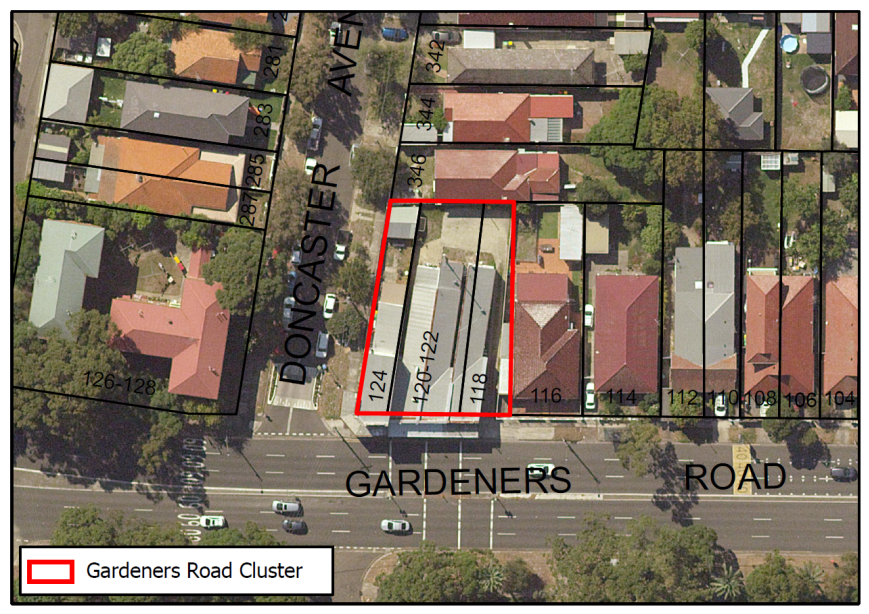
Table 1: Gardeners Road Cluster Proposed Controls
|
|
Existing Controls |
Proposed Controls |
|
Zoning |
R2 Low Density Residential |
B1 Local Business Centre |
|
Height |
9.5m |
9.5m |
|
FSR |
0.5:1 |
1:1 |
b) Todman Avenue Cluster, KENSINGTON
The Todman Avenue Cluster is located at the North-Western corner of Baker Street and Todman Avenue, and adjacent residential properties on the north and west. The cluster comprises 3 semi-detached shop-top housing buildings with commercial activity including a café, shop and gym on the ground floor, with active frontages towards Todman Avenue.
The site has the characteristics of a neighbourhood centre by way of building typology and current mix of land uses. Rezoning the site to B1 Neighbourhood Centre would protect employment lands within the residential area, which is integral given there are no other shops within reasonable walking distance (the closest centres being Kingsford Town Centre and the Supa Centre).
Figure 2: Todman Avenue Cluster Context Map
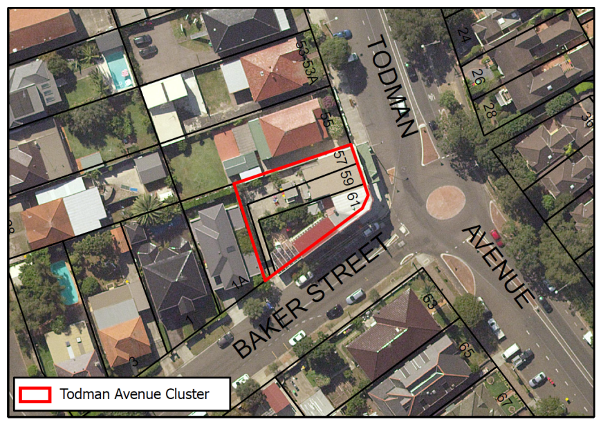
Table 2: Todman Avenue Cluster Proposed Controls
|
|
Existing Controls |
Proposed Controls |
|
Zoning |
R2 Low Density Residential |
B1 Local Business Centre |
|
Height |
9.5m |
9.5m |
|
FSR |
0.5:1 |
1:1 |
c) Anzac Parade Cluster, MAROUBRA
The Anzac Parade Cluster is bounded by Anzac Parade on the East, Runic Lane on the South, Mount Sinai College on the West, and residential properties to the north. The cluster comprises 3 semi-detached shop-top housing hosting six shops with commercial activity fronting Anzac Parade. The cluster reflects the character of a neighbourhood centre by way of building typology and mix of businesses. The cluster is in proximity to public transport and is about 250m from the Maroubra Town Centre.
Figure 3: Anzac Parade Cluster Context Map
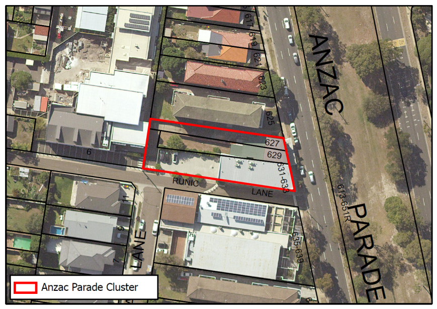
Table 3: Anzac Parade Cluster Proposed Controls
|
|
Existing Controls |
Proposed Controls |
|
Zoning |
R2 Low Density Residential |
B1 Local Business Centre |
|
Height |
9.5m |
9.5m |
|
FSR |
0.5:1 |
1:1 |
d) Bunnerong Road Cluster, MAROUBRA
The Bunnerong Road Cluster is located within the suburb of Maroubra and is bounded by Bunnerong Road on the West, Snape Street on the north, and adjacent residential properties on the South and East sides. The cluster comprises 1 shop-top housing building, a single storey commercial building with two-storey dwelling at rear, and a single dwelling, with commercial activity including a laundromat and a beauty salon. The building typology, urban form and current mix of land uses would be better suited to a neighbourhood centre zoning. There is a B1 Neighbourhood Centre immediately to the north, across Snape Street, and including these properties would form a natural extension of the existing neighbourhood centre.
Figure 4: Bunnerong Road Cluster Context Map
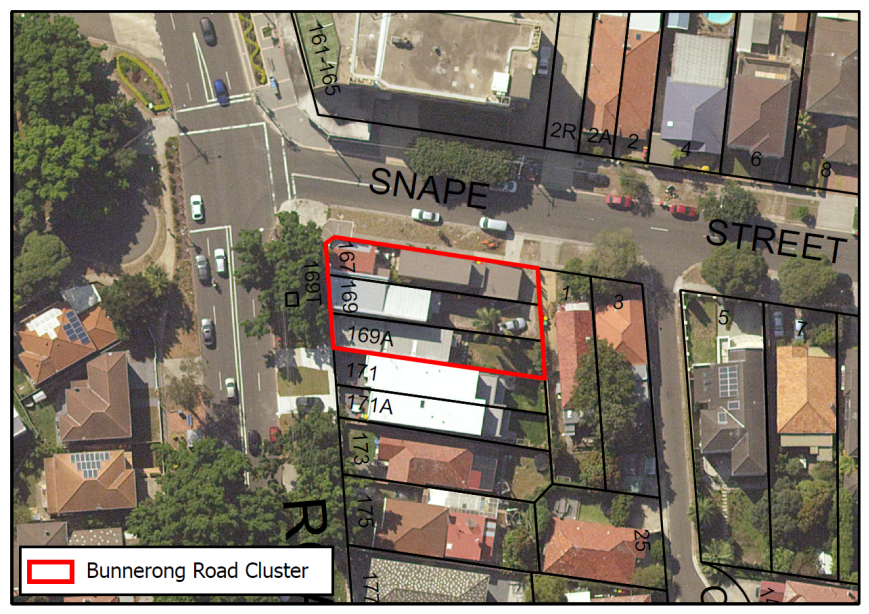
Table 4: Bunnerong Road Cluster Proposed Controls
|
|
Existing Controls |
Proposed Controls |
|
Zoning |
R2 Low Density Residential |
B1 Local Business Centre |
|
Height |
9.5m |
9.5m |
|
FSR |
0.5:1 |
1:1 |
e) Malabar Road Cluster, MAROUBRA
The Malabar Road Cluster is bounded by Malabar Road on the East, Mons Avenue on the West and South, and adjacent residential properties on the North. The site comprises one shop-top containing 5 separate shops on the ground floor with commercial activity including a trauma clinic, beauty clinic, and a hairdressed – all of them with active frontage towards Malabar Road. The cluster is in close proximity to public transport with a bus stop out the front. It is approximately 400m from the Maroubra Beach neighbourhood centre and located directly opposite a significant seniors housing development currently under construction.
The location, building typology, land use mix and access to public transport would support a neighbourhood business zoning for the site.
Figure 5: Malabar Road Cluster Context Map

Table 5: Malabar Road Cluster Proposed Controls
|
|
Existing Controls |
Proposed Controls |
|
Zoning |
R3 Medium Density Residential |
B1 Local Business Centre |
|
Height |
12m |
12m |
|
FSR |
0.9:1 |
1:1 |
f) Moverly Road Cluster, MAROUBRA
The Moverly Road Cluster is located within the suburb of Maroubra in the Central section of the LGA. It is bounded by Moverly Road on the South, Cooper Street on the West, and adjacent residential properties on the North and East sides. The cluster comprises 3 shop-top housing buildings with commercial activity including shops and a café, with active frontages towards Moverly Road.
The building typology, urban form and mix of businesses reflect the characteristics of a neighbourhood centre. Rezoning the cluster to a B1 Neighbourhood centre zone would protect employment lands and services within the neighbourhood catchment as there are no other shops within reasonable walking distance. The businesses have access to public transport with a bus stop located directly in front of the buildings.
Figure 6: Moverly Road Cluster Context Map

Table 6: Moverly Road Cluster Proposed Controls
|
|
Existing Controls |
Proposed Controls |
|
Zoning |
R2 Low Density Residential |
B1 Local Business Centre |
|
Height |
9.5m |
9.5m |
|
FSR |
0.5:1 |
1:1 |
g) Avoca Street Cluster, RANDWICK
The Avoca Street Cluster is bounded by Rainbow Street on the South, Avoca Street on the West, Rainbow Lane on the East, and adjacent residential properties on the North. The cluster comprises a double storey shop-top building and service station with commercial activity including a petrol station, convenience shop, and garage – all of them with an active frontage towards Avoca Street and Rainbow Street. The property is close to a bus stop and serves as the only neighbourhood shop in the area.
The site is a non-conforming use for a B1 zone. It is proposed to amend the Schedule 1 of the Randwick LEP to add “Petrol Station” as an additional permitted use and amend the LEP maps as well.
Figure 7: Avoca Street Cluster Context Map
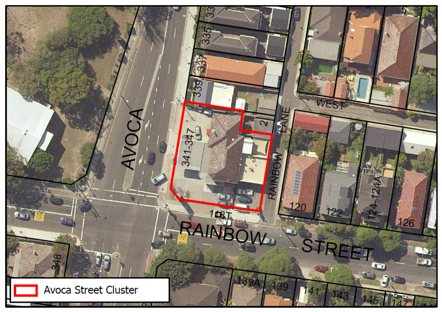
Table 7: Avoca Street Cluster Proposed Controls
|
|
Existing Controls |
Proposed Controls |
|
Zoning |
R2 Low Density Residential |
B1 Local Business Centre |
|
Height |
9.5m |
9.5m |
|
FSR |
0.5:1 |
1:1 |
|
Schedule 1- Additional Permitted Uses |
Nil |
Service Station as an additional permitted use. |
h) Barker Street Cluster, RANDWICK
The Barker Street Cluster comprises 3 double frontage shop-top buildings, including a vet clinic at 148 Barker Street, which are located on Barker Street to the east and west of Jane Street. Further to the east of 148 Barker Street is a row of commercial properties that are zoned B1 Neighbourhood Centre. To the west of Jane Street along Barker Street are residential properties. All commercial businesses within this cluster have active frontages to Barker Street. The buildings fall within the Struggletown Heritage Conservation Area.
148 Barker Street was previously subject to a planning proposal to rezone it from R2 Low Density Residential with an applicable height of 18m and removing the applicable FSR (27/06/2017). The planning proposal was not supported by Council at that time as it constituted a spot rezoning of an individual site, the building was deemed to contribute to the streetscape and heritage of the Struggletown Heritage Conservation Area, and a traffic study examining impacts of the Light Rail on Barker Street and the wider precinct had not been undertaken by the State Government.
Rezoning the cluster of businesses would provide a logical extension to the neighbourhood centre on Barker Street and provide a consistent zoning for the street frontage that appropriately reflects existing land uses, building typologies and character along this strip. It should be noted that any development application affecting these buildings would be subject to the heritage provisions under clause 5.10 heritage conservation of the RLEP 2012 and B1 Heritage Conservation controls under the DCP to ensure that the heritage character and significance of the buildings and the wider Struggle Town HCA is retained and protected.
Figure 8: Barker Street Cluster Context Map
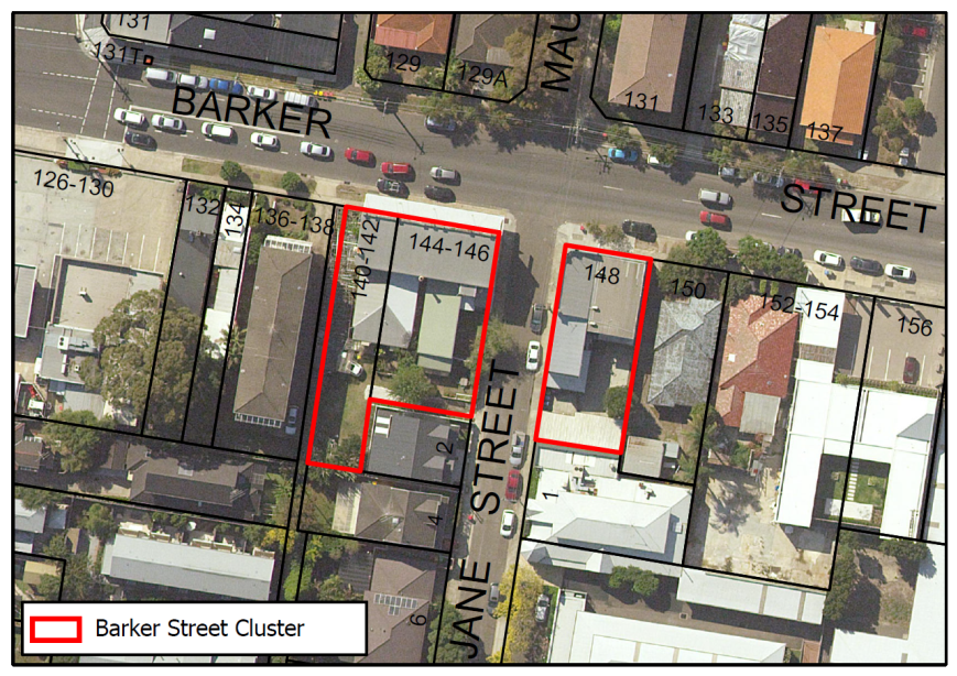
Table 8: Barker Street Cluster Proposed Controls
|
|
Existing Controls |
Proposed Controls |
|
Zoning |
R2 Low Density Residential |
B1 Local Business Centre |
|
Height |
9.5m |
9.5m |
|
FSR |
0.5:1 |
1:1 |
i) Canberra Street Cluster 1, RANDWICK
The Canberra Street Cluster 1 is bounded by Canberra Street on the West, Perouse Road on the North and East, and adjacent residential properties on the South. The cluster is composed of 4 shop-top housing buildings with commercial activity including a café, health care, and real estate agency – all of them with active frontage towards Canberra Street. The cluster is serviced by public transport (bus service) and is located approximately 300m from The Spot neighbourhood centre. The building typology, urban form and mix of business uses reflect the character of a neighbourhood business centre.
Figure 9: Canberra Street Cluster 1 Context Map
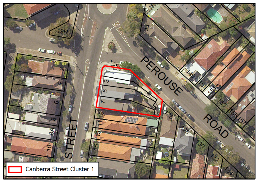
Table 9: Canberra Street Cluster 1 Proposed Controls
|
|
Existing Controls |
Proposed Controls |
|
Zoning |
R2 Low Density Residential |
B1 Local Business Centre |
|
Height |
9.5m |
9.5m |
|
FSR |
0.5:1 |
1:1 |
j) Canberra Street Cluster 2, RANDWICK
The Canberra Street Cluster 2 is bounded by Canberra Street on the East, Clarke Lane on the West, Oberon Street on the North, and Helena Street on the South. The cluster is composed of 4 shop-top housing buildings that occupy the whole block with active frontages towards Canberra Street. There is a bus stop directly at the buildings. The buildings are approximately 360m from The Spot neighbourhood centre. The building typology, urban form and current mix of land uses lend themselves to being a neighbourhood centre.
Figure 10: Canberra Street Cluster 1 Context Map
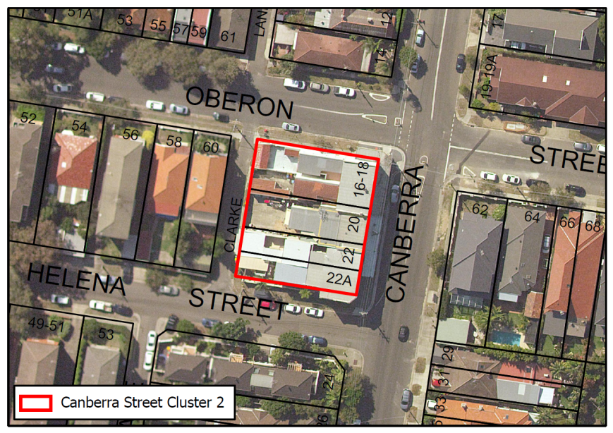
Table 10: Canberra Street Cluster 2 Proposed Controls
|
|
Existing Controls |
Proposed Controls |
|
Zoning |
R2 Low Density Residential |
B1 Local Business Centre |
|
Height |
9.5m |
9.5m |
|
FSR |
0.5:1 |
1:1 |
k) Carrington Road Cluster, RANDWICK
The Carrington Road Cluster is bounded by Frenchmans Road and Gilderthorpe Avenue on the South, Albion Street on the East, Hooper Lane on the West, divided by Carrington Road in its middle, and surrounded by adjacent residential properties on the North. The cluster comprises a Service station/garage and 2 shop top housing buildings, with commercial activity including a children’s art studio and an accountancy service – all of them with active frontages towards Carrington Road and Albion Street. The petrol station is currently a non-conforming use in the current R3 zone.
The building typology, urban form and mix of land uses reflect the characteristics of a neighbourhood centre. It is proposed to amend the Schedule 1 of the Randwick LEP to add “Petrol Station” as an additional permitted use.
Figure 11: Carrington Road Cluster Context Map
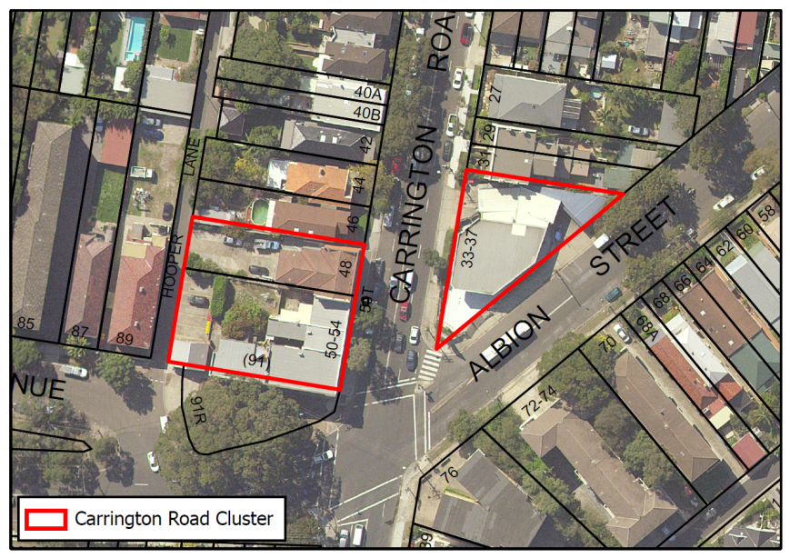
Table 11: Carrington Road Cluster Proposed Controls
|
|
Existing Controls |
Proposed Controls |
|
Zoning |
R3 Medium Density Residential |
B1 Local Business Centre |
|
Height |
12m |
12m |
|
FSR |
0.9:1 |
1:1 |
|
Schedule 1 (additional permitted use). |
Nil |
Service station (additional permitted use) |
l) Clovelly Road Cluster 1, RANDWICK
The Clovelly Road Cluster 1 is bounded by Clovelly Road on the South, Orange Lane on the East and is surrounded by adjacent residential properties on the North and West. The cluster comprises 2 shop top housing buildings with commercial activity having active frontages towards Clovelly Road. The North Randwick Clovelly Road Neighbourhood Centre is located across Clovelly Road.
The building typology, urban form and current land uses of this cluster of shops lend themselves to being a neighbourhood centre. The rezoning of the site to a B1 Neighbourhood Business Centre zone would also provide a logical extension to the North Randwick Clovelly Road Neighbourhood Centre, while protecting employment land in the locality.
Figure 12: Clovelly Road Cluster 1 Context Map
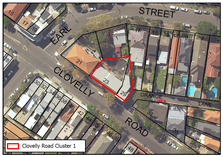
Table 12: Clovelly Road Cluster 1 Proposed Controls
|
|
Existing Controls |
Proposed Controls |
|
Zoning |
R2 Low Density Residential |
B1 Local Business Centre |
|
Height |
9.5m |
9.5m |
|
FSR |
0.5:1 |
1:1 |
m) Clovelly Road Cluster 2, RANDWICK
The Clovelly Road Cluster 2 is located at the junction of Clovelly Road, Market Street and Gilderthorpe Ave. The cluster comprises 4 shop-top housing buildings and 1 shop with a an community centre– all of which have active frontages towards Clovelly Road. The building typology, urban form and mix of land uses reflect the characteristics of a neighbourhood business centre focused around the junction that serves the needs of the locality.
Figure 13: Clovelly Road Cluster 2 Context Map
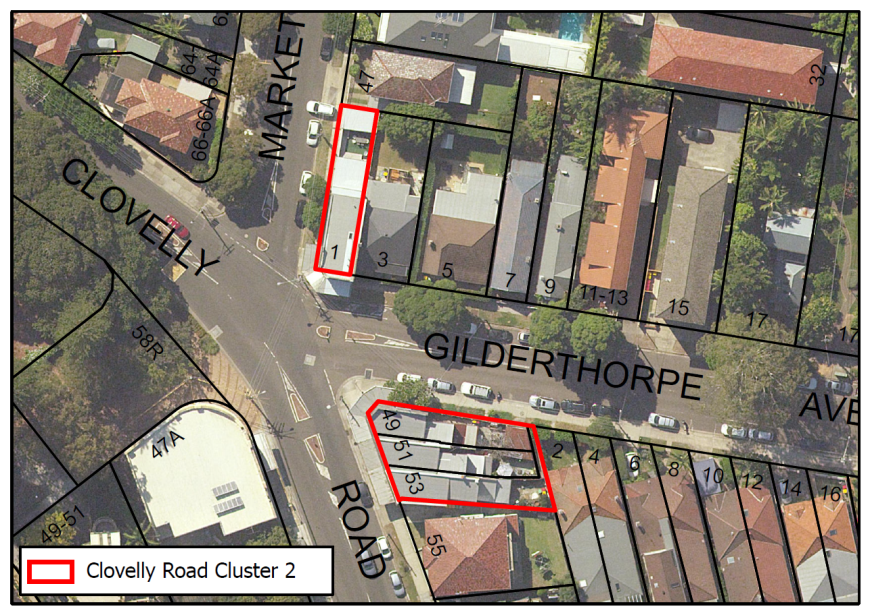
Table 13: Clovelly Road Cluster 2 Proposed Controls
|
|
Existing Controls |
Proposed Controls |
|
Zoning |
R3 Medium Density Residential |
B1 Local Business Centre |
|
Height |
12m North of Gilderthorpe Ave 9.5m South of Gilderthorpe Ave |
12m North of Gilderthorpe Ave 9.5m South of Gilderthorpe Ave |
|
FSR |
0.9:1 North of Gilderthorpe Ave 0.5:1 South of Gilderthorpe Ave |
1:1 |
n) King Street Cluster, RANDWICK
The King Street Cluster is bounded by King Street on the North, Church Street on the East, Prince Lane on the South, and adjacent residential properties on the West. The cluster comprises 3 shop top housing buildings with commercial activity including a laundromat and a café – all of them with active frontage towards King Street. There are no other neighbourhood centres or shops within reasonable walking distance.
Rezoning the site would reflect existing land uses and protect employment lands in an area where no other shops exist within close walking distance.
Figure 14: King Street Cluster Context Map
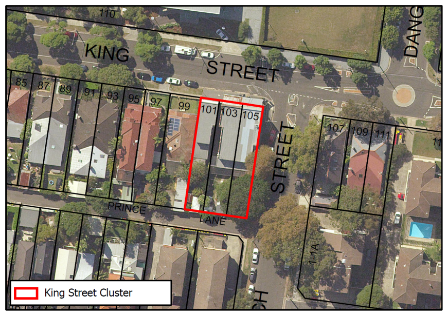
Table 14: King Street Cluster Proposed Controls
|
|
Existing Controls |
Proposed Controls |
|
Zoning |
R3 Medium Density Residential |
B1 Local Business Centre |
|
Height |
12m |
12m |
|
FSR |
0.9:1 |
1:1 |
o) Arden Street Cluster, SOUTH COOGEE
The Arden Street Cluster is located within the suburb of South Coogee in the East section of the LGA. The site is bounded by Malabar Road on the South and East, is divided by Athol Street and Arden Street, and is adjacent to residential properties on the North, East, and West sides. The cluster is composed by 4 shop top housing buildings with active frontagse towards Arden Street and Malabar Road.
The building typology, urban form and current mix of land uses of this cluster of shops refolect the characteristics of a neighbourhood centre. The buildings are linked by the Malabar Road and Arden Street regional road intersection and main entrance to the Cemetery. There are bus stops on both sides of Arden street.
Figure 15: Arden Street Cluster Context Map
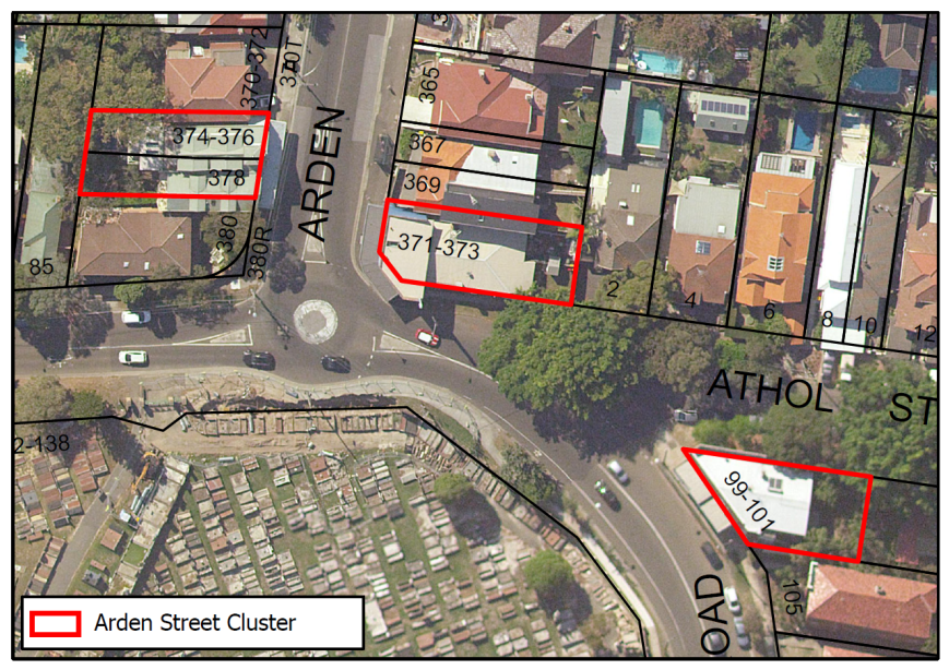
Table 15: Arden Street Cluster Proposed Controls
|
|
Existing Controls |
Proposed Controls |
|
Zoning |
R2 Low Density Residential |
B1 Local Business Centre |
|
Height |
9.5m |
9.5m |
|
FSR |
0.5:1 |
1:1 |
p) Malabar Road Cluster 1, SOUTH COOGEE
The Malabar Road Cluster 1 is located within the suburb of South Coogee in the East section of the LGA. The site is bounded by Malabar Road on the East, Rainbow Street on the North, Bundock Lane on the South, and adjacent residential properties on the West. The cluster is composed by 2 shop top housing developments with commercial activity including a news agent, physiotherapy practice, and a convenience store with active frontages towards Malabar Road.
The building typology, urban form and current land uses of this cluster of shops lend themselves to being a neighbourhood centre. The proposed neighbourhood zone is more than 500 meters away from any other business zone and would service the immediate locality.
Figure 16: Malabar Road Cluster 1 Context Map
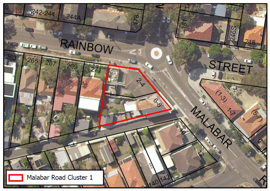
Table 16: Malabar Road Cluster 1 Proposed Controls
|
|
Existing Controls |
Proposed Controls |
|
Zoning |
R2 Low Density Residential |
B1 Local Business Centre |
|
Height |
9.5m |
9.5m |
|
FSR |
0.5:1 |
1:1 |
q) Malabar Road Cluster 2, SOUTH COOGEE
The Malabar Road Cluster 2 is located within the suburb of South Coogee in the East section of the LGA. The site is bounded by Malabar Road on the West, Bedford Place on the South, and adjacent residential properties on the East and North sides. The cluster comprises 1 service station/garage and 1 double-frontage shop top housing building with active frontages towards Malabar Road.
The building typology, urban form and current land uses of this cluster of shops lend themselves to being a neighbourhood centre and occupies a corner holding. The land area is significant in the context of surrounding residential properties for future developments.
The service station is a non-conforming use for a B1 zone. It is proposed to amend Schedule 1 of the Randwick LEP (Additional permitted uses) to include “service station” as an additional permitted use to recognise the existing use.
Figure 17: Malabar Road Cluster 1 Context Map
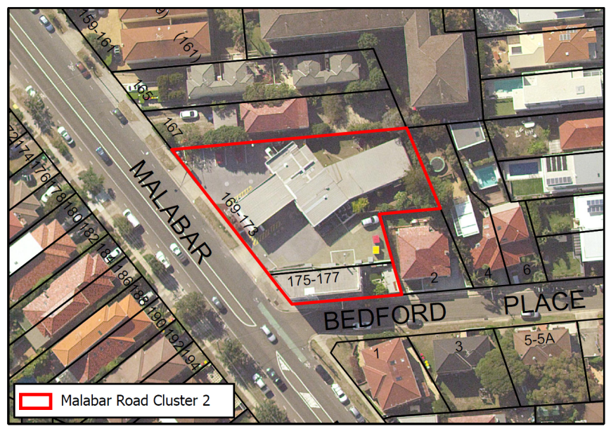
Table 17: Malabar Road Cluster 2 Proposed Controls
|
|
Existing Controls |
Proposed Controls |
|
Zoning |
R2 Low Density Residential |
B1 Local Business Centre |
|
Height |
9.5m |
9.5m |
|
FSR |
0.5:1 |
1:1 |
|
Schedule 1 (Additional Permitted Uses) |
Nil |
Service station (additional permitted use) |
r) Burnie Street Cluster, CLOVELLY
The Burnie Street Cluster is located within the suburb of Clovelly in the North East section of the LGA. The site is bounded by Clovelly Road on the South, is adjacent to residential properties on the North, East, West, and South, and is divided by Burnie Street and Clifton Road. The cluster is comprises shop-top housing buildings and one vacant block with commercial activity including an art gallery, decoration shop, and food market. An additional 4 properties are currently residential and have been excluded from the proposed changes- these properties are identified with the hatched areas.
This is a cluster with several properties and can benefit largely from Night-time Economy activities. The site falls within the Burnie Street Heritage Conservation Area.
Figure 18: Burnie Street Cluster Context Map
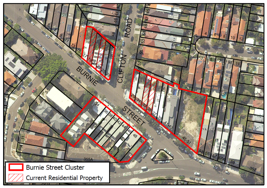
Table 18: Burnie Street Cluster Proposed Controls
|
|
Existing Controls |
Proposed Controls |
|
Zoning |
R2 on North side of Burnie St R3 on South side of Burnie St |
B1 Local Business Centre |
|
Height |
9.5m |
9.5m |
|
FSR |
0.5:1 on North side of Burnie St 0.75:1 on South side of Burnie St |
1:1 |
s) Beach Street Cluster, COOGEE
The Beach Street Cluster is located within the suburb of Coogee in the North East section of the LGA. The site is bounded by Beach Street on the East, Arcadia Street on the North, and adjacent residential properties on the South and West sides. The cluster is composed by one property holding three shops with commercial activity fronting Beach Street.
The building typology, urban form and current land uses of this cluster of shops lend themselves to being a neighbourhood centre. Although it is 150 meters away from the Coogee Beach B2 zone, this centre has its own character, serves a more local population, and occupies a corner holding with easy access to public parking. It is also under single ownership.
Figure 19: Beach Street Cluster Context Map
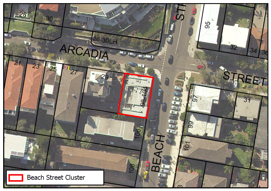
Table 19: Beach Street Cluster Proposed Controls
|
|
Existing Controls |
Proposed Controls |
|
Zoning |
R3 Medium Density Residential |
B1 Local Business Centre |
|
Height |
12m |
12m |
|
FSR |
0.9:1 |
1:1 |
t) Dudley Street Cluster, COOGEE
The Dudley Street Cluster is located within the suburb of Coogee in the North East section of the LGA. The site is bounded by Dudley Street on the South, Havelock Avenue on the North, and adjacent mixed-use properties on the east and West. The cluster comprises 3 residential flat buildings (multi-unit housing) with 5 shops on the ground floor with frontages onto Dudley Street and Havelock Avenue.
The building typology, urban form and current land uses of this cluster of shops lend themselves to being a neighbourhood centre. The buildings are adjacent to the B1 zone at Havelock Avenue and are a natural extension of the zone.
Figure 20: Dudley Street Cluster Context Map
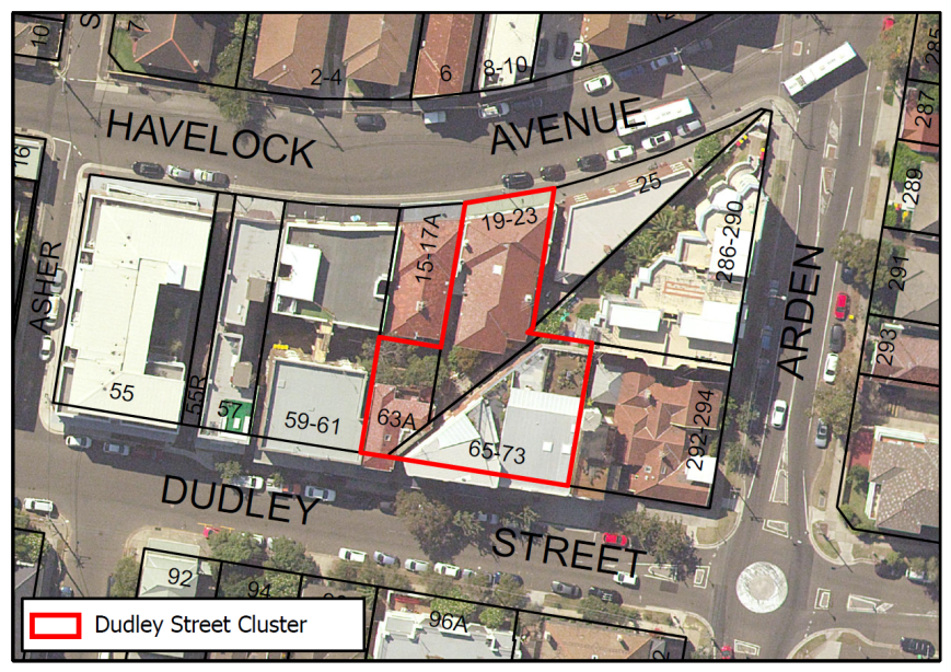
Table 20: Dudley Street Cluster Proposed Controls
|
|
Existing Controls |
Proposed Controls |
|
Zoning |
R3 Medium Density Residential |
B1 Local Business Centre |
|
Height |
12m |
12m |
|
FSR |
0.9:1 |
1.5:1 |
4. Randwick Hospital Campus Expansion
Background
In 2017 the NSW Government committed $720 million towards the redevelopment and expansion of the Randwick Hospitals Campus (Prince of Wales Reconfiguration and Expansion Project) to accommodate a 13 storey (59m) Integrated Acute Services Building (ASB) and associated works including expanded emergency and intensive care unit departments, four new operating theatres, helipad, research, education and training facilities, and contemporary facilities for a number of specialties. In addition, the expansion will include new state of art pediatric health, medical research and education facilities as part of the Sydney Children’s Hospital Stage 1 and the Children’s Comprehensive Cancer Centre redevelopment project, as well as a new ‘Health Translation Hub’ (HTH) to physically integrate the hospitals campus with the UNSW with purpose built education, training and research facilities, clinical schools, retail premises and over 2,500m2 of publicly accessible open space.
To facilitate the campus extension, 89 residential properties were compulsorily acquired which now form a block known as the ‘campus expansion area’ located immediately to the west of the existing Randwick Hospital campus (Figure 21). This block (currently under construction), is bounded by High Street, Hospital Road, Magill Street and Botany Street. The UNSW Kensington Campus is situated immediately to the west, the Arthur Street housing investigation area (HIA) is to the north, the Randwick Junction Town Centre is to the northeast and the Magill Street HIA is to the south. The site is well serviced by public transport including the Sydney CBD to South East Light Rail and frequent bus services. There are no heritage items within the hospital campus expansion area.
The campus expansion area is currently zoned R2 Low Density Residential and R3 Medium Density Residential under the RLEP 2012 with an applicable height limit of 9.5m and 15m respectively. An FSR of 0.5:1 applies to that part of the block that is currently zoned R2 Low Density Residential. The current zoning and applicable development standards are inconsistent with the approved development and intended desired future character of the block.
An amendment to the RLEP 2012 zoning and development standards of the campus expansion area is therefore warranted to reflect the desired future character for the block. The proposed health, education and research facilities form an extension of the existing hospital campus which is currently zoned SP2 Infrastructure under RLEP 2012. Rezoning the campus extension area to SP2 Infrastructure would reflect the intended uses and provide certainty and consistency in zoning application and reflect the intended outcomes of this area as a well-integrated health, education and research precinct.
Figure 21: Randwick Hospital Campus Expansion Area
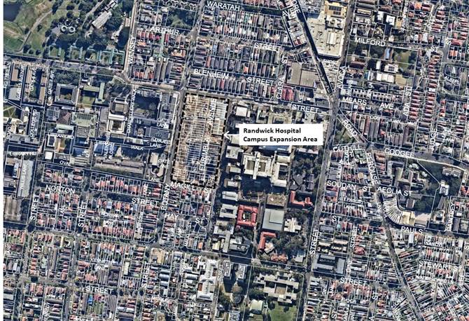
Proposed Amendments to the RLEP 2012- Randwick Hospitals Expansion
It is proposed to amend the RLEP 2012 in relation to the Hospital campus expansion area to match controls that currently apply to the Hospital campus as follows:
· Rezone the block from R2 Low Density Residential and R3 Medium Density Residential to SP2 Health Services Facility (refer to figures 22 and 23);
· Remove the existing residential (9.5m and 15m) Height of Building (HOB) controls for the Randwick Hospital Campus Expansion Area and remove part of the current Randwick Hospital western perimeter height control (Refer Figures 24 and 25) to reflect the SSD process and zoning protocols.
· Remove the applicable FSR in line with the protocol for all special purpose and infrastructure zones. Refer Figure 26 and 27.
Figure 22: RLEP zoning map – existing
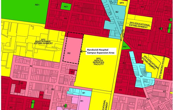
Figure 23: RLEP zoning map – proposed
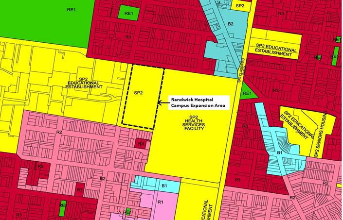
Figure 24: RLEP Height of Building map – existing
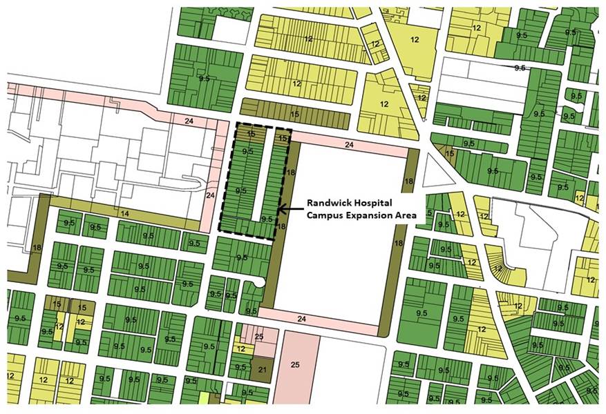
Figure 25: RLEP Height of Building map – proposed
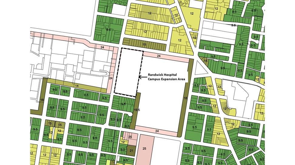
Figure 26: RLEP FSR map - existing
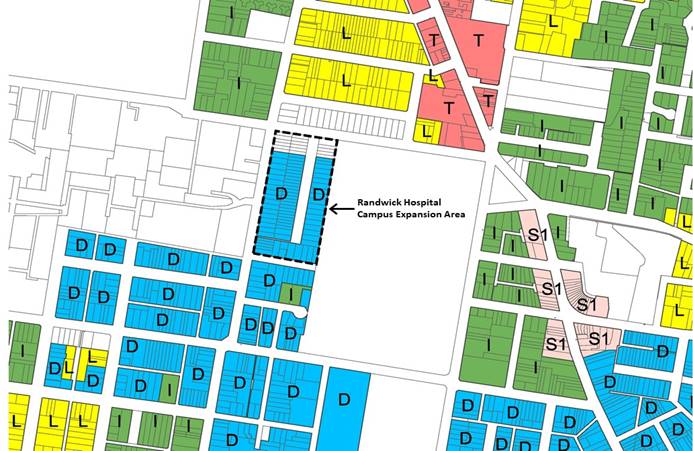
Figure 27: RLEP FSR map – proposed
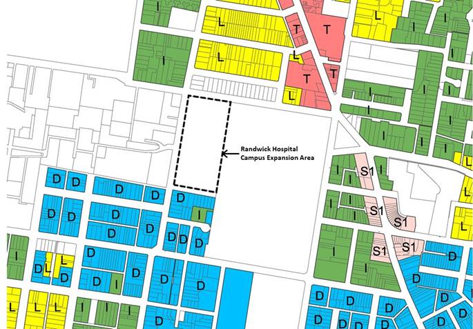
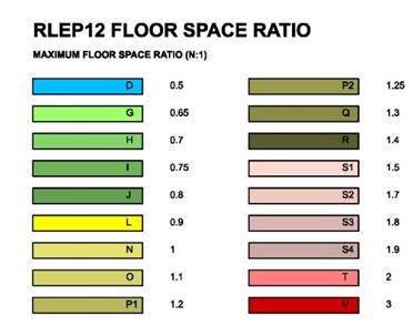
Table 21: Summary of Proposed Randwick Hospital Campus Expansion Controls
|
|
Existing controls |
Proposed controls |
|
Zoning |
R2 Low Density Residential R3 Medium Density Residential |
SP2 Health Services Facility |
|
Height |
9.5m 15m |
No height control in expansion area.
|
|
FSR |
0.5:1 No FSR control |
No FSR control in expansion area |
5. Royal Randwick Racecourse
The Spectator Precinct – Additional Permitted Uses
Racecourses throughout metropolitan Sydney are reinventing themselves to stay relevant to the communities they serve and to keep afloat financially. Royal Randwick Racecourse has modernised with new enclosed spectator stands with high quality function and catering services, and large screen video facilities. There are significant costs involved in maintaining the racetrack and horse stabling facilities, and the Australian Turf Club (ATC) generates income to pay for this through holding regular race days, various events and occasional festivals held on the site during the course of the year.
A hotel and function centre has been approved by the State Government as a State Significant Development (2014) on the Alison Road side of the racecourse. Once constructed this development would broaden the land use mix on the site. The new Light Rail service, with the station adjacent to the site, provides enhanced access to the racecourse from the Sydney CBD.
The Spectator Precinct is in the north of the Royal Randwick Racecourse, to the northwest of the racetracks. It is bounded by the racetrack, Alison Road, the Light Rail Stabling Facility and by the rear of residential properties that front onto Doncaster Avenue. The grandstand in the east of the Spectator Precinct is a heritage item and the whole Royal Randwick Racecourse is within the Racecourse Precinct Heritage Conservation Area.
The ATC is proposing to further expand the mix of entertainment, food and drink and office space services provided on the site to build upon the well established profile of the Racecourse in hosting high quality racing and other allied events and functions. The ATC has advised that this would offer a number of economic benefits such as:
· Generating additional construction (temporary), ongoing hospitality and related employment opportunities;
· Providing an enhanced recreational destination;
· Supporting economic growth through attracting visitor and tourism to Randwick City;
· Leveraging existing racecourse infrastructure with more continuous uses throughout the year and enhancing the reputation of the site as a high quality entertainment venue;
· Providing an additional drawcard attracting hospital and university workers to live and work in the Collaboration Area;
· Providing high quality commercial office space;
· Establishing a critical mass of inter-related entertainment and associated land uses that create a lively venue throughout the year; and
· Contributing to the night-time economy in a contained venue.
The Royal Randwick Racecourse is currently zoned RE1 Public Recreation where uses such as food and drink premises, entertainment facilities and commercial premises are currently not permitted within the zone.
Schedule 1 of the RLEP 2012 currently contains a number of ‘additional permitted uses’ that are permissible on the site. These include registered club for the entire site, and hotel or motel accommodation, serviced apartments and function centres for a designated east portion of the Spectator Precinct (Area A).
The ATC has requested that Council consider an amendment to Schedule 1 of the RLEP 2012 (‘Additional permitted uses”) and accompanying map to permit entertainment facilities, food and drink premises and commercial premises with development consent in the ‘Spectator Precinct’ of Royal Randwick Racecourse (RRR). These land uses would comprise the following:
Table 22: Proposed land uses
|
Entertainment facilities |
Food and drink premises |
Commercial premises |
|
Theatre, cinema, music hall, concert hall, dance hall and the like. |
Restaurants, cafes (both currently permitted with consent), take away food and drink, and bar associated with hotel. |
Office space for ATC, plus additional office floor space for separate tenants. |
The proposed additional uses at the Spectator Stand would establish a broader offering of activities (rather than focusing solely on racing), creating a more sustainable and continuous presence on the site. It is important to note that permitting additional uses on the site would not give the green light for development to proceed. Any proposal for entertainment facilities, food and drink premises and commercial premises would be still subject to a DA where built form, height, density and amenity impacts are assessed separately.
Given the nature of additional uses requested, further consideration of the proposal is required to holistically ascertain its impacts on the economic competitiveness of Randwick Junction, any implications on the hierarchy of centres and impacts on residential amenity and the wider Randwick Strategic Centre. There is insufficient details of the proposed development available at this time to fully assess the potential impacts. Accordingly, it is recommended that the proposal be considered as a separate future Planning Proposal for the precinct.
Figure 28: Spectator Precinct (identified in yellow tone)
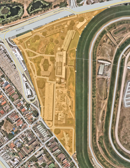
Figure 29: RLEP Additional Permitted Uses Map – existing
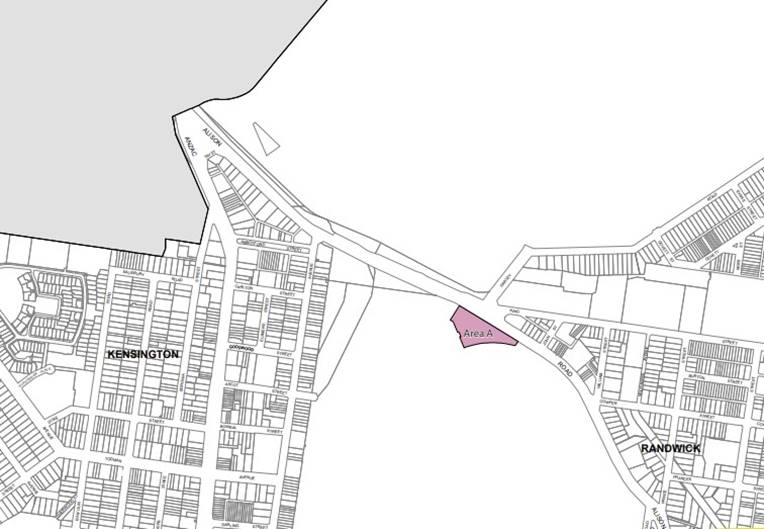
Figure 30: RLEP Additional Permitted Uses Map – proposed
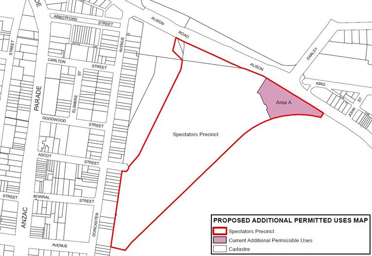
Light Rail Stabling Facility
The Light Rail Stabling Yard is in the north corner of the Royal Randwick Racecourse and has a frontage to Alison Road (see figure 31). It has vehicular access to Doncaster Avenue and Ascot Street. It is located at the rear of residential properties along Doncaster Avenue (there is a concrete noise wall along the rear of the properties) and adjoins Royal Randwick Racecourse forecourt operations, including pavilions/kiosks, amphitheater, lawns, arrival/assembly areas and multi-level carpark.
The stabling yard and associated facilities buildings support the operations of the CBD and South East Light Rail and connect to the CBD to Randwick Light Rail route along Alison Road.
The Stabling Yard and associated Light Rail facilities are located within the Racecourse Precinct Heritage Conservation Area. Three residential properties along Doncaster Avenue are heritage listed, as is the northern racecourse grandstand. Centennial Park, to the north of Alison Road, is also heritage listed and within the North Randwick HCA.
It is proposed to rezone the Stabling Yard from RE1 Public Recreation to SP2 Infrastructure in the area indicated on the zoning maps (Figures 32 and 33). The CBD and South East Light Rail provides an important public transport service for the Randwick community, connecting residents, businesses, and institutions in the north of the Randwick City LGA to the Sydney CBD. Stabling Yards and associated Light Rail facilities are needed to support the Light Rail service. The proposed SP2 zone would correct an anomaly in the current zoning, and recognise the existing land use of the CBD and South East Light Rail stabling yard and associated facilities infrastructure on the subject land.
No Height of Building (HOB) or FSR control is proposed for the Stabling Yard site, in line with the transport infrastructure land use and zoning protocol.
Figure 31: Light Rail Stabling Yard – urban context
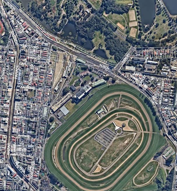
Figure 32: RLEP Zoning - existing
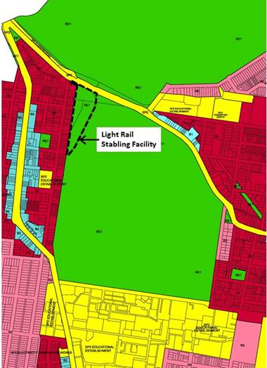
Figure 33: RLEP Zoning - proposed
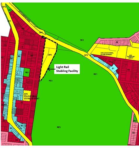
Relationship with the Strategic Framework
Eastern District Plan
This Planning Proposal is support and facilitate economic development is consistent with the objectives and actions of the following priorities of the Eastern City District Plan.
Table 23: Consistency with Eastern City District Plan
|
Eastern District Plan |
Consistency |
|
Planning Priority E1 – Planning for a city supported by infrastructure |
The planning proposal supports the Government’s objectives for aligning growth with infrastructure by recognizing and acknowledging the light rail stabling as vital infrastructure through a SP2 Infrastructure zoning. |
|
Planning Priority E2 – Working through collaboration |
The planning proposal implements the Collaboration Area Place Strategy developed with key partners by the GSC by supporting the Randwick Hospital Campus expansion through appropriate zoning and controls for new development that will accommodate new health, education, and research facilities. |
|
Liveability priority E3 – Provide services and social infrastructure to meet peoples changing needs. |
This planning proposal encourages the provision of services and social infrastructure including later opening shops, small scale cultural activities and gallery and maker spaces. The proposed new B1 Neighbourhood Centre zoning for identified clusters of shops would help protect employment lands that service the retail, social and community needs of residential neighbourhood catchments across the City. |
|
Liveability priority E4 - Fostering healthy, creative, culturally rich and socially connected communities |
This planning proposal would help enable a healthy, creative, culturally rich, socially connected community by: · Fostering diversification of the night-time economy and increasing wider participation by encouraging low impact uses and cultural activities to take place in the evening; · Providing social infrastructure and improving community accessibility to the arts, by making it easier to host small scale cultural activities, and establish galleries and maker spaces in residential areas; · Protecting the existing stock of neighbourhood centres which provide important opportunities for social interaction and services through appropriate zoning and controls; · Enhancing Randwick City’s sense of community by limiting the number of unhosted days for short term rental accommodation. |
|
Liveability priority E5 – Providing housing supply, choice and affordability with access to jobs, services and public transport
|
The planning proposal seeks to balance the economic benefits of short-term rental accommodation on our visitor economy with protecting medium to long term rental housing supply in high amenity areas. This would result in greater supply, choice, affordability, and stability in the local rental housing market and help protect the liveability and character of residential areas. |
|
Liveability priority E6 - Creating and renewing great places and local centres, and respecting the District’s heritage |
This planning proposal would assist in creating great places and local centres by: · Encouraging a vibrant night time economy and activation of street life through diverse uses and cultural activities that encourage wider community participation; · Retaining the existing quantity of employment lands within residential neighbourhood settings which are important for servicing the community’s retail, business, entertainment needs; · Improving walkability, activation of street life, social and economic participation; · Supporting local businesses both the day and night-time economy. |
|
Productivity priority E8 - Growing and investing in health and education precincts and the innovation corridor |
The planning proposal facilitates growth and investment of the Randwick Health and Education Precinct by: · Supporting the Randwick hospital expansion through appropriate zoning and controls for new development to accommodate the Government’s significant investment in education, health services and research facilities; · Diversifying the night time economy to encourage widespread participation through later opening hours and encouraging social and cultural activities. This in turn would support local businesses, retains spending and investment within the precinct, increases visitation and job creation. |
|
Productivity Priority E10 – Delivering integrated land use and transport planning and a 30-minute city |
The planning proposal will support the integration of land use and transport planning through rezoning clusters of shops to B1 Neighbourhood Centre. The new B1 neighbourhood centres are located within a 400m radius from R2 and R3 residential zones and will enable a reduced need for people to travel long distances to access local services and jobs.
|
|
Productivity priority 11 - Growing investment, business opportunities and jobs in strategic centres |
The Eastern City District Plan job targets for the Randwick Collaboration Area were: · 2016 estimate of 22,800, · 2036 baseline target of 32,000 with a higher target of 35,500. The Randwick Hospitals Campus expansion project, retention of neighbourhood centre employment lands, and additional permissible uses at the Randwick Racecourse spectator precinct will protect and enhance capacity for employment growth. The proposal additionally provides a suitable environment that encourages the establishment of creative industries and supports a diverse range of small businesses, such as retail, and cultural events. |
Randwick Local Strategic Planning Statement
The Randwick City Local Strategic Planning Statement (LSPS) sets out a 20-year land use vision for the city through local planning priorities and actions. It gives effect to and links the Greater Sydney Commission's Region and District Plans to Randwick City's local planning controls.
The Randwick LSPS will also guide the review of the City’s planning controls, inform decisions about infrastructure and set out how we will collaborate with relevant stakeholders in planning for the city’s liveability, productivity and sustainability. This planning proposal gives effect to the following LSPS local priorities and actions.
Table 24: Consistency with Randwick City LSPS
|
Priorities |
Actions |
Planning Proposal |
|
Planning Priority 1: Provide diverse housing options close to transport, services and facilities |
Action 1.2: Work with the Department of Planning, Industry and Environment to seek an exclusion for Randwick City LGA from the provisions of the Affordable Rental Housing SEPP and develop a local response to the provision of boarding houses. |
The proposal sets limits on the number of days within a calendar year that a non-hosted STRA is permitted to operate in order to retain availability of rental properties and minimise long term impacts on amenity and neighbourhood character. |
|
Planning Priority 6: Support the delivery of social infrastructure to meet the needs of our diverse community |
Action 6.4 Review land use classification of Special Purpose zoned land to identify opportunities for new and/or shared use of facilities |
The Light Rail Stabling Yard is being rezoned to SP2 Infrastructure, to reflect existing uses and recognise important infrastructure that exists on the land.
|
|
Planning Priority 8: Plan for and support strong connections to support a 30-minute city |
Action 8.2 Integrate land use, infrastructure and transport projects to deliver the 30-minute city |
The Proposal responds to the delivery of strategic transport projects – in particular the Light Rail – and aims at integrating appropriate land uses in surrounding areas to support the 30-minute city. |
|
Planning Priority 9: Focus economic development, innovation, and jobs growth in strategic centres |
Action 9.1 Deliver key priorities from the Randwick Collaboration Area Place Strategy and Structure Plan Action 9.2 Review the land use zoning and planning controls of the Randwick Health and Education Strategic Centre
|
The proposal responds to these priorities by rezoning the Randwick Hospitals Campus expansion area with appropriate development standards to accommodate significant investment towards health, research and education facilities. |
|
Planning Priority 10: Support the long-term economic viability of our town and neighbourhood centres |
Action 10.1 Finalise the Economic Development Study and prepare an updated Randwick City Economic Development Strategy to: · plan for capacity for future retail and commercial redevelopment in town and local centres · make strategic recommendations on the future economic profile of Randwick City’s network of local centres · ensure our town and neighbourhood centres remain vibrant and build on their character and sense of place Action 10.2 Prepare a Local Centre Study to identify the current and future role of our centres, and opportunities to respond to the growing housing and employment demand |
The proposal implements findings from the Neighborhood Centres Study and protects the existing stock of neighbourhood centres through appropriate zoning and controls that reflect land use mix, building typology and character. The proposal ensures that the town and neighbourhood centres remain vibrant and builds on their character and sense of place as an asset to encourage more visitors and a more vibrant social, cultural, and economic activity. The Proposal also responds to the need to centres by facilitating the development and diversification of the night time economy.
|
|
Planning Priority 11: Develop a diverse, thriving, and inclusive night-time economy |
Action 11.1 Prepare an Economic Development Strategy incorporating the outcomes of the Night-Time Economy Study, to: · Include overarching objectives on supporting a diverse night-time economy in the LEP and DCP · Introduce Exempt Development provisions to allow retail to stay open until 11pm without requiring development consent · Introduce Exempt Development provisions to allow small scale cultural activities to occur in retail and low impact businesses without requiring development consent |
The Proposal articulates and responds to the findings of the Night Time Economy Study 2019 and sets the conditions for diversification to encourage wider participation, while minimising impacts on infrastructure and amenity. Exempt development provisions to allow longer opening hours and small-scale cultural activities to occur in retail and low impact businesses without requiring development consent have been included in the Proposal. |
|
Planning Priority 12: Manage and enhance the tourism and visitor economy |
Action 12.1 Undertake a Visitor Management Study as part of an Economic Development Strategy to identify opportunities to implement place-based initiatives and improve visitor experiences including: · provision of well-designed and located supporting facilities; enhanced amenity, vibrancy and safety of places · provision of places for artistic and cultural activities · protection of heritage and biodiversity to enhance cultural and eco-tourism · growth of the night-time economy · improved public transport to serve the transport access needs of tourists · - a coordinated approach to tourism activities, events and accommodation |
The proposal allows for more cultural uses and night time activities, which in turn will foster the provision of spaces for artistic and cultural activities. The proposal provides a balanced approach to tourist accommodation by permitting short term tourist accommodation (unhosted) for 90 days a year to protect residential amenity, stock of rental housing, sense of community and neighbourhood character.
|
|
Planning Priority 23: A collaborative approach to guide and manage future growth in Randwick City |
Action 23.1 Work with the key stakeholders of the Randwick Collaboration Area to deliver the Randwick Collaboration Area Place Strategy |
The proposal responds to the needs of the key stakeholders, in particular the Randwick Hospital Campus Expansion, the Royal Randwick racecourse, and the Light Rail Stabling Infrastructure. |
See Policy and Legislative requirements of this report for an analysis of consistency with State Environment Planning Policies and Ministerial Directions.
Environmental, Economic and Social Impacts
Critical habitat, threatened species, populations or ecological communities, or their habitat
The planning proposal applies to residential and business zones within a highly urbanised area. The proposed changes to RLEP 2012 zoning, development standards and provisions as a result of the planning proposal will not adversely impact critical habitat, threatened species, populations or ecological communities or their habitats as there is none in the planning proposal area or vicinity.
Environmental Effects
It is considered that there will be minimal environmental effects as a result of the planning proposal, as development resulting from proposed changes to zoning, standards and provisions would occur within areas that are already developed. Any environmental effects arising from individual development applications would be addressed as part of the merit based assessment process.
Social and Economic Effects
Night Time Economy
As noted earlier in this report, proposals to support a thriving and diverse night time economy would have wide ranging socio economic benefits for providers and users. Expanding services after dark, particularly in the arts, culture, retail and entertainment sectors, would help increase productivity, and job creation, while also contributing positively to the social and cultural fabric of our cities.
Growth and diversification of the night time economy would support increased patronage of local businesses over longer and different time periods, stimulating job creation, particularly flexible employment; provides an additional source of revenue for Local Government; supports cultural and creative sectors; boosts local tourism; and further drives local industries such as food, beverage, and retail and none-core activities such as transport and security.
In terms of social benefits, a diverse range of evening activities and experiences provides greater social connection and engagement opportunities, helping to enhance community life and increasing participation. These outcomes are particularly important for our community with its mix of cultures, religions, age groups and abilities.
The night time economy has strong synergies with the music and creative sectors. The emersion of arts, live music, performance and cultural events provides opportunities for artistic exchange and expression, while encouraging the community to enjoy the cultural life of the City. Importantly a night time economy that is diverse and welcoming promotes greater citizen security and improves perception of personal safety. By encouraging a wider demography to frequent local businesses, social/cultural venues and public spaces, our streets are lively and safer in the evening time.
Short Term Rental Accommodation
Placing limitations on the length of time for non-hosted short term rental accommodation would offer significant benefits including helping to retain availability of medium and long term rental housing, protecting the sense of community and character of localities.
Neighbourhood Centres
The recognition of neighbourhood centres through appropriate zoning and development standards would maintain and enhance a mix of businesses that constitute local employment opportunities which are contributing factor to a stable and diverse local economy. It would help ensure that each identified neighbourhood centre’s unique elements and identity are strengthened, support local businesses, enhance walkability within neighbourhoods and promote social interaction through service offerings on a more intimate human scale personal than those offered in a ‘big box’ shopping centre.
Randwick Hospital Campus Expansion
The zoning and provisions for the Randwick Hospital’s expansion area would offer substantial economic benefits by reflecting the type of development, intensity and scale required to accommodate the State Government’s substantial investment in new health, education and research facilities. These state of the art facilities would have positive impact on the local community in terms of health and well being outcomes.
In order for the Randwick Health and Education Centre to maintain its international standarding as research and teaching excellence centres and supporting local businesses to grow, it must have the ability to retain a stable workforce to help run it. The future development and growth of the hospitals campus will generate a demand for more employment floor space for retail, commercial and medical uses within the precinct and also for services typically staffed by lower income earners, such as cafe workers and shop assistants.
State and Commonwealth interests
The planning proposal should nominate the state and Commonwealth agencies to be consulted and outline the particular land use issues or site conditions which have triggered the need for the referral. The proposed agency consultation will be confirmed with the Gateway determination.
Strategic alignment
The relationship with the City Plan is as follows:
Table 25: Relationship with City Plan
|
Outcome/Direction |
Delivery Program actions |
|
Outcome |
8. A strong local economy. |
|
Direction |
8a. Vibrant business, commercial and industrial sectors that provide ongoing and diverse employment opportunities and serve the community. |
Resourcing Strategy implications
The costs associated with the preparation of the Economic Development Study was funded from the 2019/2020. This draft Planning Proposal was prepared by the Strategic Planning team.
Policy and legislative requirements
State Environmental Planning Polices (SEPPs)
An analysis of the consistency of the proposed amendments with the relevant State Environmental Planning Policy (SEPPs) is provided below with the full list to be provided with the Comprehensive Planning Proposal to be reported in May 2021.
Table 26: Consistency with State Environmental Planning Policies (SEPPs)
|
Policy |
Comment |
|
State Environmental Planning Policy (Aboriginal Land) 2019 |
N/A |
|
State Environmental Planning Policy (Activation Precincts) 2020 |
N/A |
|
State Environmental Planning Policy (Affordable Rental Housing) 2009 |
N/A – See response to the draft State Environmental Planning Policy (Short Term Rental Accommodation 2019) below table. |
|
State Environmental Planning Policy (Building Sustainability Index: BASIX) 2004 |
N/A |
|
State Environmental Planning Policy (Coastal Management) 2018 |
N/A |
|
State Environmental Planning Policy (Concurrences and Consents) 2018 |
N/A |
|
State Environmental Planning Policy (Educational Establishments and Child Care Facilities) 2017 |
N/A |
|
State Environmental Planning Policy (Exempt and Complying Development Codes) 2008 |
The planning proposal is consistent with the SEPP. Any Development Applications that are submitted as a result of the proposed LEP amendment will need to consider the Development Codes as required by the SEPP. |
|
State Environmental Planning Policy (Gosford City Centre) 2018 |
N/A |
|
State Environmental Planning Policy (Housing for Seniors or People with a Disability) 2004 |
N/A |
|
State Environmental Planning Policy (Infrastructure) 2007 |
The planning proposal does not affect the operation of the SEPP and is consistent with the SEPP. Future development will need to consider the SEPP. |
|
State Environmental Planning Policy (Koala Habitat Protection) 2020 |
N/A |
|
State Environmental Planning Policy (Kosciuszko National Park—Alpine Resorts) 2007 |
N/A |
|
State Environmental Planning Policy (Kurnell Peninsula) 1989 |
N/A |
|
State Environmental Planning Policy (Major Infrastructure Corridors) 2020 |
N/A |
|
State Environmental Planning Policy (Mining, Petroleum Production and Extractive Industries) 2007 |
N/A |
|
State Environmental Planning Policy No 19—Bushland in Urban Areas |
N/A |
|
State Environmental Planning Policy No 21—Caravan Parks |
N/A |
|
State Environmental Planning Policy No 33—Hazardous and Offensive Development |
N/A |
|
State Environmental Planning Policy No 36—Manufactured Home Estates |
N/A |
|
State Environmental Planning Policy No 47—Moore Park Showground |
N/A |
|
State Environmental Planning Policy No 50—Canal Estate Development |
N/A |
|
State Environmental Planning Policy No 55—Remediation of Land |
N/A |
|
State Environmental Planning Policy No 64—Advertising and Signage |
The planning proposal does not affect the operation of the SEPP and is consistent with the SEPP |
|
State Environmental Planning Policy No 65—Design Quality of Residential Apartment Development |
The planning proposal does not affect the operation of the SEPP and is consistent with the SEPP |
|
State Environmental Planning Policy No 70—Affordable Housing (Revised Schemes) |
N/A |
|
State Environmental Planning Policy (Penrith Lakes Scheme) 1989 |
N/A |
|
State Environmental Planning Policy (Primary Production and Rural Development) 2019 |
N/A |
|
State Environmental Planning Policy (State and Regional Development) 2011 |
N/A |
|
State Environmental Planning Policy (State Significant Precincts) 2005 |
N/A |
|
State Environmental Planning Policy (Sydney Drinking Water Catchment) 2011 |
N/A |
|
State Environmental Planning Policy (Sydney Region Growth Centres) 2006 |
N/A |
|
State Environmental Planning Policy (Three Ports) 2013 |
N/A |
|
State Environmental Planning Policy (Urban Renewal) 2010 |
N/A |
|
State Environmental Planning Policy (Vegetation in Non-Rural Areas) 2017 |
N/A |
|
State Environmental Planning Policy (Western Sydney Employment Area) 2009 |
N/A |
|
State Environmental Planning Policy (Western Sydney Parklands) 2009 |
N/A |
|
Sydney Regional Environmental Plan (Sydney Harbour Catchment) 2005 |
N/A |
Ministerial Directions
An analysis of the planning proposal against relevant ministerial directions is provided below:
Table 27: Consistency with applicable Ministerial Directions (s.9.1 directions)
|
Direction |
Comment |
||
|
1. Employment and Resources |
|
||
|
1.1. Business and Industrial Zones |
Consistent. This Direction is applicable as the Planning Proposal affects land in business zones. The Planning Proposal is consistent with parts 4(a), (b) and (c) of the Direction as: a) It gives effect to the relevant objectives of the Direction, which are to; encourage employment growth in suitable locations, to protect employment land in business zones, and to support the viability of identified centres. b) It retains the area and the location of the existing business zones. c) It does not reduce the total potential floorspace for employment uses or public services. |
||
|
1.2. Rural Zones |
N/A |
||
|
1.3. Mining, Petroleum Production and Extractive Industries |
N/A |
||
|
1.4. Oyster Aquaculture |
N/A |
||
|
1.5. Rural Lands |
N/A |
||
|
2. Environment and Heritage |
|
||
|
2.1. Environment Protection Zones |
Consistent. The subject land to which this Planning Proposal applies are not environmentally sensitive areas nor areas requiring environment protection. Further, the planning proposal is not on land zoned for environment protection nor within environmentally sensitivity areas i.e. scenic protection. The planning proposal does not affect existing environmental provisions within the RLEP 2012 and it is consistent with the Eastern City District Plan 2018. |
||
|
2.2. Coastal Management |
N/A |
||
|
2.3. Heritage Conservation |
Consistent. The objective of this direction is to conserve items, areas, objects and places of environmental heritage significance and indigenous heritage significance. Randwick Racecourse falls within a Heritage Conservation Area mapped in the Randwick LEP and there are numerous items of local heritage significance within the area. The subject lands do not contain any known Aboriginal areas, places, objects or landscapes. The Planning Proposal does not alter or affect existing State or local heritage provisions. |
||
|
2.4. Recreation Vehicle Areas |
N/A |
||
|
2.5. Application of E2 and E3 Zones and Environmental Overlays in Far North Coast LEPs |
N/A |
||
|
2.6. Remediation of Contaminated Land |
The objective of this direction is to reduce the risk of harm to human health and the environment by ensuring that contamination and remediation are considered by planning proposal authorities. There are several areas within the planning proposal where the land use is changing from residential to the B1 Neighbourhood Centre zone. The new zone will allow for a greater range of permissible business centre uses. Search for evidence of length of current use and former use and earlier LEP zoning in Council records indicates that the sites are unlikely to be contaminated. Council has considered whether the land is contaminated and is satisfied that the land is unlikely to require remediation. However, with any future redevelopment of sites, SEPP 55 Remediation of Land will apply. |
||
|
3. Housing, Infrastructure and Urban Development |
|
||
|
3.1. Residential Zones |
Consistent. This direction applies when a relevant planning authority prepares a planning proposal that will affect land within: (a) an existing or proposed residential zone (including the alteration of any existing residential zone boundary), (b) any other zone in which significant residential development is permitted or proposed to be permitted. The Planning Proposal affects residential zoned land across Randwick City. The Planning Proposal is consistent with parts 4 and 5 as follows: 4a) In seeking to limit the time period for un-hosted accommodation to operate, the planning proposal broadens the choice of building types and locations available in the housing market 4b) It makes more efficient use of existing infrastructure and services. 5a) Not applicable. 5b) Land proposed to be rezoned from residential to Neighbourhood Business contains purpose built commercial development and currently provides a mix of shops, services and residential uses. The proposal contains provisions which will increase the permissible FSR of the land and enable a continuation of shop-top housing. The Proposal will also remove the existing FSR controls on the residentially zoned land within Eurimbla Ave, Randwick and apply an SP2 Zone. These properties have been acquired for the hospital expansion and it is considered that the change of zoning and removal of the FSR control is justified.
|
||
|
3.2. Caravan Parks and Manufactured Home Estates
|
Consistent. The Planning Proposal does not alter zones, locations, or provisions for the development of caravan parks or manufactured home estates. |
||
|
3.4. Integrating Land Use and Transport |
Consistent. This Direction requires that a Planning Proposal must locate Zones and include provisions that give effect to and are consistent with the aims, objectives, and principles of: a) Improving Transport Choice- Guidelines for planning and development, and b) The Right Place for Business and Services Planning Policy. The Planning Proposal is consistent with the aims and objectives of these publications for the following reasons: a. The Planning Proposal promotes the increased use and development of land that is already developed for commercial purposes and is served by infrastructure with adequate capacity to accommodate increased demand. b. The Planning Proposal will encourage walking and cycling as it will facilitate the development of highly accessible additional employment uses. |
||
|
3.5. Development Near Regulated Airports and Defence Airfields |
N/A |
||
|
3.6. Shooting Ranges |
N/A |
||
|
3.7. Reduction in non-hosted short-term rental accommodation period |
N/A. This direction applies to Byron Shire Council.
|
||
|
4. Hazard and Risk |
|
||
|
4.4. Acid Sulfate Soils |
N/A |
||
|
4.5. Mine Subsidence and Unstable Land |
N/A |
||
|
4.6. Flood Prone Land |
Consistent. This direction applies when a relevant planning authority prepares a planning proposal that creates, removes or alters a zone or a provision that affects flood prone land. Land within the planning proposal is not flood prone land nor does it hinder the application of flood planning provisions of the Randwick LEP. |
||
|
4.7. Planning for Bushfire Protection |
N/A |
||
|
5. Regional Planning |
|
||
|
5.2. Sydney Drinking Water Catchments |
N/A |
||
|
5.3. Farmland of State and Regional Significance on the NSW Far North Coast |
N/A |
||
|
5.4. Commercial and Retail Development along the Pacific Highway, North Coast |
N/A |
||
|
5.9. North West Rail Link Corridor Strategy |
N/A |
||
|
5.10. Implementation of Regional Plans |
Consistent This planning proposal is consistent with the Greater Sydney Region Plan 2018 which has been implemented through the District Plan and the specific actions of the Randwick LSPS as detailed in this report. The Planning Proposal is consistent with the aims and objectives of these documents for the following reasons: a) It strengthens the international competitiveness of the Randwick Health and Education precinct. b) It provides the elements to boost innovation and creative industries alongside knowledge-intensive jobs growth. c) It stimulates the night-time economy within a responsive regulatory environment. d) It sustains communities through vibrant public places, walking and cycling, and cultural, artistic and tourism assets. |
||
|
5.11. Development of Aboriginal Land Council land |
N/A |
|
||
|
6. Local Plan Making |
|
|
||
|
6.1. Approval and Referral Requirements |
Consistent. The Planning Proposal does not alter any existing concurrence, consultation or referral requirements and does not propose designated development. |
|
||
|
6.2. Reserving Land for Public Purposes |
Consistent. The Planning Proposal does not create, alter or reduce existing zonings or reservations of land for public purposes. Similarly, at this time, the Minister nor a public authority has requested Council to include provisions in the planning proposal relating to the use of any land reserved for a public purpose. |
|
||
|
6.3. Site Specific Provisions |
Consistent. The Planning Proposal includes land proposed to be zoned SP2 land for the hospital expansion and the existing light rail Stabling yard. However in amending the Randwick LEP 2012 it does provide for new development to occur within the existing zone or to another zone in the LEP consistent with the direction while providing for uplift in the controls. |
|
||
|
7. Metropolitan Planning |
|
|
||
|
7.3. Parramatta Road Corridor Urban Transformation Strategy |
N/A |
|
||
|
7.4. Implementation of North West Priority Growth Area Land Use and Infrastructure Implementation Plan |
N/A |
|
||
|
7.5. Implementation of Greater Parramatta Priority Growth Area Interim Land Use and Infrastructure Implementation Plan |
N/A |
|
||
|
7.6. Implementation of Wilton Priority Growth Area Interim Land Use and Infrastructure Implementation Plan |
N/A |
|
||
|
7.7. Implementation of Glenfield to Macarthur Urban Renewal Corridor |
N/A |
|
||
|
7.8. Implementation of the Western Sydney Aerotropolis Plan |
N/A |
|
||
|
7.9. Implementation of Bayside West Precincts 2036 Plan |
N/A |
|
||
|
7.10. Implementation of Planning Principles for the Cooks Cove Precinct |
N/A |
|
||
|
7.11. Implementation of St Leonards and Crows Nest 2036 Plan |
N/A |
|
||
|
7.12. Implementation of Greater Macarthur 2040 |
N/A |
|
||
|
7.13. Implementation of the Pyrmont Peninsula Place Strategy |
N/A |
|
||
Conclusion
This report outlines a number of amendments to Randwick City’s planning framework to address and respond to a number of planning priorities relating to economic development in the Eastern District Plan and Randwick City LSPS. The proposed measures aim to build on the economic capacity of Randwick City, create economic certainty, attract new investment opportunities, advance creative entrepreneurship and small business development and stimulate job creation.
The proposed amendments to the RLEP 2012 focus on diversifying the local economy and cutting red tape so that Randwick City’s business centres thrive both day and night with a mix of uses and cultural activities that attract wider community participation. They aim to support the creative sectors by addressing the current shortfall in supply of small-medium creative spaces in Randwick City by making it easier to use retail and business premises for the purpose of creative activity and establishing galleries and maker spaces in residential areas.
The proposed exempt development provisions for short term rental accommodation provide a suitable balance between increasing diversity and choice in visitor and tourism accommodation offerings, while maintaining local character and residential amenity.
The proposed rezoning of the Randwick Hospitals Campus expansion area would provide greater certainty within the planning framework of the type and scale of development required to support the State Government’s substantial investment into health, education and research facilities and supports the Randwick Strategic Centre’s vision of a highly integrated university and health campus innovation district.
The proposed changes to the aims, objectives, land use zones, and local provisions (including mapping) will be incorporated into a Comprehensive Planning Proposal seeking amendments to the RLEP 2012 which is anticipated to be reported to Council in May 2021.
Responsible officer: Mario Paredes Campana, Environmental Planning Officer; David Appleby, Senior Strategic Planner; Asanthika Kappagoda, Senior Strategic Planner
File Reference: F2020/00557
|
General Report No. GR6/21
|
|
Subject: Randwick Comprehensive Planning Proposal - Environmental Resilience |
Executive Summary
This report outlines a number of proposed amendments to the Randwick Local Environmental Plan 2012 (RLEP 2012) in relation to strengthening environmental resilience in Randwick City. The proposed amendments have been informed by:
· The Greater Sydney Commissions (GSC) Sydney Region Plan (A Metropolis of Three Cities) and the Eastern District Plan which establish the Directions and Objectives for sustainability and resilience,
· Randwick’s Local Strategic Planning Statement (LSPS) finalised in March 2020, provides the framework for land use planning and decision making over the next 20 years. This Planning Proposal is implementing relevant sustainability and resilience Directions and Planning Priorities of the LSPS,
· The Environment Strategy Randwick 2020 outlines the key outcomes and targets that will contribute to a sustainable and resilient Randwick. The Strategy has informed the prosed changes in this report, and in the future amendments to the Randwick Development Control Plan (DCP),
The proposed changes in this Planning Proposal include amendments to the Aims and Zone Objectives (E2 Environmental Conservation and RE1 Public Recreation), amendments to clauses which strengthen the LEPs provisions relating to water sensitive urban design, urban heat island, renewable energy sources, water management and open space connections and access. The Planning Proposal also includes changes to the Land Zoning Maps for a number of sites proposed to be zoned RE1 Public Recreation and the Terrestrial Biodiversity Maps to reflect the updated analysis provided by the Department of Planning, Industry and Environment.
· The proposed changes to the aims, objectives, land use zones, and local provisions (including mapping) will be incorporated into a Comprehensive Planning Proposal seeking amendments to the RLEP 2012 which is anticipated to be reported to Council in May 2021.
|
That the Randwick Local Planning Panel advises Council that it supports the following recommendations for changes to the Randwick LEP and for inclusion in the draft Comprehensive Planning Proposal to be submitted for gateway determination.
(a) Aims of the Plan
· To include a reference to resilience in the overarching Aims of the Randwick LEP.
(b) E2 Environmental Conservation Zone
· Amend the objectives of zone to make reference to ‘nationally significant’ values.
(c) RE1 Public Recreation
· Include a new zone objective which addresses open space connections
(d) Clause 6.4 Stormwater management
· To amend the clause objectives to include the protection and improvement of water quality within waterways and receiving waters including coastal beaches and Botany Bay. · To amend subclause (3) to ensure that the consent authority is to be satisfied that the development is designed to incorporate water sensitive urban design.
(e) Clause 6.11 Design excellence
· To amend subclause (4) to include urban heat island mitigation and onsite or near site renewable energy sources as a matter for consideration for design excellence.
(f) Clause 6.12 Development requiring the preparation of a development control plan
· To amend subclause (4)(m) to include the urban heat island effect as an environmental constraint. · To amend subclause (4)(n) to include consideration of dual reticulation systems for potable and non-potable use when preparing a site specific development control plan. · To include a new subclause (4)(o) which includes capacity and connection to existing areas of open space as a matter for consideration.
(g) Clause 6.5 Terrestrial biodiversity
· To update the Terrestrial Biodiversity Maps to reflect the Department of Planning, Industry and Environment mapping layer (January 2021).
(h) Rezone to RE1 Public Recreation the following sites and amend the development standards (where required)
· Meeks Street Plaza, Kingsford from B2 Local Centre to RE1 Public Recreation. · 17R Pine Avenue, Little Bay from R1 General Residential to RE1 Public Recreation. · 5R Young Street, Randwick from R1 General Residential to RE1 Public Recreation and specify no maximum FSR, no maximum height and no minimum lot size consistent with all RE1 Public Recreation zoned land.
|
|
1.⇩
|
Attachment A: Clause Changes Planning Proposal Resilience |
|
|
2.⇩
|
Attachment B: Terrestrial Biodiversity Map changes |
|
|
3.⇩
|
Attachment C: Open Space Date Sheets |
|
Purpose
This report is seeking advice from the Randwick Local Planning Panel (RLPP) on the merits of proposed changes to the Randwick LEP to implement the priorities and actions of the Sydney Region Plan (A Metropolis of Three Cities), Eastern District Plan, Randwick Local Strategic Planning Statement (LSPS), Randwick Environment Strategy and Open Space and Recreation Needs Study in relation to environmental resilience and open space.
The approach comprises four (4) environmental and open space topics that will inform the planning proposal:
1. Water Security & Management
2. Biodiversity Conservation
3. Urban Heat Island
4. Open Space
This report is one in a series of reports (including housing, heritage, economic development, local character and rezoning requests) which will be combined into the future Comprehensive LEP Planning Proposal. The recommendations from this Environment and Resilience report and other reports will be integrated into a single Comprehensive LEP Planning Proposal which is anticipated to be reported to Council in May 2021.
Discussion
Background
In February 2020, Council endorsed the Randwick City Local Strategic Planning Statement (LSPS) as required under the Environmental Planning and Assessment Act 1979 (the EP&A Act) and the Eastern City District Plan. These documents provide the framework for land use planning and decision-making in Randwick City over the next 20 years.
A comprehensive community consultation program undertaken by Council in March and April 2019 branded Vision 2040: Shaping Randwick’s Future provided significant community input to shape the LSPS.
Following finalisation of the LSPS, Council is required to review the Randwick Local Environmental Plan 2012 (LEP) to give effect to the principles and actions of the LSPS. This planning proposal seeks to implement a number of proposed environmental and open space planning priorities that are detailed in the LSPS.
Policy context
Greater Sydney Region Plan – A Metropolis of Three Cities
The Greater Sydney Region Plan, A Metropolis of Three Cities integrates land use, transport, infrastructure, and planning across Greater Sydney to achieve its vision of three cities where most residents live within 30 minutes of their jobs, education, health facilities, services, and great places. This Plan sets a 40 year vision (to 2056) and establishes a 20 year plan to manage growth and change for Greater Sydney in the context of social, economic and environmental matters. The Plan outlines the following directions that are relevant to this environmental resilience planning proposal:
|
Greater Sydney Region Plan |
||
|
Direction |
Objectives |
Planning Proposal Consistency |
|
Liveability |
|
|
|
A city for people: celebrating diversity and putting people at the heart of planning |
Objective 7. Communities are healthy, resilient, and socially connected |
The proposed rezoning will help achieve a healthier environment by increasing the amount of formal open space. |
|
A city of great places: designing places for people |
Objective 12: Great places that bring people together |
|
|
A city in its landscape: valuing green spaces and landscape |
Objective 25: the coast and waterways are protected and healthier |
The planning proposal will implement measures to improve water quality leaving new developments and encourage the implementation of water sensitive urban design. |
|
Objective 27: biodiversity is protected, urban bushland and remnant vegetation is enhanced |
The planning proposal will provide greater recognition and protecting of biodiversity, through the recognition of its national significance in the Environmental Conservation E2 zoning objectives. |
|
|
Objective 30: urban tree canopy cover is increased |
An urban heat island effect is has been included in the design excellence clause. |
|
|
Objective 31: public open space is accessible, protected and enhanced |
The planning proposal proposes to rezone Meeks Street Plaza, Kingsford, 5R Young Street, Randwick and 17R Pine Avenue, Little Bay to RE1 Public Recreation there by expanding Randwick City’s space network. The proposal seeks to modify Clause 6.12 to consider open space impacts of larger sites to address the connections and capacity of surrounding open space areas. |
|
|
An efficient city: using resources wisely |
Objective 33: a low carbon city contributes to net zero emissions by 2050 and mitigates climate changes |
The planning proposal will encourage renewable energy uptake through the design excellence clause. |
|
|
Objective 34: energy and water flows are captured, used and reused |
Large development sites will be required to consider a dual reticulation system for non-potable water so that they are prepared for times of water scarcity. |
|
A resilient city: adapting to a changing world |
Objective 36: people and places adapt to climate change and future shocks and stresses |
The planning proposal includes changes to objectives and clauses which will result in high quality development which is more resilient to the predicted impacts of climate change for Randwick. |
Eastern City District Plan
The Eastern City District Plan is the Greater Sydney Commission’s (GSC) 20-year plan to manage growth and change in the Eastern City District of Sydney to achieve the 40-year vision for Greater Sydney. It contains the planning priorities and actions for implementing A Metropolis of Three Cities at a district level and aims to be a bridge between regional and local planning. The Plan outlines the following directions that are relevant to the planning proposal.
|
Eastern City District Plan |
||
|
Directions |
Planning Priorities |
Planning Proposal consistency |
|
A city of great places: designing places for people
(Potential indicator: increased access to open space) |
Planning Priority E5: providing housing supply, choice, and affordability with access to jobs, services and public transport |
While the proposed rezonings may reduce the potential for increased housing supply by limiting the development potential, the impact on Planning Priority E5 is considered to be negligible given that: 5R Young Street, Randwick currently functions as public open space and is a part of a rezoning that identified the land to be used for this purpose. In addition, the site is listed as a local heritage item under RLEP 2012. 17R Pine Avenue, Little Bay currently functions as open space and is listed on the State Heritage Register and as a local heritage item under RLEP 2012. Meeks Street Plaza, Kingsford is currently functioning as a temporary plaza and is the result of a road closure. Housing targets are addressed in the Randwick City’s Local Housing Strategy. The Planning Proposal will protect the site from other future uses and formalise the sites as public open space. |
|
Planning Priority E6: creating and renewing great places and local centres and respecting the Districts heritage |
No change is proposed to the sites 5R Young Street, Randwick and 17R Pine Avenue, Little Bay heritage status. |
|
|
A city in its landscape: valuing green spaces and landscape
Potential indicators: increased urban tree canopy Expanded Greater Sydney Green Grid |
Planning Priority E14: protecting and improving the health and enjoyment of Sydney Harbour and the Districts waterways |
The planning proposal proposes to improve water quality for large sites. The Planning Proposal proposes to introduce a new objective to the RE1 Public Recreation zone to address public access and connections to public open space. The objective seeks to facilitate and manage public access within and between areas of open space including the coastline, waterways, nature reserves and parks. |
|
Planning Priority E15: protecting and enhancing bushland and biodiversity |
The Environmental Conservation zone objectives are being updated to reflect the national significance of biodiversity in Randwick. |
|
|
Planning Priority E17: increasing urban tree canopy cover and delivering green grid connections |
Mitigating heat island effect will be a key consideration in the modified design excellence clause 6.11. |
|
|
Planning Priority E18: delivering high quality open space |
The Planning Proposal proposes to introduce a new objective to the RE1 Public Recreation zone to address public access and connections to public open space. The planning proposal proposes to rezone Meeks Street Plaza, Kingsford, 5R Young Street, Randwick and 17R Pine Avenue, Little Bay to RE1 Public Recreation there by expanding Randwick City’s space network. The proposal seeks to modify Clause 6.12 to consider open space impacts of larger sites to address the connections and capacity of surrounding open space areas. |
|
|
An efficient city: using resources wisely
Potential indicator: reduced energy use per capita |
Planning Priority E19: reducing carbon emissions and managing energy, water and waste efficiency |
Renewable energy uptake will be included in the design excellence clause and dual reticulation systems will be required for large residential development sites requiring a DCP. |
Randwick Local Strategic Planning Statement (LSPS)
The Randwick LSPS was informed by the Vision 2040: Shaping Randwick’s Future community consultation program. The Randwick LSPS outlines our community’s vision for the future of Randwick City, underpinned with planning priorities about where housing, jobs, infrastructure and open space should be located.
There are four (4) themes in the Statement (Liveability, Productivity, Sustainability and Infrastructure and Collaboration) with 22 Planning Priorities and associated actions. The Themes, Planning Priorities and Actions relevant to this proposal are shown in the Table below.
|
Randwick Local Strategic Planning Statement |
||
|
Directions |
Planning Priorities and Actions |
Planning Proposal Consistency |
|
Liveability |
||
|
A city for people: celebrating diversity and putting people at the heart of planning
|
Planning Priority 7: provide greater access and opportunities for walking and cycling.
|
The objective of the RE1 Pubic Recreation zone is proposed to be amended to address connections to open space, including coastline, nature reserves, parks and plazas. |
|
Sustainability |
||
|
A city in its landscape: valuing green space and landscape |
Planning Priority 14: provide high quality open space and recreational facilities
|
The draft Open Space and Recreation Needs Study was undertaken and completed by Cred Consulting in 2020. The draft Study will inform Council’s ongoing program of open space, sport and recreation works and management and will form the basis of the and forthcoming Open Space and Recreation Needs Strategy. |
|
Planning Priority 17: protect areas of bushland and biodiversity Action 17.2: Update the LEP and DCP to strengthen the requirements for new and replacement planting of native and indigenous species for new developments, and for existing developments where tree removal is approved or permissible. Action 17.3: Review the LEP Terrestrial Biodiversity Map and Clause to reflect the areas identified on the Biodiversity Values Map.
|
This planning proposal proposes to amend the terrestrial biodiversity clause mapping to update protected areas listed under the NSW BC Act. |
|
|
An efficient city: using resources wisely |
Planning Priority 18: reduce the consumption of energy and water Action 18.2: Continue to require new development to incorporate best practice sustainability measures in line with Council’s planning requirements.
|
Dual reticulation systems for non-potable water will be required for large scale residential sites requiring a DCP (clause 6.12 Development requiring the preparation of a DCP). |
|
A resilient city: adapting to a changing world |
Planning Priority 20: better manage our coastal environments and waterways |
The stormwater clause is being amended to include as a consideration that new developments improve water quality leaving their sites and incorporate water sensitive urban design. |
Environment Strategy 2020
The Randwick Environment Strategy was adopted by Council in December 2020 with changes reflecting the comments of the community. The aims of the Strategy are to protect and conserve Randwick City's environment.
The Environment Strategy sets the long-term objectives to guide future planning and environment programs. It’s one of six informing strategies under Council’s Integrated Planning and Reporting Framework and is aligned to Council’s 10-year City Plan.
The Strategy aims to restore and protect the diversity of Randwick ecosystems, ensure resource conservation, protect the coastal environment and ensure our residents are informed and empowered to address Climate Change.
The Strategy sets six (6) objectives and more than 30 strategic actions to achieve these objectives, which include the following relevant direction and actions as shown in the Table below.
|
Randwick Environment Strategy |
||
|
Outcomes |
Relevant Objectives |
Planning Proposal Consistency |
|
Climate change: a community more knowledgeable, proactive and responsive to Climate Change impacts |
Achieve a 60% reduction in greenhouse gas emissions (aspiring to 100%) across Randwick City by 2030.
|
Renewable energy uptake is being included in the design excellence clause (6.11) through including onsite or near site renewable energy sources as a matter for consideration. |
|
Conserve resources: our limited natural resources are protected and conserved |
Reduce the consumption of energy and water across Randwick City per capita by 30% by 2030. Strategic approach includes: · Increase the information provided in all development categories on sustainable design provisions and design excellence opportunities and potential savings in terms of achieving 50% of energy and water savings beyond BASIX requirements in the LGA by 2022. · Research the application of sustainable design provisions in all development categories, addressing water and energy consumption over BASIX requirements in the LGA by 2021.
|
Water scarcity will be addressed in this planning proposal through a modification to large sites clause 6.12 (site specific DCP) to identify opportunities for dual reticulation system for non-potable water. |
|
Coastal protection: coastal and marine environments are protected and conserved |
100% of Randwick’s beaches achieve a ‘good’ or ‘very good’ result as monitored and reported in the NSW Government’s Beachwatch water quality program. Strategic approach includes: · Strengthen the LEP by 2021 to include new coastal planning provisions to ensure all new development complies with the community’s desired future character principles of the coastal zone
|
The stormwater clause is being amended to ensure, where practicable, all new developments improve water quality leaving their sites and incorporate water sensitive urban design. |
A noted in the Table above, a number of the Outcomes and Objectives of the Randwick Environment Strategy will be address in the future revision of the Randwick DCP, including:
· Electric vehicle charging stations,
· Solar panels,
· Deep soil planting,
· Urban heat island.
Open Space and Recreation Needs Study
This planning proposal draws upon the following strategic directions and
actions from the draft Randwick City Open Space and Recreation Needs Study. The
draft Study identifies the open space and recreation needs for Randwick City
will inform Council’s ongoing program of open space, sport and recreation
works and management for the next 10 years. The Study will form the basis of
the forthcoming Open Space and Recreation Needs Strategy.
|
Draft Randwick City Open Space & Recreation Needs Study |
|
|
Strategic Direction |
Planning Proposal Consistency |
|
Connect and enhance our stunning coastline, beaches, parks and natural areas |
The Planning Proposal proposes to introduce a new objective to the RE1 Public Recreation zone to address public access and connections to public open space. |
|
Deliver new quality and diverse open space and recreation facilities in Randwick City’s high growth areas and areas with undersupply
|
The planning proposal proposes to rezone Meeks Street Plaza, Kingsford, 5R Young Street, Randwick and 17R Pine Avenue, Little Bay to RE1 Public Recreation. The proposal seeks to modify Clause 6.12 to consider open space impacts of larger sites to address the connections and capacity of surrounding open space areas. |
|
Activate and improve the amenity and flexibility of our open and sporting spaces, parks, streets, and beaches for all to share |
Sites proposed to be rezoned RE1 Public Open Space will be included in Council’s Resourcing Strategy for parks and open space, including any necessary landscaping and amenity improvements. |
|
Manage and deliver our open space and recreation network collaboratively, efficiently and sustainably |
Sites proposed to be rezoned RE1 Public Open Space will be included in Council’s Resourcing Strategy for parks and open space, including any sustainability and efficiency measures. |
SSROC Connected Corridors Project
In 2015 the Sydney Coastal Councils Group (SCCG) Sydney’s Salty Communities program completed The Connected Corridors for Biodiversity project, through funding from the Federal Government. The project was managed by the Southern Sydney Regional Organisation of Councils (SSROC) in collaboration with Greater Sydney Local Land Services (GS LLS).
The aim of the project was to produce tools that can be used by councils to facilitate increased habitat connectivity across the highly urbanised project area, and to increase resilience of biodiversity to climate change and other threats. The interactive mapping can be used as a tool by councils to prioritise on ground works and other programs to improve habitat connectivity across the project area.
Habitat connectivity is essential for the long-term conservation of biodiversity in all environments, but in urban areas like the CCB project area, habitats are significantly limited, fragmented and isolated.
One of the tools developed through the CCB project comprised a habitat corridor map. This mapping tool identifies three (3) categories (priority habitats, supporting habitats and supporting areas). The current Terrestrial Biodiversity Mapping, E2 Environmental Conservation and E1 National Park and Nature Reserves zones in the Randwick LEP includes much of the priority habitat identified in the mapping tool.
This Planning Proposal does not include the supporting habitats and supporting areas, as these future habitat connections are more suitable for inclusion in the DCP, rather than including in the Biodiversity (priority habitats) layers in the Terrestrial Biodiversity Map. The supporting habitats and supporting areas will be reviewed and considered in the future DCP amendment which will clearly identify these habitat corridors as a matter for consideration in development applications. The supporting areas identified in the SSROC habitat corridor map in Randwick City include the coastline, golf courses, cemetery, public open space and sporting fields, Long Bay Jail, Malabar STP, Bundock Street Defence site and Randwick Racecourse.
Flood Planning & Stormwater
The Randwick LEP 2012 includes two (2) water related clauses:
· Clause 6.3 Flood planning (and associated Flood Planning Maps),
· Clause 6.4 Stormwater management.
The DPIE is currently reviewing the flood prone land provisions and is proposing to include two (2) flood LEP clauses; one mandatory (the ‘flood planning’ clause) and the other optional (the ‘special flood considerations’ clause) in the Standard Instrument. The anticipated timing for finalisation of these Standard Instrument clauses is mid-2021.
Due to the timing of the finalisation of these standard flood clauses, they will not be included in this Resilience Planning Proposal but will be considered in a future report to Council. The existing clause 6.3 (Flood planning) and associated Flood Planning Maps will continue to apply until the introduction of the new Standard Instrument flood planning clauses.
A proposed change to the existing stormwater management clause (clause 6.4) to strengthen the objectives in relation to water quality (including beaches and Botany Bay) and include water sensitive urban design is included in this Planning Proposal (refer below).
Planning Proposal
Purpose/objectives
The objective of this planning proposal is to amend Randwick Local Environmental Plan 2012 (RLEP) to:
· address and encourage sustainable and resilient development in Randwick City,
· address the key outcomes identified in the Environment Strategy including water security and management, biodiversity, urban heat island and renewable energy,
· update the Terrestrial Biodiversity Maps in line with recent advice from the Department of Planning, Industry and Environment,
· address the key relevant outcomes of the Open Space and Recreation Needs Study, including a review of the RE1 Public Recreation zone objective, land zoning maps and local provisions.
Proposed Changes to the RLEP 2012
Aims of Plan
The overarching Aim of the Randwick LEP are proposed to be amended to make reference ‘resilience’ in addition to ecological sustainability and shown below and in Attachment A:
h) to promote the importance of ecological sustainability and resilience in the planning and development process,
· Water Security & Management
Under climate change scenarios future climate is predicted to be drier than the current climate. Under modelling, predicted rainfall is expected to drop from 1,316mm/year to 567mm/year in 2030 (Study by WSP 2021). As well as these shifts in rainfall increased temperatures will mean higher levels of and evaporation. This will reduce the soil moisture available to plants and will require more intensive irrigation for landscaping. It will also mean more water will be required to top up swimming pools.
Clause 6.4 Stormwater management
The existing Clause 6.4 Stormwater management aims to minimise the impacts of urban stormwater on sites, adjoining properties, native bushland and receiving waters. The clause applies to all land in residential, business and industrial zones in Randwick City.
To reduce the stormwater pollution loads coming from urban development into the waterways, it is recommended that all development should aim to improve the quality of water leaving the site and entering into Council’s stormwater system, therefore having a net positive impact on the water quality of beaches and waterways.
The degree of improvement will be outlined in amendments to the DCP for various types of development to meet stormwater pollution reduction targets. These reduction targets can be achieved by incorporating water sensitive urban design (WSUD) into urban development and renewal areas.
To achieve the proposed outcomes and objectives relating to water security and water management the following changes are proposed to clause 6.4 Stormwater management:
· To amend the clause objectives to include the protection and improvement of water quality within waterways and receiving waters including coastal beaches and Botany Bay.
· To amend subclause (3)(a) to ensure, if practicable, that the consent authority is to be satisfied that the development is designed to incorporate water sensitive urban design.
Clause 6.12 Development requiring the preparation of a development control plan
This clause applies to sites with an area of at least 10,000 square metres or sites identified as “DCP required” on the Key Site Map.
The proposal is to modify Clause 6.12 to encourage dual reticulation systems (separate pipes for potable and recycled water for internal and external water use) on these larger sites. This will minimise the impact of development on receiving waters and encourage water conservation, water scarcity, and water reuse.
The following changes to clause 6.12 are proposed:
· To amend subclause (4)(n) to include consideration of dual reticulation systems for potable and non-potable use when preparing a site specific development control plan.
· Biodiversity
Green Infrastructure includes the networks of green spaces, including parks and open spaces, that support human and ecological health and improve the connection of bushland and waterways to protect habitat and biodiversity.
Bushland plays and important environmental and social role in Randwick City including the extensive areas of Eastern Suburbs Banksia Scrub. This vegetation community in the Sydney Basin is listed as a Critically Endangered Ecological Community as it is facing an extremely high risk of extinction. The importance of this vegetation community has been recognised as a matter of national significance by being listed as endangered under the Commonwealth Environmental Protection and Biodiversity Conservation Act 1999.
E2 Environmental Conservation Zone
The E2 Environmental Conservation zone applies to land which has high ecological, scientific, cultural or aesthetic value, including areas which contain the critically endangered Eastern Suburbs Banksia Scrub. This includes land privately owned and land owned by public authorities, including Council.
The Prince Henry, Bunnerong Road Chifley and Jennifer Street sites all include land zoned E2 Environmental Conservation that contains ecological communities or species which are listed under the Commonwealth Environmental Protection and Biodiversity Conservation Act 1999 and as such they should be recognised for their national significance and contribution to national biodiversity objectives.
To recognise the nationally significant values of a number of sites zoned E2, the following amendment to the E2 Zone objectives is proposed (and shown in Attachment A):
· To
provide for uses that area compatible with the nationally
significant or high ecological, scientific, cultural or aesthetic values
of the zone.
No other changes to the E2 Zone provisions are proposed.
Clause 6.5 Terrestrial biodiversity
The existing Clause 6.5 aims to maintain terrestrial biodiversity by protecting native fauna and flora, protecting the ecological processes necessary for their continued existence and encouraging the conservation and recovery of native fauna and flora and their habitats.
The clause applies to land identified as “Biodiversity” on the Terrestrial Biodiversity Maps.
Subclause 6.5(3) identifies matters for consideration when determining a development application, including whether the development is likely to have:
(iii) any potential to fragment, disturb or diminish the biodiversity structure, function and composition of the land, and
(iv) any adverse impact on the habitat elements providing connectivity on the land
The clause also requires consideration of:
(b) any appropriate measures proposed to avoid, minimise or mitigate the impacts of the development.
There is no change proposed to the wording of Clause 6.5 Terrestrial biodiversity. However, a number of changes are proposed to the Terrestrial Biodiversity Maps which accompany the clause as identified below.
Map Changes (Terrestrial Biodiversity Map)
The proposed changes to the Terrestrial Biodiversity Maps will reflect the updated Biodiversity Conservation Act 2016 mapping prepared by the Department, Industry and Environment (update January 2021) for core protected areas of high biodiversity value. The proposed changes to the Terrestrial Biodiversity Maps are contained in Attachment B and apply to the following areas:
· Randwick Environment Park, Randwick,
· Malabar Headland National Park, Malabar,
· Energy Australia site, Bunnerong Road, Chifley,
· Hill 60, La Perouse,
· The Coast Golf Course, Little Bay,
· NSW Golf Course,
· Little Bay Cove, Little Bay,
· Kamay Botany Bay National Park, La Perouse,
· Bunnerong Road, Chifley
Many of the sites affected by the proposed mapping change are in public ownership (Crown Land), Council will undertake targeted consultation with all landowners during the future community consultation of the Comprehensive Planning Proposal once Gateway approval is received.
· Urban Heat Island
Many places in Australia are going to become hotter with climate change, with the number of extreme hot days over 35 degrees projected to increase. This climate impact will be greater in urban areas due to the “heat island effect”. This amplifies the impacts of heat due to the abundance of hard and dark surfaces in the urban areas which absorb heat during the day and re-radiate it out at night. Factors which contribute to the heat island effect include reduced shading, abundance of materials that absorb heat, waste heat from vehicles and infrastructure.
Mitigating the urban heat-island effect is critical to the health and resilience of the environment and local communities. Future changes to the Randwick DCP will also address the issue of heat island effect as detailed later in this report.
To achieve the proposed outcomes and objectives relating to reducing the effects of urban heat, the following changes to existing clauses in the Randwick LEP 2012 are proposed.
Clause 6.11 Design excellence
The existing Clause 6.11 Design excellence aims to deliver the highest standard of architectural and urban design. The clause applies to development (new building or alterations to existing) that has a site area of 10,000sqm or greater, or land which a DCP is required under clause 6.12.
The clause requires that the proposed development must exhibit design excellence and identifies a number of matters for consideration (subclause (4)). It is proposed to amend subclause (4)(d) to address the urban heat island effect by including urban heat island mitigation and onsite or near site renewable energy sources as shown below and in Attachment A.
(d) whether the building meets sustainable design principles in terms of sunlight, natural ventilation, wind, reflectivity, visual and acoustic privacy, safety and security and resource, energy and water efficiency and urban heat island mitigation and onsite or near site renewable energy sources.
Clause 6.12 Development requiring the preparation of a development control plan
The existing Clause 6.12 Development requiring the preparation of a development control plan applies to sites with an area of at least 10,000 square metres or sites identified as “DCP required” on the Key Site Map.
The proposal is to modify Clause 6.12 to consider the urban heat island effect on these larger sites to address the impact of development on urban heat as shown below and in Attachment A.
(m) environmental constraints, including climate change, acid sulfate soils, flooding, contamination and remediation and the urban heat island effect,
As detailed below, the impacts of the urban heat island effects will also be considered in new controls proposed in the DCP update.
· Open Space
The Randwick LEP 2012 includes two recreation (open space) zones: RE1 Public Recreation and RE2 Private Recreation. The RE1 Public Recreation zone provides for a range of open spaces including beaches, ocean pools, coastal reserves and a variety of parks (regional, district, local, neighbourhood and pocket).
To achieve the proposed outcomes and objectives relating to open space, the following changes to the RE1 Public Recreation zone in the Randwick LEP 2012 are proposed.
RE1 Public Recreation Zone Objectives
The objectives of the RE1 Public Recreation zone are proposed to be amended to address public access and connections to public open space which was identified as a consideration in the Open Space and Recreation Needs Study. The proposed additional RE1 zone objective is shown below (highlighted red) and in Attachment A:
· To facilitate and manage public access within and between areas of open space including the coastline, waterways, nature reserves, parks and plazas.
RE1 Public Recreation – Land Zoning Map changes
A number of changes are proposed to the Land Zoning Maps in relation to existing and new areas of open space, including:
· Meeks Street, Kingsford Plaza (road closure east of Anzac Parade),
· 17R Pine Avenue, Little Bay (Lot 41 DP 270427) (Council owned site),
· 5R Young Street, Randwick (part of Newmarket Site) (Lot 34 DP 1262464).
A detailed description of these proposed RE1 Public Recreation sites is included in the information sheets in Attachment C. The proposed changes to the Randwick LEP 2012 Land Zoning, maps are shown below.
While overall Randwick City has a high provision of open space, urban renewal areas such as Kensington and Kingsford currently have a lower provision of open space and recreational infrastructure, higher densities, and limited land available to provide new parks to support new residents. These suburbs are also forecast to see strong population growth, people living in higher density and workers and students accessing open spaces and recreation facilities.
A key initiative identified in the Kensington and Kingsford Town Centre Planning Strategy is to create new public plazas in the town centres. Rezoning the Council owned sites from B2 Local Centre to RE1 Public Recreation will formalise these spaces as public open space. This is in accordance with the Kensington and Kingsford Planning Strategy Actions.
No change is proposed to sites in Kensington that are currently zoned SP2 Infrastructure and are in State Government ownership. These sites include land on the western side of Anzac Parade (Uni Lodge Plaza, Kensington and Addison Street Triangle Plaza) which will continue to be used public plaza and open space in accordance with the Planning Strategy Kensington and Kingsford Town Centres.
· Meeks Street Plaza, Kingsford
|
Figure 1: Aerial view of subject site |
|
The Meeks Street Plaza site is an approx. 810m2 site on the eastern side of Anzac Parade and is part of the road reserved owned by Council. Meeks Street was closed at Anzac Parade as a result of the construction of the South East Light Rail line and is currently being used as a temporary plaza (refer Figure 2). The design and documentation of the plaza is currently being finalised and construction will commence once approved.
The rezoning of the Meeks Street Plaza site is one of the Actions of the Kensington and Kingsford Town Centre Planning Strategy as shown below:
|
Kensington and Kingsford Town Centre Planning Strategy |
|
Public Realm & Landscape – Strategy |
Action |
|
3) Create a network of safe, attractive and vibrant urban public spaces. |
d) Amend the RLEP 2012 to rezone the following plazas/micro plazas from B2 Local Centre to public open space Kingsford town centre - Meeks Street Plaza
Kensington town centre (refer above re Kensington SP2 zoned land). |
The site is currently zoned B2 Local Centre consistent with the surrounding land in the Kingsford Town centre as shown in Figure 3 below.
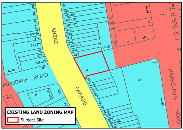
Figure 3: Existing zoning map for Meeks Street Plaza
The site is proposed to be zoned RE1 Public Recreation in accordance with the Actions of the Kensington and Kingsford Town Centre Planning Strategy.
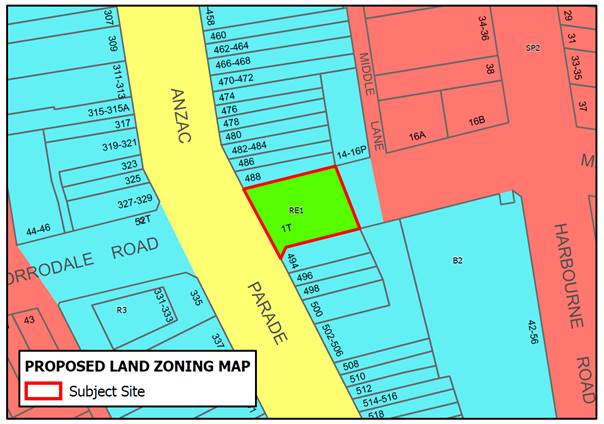
Figure 4: Proposed zoning map for Meeks Street Plaza
No other map changes are proposed.
· 17R Pine Avenue, Little Bay
The 17R Pine Avenue, Little Bay is an approx. 760m2 site on the southern side of Pine Avenue, Little Bay and is owned by Randwick City Council. The site has frontages to both Pine Avenue and McMaster Place, Little Bay and currently functions as public open space providing a through site link between Pine Avenue and McMaster Place, Little Bay. To the south of the site is the Coast Hospital Memorial Park, also zoned RE1 Public Recreation.
|
Figure 5. Ariel view of existing site at 17R Pine Avenue, Little Bay |
Figure 6. Existing view of 17R Pine Avenue, Little Bay looking south from Pine Avenue |
The subject site is within the Prince Henry Site, which is listed on the NSW State Heritage Register. The site is also listed as a local heritage item under RLEP 2012 (Item 175 Prince Henry Site and Coast Hospital Heritage Conservation Area and their settings, significant built and landscape components, including historic precinct (comprising significant buildings, structures and landscape features such as ornamental plantings, retaining walls, kerbs and significant road alignments) and is located within a heritage conservation area (C6 Prince Henry Hospital Site). No change is proposed to the site’s heritage status.
The site is currently zoned R1 General Residential zone consistent with the surrounding land in the Little Bay (Prince Henry) development as shown in Figure 7 below.
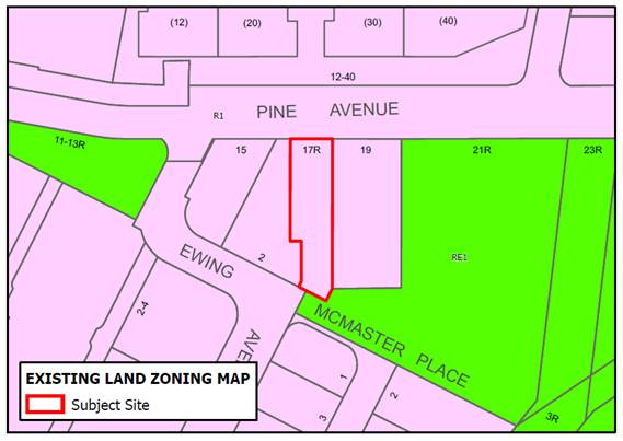
Figure 7: Existing zoning map for 17R Pine Avenue, Little Bay
The site is proposed to be zoned RE1 Public Recreation.
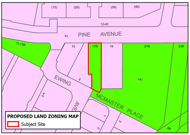
Figure 8: Proposed zoning map for 17R Pine Avenue Little Bay
No other map changes are proposed.
· 5R Young Street, Randwick (part of Newmarket Site
The site (Lot 34 in DP1262464) is located within the Newmarket Site development in Randwick and is used as public open space within the development, including a playground and a number of significant trees (refer Figures 9, 10 & 11 below). The site is approx. 5,000m2 in area and has frontages to Young Street (western frontage) and Yarraman Avenue (northern and eastern boundary), Randwick.
|
Figure 9: Aerial view of site at 5R Young Street, Randwick |
Figure 10: View of existing site from Yarraman Avenue, Randwick looking west |
Figure 11: Inglis Park Playground, Extract from Draft Randwick Open Space & Recreation Needs Study 2020 (Inglis Park Playground in Randwick Source: rydedistrictmums.com.au)
The site occupies a prominent corner location and is visible from various vantage points. The subject site is within Newmarket Site, with land immediately to the west of the site identified as the Struggletown Heritage Conservation Area. The site is also listed as a local heritage item under RLEP 2012 (I292 Newmarket Sale Ring). No change is proposed to the site’s heritage status.
A rezoning proposal for the Newmarket Site was approved 2015 with a new site-specific Development Control Plan and amendments to RLEP 2012. The subject site will be dedicated to Council as part of a Voluntary Planning Agreement. Rezoning the site from R1 General Residential to RE1 Public Recreation will recognise the site and formalise its use as public open space.
The site is currently zoned R1 General Residential zone consistent with the surrounding land in the Newmarket development, Randwick as shown in Figure 12 below.
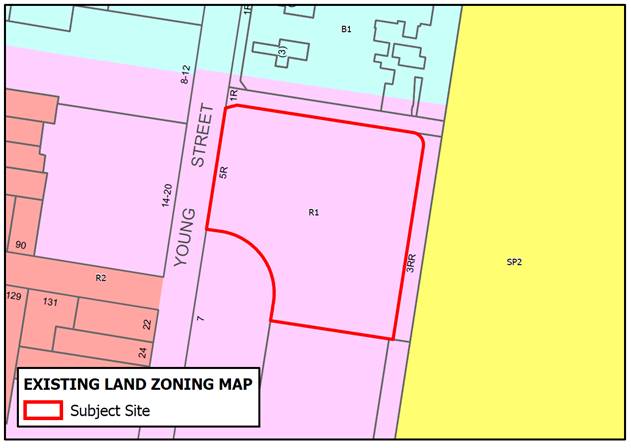
Figure 12: Existing zoning map for 5R Young Street, Randwick
The site is proposed to be zoned RE1 Public Recreation.
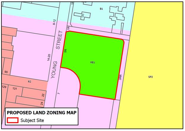
Figure 13: Proposed zoning map for 5R Young Street, Randwick
The current maximum FSR for the site is 0.5:1 as shown in Figure 14 below. This FSR maximum is consistent with the surrounding land in the Newmarket site.
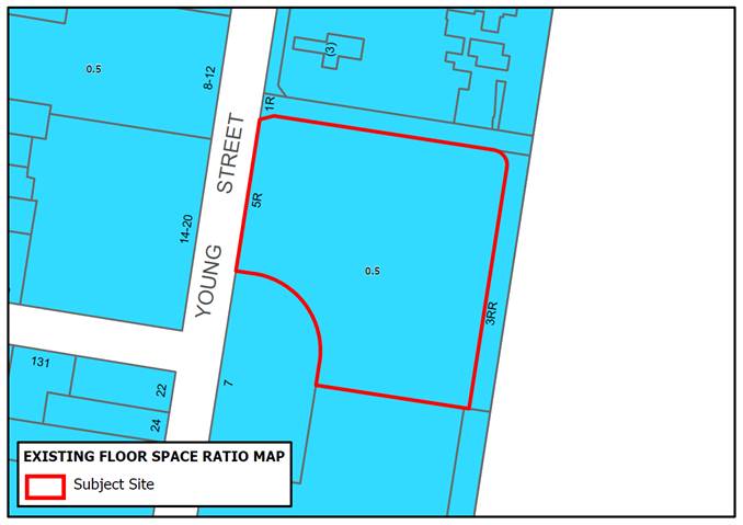
Figure 14: Existing floor space ratio map for 5R Young Street, Randwick
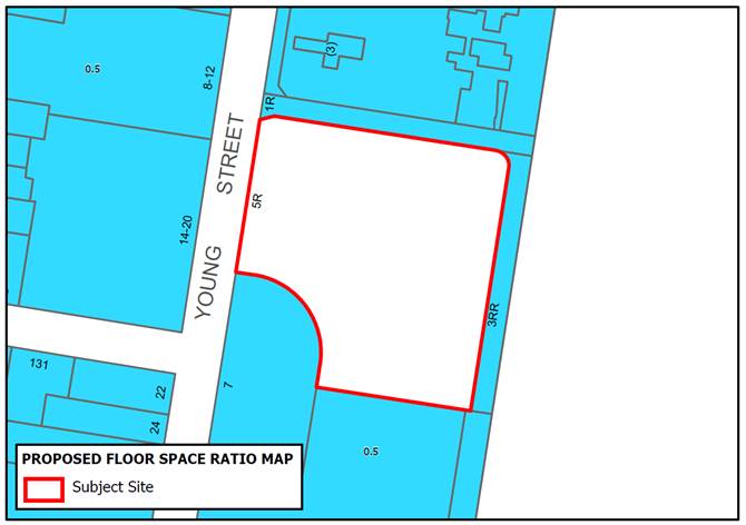
Figure 15: Proposed floor space ratio map for 5R Young Street, Randwick
The current maximum building height for the site is 25m as shown in Figure 16 below.
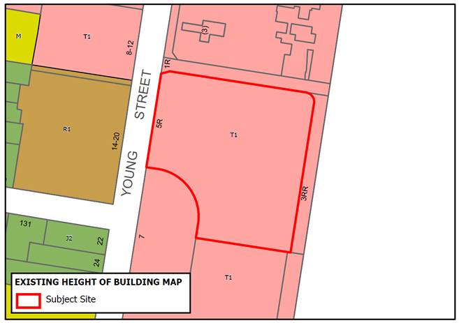
Figure 16: Existing maximum building height map for 5R Young Street, Randwick
The Building Height Map is proposed to be amended for the site to show no maximum building height (refer Figure 17), consistent with all RE1 Public Recreation zoned land.
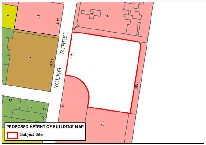
Figure 17: Proposed maximum building height map for 5R Young Street, Randwick
The current minimum lot size for the site is 400sqm as shown in Figure 18 below. This minimum lot size is consistent with the land adjacent to the subject site.
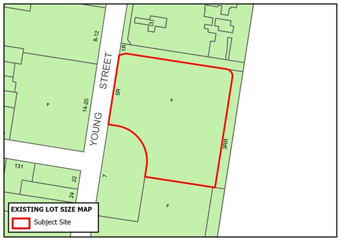
Figure 18: Existing lot size map for 5R Young Street, Randwick
The Lot Size Map is proposed to be amended for the site to show no minimum lot size (refer Figure 19), consistent with all RE1 Public Recreation zoned land.
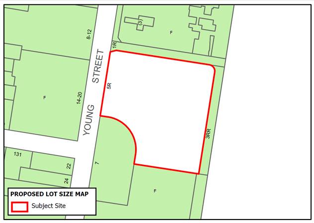
Figure 19: Proposed lot size map for 5R Young Street, Randwick
Clause 6.12 Development requiring the preparation of a development control plan
The existing Clause 6.12 Development requiring the preparation of a development control plan applies to sites with an area of at least 10,000 square metres or sites identified as “DCP required” on the Key Site Map.
The proposal is to modify Clause 6.12 to consider open space impacts of these larger sites to address the connections and capacity of surrounding open space areas as identified in the Open Space and Recreation Needs Study.
Clause 6.12(4) is proposed to be amended to include a new subclause (o) which requires that the development control plan must address:
o) the capacity and connection to existing areas of open space.
This is in addition to the existing requirement that the DCP must consider (c) distribution of land uses, including open space (its function and landscaping) and environment protection areas.
Other matters to be considered in a future DCP amendment
As noted above in relation the Policy Context, a number of the priorities and actions in the strategy documents are more suitable for inclusion in the detailed provisions in the Development Control Plan including:
· Electric vehicle charging stations
The average household in the Eastern Suburbs region drives 29 km/day. A household that switches to an electric vehicle could save over $1,200 in fuel costs, and 800kg in emissions per year. Electricity demand from electric vehicle charging may also increase the viability of solar PV and cogeneration systems, by providing further opportunity for emissions reductions and cost savings. Electric vehicles require charging infrastructure in order to make them practical for day-to-day use. This includes fast charging stations in the public domain and convenient access to power outlets from residential parking spaces. Therefore, in order to encourage the uptake of electric vehicles across the region, there needs to be a regional network of charging stations to make them viable.
Council will continue to rollout public electric charging stations throughout the LGA and will investigate provisions in the DCP review to require all new multi-unit residential and mixed use development to provide charging stations in their car parking areas. It is noted that the current DCP Chapter Kensington and Kingsford Town Centre includes a provision requiring proposals to provide one (1) electric vehicle changing point for every five (5) car parking spaces.
· Solar Panels
According to data from the Australian PV Institute (Dec 2020), 13.5% of properties within Randwick City are powered by solar. This includes over 3,000 PV installations on residential properties. These facilities are offsetting more than 16,000 tonnes of carbon dioxide per year. Council is encouraging existing developments to install solar panels through Council’s Community Sustainable Investment Program which is offering rebates up to $2,000 to install rooftop solar systems. The review of Council’s DCP will investigate promoting rooftop solar panels into new developments.
· Deep Soil Planting
To increase tree canopy within the Randwick City in line with the Environment Strategy target, new development sites need to provide adequate deep soil provision to enable tree growth. The review of Councils DCP will investigate increasing the requirements for deep soil provisions for future development, including requiring developments to increase tree canopy by identifying number of trees/sites, provisions for planting in landscape areas, and identifying and improving open space connections and corridors.
· Urban Heat Island
The Eastern Suburbs of Sydney is going to become hotter through the impacts of climate change, with the number of extreme hot days over 35 degrees projected to increase.
The impact will be greater in urban areas due to the “heat island effect” as noted above. Mitigating the urban heat-island effect is critical to the health and resilience of the environment and local communities. Increasing tree canopy to provide shade and increasing areas of permeable materials on the development site are two ways in which the heat island effect can be mitigated by new development. The review of Council’s DCP will investigate minimising the impacts of the heat island affect (site impacts and cumulative impacts) for future development.
· Biodiversity Corridor Mapping
The mapping prepared by SSROC, which identifies supporting habitats and supporting areas for future habitat connections, is suitable for inclusion in the DCP rather than including in the Biodiversity (priority habitats) layers in the existing Terrestrial Biodiversity Map associated with clause 6.5 Terrestrial biodiversity of the Randwick LEP. The supporting habitats and supporting areas will be reviewed and considered in the future DCP amendment which will clearly identify these habitat corridors as a matter for consideration in development applications.
Strategic alignment
The relationship with the City Plan is as follows:
|
Outcome/Direction |
Delivery Program actions |
|
Outcome |
1. Leadership in sustainability |
|
Direction |
1a. Council has a long-term vision based on sustainability. |
Resourcing Strategy implications
This Planning Proposal was prepared by the Strategic Planning Team with assistance from Consulting Strategic Planners.
Policy and legislative requirements
The Planning Proposal has been informed by the Environmental Planning and Assessment Act 1979 and the strategies and plans prepared under the Act including the Greater Sydney Commission’s Greater Sydney Region Plan (A Metropolis of Three Cities), Eastern District Plan, State Environmental Planning Policies, Ministerial Directions and Randwick Local Strategic Planning Statement. Council’s strategies and studies include the Randwick Environment Strategy and Open Space and Recreation Needs Study.
The proposed changes to the Terrestrial Biodiversity Mapping are informed by analysis prepared under the Biodiversity Conservation Act 2016 by the Department of Planning, Industry and Environment.
Conclusion
This Resilience Planning Proposal identifies amendments to the provisions of the Randwick Local Environment Plan 2012 to address and encourage sustainable and resilient development in Randwick City.
The proposed changes in this Planning Proposal include amendments to the Aims and Zone Objectives (E2 Environmental Conservation and RE1 Public Recreation), amendments to clauses which strengthen the LEP provisions relating to water sensitive urban design, urban heat island, renewable energy sources, water management and open space connections and access. The Planning Proposal also includes changes to the Land Zoning Maps for a number of sites proposed to be zoned RE1 Public Recreation and the Terrestrial Biodiversity Maps to reflect the updated analysis provided by the Department of Planning, Industry and Environment.
The proposed legislative (LEP) changes address the key outcomes identified in the Environment Strategy and the Open Space and Recreation Need Study within the parameters of the Standard Instrument LEP and will support a more resilient Randwick City. Future amendments to the Randwick DCP will further strengthen the resilience provisions including requirements for electric vehicle charging, solar panels, deep soil planting, urban heat island effect and biodiversity corridors.
The proposed changes to the aims, objectives, land use zones, and local provisions (including mapping) will be incorporated into a Comprehensive Planning Proposal seeking amendments to the RLEP 2012 which is anticipated to be reported to Council in May 2021.
Responsible officer: Bronwyn Englaro, Senior Sustainability Officer; Kerry Longford, Strategic Planning Consultant; Emese Wolf, Environmental Planning Officer
File Reference: F2018/00590