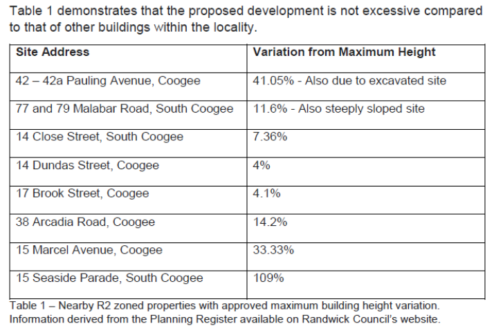
![]()
![]()

Randwick Local Planning Panel (Public) Meeting
Thursday 26 November 2020
 |
|||
 |
|||
![]()
![]()
Randwick Local Planning Panel (Public) Meeting
Thursday 26 November 2020
|
|||
|
|||
Randwick Local Planning Panel (Public) meeting
 |
Randwick Local Planning Panel (Public)
Notice is hereby given that a Randwick Local Planning Panel (Public) meeting
will be held by public teleconferencing via Microsoft Teams on
Thursday, 26 November 2020 at 1pm
Declarations of Pecuniary and Non-Pecuniary Interests
Address of RLPP by Councillors and members of the public
Privacy warning;
In respect to Privacy & Personal Information Protection Act, members of the public are advised that the proceedings of this meeting will be recorded.
Urgent Business
Development Application Reports
D71/20 59 Beach Street, Coogee (DA/637/2019)............. 1
D72/20 9 Carlton Street, Kensington (DA/92/2018/B)..... 67
Kerry Kyriacou
Director City Planning
Randwick Local Planning Panel (Public) meeting
|
Development Application Report No. D71/20
|
|
Subject: 59 Beach Street, Coogee (DA/637/2019) |
|
|
|
|
|
|
|
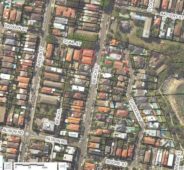
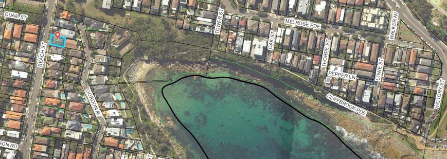
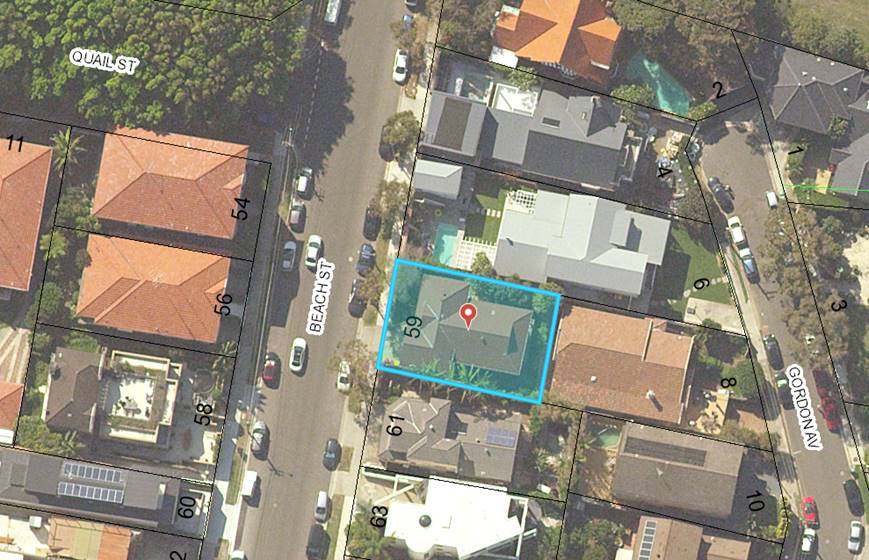
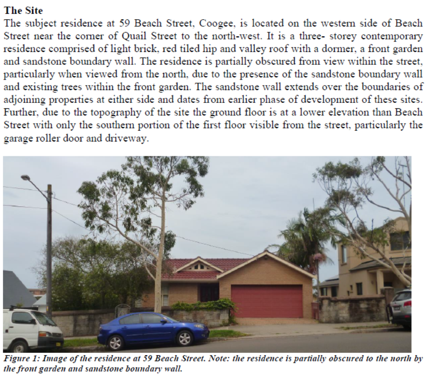
Subject Site |
|
|
|
|
|
Submissions received
Ù North |
|
|
Locality Plan |
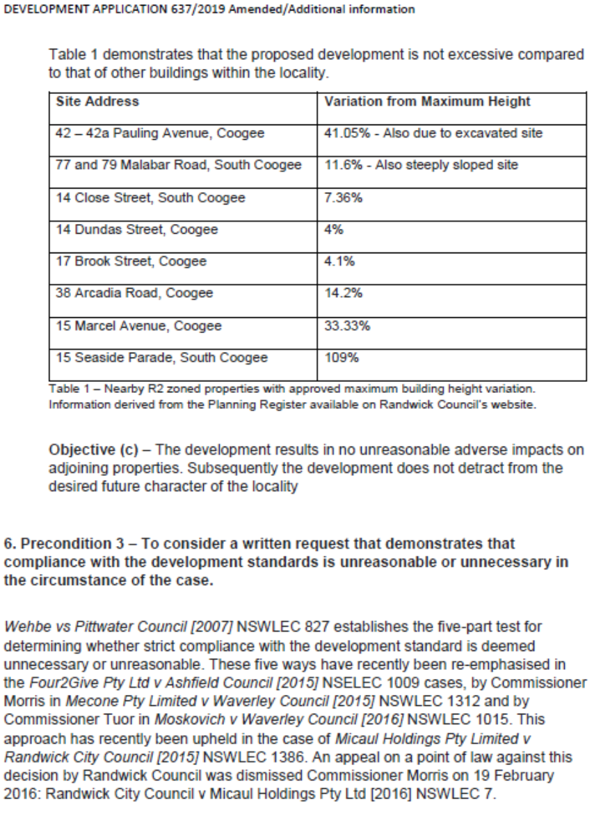
1. Executive summary
The application is referred to the Randwick Local Planning Panel (RLPP) as 16 unique submissions by way of objection were received.
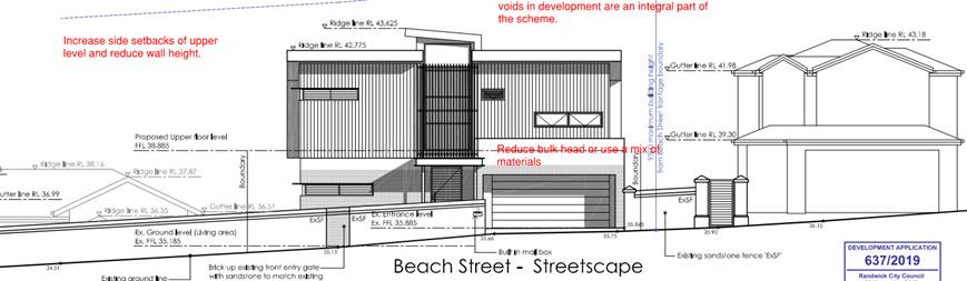
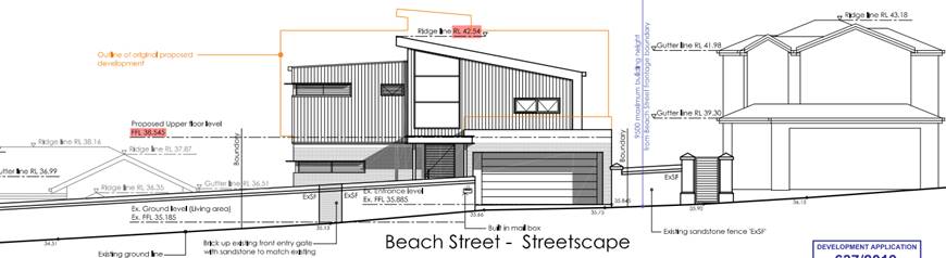
The proposal seeks development consent for alterations and additions to existing dwelling at lower ground, ground and first floor levels seeking an exception to the 9.5m maximum building height standard in the RLEP. The original application was amended on 2 separate occasions with the latest iteration showing a redesign of the proposed upper most level that includes a reduction in overall height from 11.52m down to 9.68m, reduction of external wall heights, increased southern side setback, minor increase in floor area to front and rear upper level and balcony. An amended Clause 4.6, additional view loss assessment information inclusive of additional caged images show three alternate schemes – original, first amendment providing a lower skillion roof and final amendment showing a hipped roof form at the topmost level.
The key issues associated with the proposal relates to whether the Clause 4.6 seeking an exception to the building height standard provides sufficient environmental planning grounds for the height variation, where the adverse impacts on the amenity of neighbouring properties with particular regards to views, visual bulk and overshadowing are acceptable.
In relation to sufficient environmental planning grounds, the pre-existing excavated lower ground level below the street level and forms a characteristic of the locality that has existed for many decades along this side of Beach Street making it difficult to determine natural ground levels. The salient aspect of the lower ground level is that it has not restricted development potential of other properties southward along Beach Street which generally present a 2 storey scale at street level and three storey within the site particularly for development of sites southward along this side of Beach Street. The proposal as amended will be consistent with this established character along Beach Street.
In relation to adverse impacts on neighbours, with particular regard to the acceptability of view loss from apartments across the road at No’s. 54 and 56 Beach Street, a key consideration is whether the applicant has sufficiently established the amended proposal is skillful enough and whether a more skillful design would not achieve a better outcome. In terms of the original proposal and first amended scheme, it was not considered to be skillful as it was considered that the skillion roof form was unnecessary and resulted in a loss of water views over the top of the proposed upper level from apartments within No’s 54 and 56 Beach Street. The 2nd amendment, the subject of assessment, proposes a hipped roof form replacing the skillion roof and providing reduced 2.4m floor to ceiling heights. This scheme retains a more expansive and deeper water view over the top pf the proposed development which is considered of greater value than the views retained from the first amendment which were largely limited to a triangular view of the water across the southern side of the skillion roof and southern side boundary between No. 61 Beach Street from unit 4/56 Beach Street and 3/56 Beach Street.
In relation to visual bulk and overshadowing, the proposed external wall heights do not comply with the RDCP controls and have the potential to result in adverse visual bulk on No. 6 Gordon Avenue whose rear yard adjoins the northern boundary of the subject site. The proposal also results in overshadowing of north facing windows of No. 61 Beach Street which adjoins the southern boundary of the subject site. Despite these adverse impacts, it is considered the impacts are not unreasonable given the development pattern varies southward from the subject site due in large part to these properties being limited to single frontages along Beach Street as opposed to the dual frontages of properties northward of the site starting from No. 6 Gordon Avenue and the east-west orientation of the site combined with the sunken in lower ground levels make the southern neighbours particularly vulnerable to overshadowing.
The proposal is recommended for approval subject to non-standard conditions that require additional privacy screens to the northern and southern sides of the upper level terrace area.
2. Site Description and Locality
The subject site is known as 59 Beach Street and is legally described as Lot 12 in DP 847232. The site is 352m2, is regular in shape, with a slightly skewed front boundary with a 15.24m frontage to Beach Street to the west and a side boundary depth of 23.35m and 22.865m to the north and south respectively.
The site drops from street level along Beach Street by around 3.4m from 35.52 down to RL32.12 a characteristic of sites along this side of Beach Street. The site contains a two storey dwelling with the lower land level sited below street level.
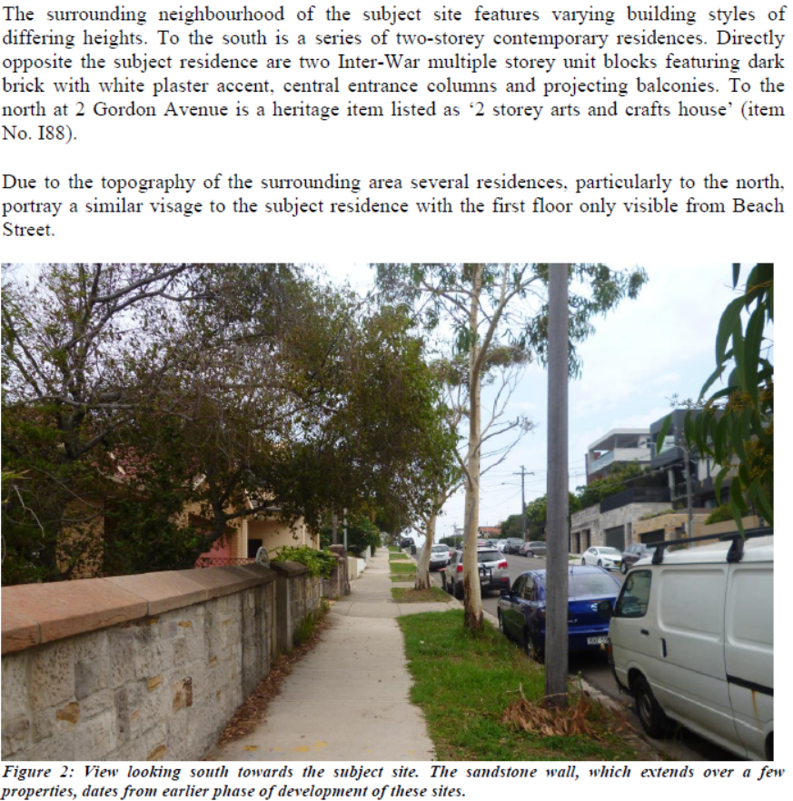
The adjoining site to the north at No. 6 Gordon Avenue, has its rear yard containing terraced rear yard, a swimming pool and attached pergola adjoining the subject site and the site to the south at No. 61 Beach Street, a three storey dwelling on a similar topography with a lower ground level siting below street level, occurs whereby the neighbouring dwelling presents as a two storey dwelling at street level with a lower ground level that is below and behind street level. This is characteristic of other properties along this side of Beach Street.
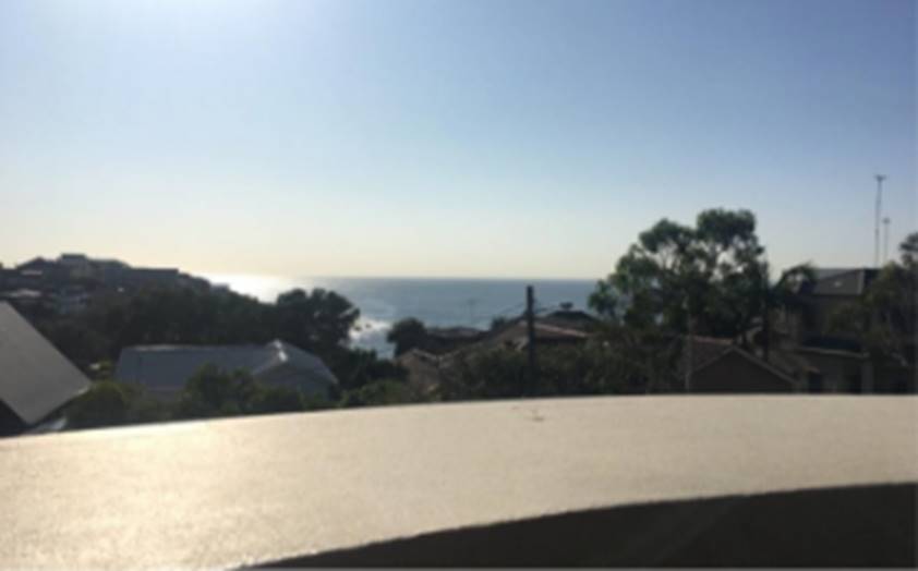
 Aerial
view of subject site and wider view eastward to Gordon’s Bay
Aerial
view of subject site and wider view eastward to Gordon’s Bay
Aerial view of subject site and neighbouring
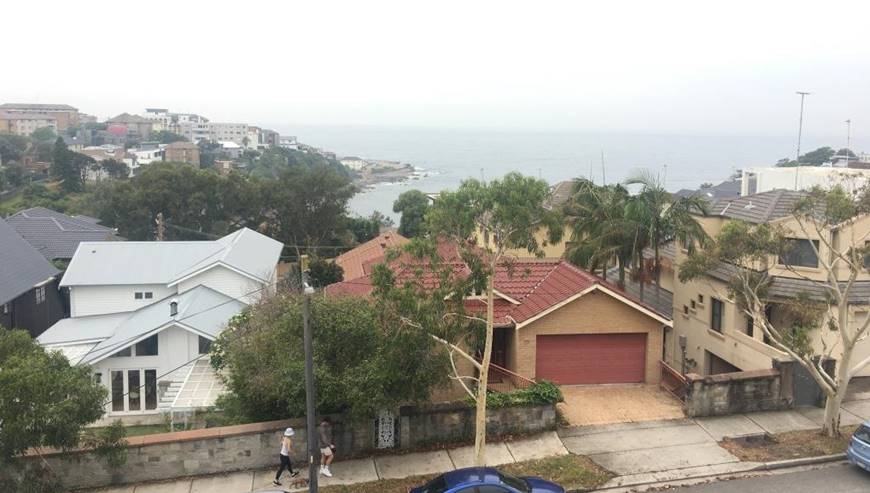
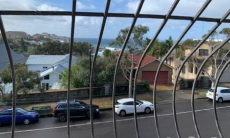
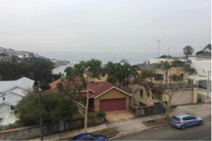
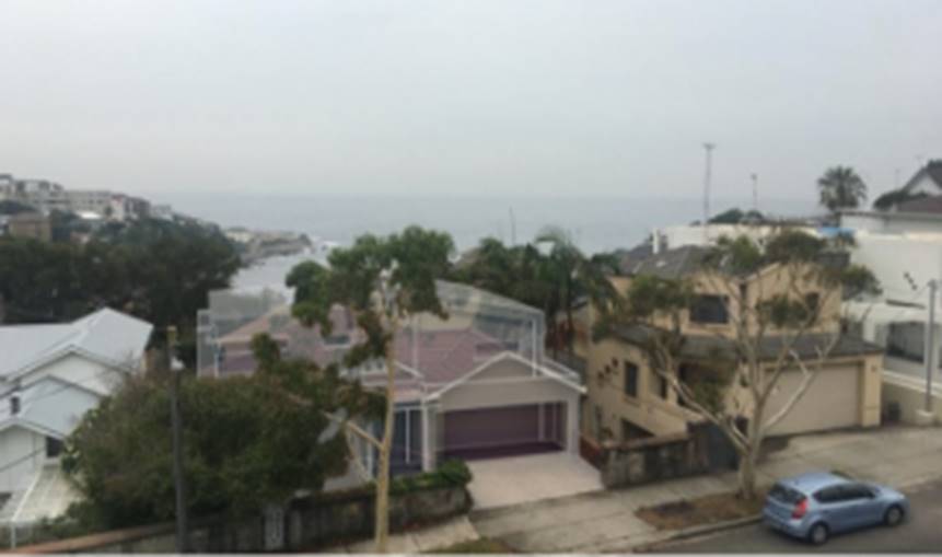
Photo 1: Street view of subject site containing cream brick dwelling with red tiled roof, at left, white themed two storey dwelling at No. 6 Gordon Avenue and at right three storey dwelling at No. 61 Beach Street.
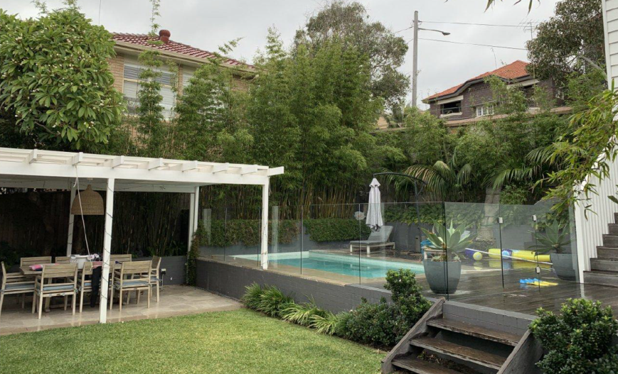
Photo 2: view from rear yard of No. 6 Gordon Avenue looking towards northern elevation of existing dwelling.
3. Relevant history
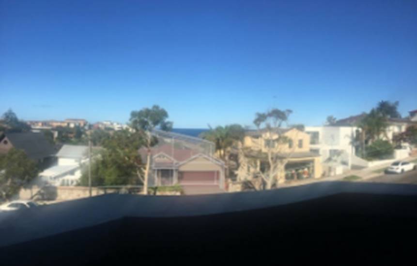
Figures below show the iterations of the proposed development from the original schem, to the 2nd amended scheme.
1. Orignal propsoal:
Comment: The original skillion was considered to dominate the existing dwelilng, and the streetscape character. In response to an RFI, the applicant submitted the first amended scheme shown below.
2. 1st Amended scheme with a reduced upper level additon, and 1st amended proposal:
A view loss assessment from the units opposite at Nos. 54 and 56 Beach Street accompanied the amended scheme. Notification was carried out and further submissions were received and addressed in the key issues section of this report.
After a more detailed analysis of the view loss assessment from apartments opposite namely Unit 4/56 Beach Street (inclusive of other units), it was considered the proposed skillion roof, shown in Photomontage A below, and in comparison with a flat roof with 2.7m minimum floor to ceiling heights (shown in Photomontage B) and a hipped roof form with 2.4m floor to ceiling heights (shown in Photomontage C) resulted in unnecessary view loss. The applicant was advised that a hipped roof form was most representative of a skillful design as it retained most views and allowed a reasonable level of amenity for the site resulting in the 2n set of amended plans being submitted and the subject of assessment of this DA – see point 3 elevation further below.
Photomontage A: showing impact of 1st set of amended scheme (point 2 above), which reduced size of the upper level addition and skillion roof (pint 2 above) as viewed from the balcony of No. 4/56 Beach Street.
Photomontage B: Flat roof form (reflective of 1st amendments above) with 2.7m minimum floor to ceiling heights under the RDCP.
Photomontage C: Hipped roof with a 2.4m minimum floor to ceiling heights the minimum under the BCA reflective of 2nd amendment shown below and subject of assessment.
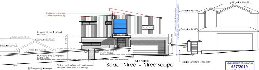
3. 2nd amended proposal, subject of assessment, (reflective of the photomontage B above replaces the skillion roof with a hipped roof shown in street elevation form below.
4. Proposal
The proposal seeks development consent for alterations and additions to existing dwelling at lower ground, ground and new upper level (variation to height control). The particulars are as follows:
Lower ground level:
· 2 bedrooms
· Storage and
· Family room
· Decks and verandahs
Ground street level:
· Double garage
· Master bedroom and ensuite
· Small retreat
· Rear blaocny
Upper floor:
· Kitchen and dining area
· Living room
· Rear balcony
5. Notification
The owners of adjoining and likely affected neighbouring properties were notified of the proposed development in accordance with the Randwick Comprehensive DCP 2013. The following submissions were received as a result of the notification process:
· 1-4/56 Beach Street (34 Patton Street
· 2/56 Beach Street
· 1/54 Beach Street
· 3/54 Beach Street
· 4/54 beach Street
· 5/54 beach Street
· 6/54 beach Street
· 7/54 Beach Street
· 6 Gordon Avenue x 2
· 8 Gordon Avenue
· Strata Secretary for 56 Beach Street
|
Issue |
Comment |
|
The proposal results in additional overshadowing to apartment 2/56 Beach Street and Beach Street |
The application has been amended and overshadowing to neighbouring properties is considered acceptable. |
|
The proposal results in the loss of sunrise view. |
The degree to which sunrise views should be protected is limited given that ultimately, they vary throughout the year which means that some will be retained and also it is considered that the proposed development as amended has a size and scale that integrates with the existing streetscape. |
|
The proposal is out of scale and not in keeping with the surrounding properties and streetscape. |
Noted, the development has been amended reducing its scale such that it is considered to be generally consistent with the streetscape character. |
|
The proposed height is excessive at 11.52m and increase in massing on either side of the roof results in significant view loss of Gordons Bay. |
See view loss assessment in the key issues section of this report. In short, the proposal has been amended reducing the height and lessen the extent of view loss from properties in the vicinity of the site. |
|
Request height poles be installed to determine loss of views. |
Height poles were not installed as the applicant has submitted photomontages showing the proposed development from various properties considered susceptible to view loss. The accuracy of photomontages has been verified. |
|
Having regard to the context of the site conditions the proposed three storey scale will be overpowering from the rear yard and living room level of No. 6 Gordon Avenue. |
Noted, the proposal has been amended with reduced height and increased setback from the side boundary adjoining the swimming pool areas and rear yard of No. 6 Gordon Avenue such that it is not considered that on balance, the proposed development (as amended) responds appropriately to the topography of the site and the surrounding area and will not result in unreasonable adverse visual amenity impacts on this neighbours rear yard and living room level. |
|
The unique setting of the properties to the north of the site particularly No. 6 Gordon Avenue, which have long depths with dual access to Gordon Avenue represent quality landmarks in the area, will the proposals excessive size and scale will adversely impact the setting of these northern neighbouring properties. |
Noted, the application has been amended reducing its bulk and scale. The amended proposal is considered to have an acceptable level of visual impacts with regards to the visual setting of the neighbouring properties and the area. |
|
The existing structure is already too high and there is a perception of adverse visual privacy impacts on the amenity within our rear yard and swimming pool areas |
Noted, the existing building contains very large north facing window at the existing ground level, however the proposal will contain smaller window dimensions and appropriate conditions are applied in order to ensure reasonable visual privacy of the neighbours rear yard including the swimming pool area and habitable room windows. |
|
The size and location of balconies has the potential to result in adverse noise and visual privacy impacts. |
The noise from balconies associated with residential uses is not anticipated as being inordinate. In relation to visual privacy, conditions are included to restrict sightlines from the balcony into the neighbouring properties. |
|
It is our understanding that when we bought the property at No. 6 Gordon Avenue, that a three storey building and anything exceeding 8m would not be allowed. |
Each application is assessed on its merits and there is no absolute prohibition on proposals without carrying out a merit assessment. The original development was considered inappropriate in terms of its impact on the streetscape and neighboring properties and was amended on 2 occasions with the second considered to be acceptable having regard to the relevant planning polices applicable to the site. |
|
Opposed to the removal of trees along the northern side of the subject site as they provide a buffer from visual and acoustic privacy as well as visual bulk for No. 6 Gordon Avenue. |
The trees within the subject site are not covered under Part B5 of the RDCP and may be removed without development consent. It is noted that the application does not indicate that these trees will be removed.
It is noted bamboo is located within the neighbour’s site which provides an existing visual amenity buffer and privacy. The proposal will result in different privacy impacts however these have been adequately addressed with the inclusion of conditions for full length privacy screens to sides of balconies and treatment to windows facing the rear yard of No. 6 Gordon Avenue. |
|
The submitted documents do not provide a proper and reliable view assessment of actual vies enjoyed from each affected property. A detailed view analysis needs to be prepared in accordance with the practice notes established by the NSW Land and Environment Court (LEC). |
The submitted view loss assessment carries out an assessment of the most affected units of the scheme and a view loss assessment is carried out in the key issues section of this report. It is also noted that the applicant has provided documentation pertaining to the analysis using existing photos taken by the assessment officer, use of survey data of existing elements and establish camera location to RL levels and use of established software – Camera Match Utility. |
|
The DA plans do not demonstrate the maximum 9.5m height plane to the underside of the lower level building slab and clearly show the encroachments above the maximum building height standard in the RLEP and should be corrected to clearly show the maximum building height and encroachments.
Any additional structures such as solar heating units, ducting and air conditioning units or plant enclosures must be added to the plans and considered in the Clause 4.6 assessment. |
The plans are adequately dimensioned showing RL levels of both the proposed and existing levels within the site. Use of the survey RL levels and proposed development as amended has been provide. An accurate calculation of the 9.5m height plane measured to the existing ground level at RL32.05 floor level of the lower ground level as 9.7m which equates to the measured to the underside of the slab at lower ground level. The purpose of the Clause 4.6 is to assess whether it is unreasonable or unnecessary to strictly apply the standard having regard sufficient environmental planning grounds and the objectives of the standard and the zone. See assessment in Section 7 of this report and other relevant sections.
The plans appear to show all relevant structures on the roof. |
|
Units 3/54 Beach Street view loss only captures view from balcony and not from different points within the adjoining rooms and along the balcony.
|
The photo is the most impacted part of this unit. It is also noted that this unit is connected to a bedroom however it is acknowledged that the occupants use this area for meals and provides a high level of amenity. The photo on left shows that the views form this unit are of the horizon water views and interfacing land and wash obstructed by trees in the background. In combination with the location of the unit and height of other structures along the development side of the street, it is considered that for this view to be retained it would require a substantially reduced scale that would reduce the development potential of the site below that which currently exists on properties south of the site along Beach Street. |
|
The subject DA should quantity which areas have been included in the GFA and calculated FSR |
The FSR is calculated as 0.55:1 which is well below the maximum 0.75:1 permitted under the RLEP. |
|
The overshadowing diagrams are unacceptable. |
The overshadowing diagrams are acceptable. The solar access retained to No. 61 Beach Street are acceptable. The upper level southern side setback has been increased to 1.8m and complies with the minimum setback control in the RDCP. It is also noted that the southern neighbour is particularly vulnerable to overshadowing due to the existing pattern of development in the area on east-west subdivision pattern. |
|
The notion that the rear boundary fence is located incorrectly is not agreed to by the owners of No. 8 Gordon Avenue and the proposed rectification of the rear boundary fence location is objected to and do not consent to any condition that allows its re-positioning. It is noted that No. 8 has a benefit of a right of footway along the rear registered in 1995. Council has not right to impose any condition in approved the DA or otherwise which affects No. 8 Gordon from using he right of footway in accordance with its terms. |
Noted and a suitable advisory condition is included. |
5.1. Renotification
Renotificaiton of the 1st set of amended plans was carried out due to the increase in depth of the first floor level at the rear from 25 May 2020 to 3 June 2020. The following 3 submissions were received as a result of this notifiaiotn process:
· Town Planner submission on behalf of 54 Beach Street
· Town Planner submission on behalf of 56 Beach Street
· Town Planner submission on behalf of 6 Gordon Avenue
· 6 Gordon Avenue (issues are simulatnaously addressed in the notification section above)
|
Issue |
Comment |
|
The proposal (1st set of amended plans) results in view loss from apartments in 54 Beach Street |
Noted, see key issues section of this report. It is noted that unit 4 is the most impacted apartment with regards to views and that further amendments have been made removing the skillion roof retaining horizon views of the water over the proposed development. The headland interfacing water views is lost, it is not considered unreasonable in the context of the site and surrounding area. |
|
The proposal results in a 3 storey building with a height of 10.7m exceeding the 9.5m maximum height standard which is inconsistent with R2 zone objectives, the objectives of the height of buildings standard in the RLEP and Section 3.2 in the RDCP. |
See relevant key issues section of this report and Clause 4.6 assessment.
Note: Section 3.2 provisions in the RDCP relate to building heigh. The proposal as further amended removing the skillion roof reducing the height is considered to satisfies the associated objectives of the RDCP and the RLEP. |
|
The neighbouring development at No. 61 Beach Street is a 2 storey development not a 3 storey development as indicated in the SEE and does not step down to 2-storeys at the rear. |
No. 61 Beach Street form street level presents as a 2 storey building however within the site is three storeys that does step down to 2-storeys as approved and constructed under DA/1229/2001. It is also noted that the proposed upper level addition is similarly located at the front of the site and has a footprint that is less than the ground level below providing a slightly reduced step down to the rear in comparison with No. 61 Beach Street. The proposal also increases the rear setback from the existing rear setback. |
|
The view for unit 3/54 and 4/54 Beach Street would almost completely obliterate the interfacing land and water view. |
Acknowledged, however it is not considered reasonable to retain this view due to the location and level of the affected unit. It is noted that horizon water views will be retained from these units. |
|
The 8m maximum wall height RDCP control should not be applied to the site as it is not steeply sloping but rather has been subject to extensive excavation which results in the site having a relatively flat topography. |
The site is considered to be steeply sloping as contours demonstrate at least a 3m drop from street level down to the site in very short distance. Notwithstanding, it is acknowledged that the proposed external wall heights exceed the 8m maximum whereby a merit assessment against the associated objectives is provided in the key issues section of this report. In short, it is considered that the proposed development responds appropriately to the site conditions and the scale of development in the area and limiting the development to a two storey scale within the site and one storey along the streetscape is unreasonable given the size and scale of development in the area. |
|
The proposal will result in jarring transition in height that is not reflective of the natural cross fall of the street which creates unreasonable visual impact and inconsistent with the existing character of the street. |
The proposal as amended has a scale that is considered to be consistent with the existing streetscape character having regard to properties southward of the site sharing similar site characteristics in terms of land size, topographies and single frontages to Beach Street where they present as two storey built forms. Conversely, whilst the northern neighbour’s land also shared topographical similarities it is evident that as a result of the dual frontages that it presents as the rear of the site from Beach Street containing smaller scale of development. In this respect, the difference in scales between the proposed development and the scale of development at No. 6 Gordon Avenue is expected. |
The second set of amended plans were not required to be re-notified due to the amended scheme not being considered to have any appreciable advese impacts when considered against the original and 1st amended scheme.
6. Relevant Environment Planning Instruments
6.1. SEPP (Vegetation in Non-rural Areas) 2017
There are no existing trees on site sought to be removed.
6.2. SEPP 55 – Remediation of Land
The porposal matinains the exisitng use on site at ground level and proposed works are not likley to result in any exposure to contamination with the first floor having been extensively utilised for residential purposes.
6.3. Randwick Local Environmental Plan 2012 (LEP)
The site is zoned R2 under Randwick Local Environmental Plan 2012 and the proposal is permissible with consent.
The following development standards in the RLEP 2012 apply to the proposal:
|
Clause |
Development Standard |
Proposal |
Compliance (Yes/No) |
|
Cl 4.4: Floor space ratio (max) |
0.75:1 (352sqm site area – see Clause 4.4(2a) of RLEP. |
0.55:1 (excludes top stair level and voids, includes excess garage space and predominately enclose lower ground level deck area to laundry. |
Yes |
|
Cl 4.3: Building height (max) |
9.5m |
Final amendment 9.70m (RL41.60-RL31.90) = 2.1% variation. 1st amendment: 10.64m (42.54/12%) Original: 11.725m (43.625/23.42%)
|
No see sought Clause 4.6 exception to development standard in section below and copy of Clause 4.6 in Appendix 2. |
6.3.1. Clause 4.6 - Exceptions to development standards
The non-compliance with the building height development standard is discussed in section 7 below.
6.3.2. Clause 5.10 - Heritage conservation
See referral Heritage Planner comments in Appendix 1 of this report. No objections to the proposal on heritage grounds pursuant to the objectives and consideration required under Clause 5.10 of the RLEP for Heritage Conservation.
6.3.3. Clause 6.7 Foreshore scenic protection area
The proposed develpoment is considered to satisfy the relevant objectives for the Foreshore scenic protection area in that the reduced built form at first floor level is less dominant and more consistent with the scale of first floor levels above street level on other sites in the area ntoably those located southward o the site at No. 61 and 63 Beach Street, ensuring the devlepoment is appropriate for the location and does not detract form the scenic qualities of the coast. Th colours and materials used will also be consistent with the objectives in Section C1 of the RDCP.
7. Clause 4.6 exception to a development standard
The proposal seeks to vary the following development standard contained within the Randwick Local Environmental Plan 2012 (RLEP 2012):
|
Clause |
Development Standard |
Proposal
|
Proposed variation
|
Proposed variation (%) |
|
Cl 4.3: Building height (max) |
9.5m |
9.7m (RL41.60 at centre ridge measured to RL31.92 which is taken as 150mm below 31.90) |
0.2m |
2.1% |
Clause 4.6 of RLEP 2012: Exception to a Development Standard relevantly states:
3. Development consent must not be granted for development that contravenes a development standard unless the consent authority has considered a written request from the applicant that seeks to justify the contravention of the development standard by demonstrating:
(a) that compliance with the development standard is unreasonable or unnecessary in the circumstances of the case, and
(b) that there are sufficient environmental planning grounds to justify contravening the development standard.
4. Development consent must not be granted for development that contravenes a development standard unless:
(a) the consent authority is satisfied that:
(i) the applicant’s written request has adequately addressed the matters required to be demonstrated by subclause (3), and
(ii) the proposed development will be in the public interest because it is consistent with the objectives of the particular standard and the objectives for development within the zone in which the development is proposed to be carried out, and
(b) the concurrence of the Secretary has been obtained.
In Initial Action Pty Ltd v Woollahra Municipal Council [2018] NSWLEC 118, Preston CJ summarised the matters in Clause 4.6 (4) that must be addressed before consent can be granted to a development that contravenes a development standard.
1. The applicant’s written request has adequately demonstrated that compliance with the development standard is unreasonable or unnecessary in the circumstances of the case
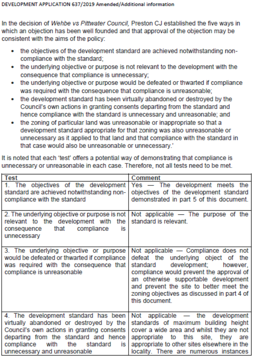
Chief Justice Preston in Initial Action Pty Ltd v Woollahra Municipal Council [2018] NSWLEC 118 reinforces his previous decision In Wehbe v Pittwater Council [2007] NSWLEC 827 where he identified five commonly invoked ways of establishing that compliance with a development standard is unreasonable or unnecessary in the circumstances of the case. The most common is to demonstrate that the objectives of the development standard are achieved notwithstanding non-compliance with the standard.
2. The applicant’s written request has adequately demonstrated that there are sufficient environmental planning grounds to justify contravening the development standard.
Chief Justice Preston in Initial Action Pty Ltd v Woollahra Municipal Council [2018] NSWLEC 118 reinforces the previous decision in Four2Five Pty Ltd v Ashfield Council [2015] NSWLEC 90 regarding how to determine whether ‘the applicant’s written request has adequately demonstrated that there are sufficient environmental planning grounds to justify contravening the development standard’.
The grounds relied on by the applicant in their written request must be “environmental planning grounds” by their nature. Chief Justice Preston at [23] notes the adjectival phrase “environmental planning” is not defined, but would refer to grounds that relate to the subject matter, scope and purpose of the EPA Act, including the objects in s1.3 of the EPA Act.
Chief Justice Preston at [24] notes that there here are two respects in which the written request needs to be “sufficient”.
1. The written request must focus on the aspect or element of the development that contravenes the development standard, not the development as a whole (i.e. The written request must justify the contravention of the development standard, not simply promote the benefits of carrying out the development as a whole); and
2. The written request must demonstrate that there are sufficient environmental planning grounds to justify contravening the development standard. In Four2Five Pty Ltd v Ashfield Council [2015] NSWLEC 90 at [31] Judge Pain confirmed that the term ‘sufficient’ did not suggest a low bar, rather on the contrary, the written report must address sufficient environmental planning grounds to satisfy the consent authority.
3. The proposed development will be in the public interest because it is consistent with the objectives of the particular standard and the objectives for development within the zone in which the development is proposed to be carried out.
Chief Justice Preston in Initial Action Pty Ltd v Woollahra Municipal Council [2018] NSWLEC 118 at [27] notes that the matter in cl 4.6(4)(a)(ii), with which the consent authority must be satisfied, is not merely that the proposed development will be in the public interest but that it will be in the public interest because it is consistent with the objectives of the development standard and the objectives for development of the zone in which the development is proposed to be carried out.
It is the proposed development’s consistency with the objectives of the development standard and the objectives of the zone that make the proposed development in the public interest.
If the proposed development is inconsistent with either the objectives of the development standard or the objectives of the zone or both, the consent authority, cannot be satisfied that the development will be in the public interest for the purposes of cl 4.6(4)(a)(ii).
4. The concurrence of the Secretary has been obtained.
Chief Justice Preston in Initial Action Pty Ltd v Woollahra Municipal Council [2018] NSWLEC 118 at [28] notes that the other precondition in cl 4.6(4) that must be satisfied before consent can be granted is whether the concurrence of the Secretary has been obtained (cl 4.6(4)(b)). In accordance with Clause 4.6 (5), in deciding whether to grant concurrence, the Secretary must consider:
(a) whether contravention of the development standard raises any matter of significance for state or regional environmental planning, and
(b) the public benefit of maintaining the development standard
Under clause 64 of the Environmental Planning and Assessment Regulation 2000, the Secretary has given written notice dated 21 February 2018, attached to the Planning Circular PS 18-003 issued on 21 February 2018, to each consent authority, that it may assume the Secretary’s concurrence for exceptions to development standards in respect of applications made under cl 4.6 (subject to the conditions in the table in the notice).
The approach to determining a clause 4.6 request as summarised by Preston CJ in Initial Action Pty Ltd v Woollahra Municipal Council [2018] NSWLEC 118, has been used in the following assessment of whether the matters in Clause 4.6(4) have been satisfied for each contravention of a development standard.
7.1. Exception to the Building Height development standard (Clause 4.3)
The applicant’s written justification for the departure from the Building Heigh standard is contained in Appendix 2.
1. Has the applicant’s written request adequately demonstrated that compliance with the development standard is unreasonable or unnecessary in the circumstances of the case?
The applicant’s written request seeks to justify the contravention of the building height development standard by demonstrating that compliance is unreasonable or unnecessary in the circumstances of the case because the relevant objectives of the standard are still achieved.
The objectives of the building height standard are set out in Clause 4.4 (1) of RLEP 2012. The applicant has addressed each of the objectives as follows:
(a) to ensure that the size and scale of development is compatible with the desired future character of the locality
The applicant’s written justification demonstrates that this objective is satisfied by noting that
Objective (a) – The subject site is situated within a locality that has a high demand for high quality accommodation and a growing population. By demolishing a portion of the existing structure and undertaking alterations and additions, the quality of the dwelling on site is upgraded whilst respecting the low-density desired future character of the locality with its design which is commensurate in scale and architectural style with others in the streetscape.
The floor space ratio and building height development standards together set the parameters for the scale and density of development and its resultant impact on the streetscape and surrounding developments. The floor space ratio of the proposal is substantially below the permissible maximum and the proposed additions are of a reasonable scale, thus no inappropriate bulk is produced.
(b) to ensure that development is compatible with the scale and character of contributory buildings in a conservation area or near a heritage item,
The applicant’s written justification demonstrates that this objective is satisfied by noting that
Objective (b) – Whilst the development site has a number of heritage items and contributory buildings within its locality, there is substantial separation between the site and these significant properties which mitigates any potential impact. Nonetheless, the proposal is commensurate in scale and character with its surroundings, allowing it to lie subservient in the streetscape and promoting the heritage buildings to dominate.
(c) to ensure that development does not adversely impact on the amenity of adjoining and neighbouring land in terms of visual bulk, loss of privacy, overshadowing and views.
The applicant’s written justification demonstrates that this objective is satisfied by noting that:
Objective (c) – The development results in no unreasonable adverse impacts on adjoining properties. Subsequently the development does not detract from the desired future character of the locality.
Assessing officer’s comments: The applicant’s written request has adequately assessed that compliance with the building height development standard is unreasonable or unnecessary in the circumstances of the case. Particular regard is made to the reduced first floor scale which has resulted in a broader water view that adds value to the view rather than the original or amended scheme which retained views of the water predominately across the southern side of the site only.
2. Has the applicant’s written request adequately demonstrated that there are sufficient environmental planning grounds to justify contravening the development standard?
The applicant’s written request seeks to demonstrate that there are sufficient environmental planning grounds to justify contravening the building height development standard as follows:
· The development is compatible with the zone objective.
· The proposed renovated dwelling house will continue to provide for the housing needs to the community within a low-density residential environment.
· It recognises the desirable elements of the existing streetscape and built form by proposing a contemporary renovation to the existing dwelling house of a height, bulk and scale commensurate with emerging contemporary built forms in the immediate locality, in a manner that will contribute to the desired future character of the area.
· Measures incorporated into the proposed alterations and additions will protect and improve the amenity of residents beyond that associated with the existing dwelling house on the site.
· The variation to the maximum building height does not render the development incompatible with the zone objectives, in accordance with the approach of the former Chief Judge, Justice Pearlman in Schaffer Corporation v Hawkesbury City Council (1992) 77 LGRA 21, in Paragraph [27]: ‘The guiding principle, then, is that a development will be generally consistent with the objectives, if it is not antipathetic to them. It is not necessary to show that the development promotes or is ancillary to those objectives, nor even that it is compatible.’
· The architectural plans prepared by Edifice Design, dated 27 October 2020 submitted with the Development Application at 59 Beach Street, Coogee for “alterations and additions to existing dwelling at lower ground, ground and first floor levels” indicate that the proposed development has a maximum height of 9.7m for a minor portion of the pitched roof, resulting in a 2.1% variation to the development standard and non-compliance of 0.2m. When measured from the existing pre-excavated site terrain, the entire development is lower to the prescribed height limit. The minor portion of the building which exceeds 9.5m is a modest, relatively flat 4 degree pitched roof and does not result in any discernible view loss, bulk, overshadowing or other impact for the adjoining neighbours and surrounding locality.
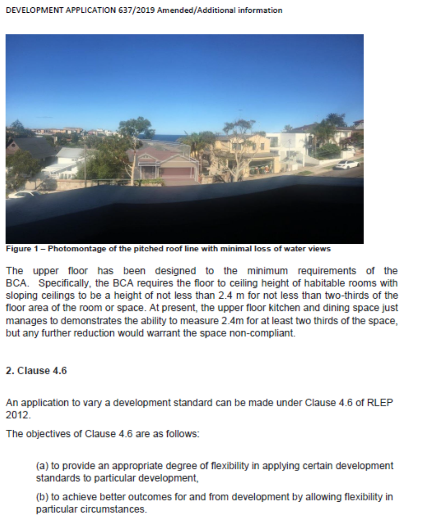
· The upper floor has been designed to the minimum requirements of the BCA. Specifically, the BCA requires the floor to ceiling height of habitable rooms with sloping ceilings to be a height of not less than 2.4 m for not less than two-thirds of the floor area of the room or space. At present, the upper floor kitchen and dining space just manages to demonstrate the ability to measure 2.4m for at least two thirds of the space, but any further reduction would warrant the space non-compliant.
Assessing officer’s comment: The environmental planning grounds provided by the applicant focus on elements that are specific to the site that is the pre-existing excavated land levels set below street level. This is characteristic of the sites further south along Beach Street which provide for two storey scales from street level despite the height exceeding the standard when measured from the excavated lower land levels behind.
The amended design also reduces floor to ceiling heights down to 2.4m which is the minimum height for habitable living spaces and amenity under the BCA and has sought to ensure a skillful design in retaining views from apartments located on the opposite side of the street at No. 54 and 56 Beach Street.
In conclusion, the applicant’s written request has adequately demonstrated that there are sufficient environmental planning grounds to justify contravening the development standard. The height exceedance is a result of pre-existing excavated land levels and the proposal has been designed appropriately.
3. Will the proposed development be in the public interest because it is consistent with the objectives of the particular standard and the objectives for development within the zone in which the development is proposed to be carried out?
To determine whether the proposal will be in the public interest, an assessment against the objectives of the Height of Buildings standard and R2 zone is provided below:
Assessment against objectives of Height of Buildings standard
For the reasons outlined in the applicant’s written request, the development is consistent with the objectives of the building height standard.
(a) to ensure that the size and scale of development is compatible with the desired future character of the locality,
Assessing officer’s comment: The character of the locality is established for sites southward along Beach Street with similar characteristics where pre-existing excavated lower ground levels sit behind and below street level. The proposed development is articulated on all facades with appropriate setbacks and use of a mix of materials to ensure suitable levels of light and ventilation.
The size and scale of the proposed development from street level is a two storey built form and is compatible with the ‘existing character of the locality’. The amenity impacts are similar to those that occur on neighbouring sites having regard to visual bulk, overshadowing, views and privacy.
(b) to ensure that development is compatible with the scale and character of contributory buildings in a conservation area or near a heritage item,
Assessing officer’s comment: Council’s heritage consultant has reviewed the application and has advised that the proposed development is compatible with the scale and character of heritage items in the vicinity of the site.
(c) to ensure that development does not adversely impact on the amenity of adjoining and neighbouring land in terms of visual bulk, loss of privacy, overshadowing and views.
Assessing officer’s comment: The height variation occurs for a limited part of the roof form; however, it is of a skillful design when compared with the previous iterations of the scheme that achieves a fair sharing of views from affected apartments opposite at no. 54 and 56 beach Street. The lower floor to ceiling heights at the sides of the upper level are also lower ensuring that the visual bulk when viewed from neighbouring properties is not greater than that which would be anticipated on excavated lower land levels. The privacy impacts of the proposal are adequately managed by conditions requiring full length privacy screens along the sides of the rear balconies that form the principal area of private open space for the future occupants. The overshadowing to the southern neighbour’s north facing windows is also acceptable and largely a consequence of the site’s orientation on an east-west axis rather than inappropriate massing along the southern elevation that is inconsistent with the size and scale of urban development in the area.
R2 zone objectives
· To provide for the housing needs of the community within a low-density residential environment.
· To enable other land uses that provide facilities or services to meet the day to day needs of residents.
· To recognise the desirable elements of the existing streetscape and built form or, in precincts undergoing transition, that contribute to the desired future character of the area.
· To protect the amenity of residents.
· To encourage housing affordability.
· To enable small-scale business uses in existing commercial buildings.
Assessing officer’s comment: The proposal as amended is consistent with the specific objectives of the R2 zone in that the proposed built form will be consistent with the established built form in the area particularly for properties with similar configurations in the area and the elements of the built form that exceed the maximum height standard will not result in any unreasonable adverse impacts on the amenity of residents in the area.
8. Development control plans and policies
8.1. Randwick Comprehensive DCP 2013
The DCP provisions are structured into two components: objectives and controls. The objectives provide the framework for assessment under each requirement and outline key outcomes that a development is expected to achieve. The controls contain both numerical standards and qualitative provisions. Any proposed variations from the controls may be considered only where the applicant successfully demonstrates that an alternative solution could result in a more desirable planning and urban design outcome.
The relevant provisions of the DCP are addressed in Appendix 3.
9. Environmental Assessment
The site has been inspected and the application has been assessed having regard to Section 4.15 of the Environmental Planning and Assessment Act, 1979, as amended.
|
Section 4.15 ‘Matters for Consideration’ |
Comments |
|
Section 4.15 (1)(a)(i) – Provisions of any environmental planning instrument |
See discussion in sections 6 & 7 and key issues below.
|
|
Section 4.15(1)(a)(ii) – Provisions of any draft environmental planning instrument |
Nil. |
|
Section 4.15(1)(a)(iii) – Provisions of any development control plan |
The proposal generally satisfies the objectives and controls of the Randwick Comprehensive DCP 2013. See table in Appendix 3 and the discussion in key issues below
|
|
Section 4.15(1)(a)(iiia) – Provisions of any Planning Agreement or draft Planning Agreement |
Not applicable. |
|
Section 4.15(1)(a)(iv) – Provisions of the regulations |
The relevant clauses of the Regulations have been satisfied. |
|
Section 4.15(1)(b) – The likely impacts of the development, including environmental impacts on the natural and built environment and social and economic impacts in the locality |
The environmental impacts of the proposed development on the natural and built environment have been addressed in this report.
The proposed development as amended is consistent with the dominant character in the locality.
The proposal will not result in detrimental social or economic impacts on the locality. |
|
Section 4.15(1)(c) – The suitability of the site for the development |
The site is located in close proximity to local services and public transport. The site has sufficient area to accommodate the proposed land use and associated structures. Therefore, the site is considered suitable for the proposed development. |
|
Section 4.15(1)(d) – Any submissions made in accordance with the EP&A Act or EP&A Regulation
|
The issues raised in the submissions have been addressed in this report. |
|
Section 4.15(1)(e) – The public interest |
The proposal promotes the objectives of the zone and will not result in any significant adverse environmental, social or economic impacts on the locality. Accordingly, the proposal is considered to be in the public interest. |
9.1. Discussion of key issues
External wall height
The RDCP 2013 control is that a development not exceeds a maximum external wall height of 7m with a minimum floor to ceiling height of 2.7m and for sloping sites the external wall height not exceeds 8m.
The subject site is a sloping site and the proposal has varying wall heights at the southern elevation alongside No. 61 Beach Street between 8.055m and 8.825m and at the northern elevation alognside No. 6 Gordon Avenue between 9.225m and 9.295m front to rear.
An assessment is required against the following objectives:
· To ensure development height establishes a suitable scale to the street and contributes to its character.
The amended proposal provides mostly a two storey built form when viewed from street level which is consistent with the scale of devleopment along the street.
· To ensure development height does not cause unreasonable impacts upon the neighbouring dwellings in terms of overshadowing, view loss, privacy and visual amenity.
The proposed wall heights along the northern elevation exceed the maximum height control by the most, however, it is considered that the proposed wall heights along the northern elevation are acceptable on the basis that the proposal is setback 1.99m from the northern side boundary which alleviates the visual bulk of the propsal including the use of a mixture of building materials.
The proposed walls along the southern elevation are closer to compliant and will not result in any unreasonble adverse impacts on the amenity of the southern neighbours in relation to overshadowing, privacy or visual bulk. In terms of additional overshadowing, it is considered an unavoidable consequence of the site’s orientation on an east-west axis and pattern of devleompent along this side of Beach Street, rather than inappropriate external wall or setbacks which is not dissimilar to other develpoment in the area.
· To ensure the form and massing of development respect the topography of the site.
The form and massing of the development responds appropriately to the falling land level at the rear by locating the upper level over the front existing ground level. The reduction of floor area at the rear of the site allows for more functional and better amenity both the future occupatns of the dwelling as well as the southern neighbours. In relation to the northern neighbours whilst the exceedance is greater it is as noted earlier setbcak greater than the minimum required under the RDCP and the greater setback is considered an apporpirate response to the different layout of each property. It is also important to note that the existing landscaping along the rear of the No. 6 Gordon Avenue does provide a landscape buffer when veiwed from their rear yard in particular their turfed area which is located back within the site.
View Sharing
The RDCP 2013 requires that developments reasonably maintain existing view corridors or vistas from the neighbouring dwellings, streets and public open space areas; views from the living areas are a priority over low use rooms; views for the public domain takes priority over views for the private properties; to adopt a balanced approach to privacy protection and view sharing; and demonstrate any steps or measures adopted to mitigate potential view loss impacts largley through skilful design.
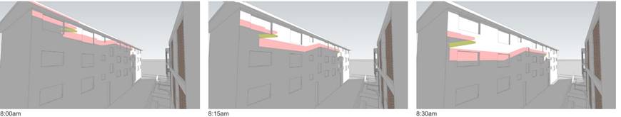
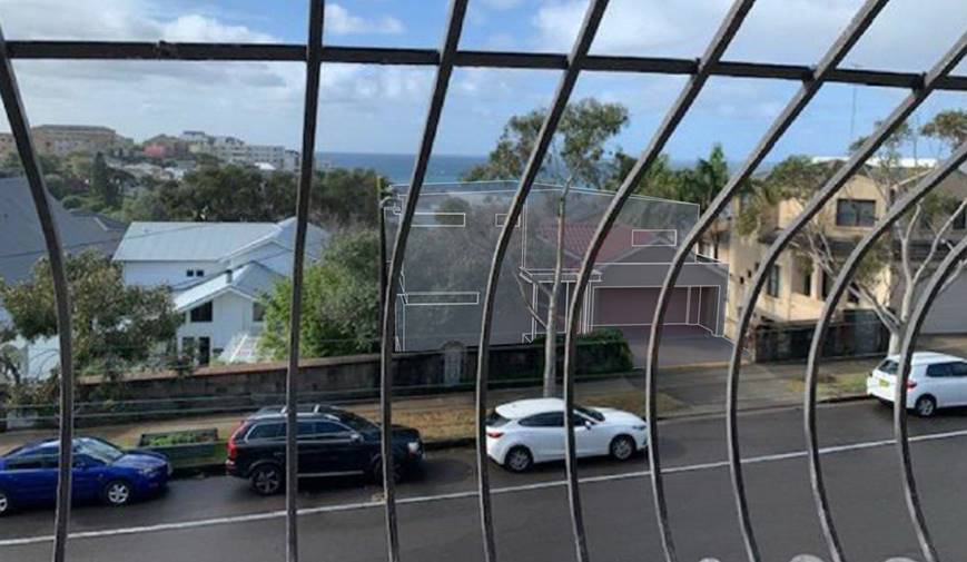
The RDCP also requires consideration of the planning principle set out in the matter of Tenacity Consulting v Warringah (2004) NSWLEC 140, the Land and Environment Court established a to assess whether the extent of view loss, which would result from the proposal is reasonable or whether a more skilful design would provide the same or reasonable levels of amenity for the develpoment whilst also providing a fair sharing of views. The planning principle provides a four stage method of assessing view loss. The properties in which views are taken from are identified in the photo and aerial image below.
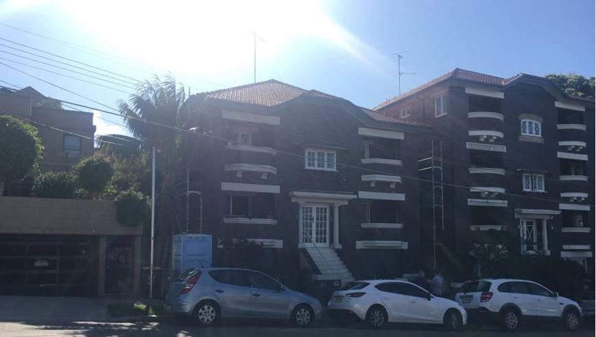
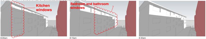
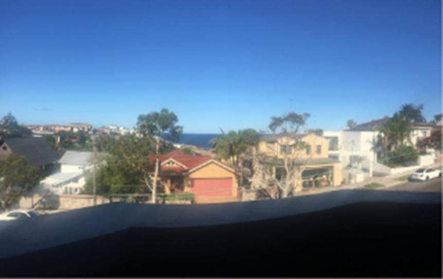
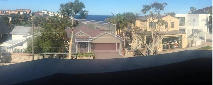
Photo: street view of apartment buildings at units 1-4/56 Beach Street at left and units 1-7/54 Beach Street at right. The apartments afected by views most include are at 1st floor level of each building –units 4 and 5 of 54 Beach Street and unit 4 of 56 Beach Street which is most severaly impacted. The lower level units don’t have any appreaibly valuable view and the otp level untis will not be appreciably impacted by the proposal - especially the 2nd amended scheme.
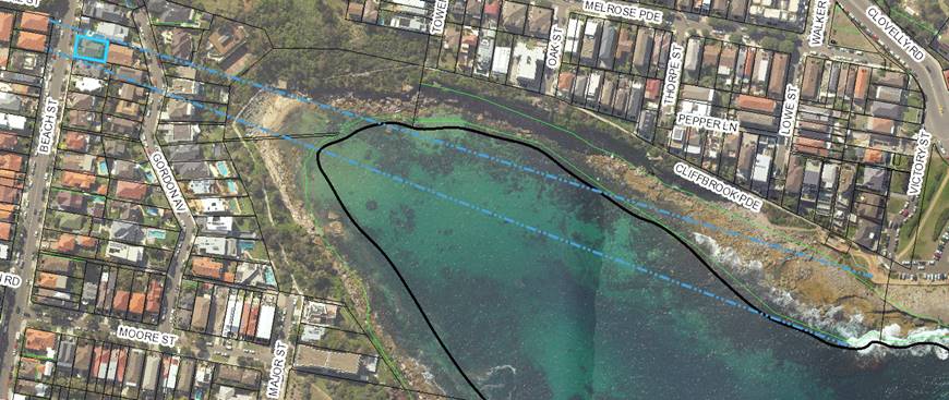
Figure 1: Diretion of views from middle level apartments.
1. Quality of Views:
The first step is the assessment of views to be affected. Water views are valued more highly than land views. Iconic views (e.g. of the Opera House, the Harbour Bridge or North Head) are valued more highly than views without icons. Whole views are valued more highly than partial views, e.g. a water view in which the interface between land and water is visible is more valuable than one in which it is obscured.
Affected views:
· 4/56 Beach Street
· 3/54 Beach Street
· 4/54 Beach Street
· 5/54 beach Street
4/56 Beach Street: The quality of this view is moderate given that it contains a view of interfacing land and water views however it is very close to the exsiting dwellings roof and obstructed by trees.
3/54 Beach Street: The quality of this view is along the northern side boundary and above the existing dwelling takes in parts of the interfacing headland and wash view interspersed with trees obstructing this veiw. This view is rated as moderate due to the obstructions.
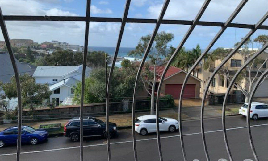
4/54 Beach Street: The quality of this view is moderate given that it contains a view of interfacing land and water views.
5/54 beach Street: The quality of this view is high as it takes in a broad expansive view of the ocean and interfacing land and water views.
2. From what part of the property the views are obtained?
The second step is to consider from what part of the property the views are obtained. For example the protection of views across side boundaries is more difficult than the protection of views from front and rear boundaries. In addition, whether the view is enjoyed from a standing or sitting position may also be relevant. Sitting views are more difficult to protect than standing views. The expectation to retain side views and sitting views is often unrealistic.
All veiws can be obtained from the seated position on the front balconies.
3. An assessment of the extent of the impact.
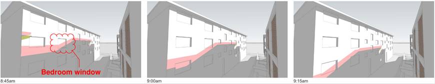
The third step is to assess the extent of the impact. This should be done for the whole of the property, not just for the view that is affected. The impact on views from living areas is more significant than from bedrooms or service areas (though views from kitchens are highly valued because people spend so much time in them). The impact may be assessed quantitatively, but in many cases this can be meaningless. For example, it is unhelpful to say that the view loss is 20% if it includes one of the sails of the Opera House. It is usually more useful to assess the view loss qualitatively as negligible, minor, moderate, severe or devastating.Sitting and standing distant district and ocean views will be lost from the following apartments located at 54 and 56 Beach Street:
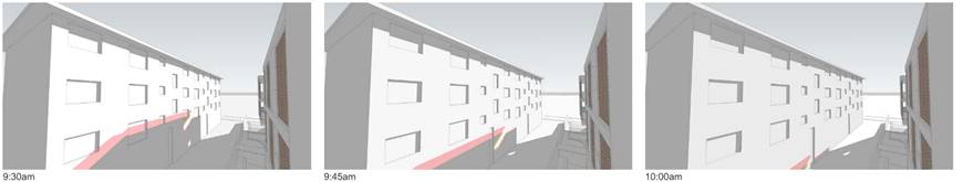
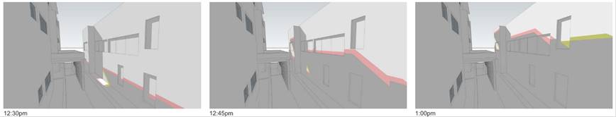
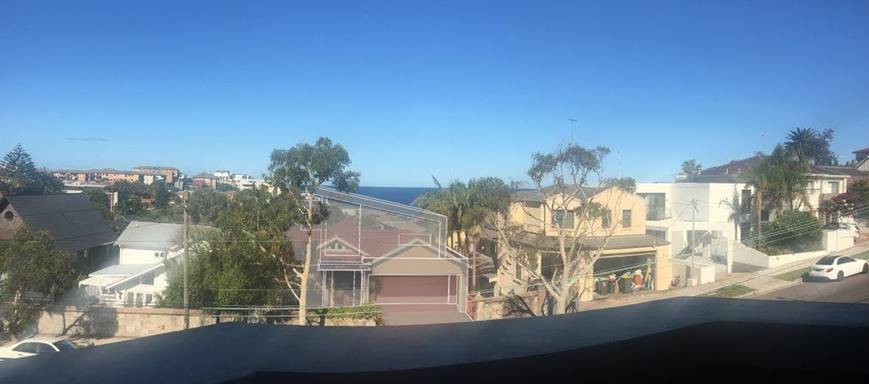
4/56 Beach Street: the extent of view loss from 1st set of amended plans is shown below. Furhter below is the extent of view loss from the 2nd set of amended plans. The views lost from the 1st set of amended plans is signficant given that moderate interfacing water and land views are lost. The retained view is of limited vaue given that it is obstructed by a tree located between the subject site and the development to the right at No. 61 Beach Street. It is at this point that the applicant was asked to explore a alternate designs to determine whether they would be more skilfull prusuant to step 4 of the plannign principle.
4/56 Beach Street: the extent of view loss from the 2nd set of amended plans deleting the skillion and reducing the height of the southern roof form is shown below. It shows that whilst views of the interfacing land and water views will be lost but a more expansive water veiw will be retained.
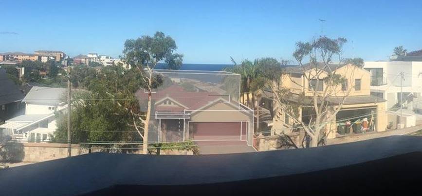
3/54 Beach Street: The proposal will result in the loss of the interfacing land and water veiw as ascertained from the wire cage image below. The ocean horizon views will be retained as a result of the deleted skillion roof which is similar to views rtained from unit 4/56 Beach Street - adjoining site to the south and also shown in the photomontage above.
4/54 Beach Street: the loss of views as a result of the 1st set of amendments is moderate as the expansiveness of the ocean view is shortened due to the lower skilliion roof. The deletion of the skillion roof form in the 2nd set of amended scheme– circled in the image below will retain more of these ocean views.
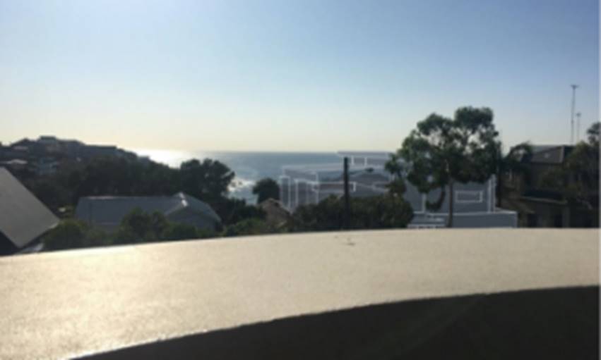
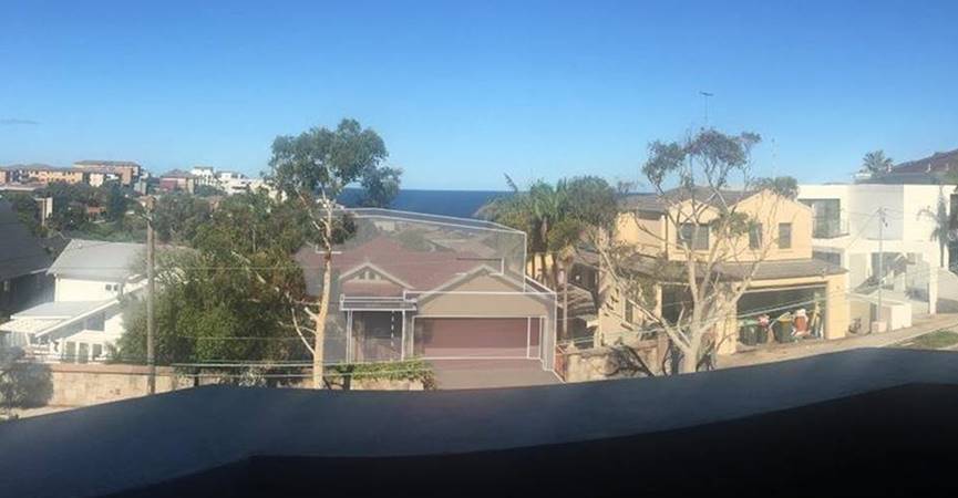
5/54 beach Street: The loss of views as a result of the 1st set of amended plans shows only a small portion of the interfacing land and water views in the foreground only will be lost which are considered minor. The 2nd set of amended plans that delete the skillion further improves views over the top of the development beind the street tree. The impact on views from No. 5/54 Beach Street is considered minor.
4. An assessment of the reasonableness of the proposal that is causing the impact.
The fourth step is to assess the reasonableness of the proposal that is causing the impact. A development that complies with all planning controls would be considered more reasonable than one that breaches them. Where an impact on views arises as a result of non-compliance with one or more planning controls, even a moderate impact may be considered unreasonable. With a complying proposal, the question should be asked whether a more skilful design could provide the applicant with the same development potential and amenity and reduce the impact on the views of neighbours. If the answer to that question is no, then the view impact of a complying development would probably be considered acceptable and the view sharing reasonable.
The 2nd amended scheme is generally considered reasonable having regard to the relevant objectives under the RLEP 2012 and RDCP 2013. In particular, the proposed development at the front has the appearance of a 2 storey built form which is consistent with the prevailing character along this side of Beach Street. The components that do not satisfy relevant numerical standards and controls such as overall heights and external wall heights are minor and it is not considered that that requiring compliance would retain high quality interfacing land and water views with particular regard to vies from Units 3 and 4 at No. 54 Beach Street.
Further, if the development as a whole were reduced in height particularly wall or overall building heights to meet the maximum it would in the opinion of the assesment officer result in an inordinately reduced scale within the streetscape that is well below that which exists within the street and the amenitiy of the upper level living areas anticpated by objectives of the RLEP standards an RDCP controls.
The proposed developmeent which seeks to take advantage of sites proxiity to the foreshore is considered to be a reasonable form of devleopment that is consistent with the built form of other develpoments in this area.
Overall, the level of view sharing is considered reasonable having regard to the principles defined in the Land and Environment Court by Senior Commissioner Roseth in Tenacity v Warringah Council (2004). These include the value of the view, the areas where the views are obtained from, the extent of impact on the views and the reasonableness of the development and it is considdered that whilst the porposed devleoment will have a significant impact on the interfacing land and water views from units 3 and 4 at No. 54 Beach Street it is considered that porposal has been designed as skilfully as possible without significantly detracting from the amenity for a site locaed in the foreshore area.
10. Conclusion
That the application to alterations and additions to existing dwelling at lower ground, ground and first floor levels (variation to height control) be approved (subject to conditions) for the following reasons:
· The proposal is consistent with the relevant objectives contained within the RLEP 2012 and the relevant requirements of the RDCP 2013
· The proposal is consistent with the specific objectives of the R2 zone.
· The scale and design of the proposal is considered to be suitable for the location and is compatible with the desired future character of the locality.
· The development enhances the visual quality of the public domain/streetscape
· The proposed development will make a positive contribution to the commercial centre
Appendix 1: Referrals
1. Internal referral comments:
1.1. Heritage planner
1.2. Development Engineer
An application has been received for alterations and additions at the above site.
This report is based on the following plans and documentation:
· Architectural Plans by Edifice Design and dated 25.11.19;
· Statement of Environmental Effects by Zane Solutions
Undergrounding of power lines to site
At the ordinary Council meeting on the 27th May 2014 it was resolved that;
Should a mains power distribution pole be located on the same side of the street and within 15m of the development site, the applicant must meet the full cost for Ausgrid to relocate the existing overhead power feed from the distribution pole in the street to the development site via an underground UGOH connection.
The subject is not located within 15m of a power pole on the same side of the street hence the above clause is not applicable.
Landscape Comments
There are no existing trees, covered by Part B5 (Preservation of Trees and Vegetation) in Council's DCP 2013, that will be affected by this proposal.
Appendix 2: Applicant’s written request seeking to justify the contravention of the development standard
Appendix 3: DCP Compliance Table
3.1 Section C1: Low Density Residential
|
DCP Clause |
Controls |
Proposal |
Compliance (Yes/No/NA/ Conditioned) |
|
|
Classification |
Zoning = R2 |
Permissible |
|
2 |
Site planning |
|
|
|
2.1 |
Minimum lot size and frontage |
||
|
|
|
15.24m frontage 352m2 |
|
|
2.3 |
Site coverage |
||
|
|
301 to 450 sqm 55% |
Reduced site coverage at lower ground level 36% to provide for rear yard area |
Yes |
|
2.4 |
Landscaping and permeable surfaces |
||
|
|
i) 301 to 450 sqm 25% ii) Deep soil minimum width 900mm. iii) Maximise permeable surfaces to front iv) Retain existing or replace mature native trees v) Minimum 1 canopy tree (8m mature). Smaller (4m mature) If site restrictions apply. vi) Locating paved areas, underground services away from root zones. |
Increased from 25% to 37% |
Yes |
|
2.5 |
Private open space (POS) |
||
|
|
Dwelling & Semi-Detached POS |
|
|
|
|
301 to 450 sqm 6m x 6m |
|
Yes |
|
3 |
Building envelope |
||
|
3.1 |
Floor space ratio LEP 2012 = 0.75:1 |
Proposed FSR = 0.55:1 |
Yes |
|
3.2 |
Building height |
|
|
|
|
Maximum overall height LEP 2012 = 9.5m |
Proposed = 9.68m amended.
Original = 11.52m |
No see Clause 4.6 assessment |
|
|
i) Maximum external wall height = 7m (Minimum floor to ceiling height = 2.7m) ii) Sloping sites = 8m iii) Merit assessment if exceeded |
Proposed =
Southern elevation = 8.055m at front and 8.825m at rear.
Northern elevation = 9.225m at front and 9.295m at rear |
No, see key issues section of this report
|
|
3.3 |
Setbacks |
||
|
3.3.1 |
Front setbacks i) Average setbacks of adjoining (if none then no less than 6m) Transition area then merit assessment.
ii) Corner allotments: Secondary street frontage: - 900mm for allotments with primary frontage width of less than 7m - 1500mm for all other sites iii) do not locate swimming pools, above-ground rainwater tanks and outbuildings in front |
Unchanged at ground and lower ground level. Upper level setback varies between 3.645m and 4.335m which is considered to be integrated with the existing dwelling.
|
Yes |
|
3.3.2 |
Side setbacks: Dwellings: · Frontage over 12m = 1200mm (Gnd & 1st floor), 1800mm above.
Refer to 6.3 and 7.4 for outbuildings |
Lower ground level – no change
Ground level extension associated with the western end of the garage is setback 630mm in line with the existing garage.
Upper level: · North: 1.99m north · South: 1.8m |
NA
No, however the addition is very small merely maintaining the existing building line which allows for appropriate depth for the garage and will not result in any appreciable difference in impacts from this level.
Yes Yes |
|
|
|||
|
3.3.3 |
Rear setbacks i) Minimum 25% (5.8375m) of allotment depth or 8m, whichever lesser. Note: control does not apply to corner allotments. ii) Provide greater than aforementioned or demonstrate not required, having regard to: - Existing predominant rear setback line - reasonable view sharing (public and private) - protect the privacy and solar access iii) Garages, carports, outbuildings, swimming or spa pools, above-ground water tanks, and unroofed decks and terraces attached to the dwelling may encroach upon the required rear setback, in so far as they comply with other relevant provisions of this DCP. |
Lower ground roof: 5.5m Ground level: 5.5m
Upper level: 7.56m |
No for LG and G levels however these setbacks have increased from existing.
Yes |
|
4 |
Building design |
||
|
4.1 |
General |
||
|
|
Respond specifically to the site characteristics and the surrounding natural and built context - · articulated to enhance streetscape · stepping building on sloping site, · no side elevation greater than 12m · encourage innovative design |
|
Yes. |
|
4.4 |
Roof Design and Features |
|
|
|
|
i) Suitable for existing · Celestial windows and skylights vii) Sympathetic to design of dwelling Mechanical equipment viii) Contained within roof form and not visible from street and surrounding properties. |
Skylights provided |
Yes |
|
4.5 |
Colours, Materials and Finishes |
||
|
|
i) Schedule of materials and finishes ii) Finishing is durable and non-reflective. iii) Minimise expanses of rendered masonry at street frontages (except due to heritage consideration) iv) Articulate and create visual interest by using combination of materials and finishes. v) Suitable for the local climatic to withstand natural weathering, ageing and deterioration. vi) recycled and re-use sandstone (See also section 8.3 foreshore area.) |
|
Yes |
|
4.6 |
Earthworks |
||
|
|
i) excavation and backfilling limited to 1m, unless gradient too steep ii) minimum 900mm side and rear setback iii) Step retaining walls iv) cut and fill for POS is terraced where site has significant slope: vii) adopt a split-level design viii) Minimise height and extent of any exposed under-croft areas. |
Proposed = >1m below existing stairs which are above adjoining land levels therefore no unreasonable impacts.
Generally consistent with existing in rear yard. |
No, see comment at left |
|
5 |
Amenity |
||
|
5.1 |
Solar access and overshadowing |
||
|
|
Solar access to proposed development: |
|
|
|
|
i) Portion of north-facing living room windows must receive a minimum of 3 hrs direct sunlight between 8am and 4pm on 21 June ii) POS (passive recreational activities) receive a minimum of 3 hrs of direct sunlight between 8am and 4pm on 21 June. |
|
Yes |
|
|
Solar access to neighbouring development: |
|
|
|
|
i) Portion of the north-facing living room windows must receive a minimum of 3 hours of direct sunlight between 8am and 4pm on 21 June. iv) POS (passive recreational activities) receive a minimum of 3 hrs of direct sunlight between 8am and 4pm on 21 June. v) solar panels on neighbouring dwellings, which are situated not less than 6m above ground level (existing), must retain a minimum of 3 hours of direct sunlight between 8am and 4pm on 21 June. If no panels, direct sunlight must be retained to the northern, eastern and/or western roof planes (not <6m above ground) of neighbouring dwellings. vi) Variations may acceptable be subject to: · Degree of meeting the FSR, height, setbacks and site coverage controls. · Orientation of the subject and adjoining allotments and subdivision pattern of the urban block. · Topography of the subject and adjoining allotments. · Location and level of the windows in question. · Shadows cast by existing buildings on the neighbouring allotments. |
The 1st amended scheme demonstrated that compliance is achieved. |
Yes |
|
5.2 |
Energy Efficiency and Natural Ventilation |
||
|
|
i) Provide day light to internalised areas within the dwelling (for example, hallway, stairwell, walk-in-wardrobe and the like) and any poorly lit habitable rooms via measures such as: · Skylights (ventilated) · Clerestory windows · Fanlights above doorways · Highlight windows in internal partition walls · living rooms contain windows and doors opening to outdoor areas Note: The sole reliance on skylight or clerestory window for natural lighting and ventilation is not acceptable |
|
Yes |
|
5.3 |
Visual Privacy |
||
|
|
Windows |
|
|
|
|
i) minimise any direct viewing habitable of proposed and neighbours habitable room windows by one or more of the following measures: - windows are offset or staggered - minimum 1600mm window sills - Install fixed and translucent glazing up 1600mm minimum effective sill. - Install fixed privacy screens to windows. - Creating a recessed courtyard (minimum 3m x 2m). ii) orientate living and dining windows away from similar opposite (that is front or rear or side courtyard |
Windows are generally appropriately located except for the following:
· Southern facing ground level retreat window (W22).
· North facing upper level living room windows (W26 & W27) |
Conditioned – 2b |
|
|
Balcony |
|
|
|
|
i) Upper floor balconies to street or rear yard of the site. (wrap around balcony to have a narrow width at side) ii) Privacy screens iii) minimise overlooking of POS via privacy screens (fixed, minimum of 1600mm high and achieve minimum of 70% opaqueness (glass, timber or metal slats and louvers) iv) Supplementary privacy devices: Screen planting and planter boxes Not sole privacy protection measure) v) vi) For sloping sites, step down and avoid large areas of ground floor decks or terraces. |
|
Conditioned – 2a
|
|
5.4 |
Acoustic Privacy |
||
|
|
i) noise sources not located adjacent to adjoining dwellings bedroom windows Attached dual occupancies ii) Reduce noise transmission between dwellings by: - Locate noise-generating areas and quiet areas adjacent to each other. - Locate less sensitive areas adjacent to the party wall to serve as noise buffer. |
|
Conditioned |
|
5.5 |
Safety and Security |
||
|
|
i) dwellings main entry on front elevation (unless narrow site) ii) Street numbering at front near entry. iii) 1 habitable room window (glazed area min 2 square metres) overlooking the street or a public place. iv) Front fences, parking facilities and landscaping does not to obstruct casual surveillance (maintain safe access) |
|
Yes |
|
5.6 |
View Sharing |
||
|
|
i) Reasonably maintain existing view corridors or vistas from the neighbouring dwellings, streets and public open space areas. ii) retaining existing views from the living areas are a priority over low use rooms iii) retaining views for the public domain takes priority over views for the private properties iv) fence design and plant selection must minimise obstruction of views v) Adopt a balanced approach to privacy protection and view sharing vi) Demonstrate any steps or measures adopted to mitigate potential view loss impacts in the DA. (certified height poles used) |
|
See key issues section above. |
|
6 |
Car Parking and Access |
||
|
6.1 |
Location of Parking Facilities: |
|
|
|
|
i) Maximum 1 vehicular access ii) Locate off rear lanes, or secondary street or iii) Locate behind front façade, within the dwelling or positioned to the side of the dwelling. Note: See 6.2 parking facilities forward of the front façade alignment may be considered. iv) Double width if: - Frontage >12m, - Consistent with pattern in the street; - Landscaping provided in the front yard. v) Minimise excavation for basement garages and scale of the front elevation vi) Avoid long driveways (impermeable surfaces) |
|
Yes
|
|
6.4 |
Driveway Configuration |
||
|
|
Maximum driveway width: - Double driveway – 5m Must taper driveway width at street boundary and at property boundary
|
|
No change |
|
6.5 |
Garage Configuration |
||
|
|
i) recessed behind front of dwelling ii) The maximum garage width (door and piers or columns): - Double garage – 6m iii) 5.4m minimum length of a garage iv) 2.6m max wall height of detached garages v) recess garage door 200mm to 300mm behind walls (articulation) vi) 600mm max. parapet wall or bulkhead vii) minimum clearance 2.2m AS2890.1 |
Bulk head reduced as part of amended plans
|
Yes
|
|
7 |
Fencing and Ancillary Development |
||
|
7.1 |
General - Fencing |
||
|
|
i) Use durable materials ii) sandstone not rendered or painted iii) don’t use steel post and chain wire, barbed wire or dangerous materials iv) Avoid expansive surfaces of blank rendered masonry to street |
|
Yes
|
|
7.2 |
Front Fencing |
||
|
|
i) 1200mm max. (Solid portion not exceeding 600mm), except for piers. - 1800mm max. provided upper two-thirds partially open (30% min), except for piers. ii) light weight materials used for open design and evenly distributed iii) 1800mm max solid front fence permitted in the following scenarios: - Site faces arterial road - Secondary street frontage (corner allotments) and fence is behind the alignment of the primary street façade (tapered down to fence height at front alignment). - avoid continuous blank walls (using a combination of materials, finishes and details, and/or incorporate landscaping (such as cascading plants)) iv) 150mm allowance (above 1800mm) for stepped sites v) Natural stone, face bricks and timber are preferred. Cast or wrought iron pickets may be used if compatible vi) Avoid roofed entry portal, unless complementary to established fencing pattern in heritage streetscapes. vii) Gates must not open over public land. viii) The fence must align with the front property boundary or the predominant fence setback line along the street. ix) Splay fence adjacent to the driveway to improve driver and pedestrian sightlines. |
Brick up existing entry with similar sandstone to existing front fence
|
Yes |
|
7.3 |
Side and rear fencing |
||
|
|
i) 1800mm maximum height (from existing ground level). Sloping sites step fence down (max. 2.2m). ii) Fence may exceed max. if level difference between sites iii) Tapper down to front fence height once past the front façade alignment. iv) Both sides treated and finished. |
|
NA |
|
7.6 |
Air conditioning equipment |
||
|
|
i) Minimise visibility from street. ii) Avoid locating on the street or laneway elevation of buildings. iii) Screen roof mounted A/C from view by parapet walls, or within the roof form. iv) Locate to minimise noise impacts on bedroom areas of adjoining dwellings. |
|
NA |
|
1.⇩ |
RLPP Dev Consent Conditions (dwellings dual occ) - DA/637/2019 - 59 Beach Street, COOGEE |
|
Responsible officer: Louis Coorey, Senior Environmental Planning Officer
File Reference: DA/637/2019
|
RLPP Dev Consent Conditions (dwellings dual occ) - DA/637/2019 - 59 Beach Street, COOGEE |
Attachment 1 |
|
Folder /DA No: |
DA/637/2019 |
|
Property: |
59 Beach Street, COOGEE NSW 2034 |
|
Proposal: |
Alterations and additions to existing dwelling at lower ground, ground and first floor levels |
|
Recommendation: |
Approval |
Development Consent Conditions
GENERAL CONDITIONS
The development must be carried out in accordance with the following conditions of consent.
These conditions have been applied to satisfy the relevant requirements of the Environmental Planning & Assessment Act 1979, Environmental Planning & Assessment Regulation 2000 and to provide reasonable levels of environmental amenity.
Approved Plans & Supporting Documentation
1. The development must be implemented substantially in accordance with the plans and supporting documentation listed below and endorsed with Council’s approved stamp, except where amended by Council in red and/or by other conditions of this consent:
|
Plan |
Drawn by |
Dated |
|
DA01 Rev C |
Edifice design architects |
27.10.20 |
|
DA02 Rev C |
27.10.20 |
|
|
DA04 Rev C |
27.10.20 |
|
|
DA05 Rev C |
27.10.20 |
|
|
DA06 Rev C |
27.10.20 |
|
|
DA07 Rev C |
27.10.20 |
|
|
DA08 Rev C |
27.10.20 |
|
|
DA09 Rev C |
27.10.20 |
|
|
DA10 Rev C |
27.10.20 |
|
|
DA11 Rev C |
27.10.20 |
|
|
DA16 Rev C |
27.10.20 |
|
BASIX Certificate No. |
Dated |
|
A364438 |
22 November 2019 |
Amendment of Plans & Documentation
2. The approved plans and documents must be amended in accordance with the following requirements:
a. A privacy screen having a height of 1.6m (measured above rear terrace of the following areas:
· Full length of the southern side of the lower ground level deck connected to the laundry.
· Full length of the northern side ground level balcony connected to the Master Bedroom.
· Full length of the southern and northern sides of the ground level rear balcony.
· Full length of the southern and northern sides of the upper level rear balcony.
All privacy screen/s must be constructed with either:
· Translucent or obscured glazing (The use of film applied to the clear glass pane is unacceptable);
· Fixed lattice/slats with individual openings not more than 30mm wide;
· Fixed vertical or horizontal louvres with the individual blades angled and spaced appropriately to prevent overlooking into the private open space or windows of the adjacent dwellings.
b. The following window/s must have a minimum sill height of 1.6m above floor level, or alternatively, the window/s are to be fixed and be provided with translucent, obscured, frosted or sandblasted glazing below this specified height:
· W26 & W27 northern facing windows at upper level floor
· W22 south facing retreat window at ground level
c. No consent is granted for the relocation of the rear boundary fence unless written consent is obtained from the owners of No. 8 Gordon Avenue.
REQUIREMENTS BEFORE A CONSTRUCTION CERTIFICATE CAN BE ISSUED
The following conditions of consent must be complied with before a ‘Construction Certificate’ is issued by either Randwick City Council or an Accredited Certifier. All necessary information to demonstrate compliance with the following conditions of consent must be included in the documentation for the construction certificate.
These conditions have been applied to satisfy the relevant requirements of the Environmental Planning & Assessment Act 1979, Environmental Planning & Assessment Regulation 2000, Council’s development consent conditions and to achieve reasonable levels of environmental amenity.
Consent Requirements
3. The requirements and amendments detailed in the ‘General Conditions’ must be complied with and be included in the construction certificate plans and associated documentation.
External Colours, Materials & Finishes
4. The colours, materials and surface finishes to the development must be consistent with the relevant plans, documentation and colour schedules provided with the development application.
5. The proposed ‘Brick infill’ to the existing pedestrian gate opening with matching sandstone should be carefully detailed to ensure the existing historic sandstone boundary wall and its capping stone are not removed or damaged. Removal of the later cement veneer on both sides of the opening should be considered, ensuring the capping stone above is supported in the process, and replaced with recycled stone blocks to fill the opening. Details of the proposed methodology, stone and drawing is to be submitted to and approved by Council’s Manager Development Assessment prior to a construction Certificate being issued for the development.
Section 7.12 Development Contributions
6. In accordance with Council’s Development Contributions Plan effective from 21 April 2015, based on the development cost of $1,002,011 the following applicable monetary levy must be paid to Council: $10,020.10.
The levy must be paid in cash, bank cheque or by credit card prior to a construction certificate being issued for the proposed development. The development is subject to an index to reflect quarterly variations in the Consumer Price Index (CPI) from the date of Council’s determination to the date of payment. Please contact Council on telephone 9093 6999 or 1300 722 542 for the indexed contribution amount prior to payment.
To calculate the indexed levy, the following formula must be used:
IDC = ODC x CP2/CP1
Where:
IDC = the indexed development cost
ODC = the original development cost determined by the Council
CP2 = the Consumer Price Index, All Groups, Sydney, as published by the ABS in respect of the quarter ending immediately prior to the date of payment
CP1 = the Consumer Price Index, All Groups, Sydney as published by the ABS in respect of the quarter ending immediately prior to the date of imposition of the condition requiring payment of the levy.
Council’s Development Contribution Plans may be inspected at the Customer Service Centre, Administrative Centre, 30 Frances Street, Randwick or at www.randwick.nsw.gov.au.
Compliance Fee
7. A development compliance and enforcement fee of $1,002.00 shall be paid to Council in accordance with Council’s adopted Fees & Charges Pricing Policy, prior to the issue of a Construction Certificate for development.
Long Service Levy Payments
8. The required Long Service Levy payment, under the Building and Construction Industry Long Service Payments Act 1986, must be forwarded to the Long Service Levy Corporation or the Council, in accordance with Section 6.8 of the Environmental Planning & Assessment Act 1979.
At the time of this development consent, Long Service Levy payment is applicable on building work having a value of $25,000 or more, at the rate of 0.35% of the cost of the works.
Sydney Water Requirements
9. All building, plumbing and drainage work must be carried out in accordance with the requirements of the Sydney Water Corporation.
The approved plans must be submitted to the Sydney Water Tap in™ online service, to determine whether the development will affect Sydney Water’s waste water and water mains, stormwater drains and/or easements, and if any further requirements need to be met.
The Sydney Water Tap in™ online service replaces the Quick Check Agents as of 30 November 2015
The Tap in™ service provides 24/7 access to a range of services, including:
· Building plan approvals
· Connection and disconnection approvals
· Diagrams
· Trade waste approvals
· Pressure information
· Water meter installations
· Pressure boosting and pump approvals
· Change to an existing service or asset, e.g. relocating or moving an asset.
Sydney Water’s Tap in™ in online service is available at:
The Certifier must ensure that the developer/owner has submitted the approved plans to Sydney Water Tap in online service.
REQUIREMENTS TO BE INCLUDED IN THE CONSTRUCTION CERTIFICATE
The requirements contained in the following conditions of consent must be complied with and details of compliance must be included in the construction certificate for the development.
These conditions have been applied to satisfy the relevant requirements of the Environmental Planning & Assessment Act 1979, Environmental Planning & Assessment Regulation 2000, Councils development consent conditions and to achieve reasonable levels of environmental amenity.
Compliance with the Building Code of Australia & Relevant Standards
10. In accordance with section 4.17 (11) of the Environmental Planning & Assessment Act 1979 and clause 98 of the Environmental Planning & Assessment Regulation 2000, it is a prescribed condition that all building work must be carried out in accordance with the provisions of the Building Code of Australia (BCA).
BASIX Requirements
11. In accordance with section 4.17 (11) of the Environmental Planning & Assessment Act 1979 and clause 97A of the Environmental Planning & Assessment Regulation 2000, the requirements and commitments contained in the relevant BASIX Certificate must be complied with.
The required commitments listed and identified in the BASIX Certificate must be included on the construction certificate plans, specifications and associated documentation, to the satisfaction of the Certifying Authority.
The design of the building must not be inconsistent with the development consent and any proposed variations to the building to achieve the BASIX commitments may necessitate a new development consent or amendment to the existing consent to be obtained, prior to a construction certificate being issued.
REQUIREMENTS PRIOR TO THE COMMENCEMENT OF ANY WORKS
The following conditions of consent must be complied with prior to the commencement of any works on the site. The necessary documentation and information must be provided to the Council or the ‘Certifier’, as applicable.
These conditions have been applied to satisfy the relevant requirements of the Environmental Planning & Assessment Act 1979, Environmental Planning & Assessment Regulation 2000 and to provide reasonable levels of public health, safety and environmental amenity.
Certification and Building Inspection Requirements
12. Prior to the commencement of any building works, the following requirements must be complied with:
a) a Construction Certificate must be obtained from the Council or an accredited certifier, in accordance with the provisions of the Environmental Planning & Assessment Act 1979.
A copy of the construction certificate, the approved development consent plans and consent conditions must be kept on the site at all times and be made available to the Council officers and all building contractors for assessment.
b) a Certifier must be appointed to carry out the necessary building inspections and to issue an occupation certificate; and
c) a principal contractor must be appointed for the building work, or in relation to residential building work, an owner-builder permit may be obtained in accordance with the requirements of the Home Building Act 1989, and the Certifier and Council are to be notified accordingly; and
d) the principal contractor must be advised of the required critical stage inspections and other inspections to be carried out, as specified by the Certifier; and
e) at least two days notice must be given to the Council, in writing, prior to commencing any works.
Home Building Act 1989
13. In accordance with section 4.17 (11) of the Environmental Planning & Assessment Act 1979 and clause 98 of the Environmental Planning & Assessment Regulation 2000, the relevant requirements of the Home Building Act 1989 must be complied with.
Details of the Licensed Building Contractor and a copy of the relevant Certificate of Home Warranty Insurance or a copy of the Owner-Builder Permit (as applicable) must be provided to the Certifier and Council.
Dilapidation Reports
14. A dilapidation report must be obtained from a Professional Engineer, Building Surveyor or other suitably qualified independent person, in the following cases:
· excavations for new dwellings, additions to dwellings, swimming pools or other substantial structures which are proposed to be located within the zone of influence of the footings of any dwelling, associated garage or other substantial structure located upon an adjoining premises;
· new dwellings or additions to dwellings sited up to shared property boundaries (e.g. additions to a semi-detached dwelling or terraced dwellings);
· excavations for new dwellings, additions to dwellings, swimming pools or other substantial structures which are within rock and may result in vibration and or potential damage to any dwelling, associated garage or other substantial structure located upon an adjoining premises;
· as otherwise may be required by the Certifier.
The dilapidation report shall include details of the current condition and status of any dwelling, associated garage or other substantial structure located upon the adjoining premises and shall include relevant photographs of the structures, to the satisfaction of the Certifier.
The dilapidation report must be submitted to the Council, the Certifier and the owners of the adjoining/nearby premises encompassed in the report, prior to commencing any site works (including any demolition work, excavation work or building work).
Construction Noise & Vibration Management
15. Noise and vibration emissions during the construction of the building and associated site works must not result in damage to nearby premises or result in an unreasonable loss of amenity to nearby residents and the relevant requirements of the Protection of the Environment Operations Act 1997 and NSW EPA Guidelines must be satisfied at all times.
Noise and vibration from any rock excavation machinery, pile drivers and all plant and equipment must be minimised, by using appropriate plant and equipment, silencers and the implementation of noise management strategies.
Construction Site Management Plan
16. A Construction Site Management Plan must be developed and implemented prior to the commencement of any works. The construction site management plan must include the following measures, as applicable to the type of development:
· location and construction of protective site fencing / hoardings;
· location of site storage areas/sheds/equipment;
· location of building materials for construction;
· provisions for public safety;
· dust control measures;
· details of proposed sediment and erosion control measures;
· site access location and construction
· details of methods of disposal of demolition materials;
· protective measures for tree preservation;
· location and size of waste containers/bulk bins;
· provisions for temporary stormwater drainage;
· construction noise and vibration management;
· construction traffic management details;
· provisions for temporary sanitary facilities.
The site management measures must be implemented prior to the commencement of any site works and be maintained throughout the works, to the satisfaction of Council.
A copy of the Construction Site Management Plan must be provided to the Certifier and Council prior to commencing site works. A copy must also be maintained on site and be made available to Council officers upon request.
Demolition Work
17. Demolition Work must be carried out in accordance with Australian Standard AS2601-2001, Demolition of Structures and relevant work health and safety requirements.
A Demolition Work Plan must be prepared for the demolition works which should be submitted to the Certifier, not less than two (2) working days before commencing any demolition work. A copy of the Demolition Work Plan must be maintained on site and be made available to Council officers upon request.
If the work involves asbestos products or materials, a copy of the Demolition Work Plan must also be provided to Council not less than 2 days before commencing those works.
Demolition & Construction Waste Plan
18. A Demolition and Construction Waste Management Plan (WMP) must be development and implemented for the development.
The Waste Management Plan must provide details of the type and quantities of demolition and construction waste materials, proposed re-use and recycling of materials, methods of disposal and details of recycling outlets and land fill sites.
Where practicable waste materials must be re-used or recycled, rather than disposed and further details of Council's requirements including relevant guidelines and pro-forma WMP forms can be obtained from Council's Customer Service Centre or by telephoning Council on 1300 722 542.
Details and receipts verifying the recycling and disposal of materials must be kept on site at all times and presented to Council officers upon request.
Public Utilities
19. A Public Utility Impact Assessment must be carried out on all public utility services on the site, roadway, nature strip, footpath, public reserve or any public areas associated with and/or adjacent to the development/building works and include relevant information from public utility authorities and exploratory trenching or pot-holing, if necessary, to determine the position and level of service.
20. The applicant must meet the full cost for telecommunication companies, gas providers, Ausgrid, and Sydney Water to adjust/repair/relocate their services as required. The applicant must make the necessary arrangements with the service authority.
REQUIREMENTS DURING CONSTRUCTION & SITE WORK
The following conditions of consent must be complied with during the demolition, excavation and construction of the development.
These conditions have been applied to satisfy the relevant requirements of the Environmental Planning & Assessment Act 1979, Environmental Planning & Assessment Regulation 2000 and to provide reasonable levels of public health, safety and environmental amenity during construction.
Inspections during Construction
21. Building works are required to be inspected by the Certifier, in accordance with section 6.5 of the Environmental Planning & Assessment Act 1979 and clause 162A of the Environmental Planning & Assessment Regulation 2000, to monitor compliance with the relevant standards of construction, Council’s development consent and the construction certificate.
Site Signage
22. A sign must be erected and maintained in a prominent position on the site for the duration of the works, which contains the following details:
· name, address, contractor licence number and telephone number of the principal contractor, including a telephone number at which the person may be contacted outside working hours, or owner-builder permit details (as applicable)
· name, address and telephone number of the Certifier,
· a statement stating that “unauthorised entry to the work site is prohibited”.
Restriction on Working Hours
23. Building, demolition and associated site works must be carried out in accordance with the following requirements:
|
Activity |
Permitted working hours |
|
All building, demolition and site work, including site deliveries (except as detailed below) |
· Monday to Friday - 7.00am to 5.00pm · Saturday - 8.00am to 5.00pm · Sunday & public holidays - No work permitted |
|
Excavating or sawing of rock, use of jack-hammers, pile-drivers, vibratory rollers/compactors or the like
|
· Monday to Friday - 8.00am to 5.00pm · Saturday - No work permitted · Sunday & public holidays - No work permitted |
An application to vary the abovementioned hours may be submitted to Council’s Manager Health, Building & Regulatory Services for consideration and approval to vary the specified hours may be granted in exceptional circumstances and for limited occasions (e.g. for public safety, traffic management or road safety reasons). Any applications are to be made on the standard application form and include payment of the relevant fees and supporting information. Applications must be made at least 10 days prior to the date of the proposed work and the prior written approval of Council must be obtained to vary the standard permitted working hours.
Removal of Asbestos Materials
24. Any work involving the demolition, storage or disposal of asbestos products and materials must be carried out in accordance with the following requirements:
· Occupational Health & Safety legislation and WorkCover NSW requirements
· Randwick City Council’s Asbestos Policy
· A WorkCover licensed demolition or asbestos removal contractor must undertake removal of more than 10m2 of bonded asbestos (or as otherwise specified by WorkCover or relevant legislation). Removal of friable asbestos material must only be undertaken by contractor that holds a current friable asbestos removal licence. A copy of the relevant licence must be provided to the Certifier.
· On sites involving the removal of asbestos, a sign must be clearly displayed in a prominent visible position at the front of the site, containing the words ‘DANGER ASBESTOS REMOVAL IN PROGRESS’ and include details of the licensed contractor.
· Asbestos waste must be stored, transported and disposed of in compliance with the Protection of the Environment Operations Act 1997 and the Protection of the Environment Operations (Waste) Regulation 2005. Details of the landfill site (which must be lawfully able to receive asbestos materials) must be provided to the Certifier.
· A Clearance Certificate or Statement, prepared by a suitably qualified person (i.e. an occupational hygienist, licensed asbestos assessor or other competent person), must be provided to Council and the Certifier upon completion of the asbestos related works which confirms that the asbestos material have been removed appropriately and the relevant conditions of consent have been satisfied.
A copy of Council’s Asbestos Policy is available on Council’s web site at www.randwick.nsw.gov.au in the Building & Development Section or a copy can be obtained from Council’s Customer Service Centre.
Excavations, Back-filling & Retaining Walls
25. All excavations and backfilling associated with the erection or demolition of a building must be executed safely in accordance with appropriate professional standards and excavations must be properly guarded and supported to prevent them from being dangerous to life, property or buildings.
Retaining walls, shoring or piling must be provided to support land which is excavated in association with the erection or demolition of a building, to prevent the movement of soil and to support the adjacent land and buildings, if the soil conditions require it. Adequate provisions are also to be made for drainage.
Details of proposed retaining walls, shoring, piling or other measures are to be submitted to and approved by the Certifier.
Support of Adjoining Land
26. In accordance with section 4.17 (11) of the Environmental Planning & Assessment Act 1979 and clause 98 E of the Environmental Planning & Assessment Regulation 2000, it is a prescribed condition that the adjoining land and buildings located upon the adjoining land must be adequately supported at all times.
27. Prior to undertaking any demolition, excavation or building work in the following circumstances, a report must be obtained from a professional engineer which details the methods of support for the dwelling or associated structure on the adjoining land, to the satisfaction of the Certifier:
· when undertaking excavation or building work within the zone of influence of the footings of a dwelling or associated structure that is located on the adjoining land;
· when undertaking demolition work to a wall of a dwelling that is built to a common or shared boundary (e.g. semi-detached or terrace dwelling);
· when constructing a wall to a dwelling or associated structure that is located within 900mm of a dwelling located on the adjoining land;
· as may be required by the Certifier.
The demolition, excavation and building work and the provision of support to the dwelling or associated structure on the adjoining land, must also be carried out in accordance with the abovementioned report, to the satisfaction of the Certifier.
Sediment & Erosion Control
28. Sediment and erosion control measures, must be implemented throughout the site works in accordance with the manual for Managing Urban Stormwater – Soils and Construction, published by Landcom.
Details of the sediment and erosion control measures to be implemented on the site must be included in with the Construction Management Plan and be provided to the Certifier and Council. A copy must also be maintained on site and be made available to Council officers upon request.
Public Safety & Site Management
29. Public safety and convenience must be maintained at all times during demolition, excavation and construction works and the following requirements must be complied with:
a) Public access to the building site and materials must be restricted by existing boundary fencing or temporary site fencing having a minimum height of 1.5m, to Council’s satisfaction.
Temporary site fences are required to be constructed of cyclone wire fencing material and be structurally adequate, safe and constructed in a professional manner. The use of poor quality materials or steel reinforcement mesh as fencing is not permissible.
b) Building materials, sand, soil, waste materials, construction equipment or other articles must not be placed upon the footpath, roadway or nature strip at any time.
c) The road, footpath, vehicular crossing and nature strip must be maintained in a good, safe, clean condition and free from any excavations, obstructions, trip hazards, goods, materials, soils or debris at all times. Any damage caused to the road, footway, vehicular crossing, nature strip or any public place must be repaired immediately, to the satisfaction of Council.
d) All building and site activities (including storage or placement of materials or waste and concrete mixing/pouring/pumping activities) must not cause or be likely to cause ‘pollution’ of any waters, including any stormwater drainage systems, street gutters or roadways.
Note: It is an offence under the Protection of the Environment Operations Act 1997 to cause or be likely to cause ‘pollution of waters’, which may result in significant penalties and fines.
e) Access gates and doorways within site fencing, hoardings and temporary site buildings or amenities must not open out into the road or footway.
f) Site fencing, building materials, bulk bins/waste containers and other articles must not be located upon the footpath, roadway or nature strip at any time without the prior written approval of the Council. Applications to place a waste container in a public place can be made to Council’s Health, Building and Regulatory Services department.
g) Adequate provisions must be made to ensure pedestrian safety and traffic flow during the site works and traffic control measures are to be implemented in accordance with the relevant provisions of the Roads and Traffic Manual “Traffic Control at Work Sites” (Version 4), to the satisfaction of Council.
h) A Road / Asset Opening Permit must be obtained from Council prior to carrying out any works within or upon a road, footpath, nature strip or in any public place, in accordance with section 138 of the Roads Act 1993 and all of the conditions and requirements contained in the Road / Asset Opening Permit must be complied with. Please contact Council’s Road/Asset Openings officer on 9093 6691 for further details.
i) Temporary toilet facilities are to be provided, at or in the vicinity of the work site throughout the course of demolition and construction, to the satisfaction of WorkCover NSW and the toilet facilities must be connected to a public sewer or other sewage management facility approved by Council.
Site Signage
30. A sign must be erected and maintained in a prominent position on the site for the duration of the works, which contains the following details:
· name, address, contractor licence number and telephone number of the principal contractor, including a telephone number at which the person may be contacted outside working hours, or owner-builder permit details (as applicable)
· name, address and telephone number of the Certifier,
· a statement stating that “unauthorised entry to the work site is prohibited”.
Survey Requirements
31. A Registered Surveyor’s check survey certificate or other suitable documentation must be obtained at the following stage/s of construction to demonstrate compliance with the approved setbacks, levels, layout and height of the building to the satisfaction of the Certifier:
· prior to construction (pouring of concrete) of the footings or first completed floor slab,
· upon completion of the building, prior to issuing an occupation certificate,
· as otherwise may be required by the Certifier.
The survey documentation must be forwarded to the Certifier and a copy is to be forwarded to the Council, if the Council is not the Certifier for the development.
Building Encroachments
32. There must be no encroachment of any structures or building work onto Council’s road reserve, footway, nature strip or public place.
REQUIREMENTS PRIOR TO THE ISSUE OF AN OCCUPATION CERTIFICATE
The following conditions of consent must be complied with prior to the ‘Certifier’ issuing an ‘Occupation Certificate’.
These conditions have been applied to satisfy the relevant requirements of the Environmental Planning & Assessment Act 1979, Environmental Planning & Assessment Regulation 2000, Council’s development consent and to maintain reasonable levels of public health, safety and amenity.
Occupation Certificate Requirements
33. An Occupation Certificate must be obtained from the Certifier prior to any occupation of the building work encompassed in this development consent (including alterations and additions to existing buildings), in accordance with the relevant provisions of the Environmental Planning & Assessment Act 1979.
Council’s Infrastructure, Vehicular Crossings, street verge
34. The applicant must meet the full cost for Council or a Council approved contractor to repair/replace any damaged sections of Council's footpath, kerb & gutter, nature strip etc which are due to building works being carried out at the above site. This includes the removal of cement slurry from Council's footpath and roadway.
35. All external civil work to be carried out on Council property (including the installation and repair of roads, footpaths, vehicular crossings, kerb and guttering and drainage works), must be carried out in accordance with Council's "Crossings and Entrances – Contributions Policy” and “Residents’ Requests for Special Verge Crossings Policy” and the following requirements:
a) Details of the proposed civil works to be carried out on Council land must be submitted to Council in a Civil Works Application Form. Council will respond, typically within 4 weeks, with a letter of approval outlining conditions for working on Council land, associated fees and workmanship bonds. Council will also provide details of the approved works including specifications and construction details.
b) Works on Council land, must not commence until the written letter of approval has been obtained from Council and heavy construction works within the property are complete. The work must be carried out in accordance with the conditions of development consent, Council’s conditions for working on Council land, design details and payment of the fees and bonds outlined in the letter of approval.
c) The civil works must be completed in accordance with the above, prior to the issuing of an occupation certificate for the development, or as otherwise approved by Council in writing.
36. That part of the naturestrip upon Council's footway which is damaged during the construction of the proposed works shall be excavated to a depth of 150mm, backfilled with topsoil equivalent with 'Organic Garden Mix' as supplied by Australian Native Landscapes, and re-turfed with Kikuyu turf or similar. Such works shall be completed at the applicant’s expense.
BASIX Requirements & Certification
37. In accordance with Clause 154B of the Environmental Planning & Assessment Regulation 2000, a Certifier must not issue an Occupation Certificate for this development, unless it is satisfied that any relevant BASIX commitments and requirements have been satisfied.
Relevant documentary evidence of compliance with the BASIX commitments is to be forwarded to the Certifier and Council upon issuing an Occupation Certificate.
Council’s Infrastructure & Vehicular Crossings
38. All external civil work to be carried out on Council property (including the installation and repair of roads, footpaths, vehicular crossings, kerb and guttering and drainage works), must be carried out in accordance with Council's Policy for "Vehicular Access and Road and Drainage Works" and the following requirements:
a) All work on Council land must be carried out by Council, unless specific written approval has been obtained from Council to use non-Council contractors.
b) Details of the proposed civil works to be carried out on Council land must be submitted to Council in a Pre-paid Works Application Form, prior to issuing an occupation certificate, together with payment of the relevant fees.
c) If it is proposed to use non-Council contractors to carry out the civil works on Council land, the work must not commence until the written approval has been obtained from Council and the work must be carried out in accordance with the conditions of consent, Council’s design details and payment of a Council design and supervision fee.
d) The civil works must be completed in accordance with Council’s conditions of consent and approved design and construction documentation, prior to occupation of the development, or as otherwise approved by Council in writing.
OPERATIONAL CONDITIONS
The following operational conditions must be complied with at all times, throughout the use and operation of the development.
These conditions have been applied to satisfy the relevant requirements of the Environmental Planning & Assessment Act 1979, Environmental Planning & Assessment Regulation 2000, Council’s development consent and to maintain reasonable levels of public health and environmental amenity.
External Lighting
39. External lighting to the premises must be designed and located so as to minimise light-spill beyond the property boundary or cause a public nuisance.
Waste Management
40. Adequate provisions are to be made within the premises for the storage and removal of waste and recyclable materials, to the satisfaction of Council.
Plant & Equipment – Noise Levels
41. The operation of all plant and equipment on the premises shall not give rise to an ‘offensive noise’ as defined in the Protection of the Environment Operations Act 1997 and Regulations.
In this regard, the operation of the plant and equipment shall not give rise to an LAeq, 15 min sound pressure level at any affected premises that exceeds the background LA90, 15 min noise level, measured in the absence of the noise source/s under consideration by more than 5dB(A) in accordance with relevant NSW Environment Protection Authority (EPA) Noise Control Guidelines.
GENERAL ADVISORY NOTES
The following information is provided for your assistance to ensure compliance with the Environmental Planning & Assessment Act 1979, Environmental Planning & Assessment Regulation 2000, or other relevant legislation and requirements. This information does not form part of the conditions of development consent pursuant to Section 4.17 of the Act.
A1 The requirements and provisions of the Environmental Planning & Assessment Act 1979 and Environmental Planning & Assessment Regulation 2000, must be fully complied with at all times.
Failure to comply with these requirements is an offence, which renders the responsible person liable to a maximum penalty of $1.1 million. Alternatively, Council may issue a penalty infringement notice (for up to $3,000) for each offence. Council may also issue notices and orders to demolish unauthorised or non-complying building work, or to comply with the requirements of Council’s development consent.
A2 Underground assets (e.g. pipes, cables etc.) may exist in the area that is subject to your application. In the interests of health and safety and in order to protect damage to third party assets please contact Dial before you dig at www.1100.com.au or telephone on 1100 before excavating or erecting structures (This is the law in NSW). If alterations are required to the configuration, size, form or design of the development upon contacting the Dial before You Dig service, an amendment to the development consent (or a new development application) may be necessary. Individuals owe asset owners a duty of care that must be observed when working in the vicinity of plant or assets. It is the individual’s responsibility to anticipate and request the nominal location of plant or assets on the relevant property via contacting the Dial before you dig service in advance of any construction or planning activities.
A3 The applicant is to advise Council in writing and/or photographs of any signs of existing damage to the Council roadway, footway, or verge prior to the commencement of any building/demolition works.
A4 Further information and details on Council's requirements for trees on development sites can be obtained from the recently adopted Tree Technical Manual, which can be downloaded from Council’s website at the following link, http://www.randwick.nsw.gov.au - Looking after our environment – Trees – Tree Management Technical Manual; which aims to achieve consistency of approach and compliance with appropriate standards and best practice guidelines.
A5 In accordance with the requirements of the Environmental Planning & Assessment Act 1979, building works, including associated demolition and excavation works (as applicable) must not be commenced until:
§ A Construction Certificate has been obtained from an Accredited Certifier or Council,
§ An Accredited Certifier or Council has been appointed as the Certifier for the development,
§ Council and the Certifier have been given at least 2 days notice (in writing) prior to commencing any works.
A6 Council can issue your Construction Certificate and be your Certifier for the development, to undertake inspections and ensure compliance with the development consent and relevant building regulations. For further details contact Council on 9093 6944.
A7 This determination does not include an assessment of the proposed works under the Building Code of Australia (BCA) and other relevant Standards. All new building work (including alterations and additions) must comply with the BCA and relevant Standards and you are advised to liaise with your architect, engineer and building consultant prior to lodgement of your construction certificate.
A8 Any proposed amendments to the design and construction of the building may require a new development application or a section 4.55 amendment to the existing consent to be obtained from Council, before carrying out such works
A9 A Local Approval application must be submitted to and be approved by Council prior to commencing any of the following activities on a footpath, road, nature strip or in any public place:-
§ Install or erect any site fencing, hoardings or site structures
§ Operate a crane or hoist goods or materials over a footpath or road
§ Placement of a waste skip or any other container or article.
For further information please contact Council on 9093 6971.
A10 Specific details of the location of the building/s should be provided in the Construction Certificate to demonstrate that the proposed building work will not encroach onto the adjoining properties, Council’s road reserve or any public place.
A11 This consent does not authorise any trespass or encroachment upon any adjoining or supported land or building whether private or public. Where any underpinning, shoring, soil anchoring (temporary or permanent) or the like is proposed to be carried out upon any adjoining or supported land, the land owner or principal contractor must obtain:
§ the consent of the owners of such adjoining or supported land to trespass or encroach, or
§ an access order under the Access to Neighbouring Land Act 2000, or
§ an easement under section 88K of the Conveyancing Act 1919, or
§ an easement under section 40 of the Land & Environment Court Act 1979, as appropriate.
Section 177 of the Conveyancing Act 1919 creates a statutory duty of care in relation to support of land. Accordingly, a person has a duty of care not to do anything on or in relation to land being developed (the supporting land) that removes the support provided by the supporting land to any other adjoining land (the supported land).
A12 The finished ground levels external to the building must be consistent with the development consent and are not to be raised, other than for the provision of approved paving or the like on the ground
A13 Prior to commencing any works, the owner/builder should contact Dial Before You Dig on 1100 or www.dialbeforeyoudig.com.au and relevant Service Authorities, for information on potential underground pipes and cables within the vicinity of the development site.
A14 An application must be submitted to an approved by Council prior to the installation and operation of any proposed greywater or wastewater treatment systems, in accordance with the Local Government Act 1993.
Greywater/Wastewater treatment systems must comply with the relevant requirements and guidelines produced by NSW Health, NSW Office of Environment and Heritage and other relevant regulatory requirements.
|
Development Application Report No. D72/20
|
|
Subject: 9 Carlton Street, Kensington (DA/92/2018/B) |
Proposal: Modification to approved development for proposed amendments to internal layout, external windows of the top level and increased height of the building
Ward: West Ward
Applicant: DEM Australia P/L
Owner: Ideal Kensington Pty Ltd
Cost of works: N/A
Reason for referral: More than 10 submissions received by way of objection
That the RLPP, as the consent authority, approve the application made under Section 4.55 of the Environmental Planning and Assessment Act 1979, as amended, to modify Development Application No. DA/92/2018 for modification to approved development for proposed amendments to internal layout, external windows of the top level and increased height of the building at No. 9 Carlton Street, in the following manner:
· Amend Condition 1 to read:
1. The development must be implemented substantially in accordance with the plans and supporting documentation listed below and endorsed with Council’s approved stamp:
|
Drawn by |
Dated |
|
|
A-1.01 Revision DA-A |
MKD Architects |
February 2018 |
|
A-2.05 Revision DA-A |
MKD Architects |
February 2018 |
|
A-2.06 Revision DA-A |
MKD Architects |
February 2018 |
|
A-3.02 Revision DA-A |
MKD Architects |
February 2018 |
|
A-3.04 Revision DA-A |
MKD Architects |
February 2018 |
|
A-4.01 Revision DA-A |
MKD Architects |
February 2018 |
|
A-4.02 Revision DA-A |
MKD Architects |
February 2018 |
|
A-4.03 Revision DA-A |
MKD Architects |
February 2018 |
|
A-4.04 Revision DA-A |
MKD Architects |
February 2018 |
|
BASIX Certificate No. |
Dated |
|
820143M_03 |
5 February 2018 |
EXCEPT where amended by:
· Council in red on the approved plans; and/or
· Other conditions of this consent; and/or
· the following Section 4.55 “B” plans and supporting documents only in so far as they relate to the modifications highlighted on the Section 4.55 plans and detailed in the Section 4.55 “B” application:
|
Plan |
Drawn by |
Dated |
|
arsk1204 Rev No. a01 |
dem |
25/03/20 |
|
arsk1205 Rev No. a01 |
dem |
25/03/20 |
|
arsk2200 Rev No. a01 |
dem |
25/03/20 |
|
arsk2201 Rev No. a01 |
dem |
25/03/20 |
|
arsk2600 Rev No. a01 |
dem |
25/03/20 |
|
Arsk2601 Rev No. a01 |
dem |
25/03/20 |
|
BASIX Certificate No. |
Dated |
|
1083182M |
5 March 2020 |
|
|
|
|
|
|
|
Subject Site |
|
|
|
|
|
Submissions received. Only 3 properties shown within vicinity of the site.
Ù North
|
|
|
Locality Plan |
1. Reason for referral
This application is referred to the Randwick Local Planning Panel (RLPP) because it is made under Section 4.55(2) of the Environmental Planning and Assessment Act (1979) and 20 unique submissions by way of objection were received.
2. Executive summary
The original development application (DA/92/2018) the subject of this modification application amended DA/304/2017 granted on 8 January 2018 under Section 34(3) of the Land and Environment Court Act 1979. DA/92/2018 was referred to and determined by the Randwick Local Planning Panel as it was subject to SEPP 65 as it sought alterations and additions to the 4th storey and roof of an approved 4 storey residential flat building to convert 2 studio units to a single 3 bedroom unit on the top level.
The proposed modifications sought under this S4.55(2) application (DA/92/2018/B) include modifications to the fourth storey and roof in association with a S4.55(2) application (DA/304/2017/A) seeking modifications to the levels below. The modifications include:
· Internal layout of Unit L3-01 revised to enhance internal amenity and functionality,
· Window (east facing) size to fourth storey bedroom 3 increased providing more natural light and ventilation (1600mm sill height)
· Window (north facing) to fourth storey combined laundry/study repositioned to suit reconfiguration
· Roof and internal corridor link (including Stairs, lift and services room) repositioned 300mm further west (from 3.2m to 3.5m from eastern side boundary) to correspond with repositioning of levels below (as proposed under S4.55(2) of the Act for separate concurrent modification “A” of DA/304/2017). No change to approved floor space ratio is proposed.
· Roof level raised by between 266mm for outer roof (RL42.034 to RL42.35) and inner hub by 300mm (from RL42.35 to RL42.65), apart from the central internal corridor link portion of the building, to provide increased floor to floor height for fourth storey by 100mm and 200mm over three levels below (see separate concurrent modification of DA/304/2017 which raises the levels below).
· Height of lift overrun height increased by 700mm to enable a compliant lift.
It is noted that a concurrent S4.55 application is sought to amend the parent development under DA/304/2017.
The key issues associated with this application relate to the height increased of the outer roof by 300mm resulting in a maximum height of 12.55m at the front and 12.12m at the rear. The roof hob and lift overrun whilst also sought to be increased by 300mm they are setback from the outer edges of the roof and will not be prominent from a human scale or from a wider angle due to the minor incursion above the height standard and reduced floor plate at the roof level. The increase in height will not result in any appreciable difference in impacts than that caused by a compliant development scheme due to the near compliance of the development at the northern rear of the development on a north-south orientated site, whereby overshadowing will mostly be cast onto street level.
The main issues raised in submissions is the loss of the existing building on heritage grounds. This matter has previously been discussed in the development consent (DA/92/2018), the subject of this modification, where it was indicated that demolition of the existing building had been granted by DA/304/2017 which was amended by DA/92/2018. With regard to heritage value of the existing building, it was also indicated that DA/304/2017 had suitably addressed this by including a condition requiring a brief historical record of the existing building in an archival recording of the property to be submitted to Council and the Local History Collection of Randwick City Library. It is further noted that the site is not a heritage item and nor is it located in a heritage conservation area.
The proposal is recommended for approval.
3. Site Description and Locality
The site is currently occupied by a two-storey residential dwelling house with a detached garage to the rear lane. The site is of regular shape and has dual frontages of 15.24m to Carlton Street (southern boundary) and Carlton Lane (northern boundary) respectively, a western side boundary of 40.29m and an eastern side boundary of 40.29m. The site area is 613.90m².
The locality is characterised by a mixture of residential buildings including single detached dwellings, townhouses, and low, medium and high rise residential flat buildings. In addition, educational, recreational, and commercial land uses are within close proximity to the site.
The neighbouring property to the east is No 7 Carlton Street which contains a two-storey attached terrace house containing two dwellings. Vehicle access is gained from the northern portion of the site via Carlton Lane. The neighbouring property to the west is No 17 Carlton Street, a consolidated lot which contains two x four storey residential flat buildings. Vehicle access is via both Carlton Street and Carlton Lane, with at grade parking. The site contains pockets of vegetation within side setback areas. To the north of the site, on the opposite side of Carlton Lane, is No 8 Abbotford Street. The property contains part of a pair of two storey semi-detached dwellings. Vehicular access is via Carlton Lane with garages located at the rear of the site. The site is located approximately 120 metres to the east of the Kensington commercial area along Anzac Parade, a retail and commercial centre, and is also in close proximity to Centennial Park and the Randwick Racecourse. The site has good transport accessibility due to the site’s proximity to Anzac Parade which connects to the Sydney CBD and connections to greater Sydney.
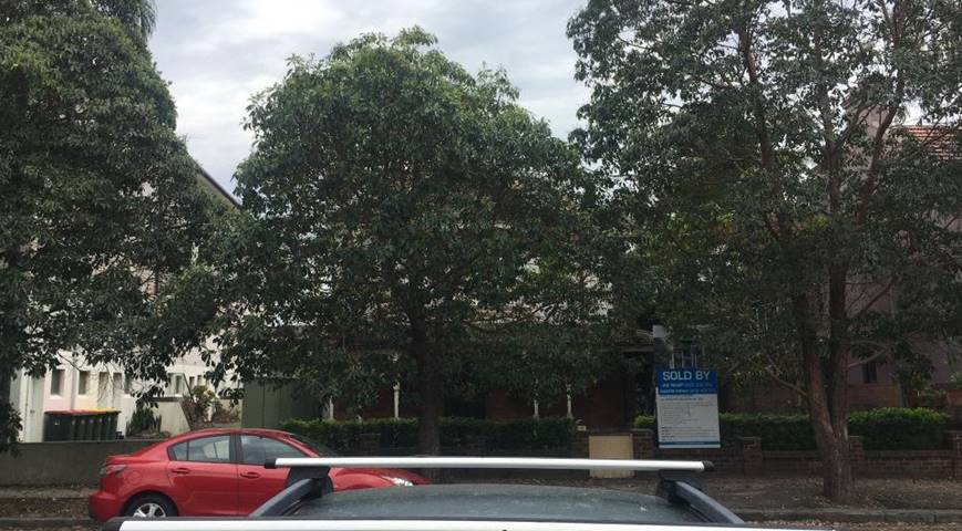
Photo 1: Street view of subject site and neighbouring properties at left 17 Carlton Street containing a four storey walk up flat building and at right No. 7 Carlton Street a two-storey terrace house.
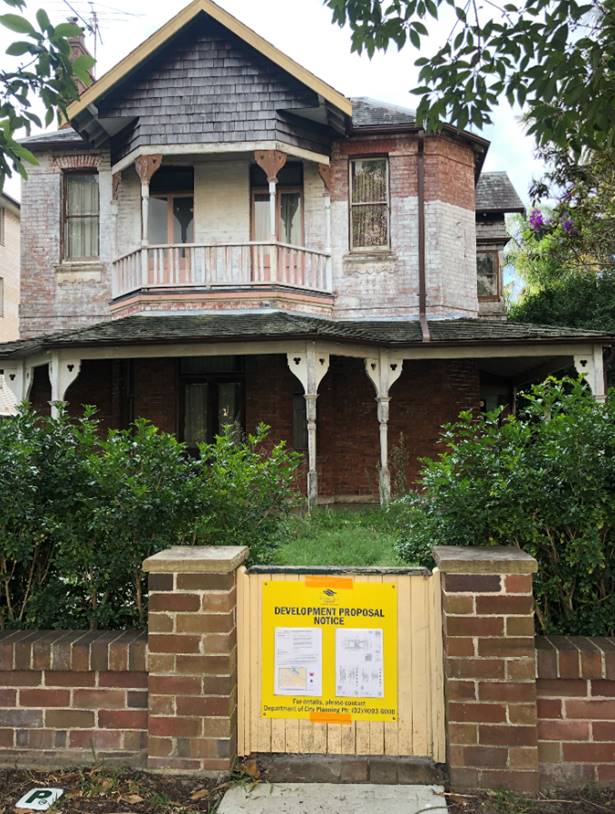
Photo 2: Existing building on the subject site.
4. Background History
The original DA was determined by the Randwick Local Planning Panel on 22 November 2018.
The approved development is primarily related to making amendments to the fourth storey of the approved development under DA/304/2017. The amendments to the development sought floor area to replace open space within the envelope of the roof thus converting the fourth storey 2 studio units into a three-bedroom unit.
DA/304/2017 was approved on 8 January 2018, under Section 34(3) of the Land and Environment Court Act 1979, approved the demolition of all existing structures and construction of a four-storey residential flat building containing 1 x 1 bedroom dwelling, 6 x 2 bedroom dwellings and 1 x 3 bedroom dwelling for a total of 8 dwellings, common open space, basement parking for 10 vehicles, 1 motorcycle and bicycle storage and associated landscape works.
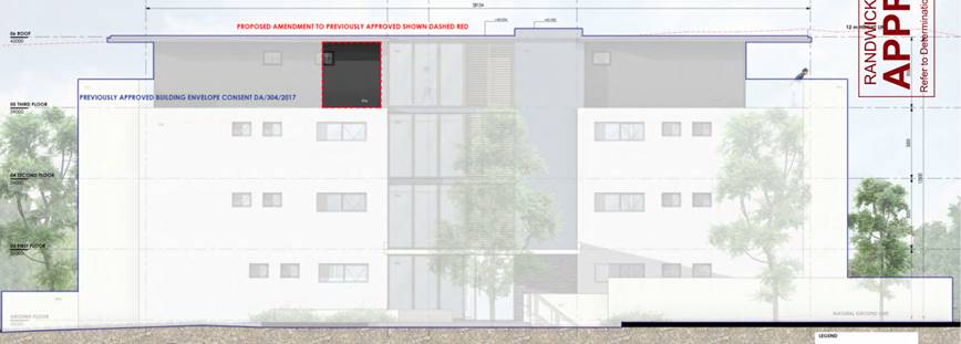
East elevation plan as approved under DA/92/2018.
A S4.55(2) application currently under simultaneous assessment is sought to modify DA/304/2017 to:
· Increase the floor levels at ground by 100mm to 3.1m, first floor by 50mm to 3.05m and second floor by 50mm to 3.05m.
· Reposition Internal corridor link (including Stairs, lift and services room) 300mm further west (from 3.2m to 3.5m from eastern side boundary).
· Changes to window openings
· Repositioning of courtyard fence between communal open space and unit 1
· No change to building footprint except breezeway
· Deletion of a car space in basement
5. Proposal
The modifications to the amending DA include:
· Internal layout of Unit L3-01 revised to enhance internal amenity and functionality,
· Window (east facing) size to fourth storey bedroom 3 increased providing more natural light and ventilation (1600mm sill height)
· Window (north facing) to fourth storey combined laundry/study repositioned to suit reconfiguration
· Roof and internal corridor link (including Stairs, lift and services room) repositioned 300mm further west (from 3.2m to 3.5m from eastern side boundary) to correspond with repositioning of levels below (as proposed under S4.55(2) of the Act for separate concurrent modification “A” of DA/304/2017). No change to approved floor space ratio is proposed.
· Roof level raised by between 300mm for outer roof (RL42.00 to RL42.30) and inner hub by 300mm (from RL42.305 to RL42.65), apart from the central internal corridor link portion of the building, to provide increased floor to floor height for fourth storey by 100mm and 200mm over three levels below (as proposed under separate modification of DA/304/2017/A).
· Height of lift overrun increased by 700mm.
6. Section 4.55 Assessment
Under the provisions of Section 4.55 of the Environmental Planning and Assessment Act, 1979 (the Act), as amended, Council may only agree to a modification of an existing Development Consent if the following criteria have been complied with:-
1. it is satisfied that the development to which the consent as modified relates is substantially the same development as the development for which the consent was originally granted and before that consent as originally granted was modified (if at all), and
2. it has consulted with any relevant public authorities or approval bodies, and
3. it has notified the application & considered any submissions made concerning the proposed modification
An assessment against the above criteria is provided below:
1. Substantially the Same Development
The proposed modifications are not considered to result in a development that will fundamentally alter the originally approved development.
2. Consultation with Other Approval Bodies or Public Authorities:
The development is not integrated development or development where the concurrence of another public authority is required.
3. Notification and Consideration of Submissions:
The owners of adjoining and likely affected neighbouring properties were notified of the proposed development in accordance with the Randwick Comprehensive DCP 2013. The following submissions were received as a result of the notification process:
· 3/11-17 Carlton Street, Kensington x 2
· 24 Doncaster Avenue, Kengsinton
· 9 cottenham Avenue, Kensington
· 15 Cottenham Avenue, Kengsinton
· 14 Roma Avenue Kensington
· Email (KC)
· 64 Brook Street Coogee
· Email (PW)
· 49 Robertson Road, Centennial Park
· Email (TC)
· Randwick Heritage Action Group
· 9/152 Brook Street
· Resident Abbotford Street Street, Kensington (EH)
· 15 Virginia Street, Kensington
· 8 Amour Ave Maroubra
· Email (HB)
· 16 Abbotford Street Street, Kensington
· 12/3-5 Houston Road, Kensington
· Resident of Elizabeth Bay
|
Issue |
Comment |
|
The existing building is a grand home with great architectural features, it reflects culture and history and should be retained and protected. Its demolition for a flat building lacking this character will lose its historical features for locals and future generations. |
The existing building located at No. 9 Carlton Street whilst not a heritage item contains elements of historical value and as stated in the amending DA condition 2 was imposed under the parent DA/304/2017 requiring an archival recording of the property to be presented to Council and the Local History Collection of Randwick City Library. Development consent has been granted for demolition however a condition is included in DA/304/2017 requiring an archival recording of the historical value of the building for future reference.
Consent has been granted for demolition of existing building and development for a residential flat building. |
|
If the proposal were rejected there could remain an opportunity to explore how this item of our heritage might complement the innovative K2K development plan. |
As noted, this site is approved for redevelopment. It is noted that the latest iteration of the K2K draft DCP contains strengthened controls for heritage items and contributory buildings across both town centres based on heritage consultant studies and the Burra Charter which is referenced as heritage best practice. Notwithstanding, it is noted that the subject site is not located in the K2K area and significant distance away. |
|
The history of the site shows a refusal for a flat building on this site in 1973 which is the right decision |
Each application is assessed on its merits and it was considered in the assessment of the original application which approved the demolition and development for medium density form of development. In this respect, a condition requiring an archival recording of the building’s elements of historical value was imposed by the Court. |
|
The proposed building will place a burden on infrastructure. |
The approved development for a residential flat building is a form of medium density development that is permissible and envisage din the R3 medium density zone. |
|
The proposed boarding house is not appropriate and huge drop in overseas students makes this development redundant |
The approved development is for a residential flat building and not specifically for a boarding house (student accommodation) and designed to cater for apartment living. |
|
The proposed development causes overshadowing is too bulky and generally detract from the amenity of the area. |
The proposed modifications cause additional overshadowing however it is within the level of overshadowing anticipated by a medium density form of development. |
|
It’s not understood why this building was not heritage listed years ago. The lack of meaningful heritage protection is concerning to the public. |
Reviews of heritage significance and conservation are conducted by Council from time to time. For instance, as indicated in the previous report:
Council’s original heritage study was carried out in the late 1980s and this assessment formed the basis for the listing contained in the Heritage Schedule that was adopted with a new Local Environmental Plan (LEP) gazetted in 1993. Subsequent heritage reviews in 1994 and 2012 resulted in more properties added to the Heritage Schedule and the extensive West Kensington heritage conservation area were added in 1998. As well as the West Kensington heritage conservation area, there are over 50 heritage items within the suburb of Kensington.
Additions or deletions from the Randwick LEP Heritage Schedule or changes to heritage conservation areas are made following detailed investigations carried out by a heritage professional, in accordance with established heritage significance criteria, including historical and aesthetic significance. Generally, only the most intact examples of buildings of a particular period are listed. As noted, development consent already been granted for the demolition and development of this building. |
|
Surely there are several possibilities to save this house while still fulfilling the wish to develop the site where the existing house should be incorporated within the development plans. |
The proposal does not seek to retain the existing house and under the EP&A Act it is beyond the scope of this application to require or allow for a modification that is substantially different to that which original consent was granted. |
|
The removal of the visitor parking space is objected to |
S4.55 for DA/304/2017/A is seeking this modification. Notwithstanding, the proposal provides the correct number of visitor parking spaces required for the development as amended by DA/92/2018 which reduced the DCP requirements for visitor parking down to 1 for the 7 units. |
|
The increase in the floor level and height is strongly objected to as it will cast a greater shadow on our building on eastern elevation of No. 11-17 Carlton Street. |
The increase in height of the building by 300mm is considered acceptable as it provides for compliant floor to ceiling heights required by the ADG and also will not result in any adverse impacts on the neighbouring properties beyond that which occur by a compliant development. |
|
The proposed development will result in additional adverse privacy impacts on eastern elevation of No. 11-13 Carlton Street. |
The proposed increase in height is not anticipated to result in any appreciable difference in privacy impacts on the western neighbours property. |
7. Relevant Environment Planning Instruments
7.1 SEPP 65 Design Quality Residential Flat Buildings
SEPP 65 aims to promote quality design of Residential Flat Buildings (RFB’s). The proposed modifications are subject to the policy as it is development for a residential flat building being 3 storeys and more in height containing four or more dwellings. Council’s Design Excellence Panel (DEP) commented on the original design and was generally supportive of the proposal, In this respect, the proposed modifications do not materially alter the outcome of the amending or original scheme noting the proposed modifications seek compliance with the minimum floor to ceiling heights in the ADG.
The key issues section of this report considers the overshadowing impact from the proposed modifications in more detail with particular regard to the proposed increase in height in comparison with a compliant height standard.
7.2 Randwick Local Environmental Plan 2012 (LEP)
The site is zoned R3 Medium Density Residential under Randwick Local Environmental Plan 2012 and the proposed modifications are permissible with consent.
Objectives of the zone:
· To provide for the housing needs of the community within a medium density residential environment.
· To provide a variety of housing types within a medium density residential environment.
· To enable other land uses that provide facilities or services to meet the day to day needs of residents.
· To recognise the desirable elements of the existing streetscape and built form or, in precincts undergoing transition, that contribute to the desired future character of the area.
· To protect the amenity of residents.
· To encourage housing affordability.
· To enable small-scale business uses in existing commercial buildings.
The proposed modification to the upper most level remain consistent with the specific objectives of the zone in that the proposed activity and built form will not be altered appreciably beyond that originally approved and will continue to contribute to the desired future character of the area whilst at the same time reasonably protecting the amenity of residents.
The following development standards in the RLEP 2012 apply to the proposal:
|
Clause |
Development Standard |
Proposal |
Compliance (Yes/No) |
|
Cl 4.4: Floor space ratio (max) |
0.9:1 (approved 0.95:1) |
No change |
NA |
|
Cl 4.3: Building height (max) |
12m
12.83m approved for the lift overrun in DA/304/2017.
DA/92/2018 approved a height of 12.24m as it related to localised additional floor area within the approved roof. |
See figure below:
13.13m (300mm increase) lift overrun above existing ground level. |
No, see merit assessment below. |
|
Clause 5.10 |
The site is located in the vicinity of a heritage item at 2-4 Carlton Street. |
Increase in height of the development by 300mm |
See assessment below. |
Height of building
The proposed development seeks additional 300mm to the height of the development by way of adding 300mm to the lift overrun and increase in floor levels by way of 100mm to the ground level, 50mm to Levels 1 and 2 and 100mm to the top most level 3 (fourth storey).
The proposed additional height across the development results in a maximum height of building for the following parts of the development:
· Lift overrun to 13.13m (43.05 – 29.92)
Rear outer edge of roof:
· North western corner to 12.10m
· North eastern corner to 12.14m
Front outer edge of roof:
· South western corner to 12.48m
· South eastern corner to 12.55m
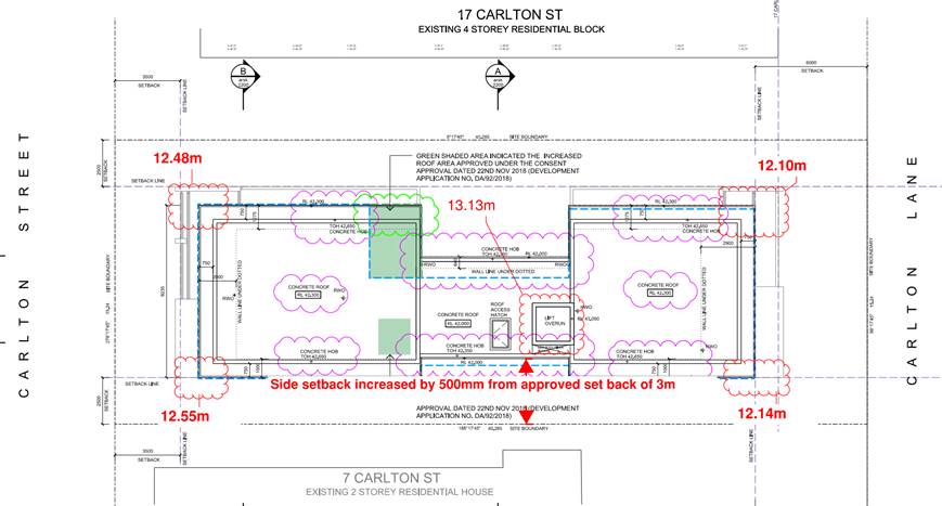
Figure 1: proposed roof plan showing proposed height of the lift overrun and outer edges of the roof.
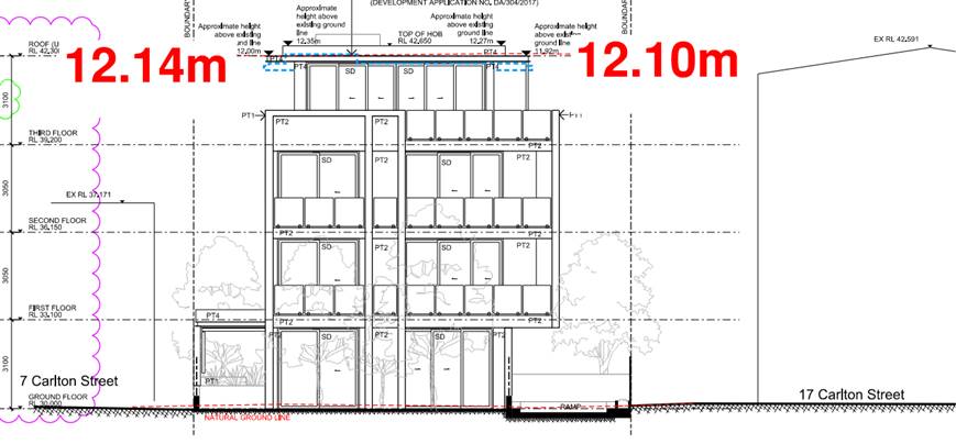
Figure 2: northern rear elevation showing height of the proposed outer edge of the roof
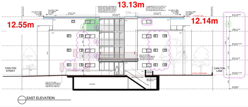
Figure 3: Eastern elevation showing the building hieghts as sought above existing gorund levels.
A formal Clause 4.6 variation is not strictly applicable for Section 4.55 modifications. The relevant judgments (originating with North Sydney Council v Michael Standley & Associates Pty Ltd [1998] NSWSC 163) say that section 4.55 is a ‘free-standing provision’, meaning that “a modification application may be approved notwithstanding the development would be in breach of an applicable development standard were it the subject of an original development application”. Therefore, a section 4.55 modification application can be approved even though it would contravene a development standard. Section 4.55 (3) still requires the consent authority to take into consideration the matters referred to in Section 4.15, which in turn include the provision of any environmental planning instrument. Therefore, an assessment against the objectives of the Standard in Clause 4.3 hieght of buildings and of the R3 zone is carried out below to demonstrate consistency with the Clause 4.6 provision.
Objectives of the height of buildings standard
(a) to ensure that the size and scale of development is compatible with the desired future character of the locality,
The proposed 300mm additional height is relatively minor with the most pronounced overall height occurring for the lift overrun in the middle of the site which is well away from the streetscape frontages along Carlton Street and Carlton Lane. Whilst the outer edges of the roof also exceed the maximum height standard these are less pronounced, and the size and scale of the development is considered to remain compatible with the desired future character of the locality for the following reasons:
· The proposed three storey scale with a fourth storey contained within a reduced floor plate is consistent with the envelope envisaged by the standards in the RLEP and RDCP provisions for medium density residential development. The applicant has demonstrated that there is no appreciable difference between a compliant height at the rear and that caused by the proposed development whereby this outcome has been achieved by providing greater side and rear setbacks at the upper level than the minimum under the RDCP for medium density development.
· The upper level has a built form that remains subservient to the levels below.
· The proposal more easily provides ADG and DCP compliant floor to ceiling heights
(b) to ensure that development is compatible with the scale and character of contributory buildings in a conservation area or near a heritage item,
The nearest heritage item is located at an adjacent corner to the south west at No. 2-4 Carlton Street. The proposed additional height is minor and for the reasons given above it is not considered that the increase in height by 300mm will be perceptible when considered in the context of views along the streetscape or within the visual catchment of the Heritage item. The development site is located a substantial distance away from the heritage conservation area to east.
(c) to ensure that development does not adversely impact on the amenity of adjoining and neighbouring land in terms of visual bulk, loss of privacy, overshadowing and views.,
In terms of visual bulk, the proposed increase in height above the height standard is largely imperceptible from a human scale. Notwithstanding, some visual relief is provided by the modification seeking to setback further from the eastern side the central breezeway connecting the front and rear built forms.
With regards to privacy, the proposed increase in floor levels has no appreciable adverse impacts on the privacy of neighbouring properties with particular regard to their habitable room windows or areas of private open space.
With regards to overshadowing, there will be additional overshadowing to the each of the eastern and western side neighbours at No. 7 Carlton Street and 11-17 Carlton Street respectively, there is no appreciable difference between the overshadowing that would be caused by a scheme that complied with the maximum height of buildings standard which is largely a consequence of the increased setbacks of the upper level.
With regards to views, it is not considered that the increased height will result in any appreciable difference in view impact between that caused by the existing approved development. Moreover, a walk around the area does not reveal any views of a high-quality that would be impacted by the proposed increase in height.
Overall, it is considered that the proposed modifications will continue to satisfy the objectives of the height of buildings standard.
Objectives of the R3 zone
· To provide for the housing needs of the community within a medium density residential environment.
· To provide a variety of housing types within a medium density residential environment.
· To enable other land uses that provide facilities or services to meet the day to day needs of residents.
· To recognise the desirable elements of the existing streetscape and built form or, in precincts undergoing transition, that contribute to the desired future character of the area.
· To protect the amenity of residents.
· To encourage housing affordability.
· To enable small-scale business uses in existing commercial buildings.
The proposed modifications remain consistent with the specific objectives of the zone in that the proposed activity and built form will not be altered beyond that approved and will continue to contribute to the desired future character of the area whilst reasonably protecting the amenity of residents subject to appropriate conditions. The proposal provides 2.7m floor to ceiling heights that are achievable through standard construction rather than relying on engineered solutions that both have the potential to not be adhered and also may not be suitable for future occupants.
Therefore, having regard to an assessment against the objectives of the standard and the zone it is considered that, the proposed modifications seeking an increase in height of the development will be in the public interest and are supported.
Heritage Conservation
The site is not a heritage item or located in a Heritage Conservation Area, however a heritage item is located on the opposite side of the street at No. 2-4 Carlton Street requiring consideration under Clause 5.10 of the RLEP. The proposed development is primarily associated with modifications to an approved development with no significant changes that would alter the human or streetscape scale of the built form.
Overall, having regard to the approved part 3 part 4 storey scale and the distance from the heritage item it is considered that the proposed modifications aren’t intrusive or unreasonable and the relevant objectives in the RLEP that seek to minimise the impact of development on heritage conservation in Randwick will be satisfied.
8. Key Issues
· Building Height
The proposed development as noted above exceeds the maximum height of buildings standard and it is considered that the proposed height increase is acceptable for the reasons outlined above and the assessment contained in this report.
· Randwick Development Control Plan 2013
External wall height
The RDCP states that where a development is subject to a 12m maximum height of buildings standard, a 10.5m maximum external wall height control (measured from the underside of the eaves to the adjacent ground level) applies. The proposed variation to the external wall heights vary across the site in a similar fashion to the roof form in that it is sought to be increased by 300mm. Under the RDCP, a variation to a control requires an assessment against the associated objectives which are stated as follows:
Objectives:
· To ensure that the building form provides for interesting roof forms and is compatible with the streetscape.
· To ensure ceiling heights for all habitable rooms promote light and quality interior spaces.
· To control the bulk and scale of development and minimise the impacts on the neighbouring properties in terms of overshadowing, privacy and visual amenity.
The proposed external wall heights satisfy the above objectives for the following reasons:
· To ensure that the building form provides for interesting roof forms and is compatible with the streetscape.
o In terms of the bulk and scale of the development, the proposed upper level maintains additional setbacks from the levels below that remains distinctly subservient to the main built form below presenting the top level as a pavilion. The top floor area has a smaller floor area than the footprint of the storey below thus avoiding presentation of the top level as a full storey above which is a design outcome encouraged by the Roof Design and Habitable roof form provisions in the RDCP for Medium Density Residential development.
o The modifications increase the side setback of the middle breezeway between the two main built forms which alleviates the exceedance of the wall height provisions both in relation to the streetscape and visual amenity of neighbours.
o The design maintains a variety of building materials an stepped in forms at this level relieving the visual bulk from the non-compliant areas.
· To ensure ceiling heights for all habitable rooms promote light and quality interior spaces.
o The proposal seeks to provide compliant floor to ceiling heights within a standard construction rather than relying on more costly methods of construction to achieve this outcome.
· To control the bulk and scale of development and minimise the impacts on the neighbouring properties in terms of overshadowing, privacy and visual amenity.
The impacts on the amenity of neighbouring properties such as overshadowing, visual bulk, privacy and views are considered to have been minimised as far as practical for the following reasons:
o In relation to visual amenity, the modifications don’t alter the articulation along the front, rear elevations however they do alleviate the visual bulk along eastern elevation by way of providing a slightly increased side setback for the breezeway.
o In relation to overshadowing, whilst there are additional adverse impacts on the side neighbouring properties when compared with a compliant envelope and setbacks there is relatively little difference as will be discussed in the next discussion point further below.
o In relation to privacy, the proposed modifications will satisfy the associated objectives.
o In relation to views, it is not anticipated that there are any high-quality views from neighbouring properties that will be affected by the proposed external wall heights beyond those anticipated by the applicable standard.
Overall, the proposed external wall heights are considered suitable for the site and the amenity impacts on neighbouring properties has been suitably minimised.
Overshadowing
Concerns have been raised in submission from the western side neighbour regarding overshadowing from the modification applications. The relevant applicable planning controls for overshadowing of neighbouring properties are those contained in the ADG and the RDCP. The RDCP controls is for 3 hours solar access to part of neighbouring windows and 50% of neighbouring private open space (POS) from 8am and 4pm mid-winter. The ADG control is for 2 hours of solar access to the neighbouring properties with a focus to providing it to living rooms and areas of private open space (POS) from 9am to 3pm during the winter solstice. The existing approved development does not provide these amounts of solar access due in large part to the fact that the development is located within the medium density zone and the permissible built form for medium density development usually with narrow side passageways precludes the ability to provide solar access in line with RDCP and ADG controls. An assessment is nonetheless required against the objectives of the controls with particular regard to the RDCP which seeks:
To ensure development retains reasonable levels of solar access to the neighbouring properties and the public domain.
The applicant has provided a shadow study showing the overshadowing from:
· Permissible envelope for height under the RLEP and side setback requirements under the RDCP
· Approved development
· Proposed modification and
An analysis of overshadowing is caried out below as it relates to the eastern elevation of the RFB at No. 11-13 Carlton Street and the western elevation fo the duplex at No. 7 Carlton Street.
11-17 Carlton Street
The applicant has demonstrated less overshadowing over the upper three levels of this neighbours eastern elevation when compared with shadows cast by a permissible envelope. A comparison between the approved and proposed modification however shows additional overshadowing. The additional overshadows are limited to a short 15 min time intervals and sometimes less between 8am and 9.30am to parts of kitchen and or bedroom and bathroom windows as identified in the images below.
|
Permissible envelope shadows on eastern elevation at 8am, 8.15am and 8.30am shows the fourth storey kitchen and bedroom are overshadowed at 8am with none occurring at 8.15am and beyond.
|
|
|
|
Compliant envelope overshadowing at 8.45am, 9.00am and 9.15am
|
|
The proposed modification results in additional overshadowing of the third storey bedroom window across half of its area between 8.45am and 9.00am retaining solar access to most of the window surface at 9.00am. The grey shading in this image shows the overshadowing caused by the approved development.
|
|
Compliant envelope shadows on eastern elevation at 9.30am, 9.45am and 10.00am
|
|
The proposed modification results in additional overshadowing of the 1st floor bedroom window across at 9.30am occurs for less than 15 minutes compared with the overshadowing from the approved development (grey shading).
|
No. 7 Carlton Street
|
The proposed modification results in additional overshadowing of the 1st floor bathroom and bedroom windows whereby solar access to their principle living room at ground level connected to the rear yard their principle private open space not affected by overshadowing. |
Overall, whilst the proposed modification results in additional overshadowing compared with the current approval, the additional overshadowing is very minor, it impacts on side facing windows which are difficult to protect, particularly in the urban context, and it is generally considered that the non-compliant height of the development is largely a consequence of the localised low points within the site rather than a result of inappropriate approach to building design having regard to the RDCP provisions that seek to control medium density development.
9. Referral comments
No referral required for this modification.
10. Section 4.15 Assessment
The site has been inspected and the application has been assessed having regard to Section 4.15 of the Environmental Planning and Assessment Act, 1979, as amended.
|
Section 4.15 ‘Matters for Consideration’ |
Comments |
|
Section 4.15 (1)(a)(i) – Provisions of any environmental planning instrument |
State Environmental Planning Policy No 65—Design Quality of Residential Apartment Development
A design verification statement has been provided by a qualified designer and the development (as amended) will remain compliant with the SEPP and associated Apartment Design Guide.
State Environment Planning Policy (Building Sustainability Index: BASIX) 2004.
Clause 55A of the EP & A Regulation requires that a new BASIX certificate be lodged for amended plans or where a section 4.55 modification makes a material change to the BASIX commitments as originally approved.
The applicant has submitted a new BASIX certificate. The plans have been checked with regard to this new certificate and they are consistent with the requirements indicated for DA stage. Standard conditions of consent requiring the continued compliance of the development with the SEPP:BASIX were included in the original determination.
Randwick Local Environmental Plan 2012
The proposed modifications are ancillary to the approved development, which will remain substantially the same. The development remains consistent with the general aims and objectives of the RLEP 2012.
|
|
Section 4.15(1)(a)(ii) – Provisions of any draft environmental planning instrument |
Nil. |
|
Section 4.15(1)(a)(iii) – Provisions of any development control plan |
The development remains compliant with the objectives and controls of the Randwick Comprehensive DCP 2013. |
|
Section 4.15(1)(a)(iiia) – Provisions of any Planning Agreement or draft Planning Agreement |
Not applicable. |
|
Section 4.15(1)(a)(iv) – Provisions of the regulations |
The relevant clauses of the Regulations have been satisfied. |
|
Section 4.15(1)(b) – The likely impacts of the development, including environmental impacts on the natural and built environment and social and economic impacts in the locality |
The proposed modifications have responded appropriately to the relevant planning controls and will not result in any significant adverse environmental, social or economic impacts on the locality. |
|
Section 4.15(1)(c) – The suitability of the site for the development |
The site has been assessed as being suitable for the development in the original development consent.
The modified development will remain substantially the same as the originally approved development and is considered to meet the relevant objectives and performance requirements in the RDCP 2013 and RLEP 2012. Further, the proposed modifications will not adversely affect the character or amenity of the locality.
Therefore, the site remains suitable for the modified development. |
|
Section 4.15(1)(d) – Any submissions made in accordance with the EP&A Act or EP&A Regulation
|
The issues raised in the submissions have been addressed in this report. |
|
Section 4.15(1)(e) – The public interest |
The proposal will continue to promote the objectives of the zone and will not result in any significant adverse environmental, social or economic impacts on the locality. Accordingly, the proposal is considered to be in the public interest. |
11. Conclusion
The application is recommended for approval for the following reasons:
a) The proposed modifications are considered to result in a development that is substantially the same as the previously approved development.
b) The modified development will not result in significant adverse environmental impacts upon the amenity and character of the locality.
Nil
Responsible officer: Louis Coorey, Senior Environmental Planning Officer