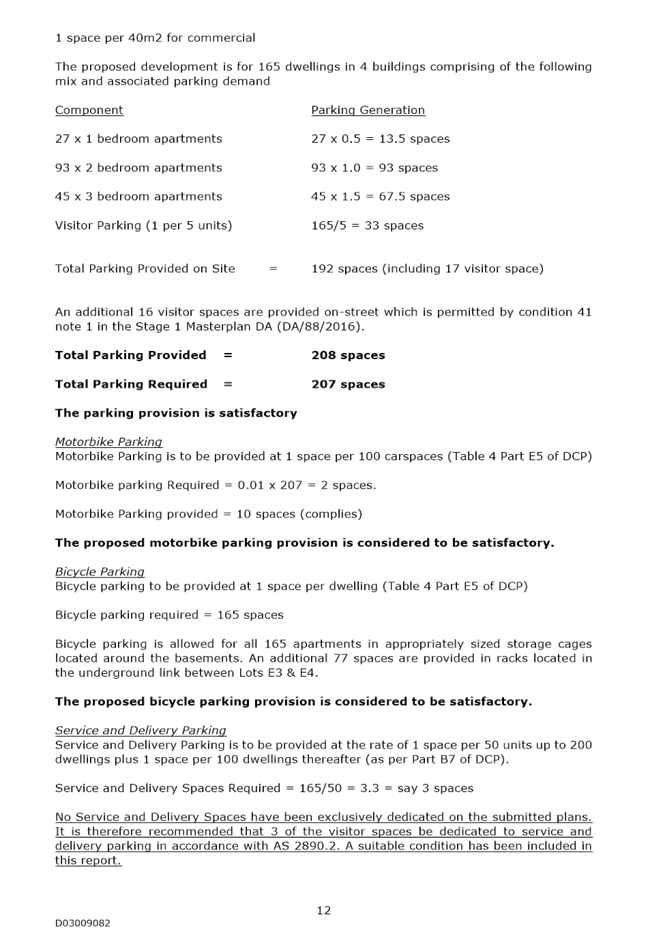
Planning Committee Meeting
BUSINESS PAPER
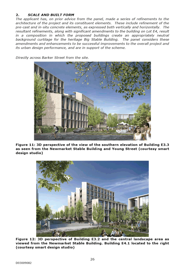
Tuesday 14 November 2017
Administrative Centre 30 Frances Street Randwick 2031
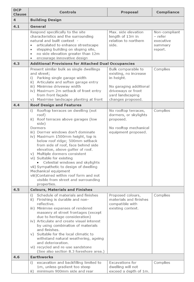
Telephone: 1300 722 542
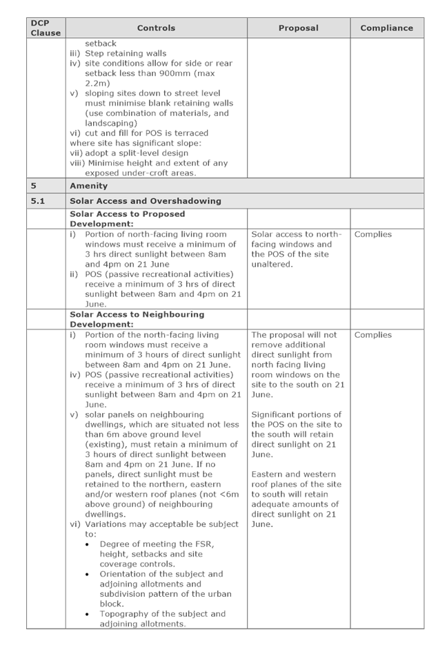
Fax: 02 9319 1510
Planning Committee Meeting
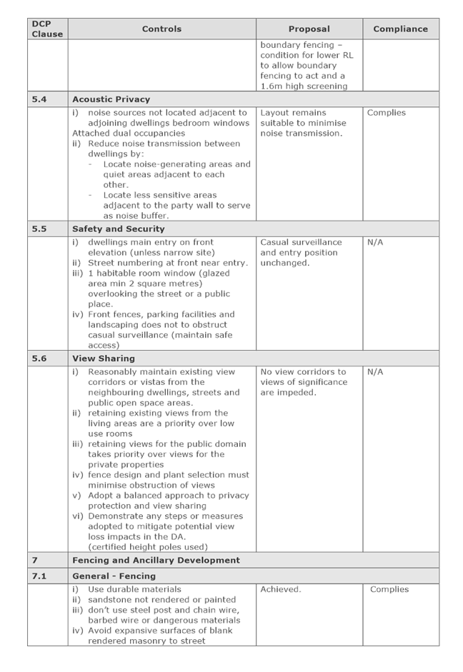
BUSINESS PAPER
Tuesday 14 November 2017
Administrative Centre 30 Frances Street Randwick 2031
Telephone: 1300 722 542
Fax: 02 9319 1510
Planning Committee 14 November 2017

Notice is hereby given that a Planning Committee Meeting of the Council of the City of Randwick will be held in the Council Chamber, First Floor, 90 Avoca Street Randwick on Tuesday, 14 November 2017 at 6:00 p.m.
Committee Members: The Mayor L Shurey, Andrews, Bowen (Deputy Chairperson), Da Rocha, D’ Souza, Hamilton, Luxford, Matson, Neilson, Parker, Roberts, Said, Seng, Stavrinos (Chairperson) and Veitch
Quorum: Eight (8) members
NOTE: At the Extraordinary Meeting held on 28 September 2004, the Council resolved that the Planning Committee whose membership consists of all members of the Council be constituted as a committee with full delegation to determine matters on the agenda.
Planning Matters
Apologies/Granting of Leave of Absences
Confirmation of the Minutes
Planning Committee Meeting - 8 August 2017
Declarations of Pecuniary and Non-Pecuniary Interests
Address of Committee by Members of the Public
Privacy warning;
In respect to Privacy & Personal Information Protection Act, members of the public are advised that the proceedings of this meeting will be recorded for the purposes of clause 69 of Council’s Code of Meeting Practice.
Urgent Business
Development Application Reports (record of voting required)
In accordance with Section 375A of the Local Government Act, the General Manager is required to keep a register of Councillor voting on planning matters. Planning matters are any decisions made in the exercise of a function of a council under the EP&A Act and include decisions relating to a development application, an environmental planning instrument, a development control plan or a development contribution plan under that Act. In addition, Randwick City Council has resolved (22 July 2008) that its register of voting include the voting on all tender matters.
D75/17 3 Seaview Street, Clovelly (DA/44/2017) (Deferred)................................ 1
D76/17 1 Keating Street, Maroubra (DA/445/2017)............................................. 55
D77/17 1 Keating Street, Maroubra (DA/549/2017)............................................. 61
D78/17 2-18 Tunstall Avenue, Kensington (DA/334/2017)..................................... 65
D79/17 31 Torrington Road, Maroubra (DA/281/2017)......................................... 95
D80/17 299 Storey Street, Maroubra (DA/493/2017)......................................... 101
D81/17 213 Bunnerong Road, Maroubra (DA/237/2017)..................................... 125
D82/17 4-6 Grosvenor Street, Kensington (DA/166/2017).................................. 143
D83/17 31 Holmes Street, Maroubra (DA/318/2015/A)....................................... 157
D84/17 10 Seaside Parade, South Coogee (DA/54/2017).................................... 163
D85/17 2/97-99 Albion Street, Randwick (DA/344/2017).................................... 167
D86/17 12 Vicar Street, Coogee (DA/333/2017)............................................... 175
D87/17 70-82 Belmore Road Randwick (DA/488/2017)....................................... 181
D88/17 4/199-203A Malabar Road, South Coogee (DA/153/2015/A)..................... 187
D89/17 81-85 Frenchmans Road, Randwick (DA/599/2008/B)............................. 197
D90/17 512 Bunnerong Road, Matraville (DA/335/2015/A).................................. 205
D91/17 309-311 Bunnerong Road, Maroubra (DA/827/2008/B)............................ 219
D92/17 185 Boyce Road, Maroubra (DA/847/2016/A)........................................ 225
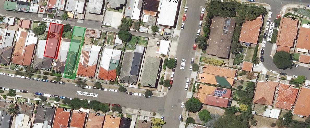
D93/17 15 Stewart Street, Randwick (DA/594/2017)......................................... 231
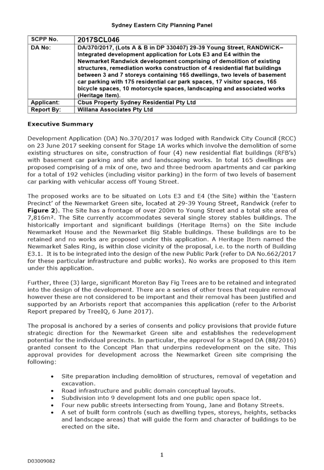
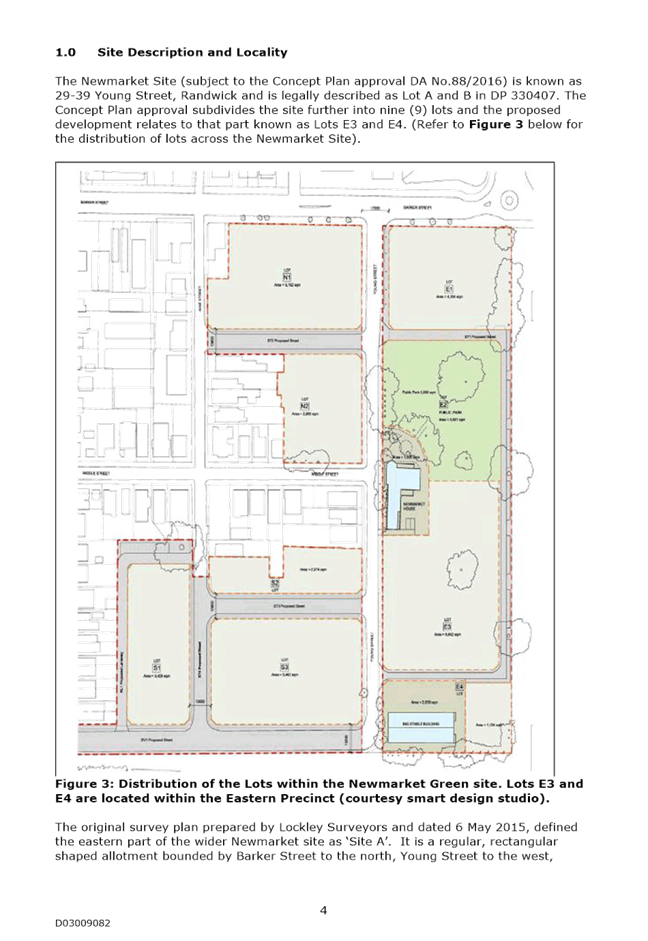
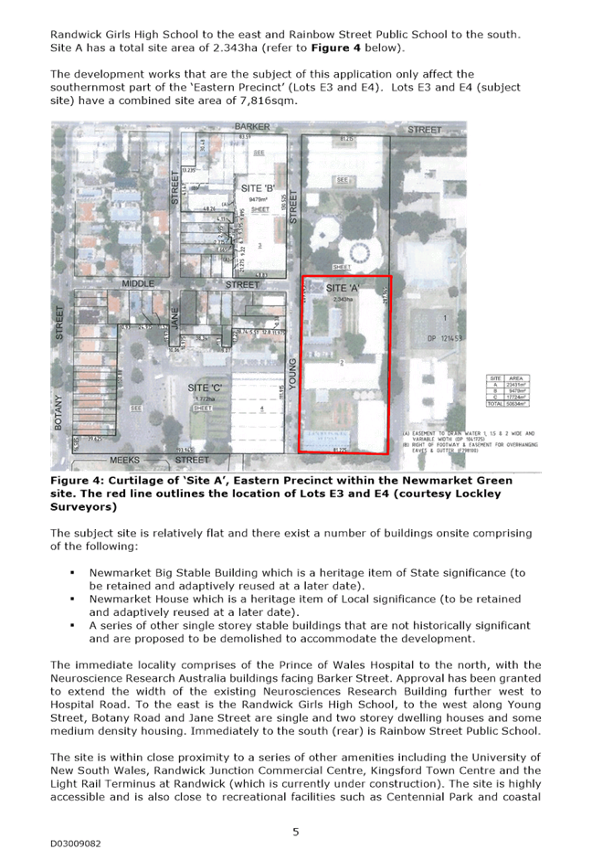
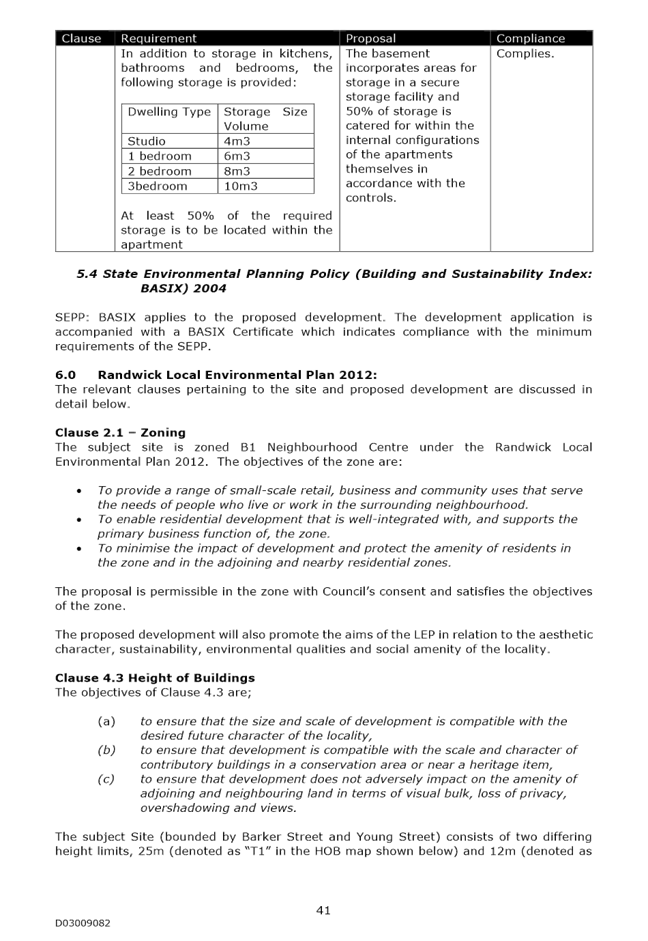
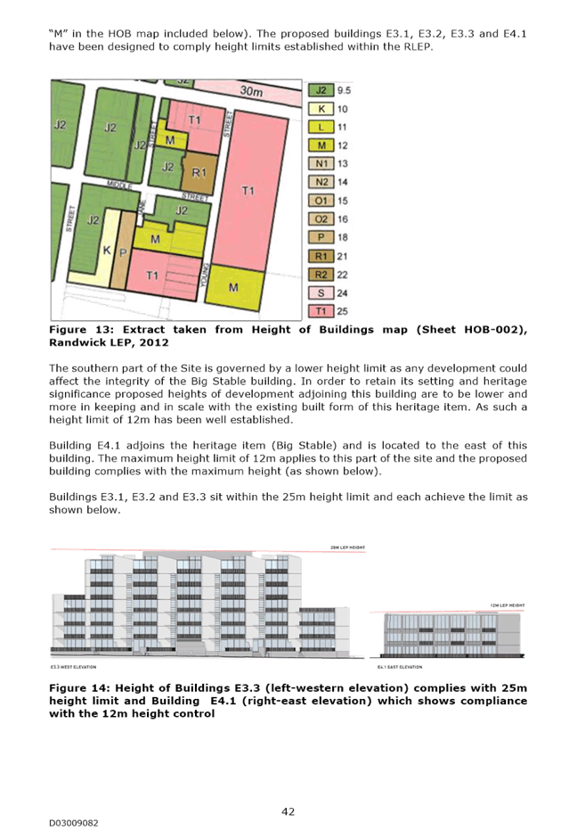
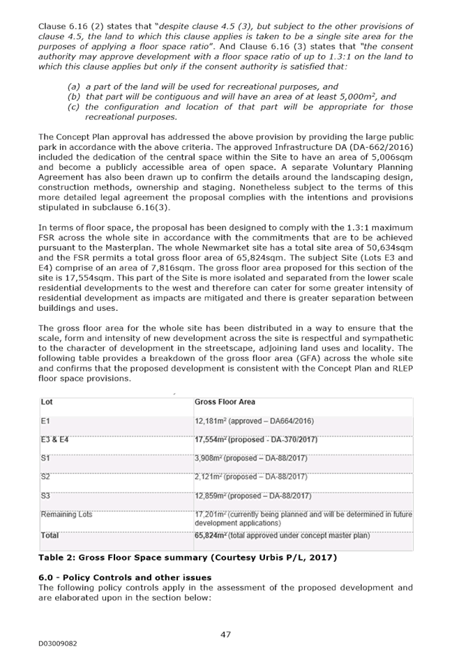
D94/17 SECPP - (Lots A & B in DP 330407) 29-39 Young Street, RANDWICK (DA/370/2017).................................................................................................... 237
Miscellaneous Reports
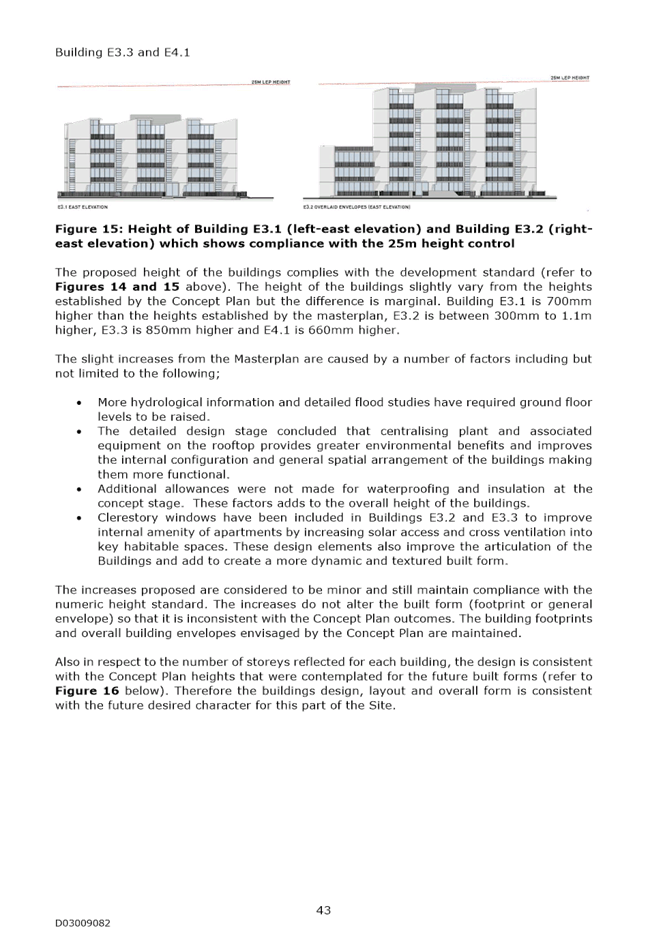
Nil
Notice of Rescission Motions
Nil
…………………………………………………….
Ray Brownlee
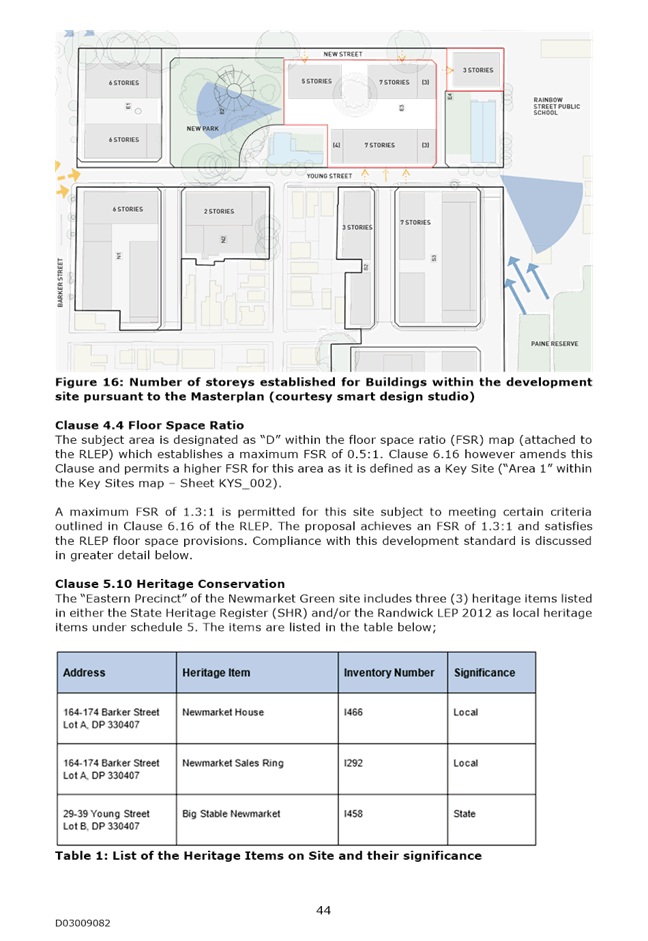
General Manager
Planning Committee 14 November 2017
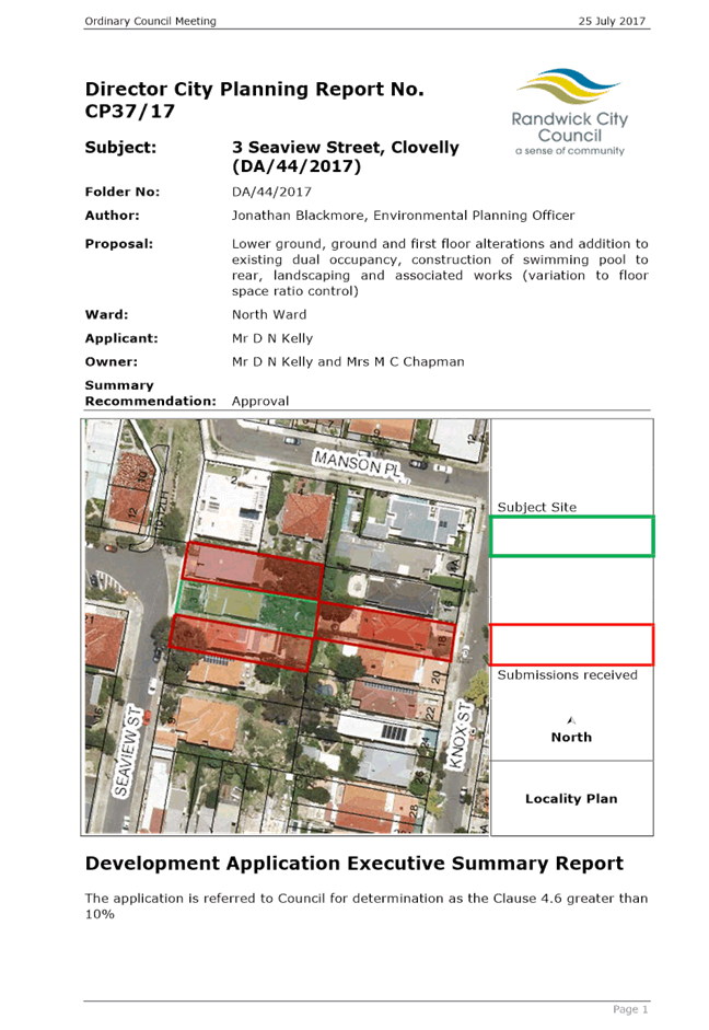
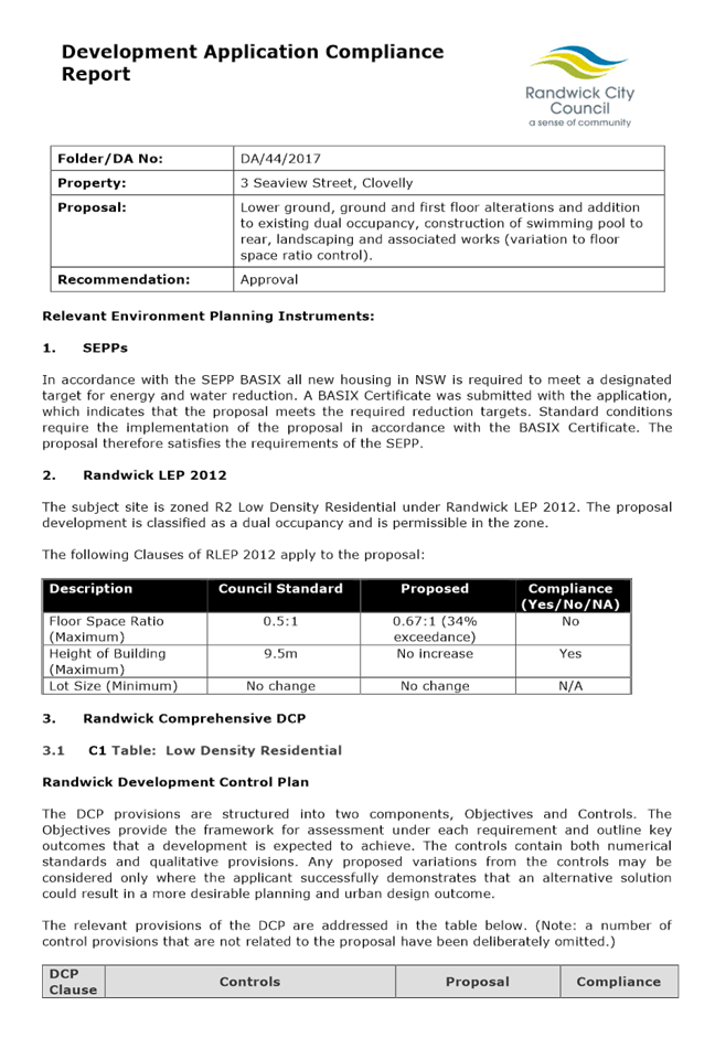
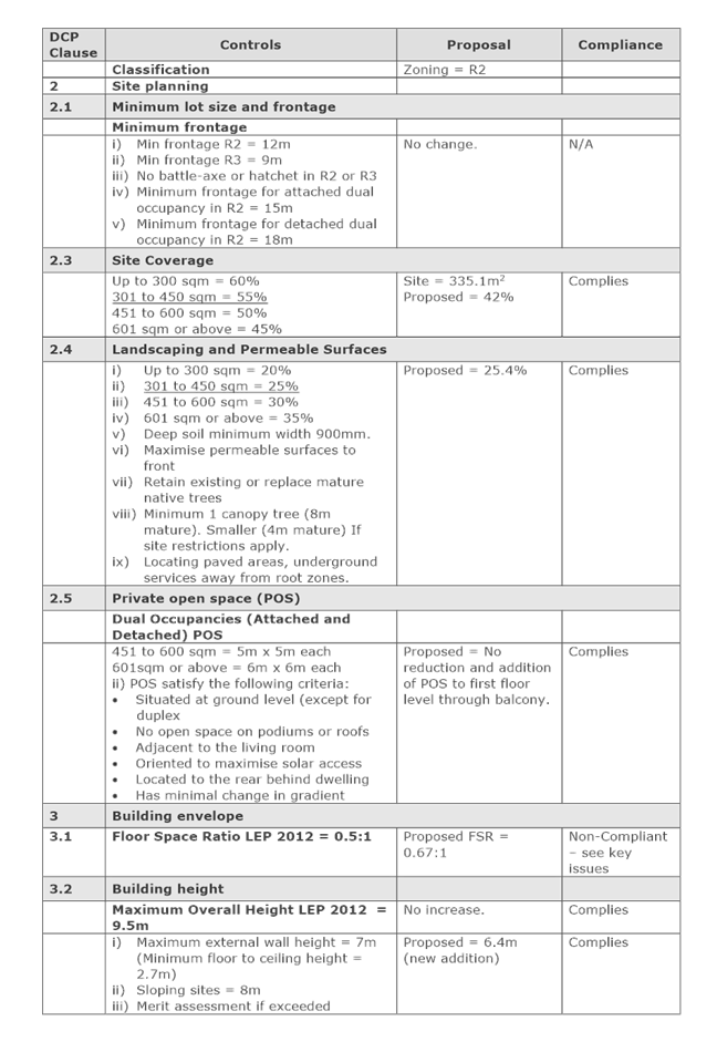
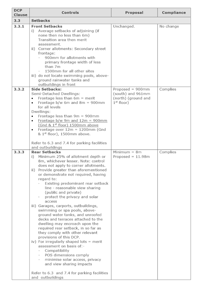
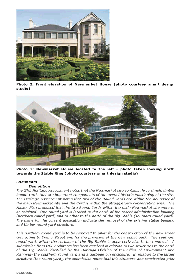
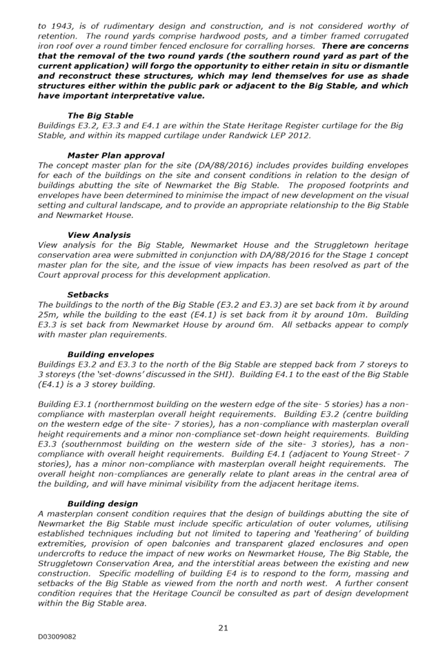
Development Application Report No. D75/17
Subject: 3 Seaview Street, Clovelly (DA/44/2017) (Deferred)
Folder No: DA/44/2017
Author: Jonathan Blackmore, Environmental Planning Officer
Proposal: Lower ground, ground and first floor alterations and addition to existing dual occupancy, construction of swimming pool to rear, landscaping and associated works (variation to floor space ratio control)
Ward: North Ward
Applicant: Mr D N Kelly
Owner: Mrs M C Chapman
Summary
Recommendation: Approval
Introduction
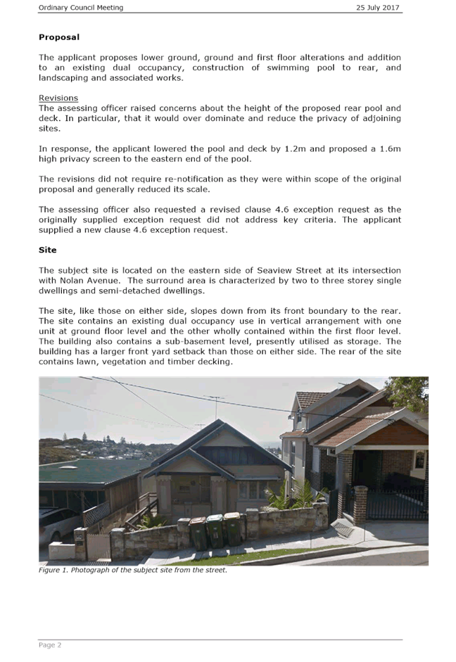
The subject application is for lower ground, ground and first floor alterations and addition to existing dual occupancy, construction of swimming pool to rear, landscaping and associated works (variation to floor space ratio control)
The application was recommended for approval and reported to the Council meeting of the 25 July 2017. At the meeting it was resolved;
“(Roberts/Smith) that this application be deferred for mediation between the applicant and objector to reach a position on the degree of loss of privacy from the balcony whilst trying to give the applicant a usable balcony area.”
Issues
Mediation Session
Mediation was held on 29 September 2017 between the applicant and objector. The following comments were provided by the Mediator:
a) That the parties have agreed to retain the hedge at the rear of No. 3 Seaview Street at the height to be advised and noted as a condition of the DA
b) In principal, have agreed to remove the screening from the ground floor level balcony upon confirmation by both owners
c) Further discussion to be undertaken by the parties regarding privacy screens from level one subject to surveying report and the establishment of sight lines that demonstrate the retention of privacy
d) The parties will report to the assessing officer.
The following comments are provided in response to the items above:
a) The applicant has now supplied a sightline diagram that demonstrates that the hedge should be at a height of 4m to prevent overlooking of the rear yard and rear windows of No. 18 Knox Street. The applicant has clarified in writing that the hedge is already at a height of 4m. A condition is recommended requiring the retention of the rear hedge at a minimum height of 4m. The condition recommending the rear privacy screens to the raised balconies off the dwelling has been removed.
b) See comments under (a), above.
c) Sightlines demonstrate that the rear hedge at a height of at least 4m will adequately preserve privacy. Privacy screening to the rear of the level one balcony is no longer required.
d) The applicant has reported to the assessing officer. No communication has been received from the objector at No. 18 Knox Street. It is considered that privacy issues have been satisfactorily resolved.
Notification
It is considered that the revisions do not require notification as the changes do not increase the built scale of the proposal, mitigate adverse impacts, and are generally within scope of what was originally notified.
Relationship to City Plan
The relationship with the City Plan is as follows:
Outcome 4: Excellence in urban design and development.
Direction 4a: Improved design and sustainability across all development.
Financial impact statement
There is no direct financial impact for this matter.
Conclusion
The applicant and objector have attended mediation. The applicant has supplied additional information, including sightline diagrams, and now propose the retention of hedging to meet the mediated outcomes, particularly in regards to privacy.
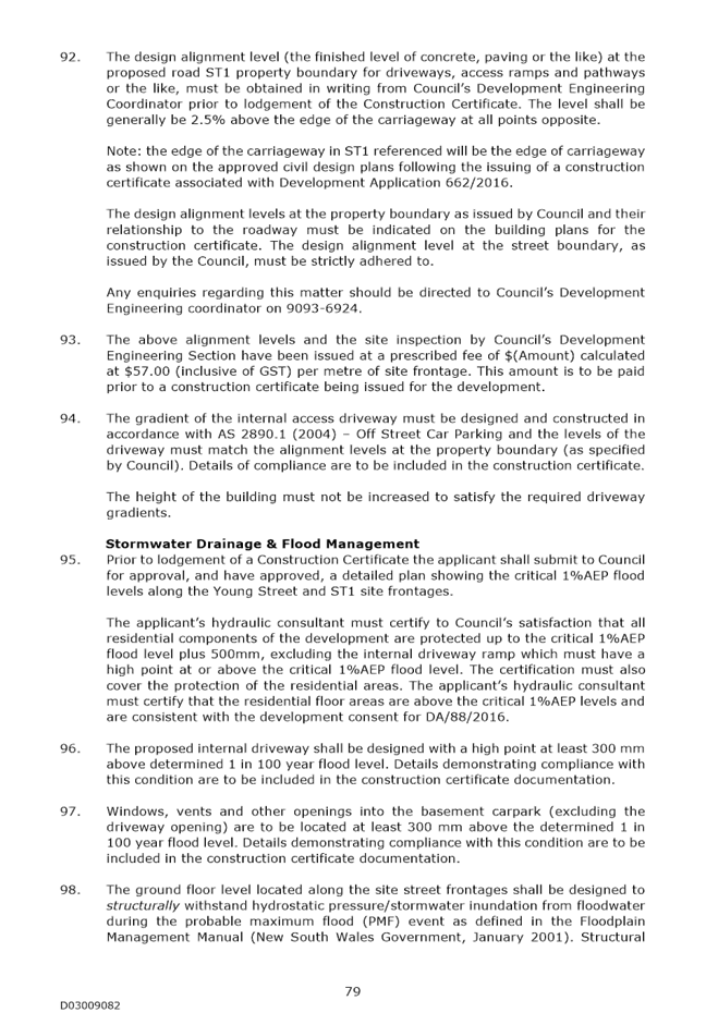
The proposal complies with the relevant assessment criteria will not result in any adverse impacts upon either the amenity of the adjoining premises or the character of the locality
The application is therefore recommended for approval subject to the attached conditions of consent.
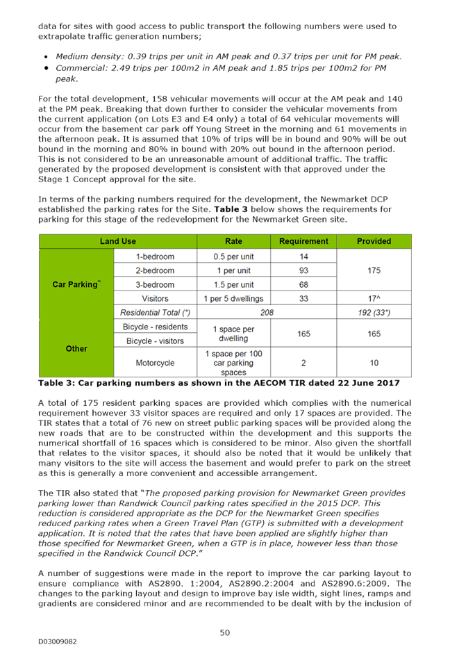
|
A. That Council supports the exception to development standards under Clause 4.6 of Randwick Local Environmental Plan 2012 in respect to non-compliance with Clause 4.4 of Randwick Local Environmental Plan 2012, relating to floor space ratio, on the grounds that the proposed development complies with the objectives of the above clause, and will not adversely affect the amenity of the locality, and that the Department of Planning & Environment be advised accordingly.
B. That Council, as the consent authority, grants development consent under Sections 80 and 80A of the Environmental Planning and Assessment Act 1979, as amended, to Development Application No. DA/44/2017 for lower ground, ground and first floor alterations and addition to existing dual occupancy, construction of swimming pool to rear, landscaping and associated works (variation to floor space ratio control), at No. 3 Seaview Street, Clovelly, subject to the following conditions:
DEVELOPMENT CONSENT CONDITIONS
GENERAL CONDITIONS The development must be carried out in accordance with the following conditions of consent.
These conditions have been applied to satisfy the relevant requirements of the Environmental Planning & Assessment Act 1979, Environmental Planning & Assessment Regulation 2000 and to provide reasonable levels of environmental amenity.
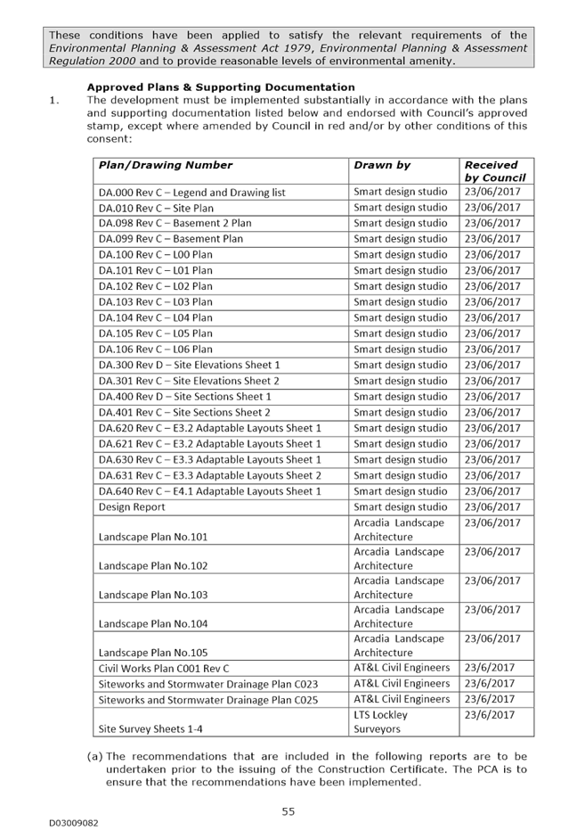
Approved Plans & Supporting Documentation 1. The development must be implemented substantially in accordance with the plans and supporting documentation listed below and endorsed with Council’s approved stamp, except where amended by Council in red and/or by other conditions of this consent:
Amendment of Plans & Documentation 2. The approved plans and documents must be amended in accordance with the following requirements:
a. The rear lawn, pool coping and deck all proposed at RL 67.50 shall match original ground levels or be lowered to not exceed RL 66.78.
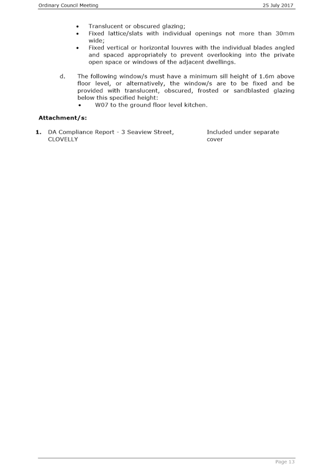
b. All privacy screens must be constructed with either: · Translucent or obscured glazing; · Fixed lattice/slats with individual openings not more than 30mm wide; · Fixed vertical or horizontal louvres with the individual blades angled and spaced appropriately to prevent overlooking into the private open space or windows of the adjacent dwellings.
c. The following window/s must have a minimum sill height of 1.6m above floor level, or alternatively, the window/s are to be fixed and be provided with translucent, obscured, frosted or sandblasted glazing below this specified height: · W07 to the ground floor level kitchen.
Eastern Boundary Hedging 3. The hedge adjacent to the full length of the eastern boundary shall be maintained indefinitely at a minimum height above ground level of 4m.
REQUIREMENTS BEFORE A CONSTRUCTION CERTIFICATE CAN BE ISSUED The following conditions of consent must be complied with before a ‘Construction Certificate’ is issued by either Randwick City Council or an Accredited Certifier. All necessary information to demonstrate compliance with the following conditions of consent must be included in the documentation for the construction certificate.
These conditions have been applied to satisfy the relevant requirements of the Environmental Planning & Assessment Act 1979, Environmental Planning & Assessment Regulation 2000, Council’s development consent conditions and to achieve reasonable levels of environmental amenity.
Consent Requirements 4. The requirements and amendments detailed in the ‘General Conditions’ must be complied with and be included in the construction certificate plans and associated documentation. Section 94A Development Contributions 5. In accordance with Council’s Section 94A Development Contributions Plan effective from 21 April 2015, based on the development cost of $291,500 the following applicable monetary levy must be paid to Council: $2,915.
The levy must be paid in cash, bank cheque or by credit card prior to a construction certificate being issued for the proposed development. The development is subject to an index to reflect quarterly variations in the Consumer Price Index (CPI) from the date of Council’s determination to the date of payment. Please contact Council on telephone 9093 6999 or 1300 722 542 for the indexed contribution amount prior to payment. To calculate the indexed levy, the following formula must be used: IDC = ODC x CP2/CP1
Where: IDC = the indexed development cost ODC = the original development cost determined by the Council CP2 = the Consumer Price Index, All Groups, Sydney, as published by the ABS in respect of the quarter ending immediately prior to the date of payment CP1 = the Consumer Price Index, All Groups, Sydney as published by the ABS in respect of the quarter ending immediately prior to the date of imposition of the condition requiring payment of the levy.
Council’s Section 94A Development Contribution Plans may be inspected at the Customer Service Centre, Administrative Centre, 30 Frances Street, Randwick or at www.randwick.nsw.gov.au.
Compliance Fee 6. A development compliance and enforcement fee of $291.50 shall be paid to Council in accordance with Council’s adopted Fees & Charges Pricing Policy, prior to the issue of a Construction Certificate for development.
Long Service Levy Payments 7. The required Long Service Levy payment, under the Building and Construction Industry Long Service Payments Act 1986, must be forwarded to the Long Service Levy Corporation or the Council, in accordance with Section 109F of the Environmental Planning & Assessment Act 1979.
At the time of this development consent, Long Service Levy payment is applicable on building work having a value of $25,000 or more, at the rate of 0.35% of the cost of the works.
Sydney Water 8. All building, plumbing and drainage work must be carried out in accordance with the requirements of the Sydney Water Corporation.
The approved plans must be submitted to the Sydney Water Tap in™ online service, to determine whether the development will affect Sydney Water’s waste water and water mains, stormwater drains and/or easements, and if any further requirements need to be met.
The Sydney Water Tap in™ online service replaces the Quick Check Agents as of 30 November 2015
The Tap in™ service provides 24/7 access to a range of services, including:
· Building plan approvals · Connection and disconnection approvals · Diagrams · Trade waste approvals · Pressure information · Water meter installations · Pressure boosting and pump approvals · Change to an existing service or asset, e.g. relocating or moving an asset.
Sydney Water’s Tap in™ in online service is available at:
The Principal Certifying Authority must ensure that the developer/owner has submitted the approved plans to Sydney Water Tap in online service.
REQUIREMENTS TO BE INCLUDED IN THE CONSTRUCTION CERTIFICATE The requirements contained in the following conditions of consent must be complied with and details of compliance must be included in the construction certificate for the development.
These conditions have been applied to satisfy the relevant requirements of the Environmental Planning & Assessment Act 1979, Environmental Planning & Assessment Regulation 2000, Councils development consent conditions and to achieve reasonable levels of environmental amenity.
Compliance with the Building Code of Australia 9. In accordance with section 80 A (11) of the Environmental Planning & Assessment Act 1979 and clause 98 of the Environmental Planning & Assessment Regulation 2000, it is a prescribed condition that all building work must be carried out in accordance with the provisions of the Building Code of Australia (BCA). Details of compliance with the BCA are to be included in the construction certificate application.
Structural Adequacy 10. Certificate of Adequacy supplied by a professional engineer shall be submitted to the certifying authority (and the Council, if the Council is not the certifying authority), certifying the structural adequacy of the existing structure to support the additions to the upper floors.
BASIX Requirements 11. In accordance with section 80A(11) of the Environmental Planning & Assessment Act 1979 and clause 97A of the Environmental Planning & Assessment Regulation 2000, the requirements and commitments contained in the relevant BASIX Certificate must be complied with.
The required commitments listed and identified in the BASIX Certificate must be included on the construction certificate plans, specifications and associated documentation, to the satisfaction of the Certifying Authority.
The design of the building must not be inconsistent with the development consent and any proposed variations to the building to achieve the BASIX commitments may necessitate a new development consent or amendment to the existing consent to be obtained, prior to a construction certificate being issued.
Stormwater Drainage 12. A surface water/stormwater drainage system must be provided in accordance with the following requirements, to the satisfaction of the Certifying Authority and details are to be included in the construction certificate:-
a) Surface water/stormwater drainage systems must be provided in accordance with the relevant requirements of the Building Code of Australia (Volume 2);
b) The surface water/stormwater must be drained and discharged to the street gutter or, subject to site suitability, the stormwater may be drained to a suitably designed absorption pit;
c) Any absorption pits or soaker wells should be located not less than 3m from any adjoining premises and the stormwater must not be directed to any adjoining premises or cause a nuisance;
d) External paths and ground surfaces are to be constructed at appropriate levels and be graded and drained away from the building and adjoining premises, so as not to result in the entry of water into the building, or cause a nuisance or damage to the adjoining premises;
e) Details of any proposed drainage systems or works to be carried out in the road, footpath or nature strip must be submitted to and approved by Council before commencing these works.
REQUIREMENTS PRIOR TO THE COMMENCEMENT OF ANY WORKS The following conditions of consent must be complied with prior to the commencement of any works on the site. The necessary documentation and information must be provided to the Council or the ‘Principal Certifying Authority’ (PCA), as applicable.
These conditions have been applied to satisfy the relevant requirements of the Environmental Planning & Assessment Act 1979, Environmental Planning & Assessment Regulation 2000 and to provide reasonable levels of public health, safety and environmental amenity.
Certification, PCA & other Requirements 13. Prior to the commencement of any building works, the following requirements must be complied with:
a) a Construction Certificate must be obtained from the Council or an accredited certifier, in accordance with the provisions of the Environmental Planning & Assessment Act 1979.
A copy of the construction certificate, the approved development consent plans and consent conditions must be kept on the site at all times and be made available to the Council officers and all building contractors for assessment.
b) a Principal Certifying Authority (PCA) must be appointed to carry out the necessary building inspections and to issue an occupation certificate; and
c) a licensed principal contractor must be appointed for the building work, or in relation to residential building work, an owner-builder permit may be obtained in accordance with the requirements of the Home Building Act 1989, and the PCA and Council are to be notified accordingly; and
d) the principal contractor must be advised of the required critical stage inspections and other inspections to be carried out, as specified by the Principal Certifying Authority; and
e) at least two days’ notice must be given to the Council, in writing, prior to commencing any works.
Home Building Act 1989 14. In accordance with section 80 A (11) of the Environmental Planning & Assessment Act 1979 and clause 98 of the Environmental Planning & Assessment Regulation 2000, the requirements of the Home Building Act 1989 must be complied with.
Details of the Licensed Building Contractor and a copy of the relevant Certificate of Home Warranty Insurance or a copy of the Owner-Builder Permit (as applicable) must be provided to the Principal Certifying Authority and Council.
Dilapidation Reports 15. A dilapidation report prepared by a professional engineer, building surveyor or other suitably qualified independent person must be submitted to the satisfaction of the Principal Certifying Authority prior to commencement of any demolition, excavation or building works, in the following cases:
· excavations for new dwellings, additions to dwellings, swimming pools or the like which are proposed to be located within the zone of influence of the footings of any dwelling, associated garage or other substantial structure located upon an adjoining premises, · new dwellings or additions to dwellings sited up to shared property boundaries (e.g. additions to a semi-detached dwelling or terraced dwellings), · excavations for new dwellings, additions to dwellings, swimming pools or the like which are within rock and may result in vibration and or potential damage to any dwelling, associated garage or other substantial structure located upon an adjoining premises, · as otherwise may be required by the Principal Certifying Authority.
The report (including photographs) are required to detail the current condition and status of any dwelling, associated garage or other substantial structure located upon the adjoining premises, which may be affected by the subject works. A copy of the dilapidation report is to be given to the owners of the premises encompassed in the report/s before commencing any works.
Construction Noise & Vibration Management 16. Noise and vibration emissions during the construction of the building and associated site works must not result in damage to nearby premises or result in an unreasonable loss of amenity to nearby residents and the relevant requirements of the Protection of the Environment Operations Act 1997 and NSW EPA Guidelines must be satisfied at all times.
Noise and vibration from any rock excavation machinery, pile drivers and all plant and equipment is to be minimised, by using appropriate plant and equipment, silencers and the implementation of appropriate noise management strategies.
Construction Site Management Plan 17. A Construction Site Management Plan must be developed and implemented prior to the commencement of any works. The construction site management plan must include the following measures, as applicable to the type of development:
· location and construction of protective fencing / hoardings to the perimeter of the site; · location of site storage areas/sheds/equipment; · location of building materials for construction; · provisions for public safety; · dust control measures; · site access location and construction · details of methods of disposal of demolition materials; · protective measures for tree preservation; · provisions for temporary sanitary facilities; · location and size of waste containers/bulk bins; · details of proposed sediment and erosion control measures; · provisions for temporary stormwater drainage; · construction noise and vibration management; · construction traffic management details.
The site management measures must be implemented prior to the commencement of any site works and be maintained throughout the works, to the satisfaction of Council.
A copy of the Construction Site Management Plan must be provided to the Principal Certifying Authority and Council prior to commencing site works. A copy must also be maintained on site and be made available to Council officers upon request.
Public Utilities 18. A Public Utility Impact Assessment must be carried out on all public utility services on the site, roadway, nature strip, footpath, public reserve or any public areas associated with and/or adjacent to the development/building works and include relevant information from public utility authorities and exploratory trenching or pot-holing, if necessary, to determine the position and level of service.
19. The applicant must meet the full cost for telecommunication companies, gas providers, Ausgrid, and Sydney Water to adjust/repair/relocate their services as required. The applicant must make the necessary arrangements with the service authority.
REQUIREMENTS DURING CONSTRUCTION & SITE WORK The following conditions of consent must be complied with during the demolition, excavation and construction of the development.
These conditions have been applied to satisfy the relevant requirements of the Environmental Planning & Assessment Act 1979, Environmental Planning & Assessment Regulation 2000 and to provide reasonable levels of public health, safety and environmental amenity during construction.
Inspections During Construction 20. The building works must be inspected by the Principal Certifying Authority, in accordance with sections 109 E (3) of the Environmental Planning & Assessment Act 1979 and clause 162A of the Environmental Planning & Assessment Regulation 2000, to monitor compliance with the relevant standards of construction, Council’s development consent and the construction certificate.
Site Signage 21. A sign must be erected and maintained in a prominent position on the site for the duration of the works, which contains the following details:
· name, address, contractor licence number and telephone number of the principal contractor, including a telephone number at which the person may be contacted outside working hours, or owner-builder permit details (as applicable) · name, address and telephone number of the Principal Certifying Authority, · a statement stating that “unauthorised entry to the work site is prohibited”.
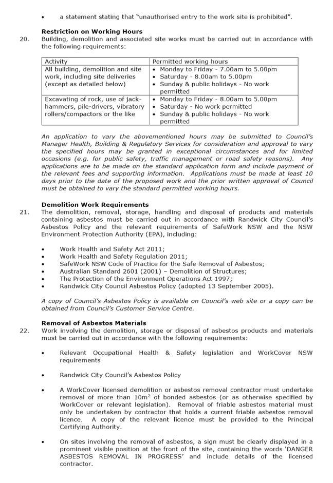
Restriction on Working Hours 22. Building, demolition and associated site works must be carried out in accordance with the following requirements:
An application to vary the abovementioned hours may be submitted to Council’s Manager Health, Building & Regulatory Services for consideration and approval to vary the specified hours may be granted in exceptional circumstances and for limited occasions (e.g. for public safety, traffic management or road safety reasons). Any applications are to be made on the standard application form and include payment of the relevant fees and supporting information. Applications must be made at least 10 days prior to the date of the proposed work and the prior written approval of Council must be obtained to vary the standard permitted working hours.
Demolition Work Requirements 23. The demolition, removal, storage, handling and disposal of products and materials containing asbestos must be carried out in accordance with Randwick City Council’s Asbestos Policy and the relevant requirements of SafeWork NSW and the NSW Environment Protection Authority (EPA), including:
· Work Health and Safety Act 2011; · Work Health and Safety Regulation 2011; · SafeWork NSW Code of Practice for the Safe Removal of Asbestos; · Australian Standard 2601 (2001) – Demolition of Structures; · The Protection of the Environment Operations Act 1997; · Randwick City Council Asbestos Policy (adopted 13 September 2005).
A copy of Council’s Asbestos Policy is available on Council’s web site or a copy can be obtained from Council’s Customer Service Centre.
Removal of Asbestos Materials 24. Work involving the demolition, storage or disposal of asbestos products and materials must be carried out in accordance with the following requirements:
· Relevant Occupational Health & Safety legislation and WorkCover NSW requirements · Randwick City Council’s Asbestos Policy · A WorkCover licensed demolition or asbestos removal contractor must undertake removal of more than 10m2 of bonded asbestos (or as otherwise specified by WorkCover or relevant legislation). Removal of friable asbestos material must only be undertaken by contractor that holds a current friable asbestos removal licence. A copy of the relevant licence must be provided to the Principal Certifying Authority. · On sites involving the removal of asbestos, a sign must be clearly displayed in a prominent visible position at the front of the site, containing the words ‘DANGER ASBESTOS REMOVAL IN PROGRESS’ and include details of the licensed contractor. · Asbestos waste must be stored, transported and disposed of in compliance with the Protection of the Environment Operations Act 1997 and the Protection of the Environment Operations (Waste) Regulation 2005. Details of the landfill site (which must be lawfully able to receive asbestos materials) must be provided to the Principal Certifying Authority. · A Clearance Certificate or Statement, prepared by a suitably qualified person (i.e. an occupational hygienist, licensed asbestos assessor or other competent person, must be provided to Council and the Principal certifying authority upon completion of the asbestos related works which confirms that the asbestos material have been removed appropriately and the relevant conditions of consent have been satisfied.
A copy of Council’s Asbestos Policy is available on Council’s web site or a copy can be obtained from Council’s Customer Service Centre.
Public Safety & Site Management 25. Public safety and convenience must be maintained at all times during demolition, excavation and construction works and the following requirements must be complied with:
a) Public access to the building site and materials must be restricted by existing boundary fencing or temporary site fencing having a minimum height of 1.5m, to Council’s satisfaction.
Temporary site fences are required to be constructed of cyclone wire fencing material and be structurally adequate, safe and constructed in a professional manner. The use of poor quality materials or steel reinforcement mesh as fencing is not permissible.
b) Building materials, sand, soil, waste materials, construction equipment or other articles must not be placed upon the footpath, roadway or nature strip at any time.
c) The road, footpath, vehicular crossing and nature strip must be maintained in a good, safe, clean condition and free from any excavations, obstructions, trip hazards, goods, materials, soils or debris at all times. Any damage caused to the road, footway, vehicular crossing, nature strip or any public place must be repaired immediately, to the satisfaction of Council.
d) All building and site activities (including storage or placement of materials or waste and concrete mixing/pouring/pumping activities) must not cause or be likely to cause ‘pollution’ of any waters, including any stormwater drainage systems, street gutters or roadways.
Note: It is an offence under the Protection of the Environment Operations Act 1997 to cause or be likely to cause ‘pollution of waters’, which may result in significant penalties and fines.
e) Sediment and erosion control measures, must be implemented throughout the site works in accordance with the manual for Managing Urban Stormwater – Soils and Construction, published by Landcom, to Council’s satisfaction. Details are to be provided in the Construction Site Management Plan and a copy is to be provided to the Principal Certifying Authority and Council.
f) Site fencing, building materials, bulk bins/waste containers and other articles must not be located upon the footpath, roadway or nature strip at any time without the prior written approval of the Council. Applications to place a waste container in a public place can be made to Council’s Health, Building and Regulatory Services department.
g) A Road / Asset Opening Permit must be obtained from Council prior to carrying out any works within or upon a road, footpath, nature strip or in any public place, in accordance with section 138 of the Roads Act 1993 and all of the conditions and requirements contained in the Road / Asset Opening Permit must be complied with. Please contact Council’s Road/Asset Openings officer on 9093 6691 for further details.
Support of Adjoining Land, Excavations & Retaining Walls 26. In accordance with section 80 A (11) of the Environmental Planning & Assessment Act 1979 and clause 98 E of the Environmental Planning & Assessment Regulation 2000, it is a prescribed condition that the adjoining land and buildings located upon the adjoining land must be adequately supported at all times.
27. All excavations and backfilling associated with the erection or demolition of a building must be executed safely in accordance with appropriate professional standards and excavations must be properly guarded and supported to prevent them from being dangerous to life, property or buildings.
Retaining walls, shoring or piling must be provided to support land which is excavated in association with the erection or demolition of a building, to prevent the movement of soil and to support the adjacent land and buildings, if the soil conditions require it. Adequate provisions are also to be made for drainage.
Details of proposed retaining walls, shoring, piling or other measures are to be submitted to and approved by the Principal Certifying Authority.
28. Prior to undertaking any demolition, excavation or building work in the following circumstances, a report must be obtained from a professional engineer which details the methods of support for the dwelling or associated structure on the adjoining land, to the satisfaction of the Principal Certifying Authority:
· when undertaking excavation or building work within the zone of influence of the footings of a dwelling or associated structure that is located on the adjoining land; · when undertaking demolition work to a wall of a dwelling that is built to a common or shared boundary (e.g. semi-detached or terrace dwelling); · when constructing a wall to a dwelling or associated structure that is located within 900mm of a dwelling located on the adjoining land; · as may be required by the Principal Certifying Authority.
The demolition, excavation and building work and the provision of support to the dwelling or associated structure on the adjoining land, must also be carried out in accordance with the abovementioned report, to the satisfaction of the Principal Certifying Authority.
Building Encroachments 29. There must be no encroachment of any structures or building work onto Council’s road reserve, footway, nature strip or public place.
Road/Asset Opening Permit 30. A Road / Asset Opening Permit must be obtained from Council prior to commencing any excavations or works within or upon a road, footpath, nature strip or in any public place, in accordance with section 138 of the Roads Act 1993 and all of the conditions and requirements contained in the Road / Asset Opening Permit must be complied with.
For further information, please contact Council’s Road / Asset Opening Officer on 9093 6691 or 1300 722 542.
REQUIREMENTS PRIOR TO THE ISSUE OF AN OCCUPATION CERTIFICATE The following conditions of consent must be complied with prior to the ‘Principal Certifying Authority’ issuing an ‘Occupation Certificate’.
Note: For the purpose of this consent, any reference to ‘occupation certificate’ shall also be taken to mean ‘interim occupation certificate’ unless otherwise stated.
These conditions have been applied to satisfy the relevant requirements of the Environmental Planning & Assessment Act 1979, Environmental Planning & Assessment Regulation 2000, Council’s development consent and to maintain reasonable levels of public health, safety and amenity.
Occupation Certificate Requirements 31. An Occupation Certificate must be obtained from the Principal Certifying Authority prior to any occupation of the building work encompassed in this development consent (including alterations and additions to existing buildings), in accordance with the relevant provisions of the Environmental Planning & Assessment Act 1979.
BASIX Requirements 32. In accordance with Clause 154B of the Environmental Planning & Assessment Regulation 2000, a Certifying Authority must not issue an Occupation Certificate for this development, unless it is satisfied that each of the required BASIX commitments have been fulfilled.
Relevant documentary evidence of compliance with the BASIX commitments is to be forwarded to the Council upon issuing an Occupation Certificate.
Swimming Pool Safety 33. Swimming pools are to be designed and installed in accordance with the relevant requirements of the Building Code of Australia and be provided with childproof fences and self-locking gates, in accordance with the Swimming Pools Act 1992 and the Swimming Pools Regulation 2008.
The swimming pool is to be surrounded by a fence having a minimum height of 1.2m, that separates the pool from any residential building (as defined in the Swimming Pools Act 1992) that is situated on the premises and from any place (whether public or private) adjoining the premises; and that is designed, constructed and installed in accordance with Australian Standard AS 1926.1 – 2012 (Swimming Pool Safety Part 1 - Safety Barriers for Swimming Pools).
Gates to pool area shall be a maximum width of 1 metre, and be self-closing and latching; the gate is required to open outwards from the pool area and prevent a small child opening the gate or door when the gate or door is closed.
Temporary pool safety fencing is to be provided pending the completion of all building work and the pool must not be filled until a fencing inspection has been carried out and approved by the principal certifying authority.
A ‘warning notice’ must be erected in a prominent position in the immediate vicinity of the swimming pool, in accordance with the provisions of the Swimming Pools Regulation 2008, detailing pool safety requirements, resuscitation techniques and the importance of the supervision of children at all times.
Note: This development consent does not approve the design and location of swimming pool fencing and other swimming pool safety barriers. Swimming pool fencing and other safety barriers are required to comply with the Swimming Pools Act 1992 and Swimming Pools Regulation 2008. Details of compliance are required to be incorporated into the plans and specifications for a Construction Certificate, to the satisfaction of the Certifying Authority.
Swimming Pool & Spa Pool Requirements 34. Swimming pools are to be designed, installed and operated in accordance with the following general requirements:
a) Backwash of the pool filter and other discharge of water is to be drained to the sewer in accordance with the requirements of the Sydney Water Corporation; and
b) All pool overflow water is to be drained away from the building and adjoining premises, so as not to result in a nuisance or damage to premises; and
c) Water recirculation and filtrations systems are required to comply with AS 1926.3 – 2010: Swimming Pool Safety – Water Recirculation and Filtration Systems; and
d) Pool plant and equipment is to be enclosed in a sound absorbing enclosure or installed within a building, to minimise noise emissions and possible nuisance to nearby residents.
Notification of Swimming Pools & Spa Pools 35. The owner of the premises must ‘register’ the swimming pool on the NSW Swimming Pool Register, in accordance with the Swimming Pools Amendment Act 2012.
The Swimming Pool Register is administered by the NSW Office of Local Government and registration on the Swimming Pool Register may be made on-line via their website www.swimmingpoolregister.nsw.gov.au.
Registration must be made before the issue of an Occupation Certificate for the pool.
Council’s Infrastructure & Vehicular Crossings 36. The applicant must meet the full cost for Council or a Council approved contractor to repair/replace any damaged sections of Council's footpath, kerb & gutter, nature strip etc which are due to building works being carried out at the above site. This includes the removal of cement slurry from Council's footpath and roadway.
37. All external civil work to be carried out on Council property (including the installation and repair of roads, footpaths, vehicular crossings, kerb and guttering and drainage works), must be carried out in accordance with Council's "Crossings and Entrances – Contributions Policy” and “Residents’ Requests for Special Verge Crossings Policy” and the following requirements:
a) Details of the proposed civil works to be carried out on Council land must be submitted to Council in a Civil Works Application Form. Council will respond, typically within 4 weeks, with a letter of approval outlining conditions for working on Council land, associated fees and workmanship bonds. Council will also provide details of the approved works including specifications and construction details.
b) Works on Council land, must not commence until the written letter of approval has been obtained from Council and heavy construction works within the property are complete. The work must be carried out in accordance with the conditions of development consent, Council’s conditions for working on Council land, design details and payment of the fees and bonds outlined in the letter of approval.
c) The civil works must be completed in accordance with the above, prior to the issuing of an occupation certificate for the development, or as otherwise approved by Council in writing.
38. That part of the naturestrip upon Council's footway which is damaged during the construction of the proposed works shall be excavated to a depth of 150mm, backfilled with topsoil equivalent with 'Organic Garden Mix' as supplied by Australian Native Landscapes, and re-turfed with Kikuyu turf or similar. Such works shall be completed at the applicant’s expense.
OPERATIONAL CONDITIONS The following operational conditions must be complied with at all times, throughout the use and operation of the development.
These conditions have been applied to satisfy the relevant requirements of the Environmental Planning & Assessment Act 1979, Environmental Planning & Assessment Regulation 2000, Council’s development consent and to maintain reasonable levels of public health and environmental amenity.
External Lighting 39. External lighting to the premises must be designed and located so as to minimise light-spill beyond the property boundary or cause a public nuisance.
Plant & Equipment – Noise Levels 40. The operation of all plant and equipment upon the premises shall not give rise to an ‘offensive noise’ as defined in the Protection of the Environment Operations Act 1997 and Regulations.
The operation of the plant and equipment shall not give rise to an LAeq, 15 min sound pressure level at any affected premises that exceeds the background LA90, 15 min noise level, measured in the absence of the noise source/s under consideration by more than 5dB(A) in accordance with relevant NSW Office of Environment & Heritage (EPA) Noise Control Guidelines.
Swimming/Spa Pools 41. The pool plant and equipment shall not be operated during the following hours if the noise emitted can be heard within a habitable room in any other residential premises, or, as otherwise specified in relevant Noise Control Regulations:
· before 8.00am or after 8.00pm on any Sunday or public holiday; or · before 7.00am or after 8.00pm on any other day.
Rainwater Tanks 42. The operation of plant and equipment associated with rainwater tanks are to be restricted to the following hours if the noise emitted can be heard within a habitable room in any other residential premises:
· before 8.00am or after 8.00pm on weekends or public holiday; or · before 7.00am or after 8.00pm on weekdays.
ADVISORY NOTES The following information is provided for your assistance to ensure compliance with the Environmental Planning & Assessment Act 1979, Environmental Planning & Assessment Regulation 2000, or other relevant legislation and Council’s policies. This information does not form part of the conditions of development consent pursuant to Section 80A of the Act.
A1 The requirements and provisions of the Environmental Planning & Assessment Act 1979 and Environmental Planning & Assessment Regulation 2000, must be fully complied with at all times.
Failure to comply with these requirements is an offence, which renders the responsible person liable to a maximum penalty of $1.1 million. Alternatively, Council may issue a penalty infringement notice (for up to $6,000) for each offence. Council may also issue notices and orders to demolish unauthorised or non-complying building work, or to comply with the requirements of Council’s development consent.
A2 This determination does not include an assessment of the proposed works under the Building Code of Australia (BCA) and other relevant Standards. All new building work (including alterations and additions) must comply with the BCA and relevant Standards and you are advised to liaise with your architect, engineer and building consultant prior to lodgement of your construction certificate.
A3 In accordance with the requirements of the Environmental Planning & Assessment Act 1979, building works, including associated demolition and excavation works (as applicable) must not be commenced until:
§ A Construction Certificate has been obtained from an Accredited Certifier or Council, § An Accredited Certifier or Council has been appointed as the Principal Certifying Authority for the development, § Council and the Principal Certifying Authority have been given at least 2 days notice (in writing) prior to commencing any works.
A4 Council’s Building Certification & Fire Safety team can issue your Construction Certificate and be your Principal Certifying Authority for the development, to undertake inspections and ensure compliance with the development consent, relevant building regulations and standards of construction. For further details contact Council on 9093 6944.
A5 A Local Approval application must be submitted to and be approved by Council prior to commencing any of the following activities on a footpath, road, nature strip or in any public place:
§ Install or erect any site fencing, hoardings or site structures § Operate a crane or hoist goods or materials over a footpath or road § Placement of a waste skip or any other container or article.
For further information please contact Council on 9093 6944.
A6 Specific details of the location of the building/s should be provided in the Construction Certificate to demonstrate that the proposed building work will not encroach onto the adjoining properties, Council’s road reserve or any public place.
A7 Underground assets (eg pipes, cables etc) may exist in the area that is subject to your application. In the interests of health and safety and in order to protect damage to third party assets please contact Dial before you dig at www.1100.com.au or telephone on 1100 before excavating or erecting structures (This is the law in NSW). If alterations are required to the configuration, size, form or design of the development upon contacting the Dial before You Dig service, an amendment to the development consent (or a new development application) may be necessary. Individuals owe asset owners a duty of care that must be observed when working in the vicinity of plant or assets. It is the individual’s responsibility to anticipate and request the nominal location of plant or assets on the relevant property via contacting the Dial before you dig service in advance of any construction or planning activities.
A8 The applicant is to advise Council in writing and/or photographs of any signs of existing damage to the Council roadway, footway, or verge prior to the commencement of any building/demolition works.
A9 Further information and details on Council's requirements for trees on development sites can be obtained from the recently adopted Tree Technical Manual, which can be downloaded from Council’s website at the following link, http://www.randwick.nsw.gov.au - Looking after our environment – Trees – Tree Management Technical Manual; which aims to achieve consistency of approach and compliance with appropriate standards and best practice guidelines.
A10 This consent does not authorise any trespass or encroachment upon any adjoining or supported land or building whether private or public. Where any underpinning, shoring, soil anchoring (temporary or permanent) or the like is proposed to be carried out upon any adjoining or supported land, the land owner or principal contractor must obtain:
§ the consent of the owners of such adjoining or supported land to trespass or encroach, or § an access order under the Access to Neighbouring Land Act 2000, or § an easement under section 88K of the Conveyancing Act 1919, or § an easement under section 40 of the Land & Environment Court Act 1979, as appropriate.
Section 177 of the Conveyancing Act 1919 creates a statutory duty of care in relation to support of land. Accordingly, a person has a duty of care not to do anything on or in relation to land being developed (the supporting land) that removes the support provided by the supporting land to any other adjoining land (the supported land).
|
|
1.⇩ |
Executive Report - 3 Seaview Street, Clovelly (DA 44 2017) Meeting 25 July 2017. |
|
|
2.⇩ |
DA Compliance Report - 3 Seaview Street, CLOVELLY |
|
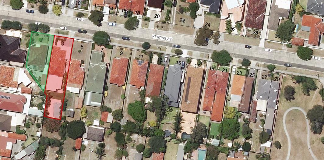
Development Application Report No. D76/17
Subject: 1 Keating Street, Maroubra (DA/445/2017)
Folder No: DA/445/2017
Author: Plandev Pty Ltd, Thomas Mithen
roposal: Alterations and additions to the existing outbuilding
Ward: Central Ward
Applicant: Mr S Zavlikaris
Owner: Mr S Zavlikaris & Mrs D Zavlikaris
Summary
Recommendation: Approval
|
|
|
|
Subject Site |
|
|
|
|
|
|
|
|
|
|
|
|
|
|
Submissions received
|
|
|
Ù North
|
|
|
Locality Plan |
Development Application Executive summary report
The application is being reported to the Planning Committee as the owner of an adjacent property is a Council employee.
Proposal
The application seeks approval for alterations and additions to an existing outbuilding in the rear yard to enable it to be used as a home gymnasium.
A site inspection undertaken on 9 October 2017 confirmed the building work had commenced (refer to Figure 1). The building works already undertaken and the remaining proposed works are as follows:
|
Existing building work already undertaken |
· extension to the height of the eastern wall by approximately 400 mm (plus the fascia and capping of 200 mm) on the common boundary with No. 3 Keating Street; · extension to the southern and northern walls by 400mm to 600 mm; · increase in the width of the structure by 610mm on the western side; · window openings at western and northern elevation; · new timber roof beams; · plumbing for new sink; · concrete pad footings; |
|
Proposed building work not yet undertaken |
· installation of the metal roof; · brick up window opening in the southern wall; · installation of glazing to the window openings; · internal fitout for a new sink; and · make good the slab to the west. |
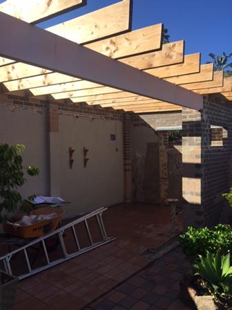
Figure 1 – Existing structure and new work already undertaken
The unauthorised construction works were brought to Council’s attention when an adjoining property owner lodged a complaint. As a result, Council’s Regulatory and Compliance Team have advised the owner that approval is required for the building works.
It should be noted that Council cannot grant retrospective approval for the works already completed. However, Council can approve the use of the structure, and the physical structure would need to be approved separately under a Building Certificate.
Site
The subject site is located in a low density residential area characterised by one and two storey dwelling houses. Many of the properties in the surrounding area contain outbuildings in the rear yard with nil setback to the boundary.
Submissions
The owners of adjoining and likely affected neighbouring properties were notified of the proposed development in accordance with the Randwick Comprehensive DCP 2013. One submission in objection was received as a result of the notification process from the adjoining property owner at No. 3 Keating Street raising concerns with the unauthorized work and the exceedance of Council’s external wall height control of 2.4 metres on the common boundary.
Key Issues
The key issue relates to the unauthorized works associated with the alterations and additions to the existing outbuilding on the site. As retrospective approval cannot be given for any building works completed, Council has the power to grant approval for the use of the outbuilding but not for any building works already completed prior to the consent being granted.
In terms of whether the use of the outbuilding is appropriate for the site, an assessment is undertaken against the controls in Section 7.4 Outbuildings of Randwick Development Control Plan 2013 (RDCP 2013).
The proposal complies with the maximum single storey and 3.6 metre height control for outbuildings in RDCP 2013. However, the eastern wall on the boundary adjoining No. 3 Keating Street will be 2.75 metres, and therefore exceeds the 2.4 metre maximum wall height control by 350 mm.
The owners of the adjoining property at No. 3 Keating Street have raised concerns the increased height of the wall on the boundary does not comply with the Council controls. The location of the outbuilding in relation to the adjoining property is illustrated in Figures 2 and 3.
Based on a merit assessment of the proposal, the non-compliance with the external wall height control is acceptable given:
· the western elevation of the dwelling at No. 3 Keating adjacent to the outbuilding does not contain any window openings;
· it is not visible from the principal living areas on the eastern side of the dwelling at No. 3 Keating Street;
· it does not extend beyond the rear alignment of No. 3 Keating Street;
· it complies with the maximum height control of single storey and 3.6 metres;
· it would not result in any unreasonable overshadowing impacts to the adjoining properties; and
· it is located in the same position as the existing structure except for the extended footprint to the west.
The proposal is appropriate for the site and can be supported.
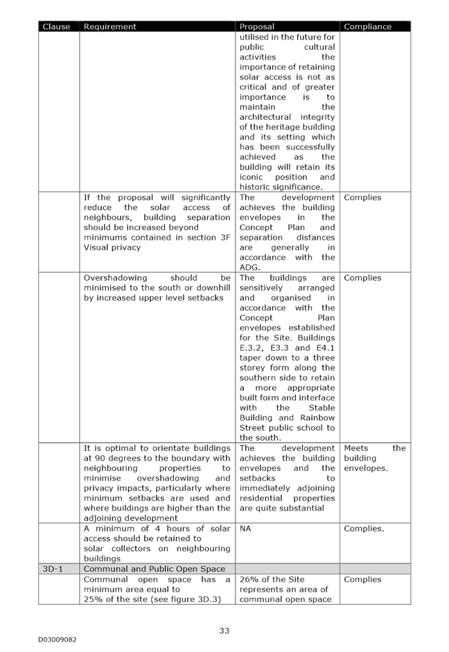
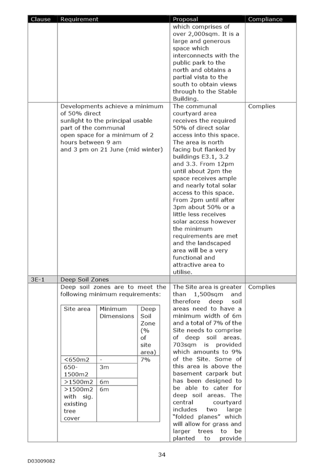
![]()
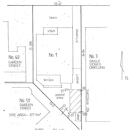
Figure 2 – Location of the outbuilding in relation to the adjoining properties
![]()
![]()
![]()
![]()
![]()
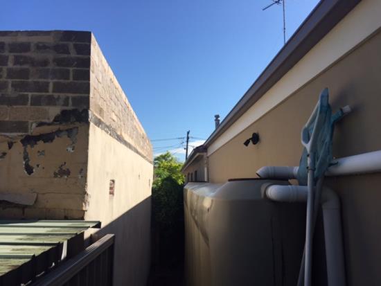
Figure 3 – Unauthorised works already undertaken to the boundary wall
Relationship to City Plan
The relationship with the City Plan is as follows:
Outcome 4: Excellence in urban design and development.
Direction 4a: Improved design and sustainability across all development.
Financial impact statement
There is no direct financial impact for this matter.
Conclusion
The development application (DA) seeks approval for alterations and additions to the existing outbuilding at the rear of the site.
Whilst Council cannot grant retrospective approval for the works already completed, it can approve the use of the structure. Following an assessment against the relevant outbuilding controls in RDCP 2013, the proposed structure is considered to be appropriate for the site, particulalry given it would not result in any unreasonable amenity impacts to the adjoining properties.
The use of the existing structure as a home gym and the proposed works including a new metal roof, installation of glazing to the window openings and internal fitout are supported.
|
That Council, as the consent authority, grants development consent under Sections 80 and 80A of the Environmental Planning and Assessment Act 1979, as amended, to Development Application No. 445/2017 for use of the existing structure as a home gym and the proposed works including a new roof, installation of glazing to the window openings and internal fitout, at No. 1 Keating Street, Maroubra, subject to the following non standard condition and the standard conditions contained in the development application compliance report attached to this report:
Non Standard Condition 2. This approval does not include any building works that have been completed prior to the issue of the subject development consent including the new walls and roof timbers and only applies to the work not undertaken including the proposed metal roof, window glazing and internal fitout.
|
|
1.⇨ |
DA Compliance Report - DA/445/2017 - 1 Keating Street, MAROUBRA |
Included under separate cover |
Planning Committee 14 November 2017
Development Application Report No. D77/17
Subject: 1 Keating Street, Maroubra (DA/549/2017)
Folder No: DA/549/2017
Author: Plandev Pty Ltd, Thomas Mithen
Proposal: New front double hardstand car space and front boundary fence, new storage on the eastern side of the dwelling
Ward: Central Ward
Applicant: Mr S Zavlikaris
Owner: Mr S Zavlikaris & Mrs D Zavlikaris
Summary
Recommendation: Approval
|
|
|
|
Subject Site |
|
|
|
|
|
|
|
|
|
|
|
|
|
|
Submissions received
|
|
|
Ù North
|
|
|
Locality Plan |
Development Application Executive summary report
The application is being reported to the Planning Committee as the owner of an adjacent property is a Council employee.
Proposal
A site inspection undertaken on 9 October 2017 confirmed the fence had already been constructed, except for the sliding gate and metal infill between the brick piers. The preparatory ground works at the front of the dwelling required for the proposed hardstand car spaces had also commenced (refer to Figure 1).
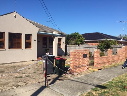
Figure 1 – Location of proposed hardstand car spaces and existing fence
The unauthorized construction works was brought to Council’s attention when an adjoining property owner lodged a complaint. As a result, Council’s Regulatory and Compliance Team have advised the owner that approval is required for the building works.
It should be noted that Council cannot grant retrospective approval for the works already completed. However, Council can approve the use of the fence, and the physical structure would need to be approved separately under a Building Certificate.
Site
The subject site is located in a low density residential area characterised by one and two storey dwelling houses. The streetscape consists of garages and parking in the front setback of dwellings.
Submissions
The owners of adjoining and likely affected neighbouring properties were notified of the proposed development in accordance with the Randwick Comprehensive DCP 2013. No written submissions were received as a result of the notification process. However, at the site inspection undertaken on 9 October 2017, the neighbours at No. 3 Keating Street expressed concern with the unauthorized works and the provision of a double hardstand car spaces and loss of permeable area and streetscape impacts.
Key Issues
· Streetscape
Section 6.7 of RDCP 213 permits hardstand car spaces forward of the building alignment. Due to the site constraints there is no alternative but to provide a parking space in the front setback as the eastern driveway between the property boundary and the dwelling is too narrow at 2.1 metres wide. A hardstand carspace is required to include permeable materials, such as porous paving or gravel over deep soil or between concrete wheel strips. The proposed hardstand area would comprise a stenciled concrete slab and therefore does not satisfy the permeable materials requirement.
The adjoining property to the east at No. 3 Keating Street contains a hardstand driveway and double garage forward of the building alignment. The wider streetscape also includes garages and hardstand car spaces in the front setback of dwellings. On that basis the proposed hardstand car spaces are appropriate for the site.
However, to reduce the visual impact associated with the hardstand area, the existing layback should not be increased in width and the driveway slab should splay to a maximum width of 4 metres at the Council footpath line. Conditions to this effect are included in the recommended development consent.
· Landscape
Section 2.4 of RDCP 2013 requires a minimum of 25 per cent permeable landscape surface. The proposal would reduce the permeable surface to 18 per cent of the site.
The proposal includes a pathway between the front boundary and the dwelling and around the western side of the dwelling. In order to maximise the permeable surface area and improve the visual amenity of the site, the pathway should consist of stepping stones and loose gravel. The pathway that extends west from the front of the dwelling and around the western side of the dwelling should be deleted and replaced with turf. Conditions to this effect are included in the recommended development consent.
· Front Fence
Section 7.2 of RDCP 2013 requires front fence at a maximum height of 1.2 metres. The proposed front fence is a maximum of 1.31 metres in height at its western end and would result in a minor non-compliance by 110mm. It is noted that the adjoining properties contain a front fence that also exceed the maximum 1.2 metre height control. The streetscape is characterized by a variety of fence types, and the proposed fence would not be uncharacteristic element within the street.
Relationship to City Plan
The relationship with the City Plan is as follows:
Outcome 4: Excellence in urban design and development.
Direction 4a: Improved design and sustainability across all development.
Financial impact statement
There is no direct financial impact for this matter.
Conclusion
The development application (DA) seeks approval for a new front double hardstand car space and front boundary fence and new storage shed on the eastern side of the dwelling.
Following an assessment against the relevant controls in RDCP 2013, the these new elemants are considered to be appropriate for the site.
Council cannot grant retrospective approval for the front fence, which has already been completed, except for the gate and metal infill between the piers. This component would require a separate approval under a Building Certificate.
The proposed storage shed on the eastern side of the dwelling would not result in any unreasonable amenity impacts to the adjoining property at No. 3 Keating Street.
The proposed double hardstand car spaces would be generally consistent with the streetscape characater, which includes hardstand areas and garages forward of the building alignment.
|
That Council, as the consent authority, grants development consent under Sections 80 and 80A of the Environmental Planning and Assessment Act 1979, as amended, to Development Application No. 445/2017 for a new front double hardstand car space and front boundary fence and new storage on the eastern side of the dwelling, at No. 1 Keating Street, Maroubra, subject to the following non standard condition and the standard conditions contained in the development application compliance report attached to this report:
Non Standard Conditions Amendment of Plans & Documentation 3. The approved plans and documents must be amended in accordance with the following requirements:
a. The proposed pathway between the front street boundary and the dwelling shall consist of stepping stones surrounded by a permeable material such as pebbles or grass and the pathway extension which extends around the western side of the dwelling shall be deleted and replaced with soft landscape such as grass.
Council’s Infrastructure, Vehicular Crossings, street verge 13. The applicant must meet the full cost for a Council approved contractor to:
a. Splay/extend the existing Council concrete driveway slab from the existing layback out to a width of 4.00m at the Council footpath line. The works are to be done to Council’s specifications and requirements.
|
|
1.⇨ |
DA Compliance Report - 1 Keating Street, MAROUBRA |
Included under separate cover |
Planning Committee 14 November 2017
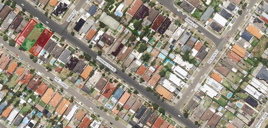
Development Application Report No. D78/17
Subject: 2-18 Tunstall Avenue, Kensington (DA/334/2017)
Folder No: DA/334/2017
Author: Chahrazad Rahe, Senior Assessment Planner
Proposal: Demolition of existing workshop, administration and amenities structures, construction of new workshop/maintenance building comprising of plant room, vehicle storage, store rooms, amenities, office, mezzanine level and paved apron area utilising existing access at the Australian Golf Club
Ward: West Ward
Applicant: Platform Projects
Owner: The Australian Golf Club Ltd
Summary
Recommendation: Approval
|
|
|
|
Subject Site |
|
|
|
|
|
|
|
|
|
|
|
|
|
|
Submissions received
|
|
|
Ù North
|
|
|
Locality Plan |
Development Application Executive summary report
The application is referred to the Planning Committee for determination as the proposed works are valued over $2 million.
1. Proposal
The applicant is seeking approval for demolition of the existing workshop, administration and amenities structures on the site to allow for the construction of new workshop and maintenance building comprising of plant room, vehicle storage, store rooms, amenities, office, mezzanine level. The proposal also includes a paved apron area utilising existing access at the Australian Golf Club.
The new workshop/maintenance shed (53.16m long x 21.3m) comprises:
· Plant room;
· Vehicle storage area (36m x 10.2m) with no wall openings along northern boundary;
· Store rooms for oil & batteries;
· General storeroom;
· Amenities;
· Office;
· Mezzanine level along western elevation (no wall openings); and
· Amenities (external access from southern elevation).
The new staff facilities building contains:
· Two offices and reception area;
· Staff room;
· Conference/training room;
· Uniform store;
· Male and female change rooms;
· Wet room/laundry; and
· Open area – BBQ at the northern end of the building.
The maintenance compound is currently operated between 5:30am and 3:00pm each day for activities ancillary and incidental to the maintenance of the gold course. There are no change to hours of use as a result of this proposal. The mechanical workshop activities do not occur between 5:30am and 7:00am. The SEE also states that on Saturday it is not anticipated that the use of the compound would extend past 9:00am.
2. Subject site & surrounding area
The subject site is described as Lot 1 DP 2400490 and is known as 2-16 Tunstall Avenue, Kensington. The subject site is located on the western side of Tunstall Avenue between Gardeners Road and Addison Road in Kensington. The site is bounded to the west and southwest by Southern Cross Drive which also forms the western boundary of the Randwick LGA, Gardeners Road to the south and by residential development to the north and east.
The subject site is currently occupied by the Australian Golf Course and has an overall area of approximately 62.31ha. The site is highly modified, comprising primarily mown lawn that forms the tees, fairways and greens of the gold course. The service area which is the subject of this application is located at the northern end of the site, with the vehicular and pedestrian access to this part of the site being off Sherwood Street. Below is an aerial view of the subject site and surrounding area.
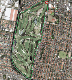
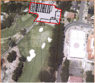
Figure 1: Location of proposed development shown in red and the entire site is shown in green
3. Submissions
The owners of adjoining and likely affected neighbouring properties were notified of the proposed development in accordance with the Randwick Comprehensive DCP 2013. No submissions were received as a result of the notification process.
4. Key Issues
4.1 Relevant Environment Planning Instruments:
State Environmental Planning Policy No. 55 Remediation of Land
The location of the proposal is at the northern end of the course within an existing maintenance compound. There is no evidence to suggest the site is contaminated or used for purposes other than as an open golf course since at least 1943.
No further investigation is necessary.
Randwick LEP 2012
Zone RE2 – Private Recreation
The site is zoned Private Recreation RE2 under Randwick Local Environmental Plan 2012 and the proposal is permissible with Council’s consent. The objective of RE2 - Private Recreation Zone is to enable private recreation facilities to be provided on privately owned land.
The existing golf course and clubhouse facilities are a longstanding land use on the subject site. The proposal is ancillary and incidental to the operation of the outdoor recreational facility and is required for the operation of the outdoor recreation facility.
The proposal will be improve the facilities on site for the Australian Golf Course by providing two building structures that will assist in the provision of maintains and repairs solely for the golf club use and purposes.
As such the proposed works are considered to be consistent with the objective and use of the site as a private recreation facility.
Clause 5.10 - Heritage Conservation
The subject site is not listed as a heritage item and not located in a heritage conservation area. However, there are a number of heritage items and conservations in the vicinity of the golf course site, namely, West Kensington Heritage Conservation area and the Sacred Heart Heritage Conservation Area. There will be no impacts on the listed heritage items as a result of the development which is physically separated from the curtilage of the golf course, with proposed works wholly contained to the northern end of the golf course and located a fair distance away from the heritage items.
The sacred Heart HCA being closest to the subject site contains a large area of church owned land bounded by Addison Street to the north and Tunstall Avenue to the west and extending east of Kensington Road and south of Roma Avenue. The proposal has no significant adverse impact on this area. The demolition of the existing structures and their replacements with two new buildings will in fact be improving the visual appearance of the maintenance compound.
Randwick Comprehensive DCP 2013
The DCP provisions are structured into two components, Objectives and Controls. The Objectives provide the framework for assessment under each requirement and outline key outcomes that a development is expected to achieve. The controls contain both numerical standards and qualitative provisions. Any proposed variations from the controls may be considered only where the applicant successfully demonstrates that an alternative solution could result in a more desirable planning and urban design outcome.
Part B1 – General Provisions
B1 Design
The two new buildings are located within the existing maintenance area at the northern end of the golf course. The buildings adjoin residential properties to the north and east ends of the boundaries. The staff building to the east end of the boundary is excavated and has been recessed within the contours of the land. The wall of this building is setback approximately 1.8m from the eastern side of the boundary and as viewed from the neighbouring resident at no. 24 Balfour Road the wall height of the building will vary from approximately 2.2m to a maximum height of 2.7m from the natural ground level. This will provide a buffer between the properties and will not result in unacceptable visual, privacy or overshadowing impacts to this neighbouring property.
The work shop and storage building to the northern end of the boundary is generally fixed on the boundary with numbers 71 – 65 Milroy Avenue. The majority of this wall height is below the neighbouring properties masonry garage wall with the exception of the wall height western end of the building extending 1.475m above the existing masonry wall height along the boundaries of no.’s 67 and 65 Milroy Avenue.
The wall height for this building is considered to be acceptable and will not result in unacceptable visual impacts to these neighbours that abut onto the northern side of the boundary. Also, there will be no additional overshadowing impacts to these properties.
Overall, the development will improve the visual amenity of the maintenance compound and staff facilities as viewed from neighbouring properties and streetscape. The buildings have been designed with an appropriate scale to the street. The proposed materials are non-reflective, steel or dark grey in colour which will blend into the existing vegetation on the golf course. The buildings are provided with good amenities and will improve the efficiency of the maintenance operation for the golf course.
Part F1 Development in Recreation Zones
The proposed development will continue to supports and complements the existing recreation areas and will not be altering the ongoing use of the land as a golf course. The proposed upgraded buildings are located within an area which already is dedicated for maintenance and service of the golf course. The buildings within this area are rundown. The proposed development will offer an improvement on the visual amenity to residential properties within the immediate neighbourhood.
The ongoing maintenance of the course is a daily operational requirement of the business and the new maintenance compound and staff facilities buildings will assist in the essential maintenance operations of the golf course.
Overall, the development will enhance the existing use of the land and will not hinder its continued use as a golf course.
The likely impacts of that development
The development will improve the service provided for the golf course and will support the existing open space use of the site. The building has been located and designed so that it is not significantly visible from surrounding properties or the street and will not have a negative impact on the visual qualities of the surrounding golf course. The building will not result in excessive density on the site and will not result in additional traffic impacts as the numbers of staff will not be increased on the site as the aim of the proposal is to improve on the existing facilities rather than to increase the intensity of use on the site. As discussed above in Part B1, the development is considered to have negligible impacts on the site and its surrounding residential locality.
The public interest
The improvements to the existing golf course will result in benefits in terms of amenity to staff and members by providing a maintenance and office buildings to support the operations of the golf course. The proposal will over an improvement to residential amenity in the immediate neighbourhood and the workshops have been orientated away from the residential properties to minimise noise.
There have been no submissions from the public in response to the notification and advertising periods. As such, the development is considered to be in the public interest.
The development is satisfactory with regard to s79(C) of the EP & A Act.
5. Referrals
5.1 Development Engineering
This report is based on the following plans and documentation:
· Architectural Plans by Beccera Architects, dated 27th March 2017;
· Statement of Environmental Effects by Andrew Martin Planning dated 1st June 2017;
· Flood Study by Meinhardt dated October 2017;
· Landscape Schematic Plan & Planting Projections by GCH, dated 05/04/17.
Flooding Comments
The site lies within the catchment of the Council commissioned and adopted West Kensington/Green Square Flood Study which predicts some flooding in the vicinity of the site. As the proposed development had the potential to significantly alter flood levels, the Drainage Engineer advised that the issuing of a flood report was not appropriate in this instance and the applicant needed to provide additional information demonstrating that the development was not affected by flooding post development and flood levels would not increase on any adjacent property.
![]() A site specific Flood study by Meinardt Pty Ltd has now been
submitted and the following comments are made in relation to flooding
identified with this study.
A site specific Flood study by Meinardt Pty Ltd has now been
submitted and the following comments are made in relation to flooding
identified with this study.
Existing Situation
During large storm events ponding occurs at the low point in Tunstall Avenue eventually overtopping the kerb and gutter to the west and flowing into the Australian Golf Club, The topography of the grass verge where the overtopping occurs results in overland flow being split in two directions. The first being directed to the west and onto the green area at the end of Hole 5 and also along the southern edge of the maintenance building and eventually heading south west through the golf course.
Proposed Development
The proposed development will comprise of two buildings
· A single storey office building with conference room, meeting rooms and staff amenities (Building 1).
· A 2 storey vehicle storage building with storerooms and office and toliets to the north west (Building 2)
The flood study notes the following flooding impacts of the proposed development
Building 2 has a minimal impact on the existing flow path
Building 1’s location increases the width of the flow to the west but restricts any flow from travelling to the north towards Sherwood Street. This flow will need to be catered fo to avoid a trapped low point being created in the depressed grassed area without any stormwater infrastructure to drain it.
As a solution the study proposes the implementation of both a concrete lined channel and a grass lined channel to formally convey any overland flows around the proposed site mitigating any potential flooding risks to the site and neighbouring properties. The channels have also been designed to meet the flood planning levels of Part B8 of the DCP by ensuring the finished building levels are twice the depth of flow above the base of the channel.
A condition has been provided in this report requiring plans submitted for the Construction Certificate formally adopt these measures as specified in Appendix E of the flood study, Along with certification prior to the issuing of a final occupation certificate.
Drainage Comments
Section 3.4 Part B8 of Council’s DCP prohibits new building over Council pipe infrastructure however it is noted the existing maintenance building is built over existing Council stormwater pipelines including a 375mm diameter pipe draining from Tunstell Avenue and a 750mm diameter pipe draining from Sherwood Street.
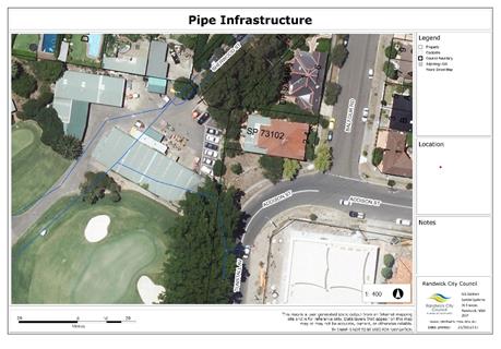
The proposed development will significantly reduce the area of building over the 375mm diameter pipe, but proposed building 2 (vehicle storage) will encroach over a small section of the 750mm pipe as well as significantly over another 1050mm diameter Council pipe located nearby. The Council pipelines have not been noted on the architectural plans or the Statement of Environmental Effects.
Development over pipe infrastructure cannot be supported as it is conflict with the DCP and may restrict access to the pipelines for future maintenance or replacement.
For the application to be supported in its current form the pipes will need to be relocated. Suitable conditions have bene included in this report.
Landscape Comments
The inspection of 26 September revealed a variety of established canopy trees adjacent to the existing storage sheds, which were observed to contribute to site and area amenity, but which may be impacted by the works, as discussed below.
Along the eastern site boundary, fronting Tunstall Avenue, adjacent the southeast corner of the existing brick & metal storage shed, there is a large and mature Ficus microcarpa var. ‘Hillii’ (Hills Weeping Fig), which is part of a significant row planting that extends to further to the west, and whose northern aspect partially overhangs this shed.
The plans show that the new footprint will actually be reduced in size, increasing the offset from this tree by an extra 3m, and while the existing footing/slab would have restricted/re-directed root growth, given the large size and potential root spread of this tree into the area of the proposed works, protection measures still need to be imposed, and have been included as conditions in this report, along with those that permit minimal clearance pruning where needed.
In order to address flooding issues that were identified at this site, further details have been received (Local Flood Study – Appendix E), showing that a 1.60m wide, 150mm deep concrete lined channel will be provided along the length of the eastern side of the new building; however, as this new work will not extend past the southeast corner of the new footprint, no additional impacts are expected, with the existing Tree Protection Conditions sufficient to deal with any impacts that may arise from this component.
To its west, near the southwest corner of this same shed, on the southern side of the existing access road, there is a stand of 6-8m tall, closely planted native trees, comprising a Leptospermum patersonii (Lemon Scented Tea Tree), a Grevillea robusta (Silky Oak) and a Melaleuca armillaris (Bracelet Honey Myrtle) which despite not significant in anyway, are covered by the DCP.
The existing shed is located well away, about 5m to their north, with the new footprint (retaining wall) to encroach much closer, resulting in an offset of only 1-1.5m being provided from the two most northern trees in this group, as is shown on dwg A102, so permission has been granted for the removal of these two trees only.
While it was originally proposed to retain the remaining trees in this group, this will now no longer be possible as a 4.90m wide, 400mm deep, grass lined channel needs to be constructed along the length of the southern side of the building, between its southeast corner and the internal access road, to deal with flood levels that have been identified as an issue in this area, with the changes/re-contouring of existing ground levels here to necessitate their removal, with conditions allowing this, as in the context of this site and other trees that are remaining in the immediate area, they are not significant in anyway, with the relevant consent for this provided.
To their northwest, on the western side of the existing access road, and to the southeast of the existing ‘covered wash bay/fuel/chemical area’, growing in a raised garden bed bordered by concrete kerb, there is a mature, 12m tall Phoenix canariensis (Canary Island Date Palm) which is covered by the DCP, and whose crown is recognized as a feature in the immediate area.
The curved entry/retaining wall shown to its south and east (dwg A102) will be provided in virtually the same area as the existing road surface, and as this palm can remain in the existing contained garden bed, it should remain unaffected, with only minimal protection conditions required.
The variety of shrubs/small trees on the sloped embankment to the northwest of the existing sheds, around the northwest corner of the scope of works will be in direct conflict with the new footprint, and while they may assist with privacy and amenity for the adjoining private properties to the north (most notably 65 Milroy Avenue), none are significant, so conditions allow their removal where necessary, including the Cinnamomum camphora (Camphor Laurel) along the western edge of the existing shed in this area, with reasonable levels of environmental amenity to be maintained as the Landscape Plan shows the mass-planting of native canopy trees back in this same area.
The Site Plan (dwg A100) showing that the stand of three established Date Palms behind the 6th Tee/free-standing shed, adjacent the rear boundaries of 63 & 65 Milroy Avenue, should remain unaffected given their distance from the works, with only minimal conditions required.
The submitted Landscape Plans show that new mass planting will be provided along the entire length of the southern side of the new shed, so as to assist with its integration into the natural settings, with conditions requiring that this formally provided on site as part of any approval.
Relationship to City Plan
The relationship with the City Plan is as follows:
Outcome 4: Excellence in urban design and development.
Direction 4a: Improved design and sustainability across all development.
Financial impact statement
There is no direct financial impact for this matter.
Conclusion
The proposal complies with the relevant assessment criteria and the objectives for the Part F1 - Development in Recreation Zones and will not result in any unreasonable adverse impacts upon either the amenity of the adjoining premises or the character of the locality. It is considered the development is minor and ancillary to the existing open space use of the site and the scale and design of the proposal is considered to be suitable for the location and is compatible with the desired future character of the locality.
The proposed development satisfies the matters for consideration under Section 79C of the Environmental Planning and Assessment Act 1979, as amended and the relevant legislation, State policies and local planning controls. The application is accordingly recommended for approval subject to proposed conditions of consent.
|
That Council, as the consent authority, grants development consent under Sections 80 and 80A of the Environmental Planning and Assessment Act 1979, as amended, to Development Application No. DA/334/2017 for demolition of existing workshop, administration and amenities structures, construction of new workshop/maintenance building comprising of plant room, vehicle storage, store rooms, amenities, office, mezzanine level and paved apron area utilising existing access at the Australian Golf Club, at No. 2-18 Tunstall Avenue, Kensington, subject to the standard conditions contained in this report:
Approved Plans & Supporting Documentation 1. The development must be implemented substantially in accordance with the plans and supporting documentation listed below and endorsed with Council’s approved stamp, except where amended by Council in red and/or by other conditions of this consent:
REQUIREMENTS BEFORE A CONSTRUCTION CERTIFICATE CAN BE ISSUED The following conditions of consent must be complied with before a ‘Construction Certificate’ is issued by either an Accredited Certifier or Randwick City Council. All necessary information to demonstrate compliance with the following conditions of consent must be included in the documentation for the construction certificate.
These conditions have been applied to satisfy the relevant requirements of the Environmental Planning & Assessment Act 1979, Environmental Planning & Assessment Regulation 2000, Council’s development consent conditions and to achieve reasonable levels of environmental amenity.
Section 94A Development Contributions 2. In accordance with Council’s Section 94A Development Contributions Plan effective from 21 April 2015, based on the development cost of $3,135,000 the following applicable monetary levy must be paid to Council: $31,350.
The levy must be paid in cash, bank cheque or by credit card prior to a construction certificate being issued for the proposed development. The development is subject to an index to reflect quarterly variations in the Consumer Price Index (CPI) from the date of Council’s determination to the date of payment. Please contact Council on telephone 9093 6999 or 1300 722 542 for the indexed contribution amount prior to payment. To calculate the indexed levy, the following formula must be used: IDC = ODC x CP2/CP1
Where: IDC = the indexed development cost ODC = the original development cost determined by the Council CP2 = the Consumer Price Index, All Groups, Sydney, as published by the ABS in respect of the quarter ending immediately prior to the date of payment CP1 = the Consumer Price Index, All Groups, Sydney as published by the ABS in respect of the quarter ending immediately prior to the date of imposition of the condition requiring payment of the levy.
Council’s Section 94A Development Contribution Plans may be inspected at the Customer Service Centre, Administrative Centre, 30 Frances Street, Randwick or at www.randwick.nsw.gov.au.
Compliance Fee 3. A development compliance and enforcement fee of $3,135 shall be paid to Council in accordance with Council’s adopted Fees & Charges Pricing Policy, prior to the issue of a Construction Certificate for development.
Long Service Levy 4. Any required Long Service Levy payment, under the Building and Construction Industry Long Service Payments Act 1986, is to be forwarded to the Long Service Levy Corporation or the Council, prior to the issuing of a Construction Certificate, in accordance with Section 109F of the Environmental Planning & Assessment Act 1979.
At the time of this development consent, Long Service Levy payment is applicable on building work having a value of $25,000 or more, at the rate of 0.35% of the cost of the works.
Security Deposit 5. The following damage / civil works security deposit requirement must be complied with as security for making good any damage caused to the roadway, footway, verge or any public place; and as security for completing any public work; and for remedying any defect on such public works, in accordance with section 80A(6) of the Environmental Planning and Assessment Act 1979:
· $8,000.00 - Damage / Civil Works Security Deposit
The damage/civil works security deposit may be provided by way of a cash, cheque or credit card payment and is refundable upon a satisfactory inspection by Council upon the completion of the civil works which confirms that there has been no damage to Council's infrastructure.
The owner/builder is also requested to advise Council in writing and/or photographs of any signs of existing damage to the Council roadway, footway, or verge prior to the commencement of any building/demolition works.
To obtain a refund of relevant deposits, a Security Deposit Refund Form is to be forwarded to Council’s Director of City Services upon issuing of an occupation certificate or completion of the civil works.
Flood Planning 6. Plans submitted for the construction certificate must demonstrate the formal adoption of the flood mitigation measures as recommended in the Local Flood Study by Meinhardt Pty Ltd dated October 2017 Issue c and stamped by Council 17 October 2017 including but not limited to the construction of the concrete and grass swales around the eastern and southern edge of southern building. The following requirements must also be met;
· The Floor level of the building/s are to be set at twice at the depth of the flow above the base of the channel (being the flood planning level) or suitably protected up to this level. · The building/s are to be constructed of flood compatible material for any part of the building below the flood planning level.
Stormwater Drainage 7. As the development is proposed to be constructed over existing Council pipe infrastructure, which is not permitted under Section 3.4 Part B8 of Council’s DCP, the applicant is to submit to Council for approval and have approved, “for construction” plans to relocate the affected Council stormwater lines. All costs associated with the reconstruction of the Council lines shall be met by the developer/applicant. The plans shall be prepared by a certified practicing Hydraulic Engineer and demonstrate compliance with the following requirements;
a) The drainage Plans must include a detailed specification which must be prepared in consultation with Council’s Development Engineering Coordinator.
b) All affected Council lines must be identified and accurately located relative to the proposed development.
c) Relocated pipes must be positioned outside of the footprint of the proposed buildings with the centreline of any relocated pipe setback a minimum of 1.5m from any external wall or structure.
d) Certification of the proposed design from a certified practicing Hydraulic engineer is to be provided.
e) Existing pipeline/s must remain fully operational until such time as an alternate stormwater drainage system has been constructed to Council’s satisfaction.
f) The diversion/upgrade of the Council Line/s will be required to be completed prior to commencement of building works within the site unless otherwise approved in writing by the Development Engineering Coordinator.
8. Detailed drainage plans for the internal site drainage system with levels reduced to Australian Height Datum (AHD), shall be prepared by a suitably qualified Hydraulic Engineer and be submitted to and approved by the certifying authority. A copy of the plans shall be forwarded to Council, if Council is not the certifying authority.
The drainage plans must demonstrate compliance with the Building Code of Australia, Australian Standard AS3500.3:2003 (Plumbing and Drainage - Stormwater Drainage) and the relevant conditions of this development approval.
9. The site stormwater drainage system is to be provided in accordance with the following requirements;
a) The stormwater drainage system must be provided in accordance with the relevant requirements of Building Code of Australia and the conditions of this consent, to the satisfaction of the Certifying Authority and details are to be included in the construction certificate.
b) The site stormwater from the redeveloped portion of the site must be discharged (by gravity) either:
i. Directly to the existing pipe system within the site. ii. To a suitably designed infiltration system (subject to confirmation in a full geotechnical investigation that the ground conditions are suitable for the infiltration system),
NOTES: · Infiltration will not be appropriate if the site is subject to rock and/or a water table within 2 metres of the base of the proposed infiltration area, or the ground conditions comprise low permeability soils such as clay.
c) Should stormwater be discharged to Council’s street drainage system, an on-site stormwater detention system must be provided to ensure that the maximum discharge from the redeveloped portion of the site does not exceed that which would occur during a 20% AEP (1 in 5 year storm of one hour duration for existing site conditions. All other stormwater run-off from the site for all storms up to the 5% AEP (1 in 20 year) storm is to be retained on the site for gradual release to the street drainage system, to the satisfaction of the certifying authority.
An overland escape route or overflow system (to Council’s street drainage system) must be provided for storms having an annual exceedance probability (AEP) of 1% (1 in 100 year storm), or, alternatively the stormwater detention system is to be provided to accommodate the 1% AEP (1 in 100 year) storm.
d) Should stormwater be discharged to an infiltration system the following requirements must be met;
i. Infiltration systems/Absorption Trenches must be designed and constructed generally in accordance with Randwick City Council's Private Stormwater Code.
ii. The infiltration area shall be sized for all storm events up to the 5% AEP (1 in 20 year) storm event with provision for a formal overland flow path to Council’s Street drainage system.
Should no formal overland escape route be provided for storms greater than the 5% AEP (1 in 20yr) design storm, the infiltration system shall be sized for the 1% AEP (1 in 100yr) storm event.
iii. Infiltration areas must be a minimum of 3.0 metres from any structure (Note: this setback requirement may not be necessary if a structural engineer or other suitably qualified person certifies that the infiltration area will not adversely affect the structure)
iv. Infiltration areas must be a minimum of 2.1 metres from any site boundary unless the boundary is common to Council land (eg. a road, laneway or reserve).
e) Determination of the required cumulative storage (in the on-site detention and/or infiltration system) must be calculated by the mass curve technique as detailed in Technical Note 1, Chapter 14 of the Australian Rainfall and Run-off Volume 1, 1987 Edition.
Where possible any detention tanks should have an open base to infiltrate stormwater into the ground. Infiltration should not be used if ground water and/or any rock stratum is within 2.0 metres of the base of the tank. f) If connecting to Council’s underground drainage system, a reflux valve shall be provided (within the site) over the pipeline discharging from the site to ensure that stormwater from Council drainage system does not surcharge back into the site stormwater system.
g) Generally all internal pipelines must be capable of discharging a 1 in 20 year storm flow. However the minimum pipe size for pipes that accept stormwater from a surface inlet pit must be 150mm diameter. The site must be graded to direct any surplus run-off (i.e. above the 1 in 20 year storm) to the proposed drainage (detention/infiltration) system.
h) A sediment/silt arrestor pit must be provided within the site near the street boundary prior to discharge of the stormwater to Council’s drainage system and prior to discharging the stormwater to any absorption/infiltration system.
Sediment/silt arrestor pits are to be constructed generally in accordance with the following requirements: · The base of the pit being located a minimum 300mm under the invert level of the outlet pipe. · The pit being constructed from cast in-situ concrete, precast concrete or double brick. · A minimum of 4 x 90 mm diameter weep holes (or equivalent) located in the walls of the pit at the floor level with a suitable geotextile material with a high filtration rating located over the weep holes. · A galvanised heavy-duty screen being provided over the outlet pipe/s (Mascot GMS multipurpose filter screen or equivalent). · The grate being a galvanised heavy-duty grate that has a provision for a child proof fastening system. · A child proof and corrosion resistant fastening system being provided for the access grate (e.g. spring loaded j-bolts or similar). · Provision of a sign adjacent to the pit stating, “This sediment/silt arrester pit shall be regularly inspected and cleaned”.
Sketch details of a standard sediment/silt arrester pit may be obtained from Council’s Drainage Engineer.
i) The floor level of all habitable, retail, commercial and storage areas located adjacent to any detention and/or infiltration systems with above ground storage must be a minimum of 300mm above the maximum water level for the design storm or alternately a permanent 300mm high water proof barrier is to be provided.
(In this regard, it must be noted that this condition must not result in any increase in the heights or levels of the building. Any variations to the heights or levels of the building will require a new or amended development consent from the Council prior to a construction certificate being issued for the development).
j) The maximum depth of ponding in any above ground detention areas and/or infiltration systems with above ground storage shall be as follows (as applicable): i. 150mm in uncovered open car parking areas (with an isolated maximum depth of 200mm permissible at the low point pit within the detention area) ii. 300mm in landscaped areas (where child proof fencing is not provided around the outside of the detention area and sides slopes are steeper than 1 in 10) iii. 600mm in landscaped areas where the side slopes of the detention area have a maximum grade of 1 in 10 iv. 1200mm in landscaped areas where a safety fence is provided around the outside of the detention area v. Above ground stormwater detention areas must be suitably signposted where required, warning people of the maximum flood level.
Note: Above ground storage of stormwater is not permitted within basement car parks or store rooms.
k) A childproof and corrosion resistant fastening system shall be installed on access grates over pits/trenches where water is permitted to be temporarily stored.
l) Mulch or bark is not to be used in on-site detention areas.
Footings adjacent to drainage easements. 10. All proposed footings located adjacent to the proposed/existing drainage infrastructure shall either be:
a) Founded on rock, or; b) Extend below a 30 degrees line taken from the level of the pipe invert at the edge of the drainage easement (angle of repose). Structural details demonstrating compliance with this condition shall be submitted with the construction certificate application.
Sydney Water 11. All building, plumbing and drainage work must be carried out in accordance with the requirements of the Sydney Water Corporation.
The approved plans must be submitted to the Sydney Water Tap in™ online service, to determine whether the development will affect Sydney Water’s waste water and water mains, stormwater drains and/or easements, and if any further requirements need to be met.
The Tap in™ service provides 24/7 access to a range of services, including:
· Building plan approvals · Connection and disconnection approvals · Diagrams · Trade waste approvals · Pressure information · Water meter installations · Pressure boosting and pump approvals · Change to an existing service or asset, e.g. relocating or moving an asset.
Sydney Water’s Tap in™ in online service is available at: https://www.sydneywater.com.au/tapin
The Principal Certifying Authority must ensure that the developer/owner has submitted the approved plans to Sydney Water Tap in online service.
Site Landscaping 12. The Certifying Authority/PCA must ensure that the Landscape Plans submitted as part of the approved Construction Certificate are substantially consistent with the Landscape Schematic Plan & Planting Projections by GCH, dated 5 April 2017.
Tree Protection Measures 13. In order to ensure retention of the large Ficus macrocarpa var. ‘Hillii’ (Hills Weeping Fig) located along the eastern site boundary, fronting Tunstall Avenue, then to the west, on the western side of the existing/central access road, the single Phoenix canariensis (Canary Island Date Palm) in the existing sloped garden bed, as well as the stand of three Phoenix canariensis (Canary Island Date Palms) behind the 6th Tee/free standing shed in good health, the following measures are to be undertaken:
a. All documentation submitted for the Construction Certificate application must show the retention of these trees/palms, with the position and diameter of both their trunks and crowns/canopies to be clearly and accurately shown on all plans in relation to the proposed works.
b. Any excavations associated with the installation of new services, pipes, stormwater systems or similar must be contained within existing/new footprints so as to minimise root damage and future maintenance issues, with all services plans to demonstrate compliance with this requirement.
c. The Construction Certificate plans must show that the footprint of the new building will be consistent with what is shown on the Ground Floor Plan, dwg A102, rev V, dated 01/06/17.
d. All Construction Certificate plans must also show that the 1.60m wide concrete lined channel along the length of the eastern side of the new building, as well as the 4.90m wide grass lined channel between the southeast corner of the new building and existing internal roadway, will be consistent with what is shown at Appendix E – Channel Plan & Details, of the Local Flood Study Report by Meinhardt, project reference #114964, issue C, dated October 2017, and stamped by Council 17/10/17, with both to be constructed on-site in accordance with these plans/details.
e. Any roots encountered following demolition of existing structures which will be in direct conflict with the approved footings/slab, retaining wall or flood channels may be cut cleanly, only by hand, and only using hand-held tools, not machinery, with the affected areas to be backfilled with clean site soil as soon as practically possible so that cut roots are not left exposed to the atmosphere.
f. Other than the approved works, ground levels beneath the extent of their canopies/crowns must not be altered by more than 200mm, with no other new structures such as continuous strip footings, hydraulic systems, planter boxes or similar to be located in these areas.
g. These trees/palms are to be physically protected (either individually or in groups) by the installation of 1.8 metre high steel mesh/chainwire fencing, which shall be located to the extent of their crowns/driplines, either on all four sides, or, so as to match up with property boundaries, to ensure they are completely excluded for the duration of works.
h. This fencing shall be installed prior to the commencement of demolition and construction works and shall remain in place until all works are completed, to which, signage containing the following words shall be clearly displayed and permanently attached: “TREE PROTECTION ZONE (TPZ), DO NOT REMOVE/ENTER".
i. In order to prevent soil/sediment being washed over their root systems, erosion control measures must be provided at ground level around the perimeter of the TPZ’s.
j. If additional trunk or branch protection is required, this can be provided by way of wrapping layers of geo-textile, underfelt or Hessian around affected areas, to which lengths of evenly spaced hardwood timbers shall be placed around their circumference, and are then to be secured by 8 gauge wires or steel strapping at 300mm spacing. NO nailing to the trunk.
k. Where needed so as to avoid compaction, ground protection comprising strapped together rumble boards, plywood or similar may also be placed to the extent of their TPZ’s, and will need to remain in place until such time as the approved landscaping is being installed.
l. Within the TPZ’s there is to be no storage of materials, machinery or site office/sheds, nor is cement to be mixed or chemicals spilt/disposed of and no stockpiling of soil or rubble, with all Site Management Plans needing to acknowledge these requirements.
m. The PCA must ensure compliance with all of these requirements, both on the plans as well as on-site during the course of construction, and prior to issuing any type of Occupation Certificate.
REQUIREMENTS TO BE INCLUDED IN THE CONSTRUCTION CERTIFICATE The requirements contained in the following conditions of consent must be complied with and details of compliance must be included in the construction certificate for the development.
These conditions have been applied to satisfy the relevant requirements of the Environmental Planning & Assessment Act 1979, Environmental Planning & Assessment Regulation 2000, Councils development consent conditions and to achieve reasonable levels of environmental amenity.
Building Code of Australia & Fire Safety 14. In accordance with section 80 A (11) of the Environmental Planning & Assessment Act 1979 and clause 98 of the Environmental Planning & Assessment Regulation 2000, it is a prescribed condition that all building work must be carried out in accordance with the provisions of the Building Code of Australia (BCA). Details of compliance are to be provided in the construction certificate.
15. All new building work (including alterations, additions, fit-out work and fire safety works are to be carried out in accordance with the relevant provisions of the Building Code of Australia (BCA) and details are to be included in the Construction Certificate, to the satisfaction of the Certifying Authority.
Access & Facilities 16. Access and/or facilities for people with disabilities must be provided to all new building work in accordance with any relevant provisions of the Building Code of Australia Disability (Access to Premises – Buildings) Standards 2010, to the satisfaction of the Certifying Authority and details are to be provided with the Construction Certificate application.
REQUIREMENTS PRIOR TO THE COMMENCEMENT OF ANY WORKS The following conditions of consent must be complied with prior to the commencement of any works on the site. The necessary documentation and information must be provided to the Council or the ‘Principal Certifying Authority’ (PCA), as applicable.
These conditions have been applied to satisfy the relevant requirements of the Environmental Planning & Assessment Act 1979, Environmental Planning & Assessment Regulation 2000 and to provide reasonable levels of public health, safety and environmental amenity.
Certification, PCA & other Regulatory Requirements 17. Prior to the commencement of any building works, the following requirements must be complied with:
a) a Construction Certificate must be obtained from the Council or an accredited certifier, in accordance with the provisions of the Environmental Planning & Assessment Act 1979.
A copy of the construction certificate, the approved development consent plans and consent conditions must be kept on the site at all times and be made available to the Council officers and all building contractors for assessment.
b) a Principal Certifying Authority (PCA) must be appointed to carry out the necessary building inspections and to issue an occupation certificate; and
c) the principal contractor must be advised of the required critical stage inspections and other inspections to be carried out, as specified by the Principal Certifying Authority; and
d) at least two days notice must be given to the Council, in writing, prior to commencing any works; and
e) the relevant requirements of the Home Building Act 1989 (as applicable) must be complied with and details provided to the Principal Certifying Authority and Council.
Dilapidation Report 18. A dilapidation report must be obtained from a Professional Engineer, Building Surveyor or other suitably qualified independent person, in the following cases:
· excavations for new buildings, additions to buildings and other substantial structures which are proposed to be located within the zone of influence of the footings of a building located upon an adjoining premises; · buildings sited up to shared property boundaries (e.g. terraced or attached buildings or walls built to a boundary); · excavations for new buildings, additions to existing buildings which are within rock and may result in vibration and or potential damage to any dwelling, associated garage or other substantial structure located upon an adjoining premises; · as otherwise may be required by the Principal Certifying Authority.
The dilapidation report shall include details of the current condition and status of any building or other substantial structure located upon the adjoining or nearby premises and shall include relevant photographs of the structures, to the satisfaction of the Principal Certifying Authority.
The dilapidation report must be submitted to the Council, the Principal Certifying Authority and the owners of the adjoining/nearby premises encompassed in the report, prior to commencing any site works (including any demolition work, excavation work or building work).
Demolition Work & Removal of Asbestos Materials 19. Demolition work must be carried out in accordance with the following requirements:
a) Demolition work must be carried out in accordance with Australian Standard, AS2601 (2001) - The Demolition of Structures and a Demolition Work Plan is required to developed and implemented to the satisfaction of the Principal Certifying Authority prior to commencing any demolition works.
b) The demolition, removal, storage and disposal of any materials containing asbestos must be carried out in accordance with the relevant requirements of WorkCover NSW, Council’s Asbestos Policy and the following requirements:
· A licence must be obtained from WorkCover NSW for the removal of friable asbestos and or more than 10m2 of bonded asbestos (i.e. fibro) · Asbestos waste must be disposed of in accordance with the Protection of the Environment Operations Act 1997 & relevant Regulations · A sign must be provided to the site/building stating “Danger Asbestos Removal In Progress” · A Clearance Certificate or Statement must be obtained from a suitably qualified person (i.e. Occupational Hygienist) upon completion of the asbestos removal works, which is to be submitted to the Principal Certifying Authority and Council prior to issuing an Occupation Certificate.
A copy of Council’s Asbestos Policy is available on Council’s web site at www.randwick.nsw.gov.au in the Building & Development section or a copy can be obtained from Council’s Customer Service Centre.
Construction Noise & Vibration 20. Noise and vibration emissions during the construction of the building and associated site works must not result in damage to nearby premises or result in an unreasonable loss of amenity to nearby residents and the relevant provisions of the Protection of the Environment Operations Act 1997 must be satisfied at all times.
Noise and vibration from any rock excavation machinery, pile drivers and all plant and equipment must be minimised, by using appropriate plant and equipment, silencers and the implementation of noise management strategies.
A Construction Noise and Vibration Management Plan, prepared in accordance with the DECC Construction Noise Guideline, by a suitably qualified person is to be developed and implemented throughout the works, to the satisfaction of the Council. A copy of the plan must be provided to the Council and Principal Certifying Authority prior to the commencement of site works.
Public Utilities 21. A Public Utility Impact Assessment must be carried out on all public utility services on the site, roadway, nature strip, footpath, public reserve or any public areas associated with and/or adjacent to the development/building works and include relevant information from public utility authorities and exploratory trenching or pot-holing, if necessary, to determine the position and level of service.
22. The applicant must meet the full cost for telecommunication companies, gas providers, Ausgrid, and Sydney Water to adjust/repair/relocate their services as required. The applicant must make the necessary arrangements with the service authority.
Construction Traffic Management 23. A detailed Construction Site Traffic Management Plan must be submitted to and approved by Council, prior to the commencement of any site work.
The Construction Site Traffic Management Plan must be prepared by a suitably qualified person and must include the following details, to the satisfaction of Council:
· A description of the demolition, excavation and construction works · A site plan/s showing the site, roads, footpaths, site access points and vehicular movements · Any proposed road and/or footpath closures · Proposed site access locations for personnel, deliveries and materials · Size, type and estimated number of vehicular movements (including removal of excavated materials, delivery of materials and concrete to the site) · Provision for loading and unloading of goods and materials · Impacts of the work and vehicular movements on the road network, traffic and pedestrians · Proposed hours of construction related activities and vehicular movements to and from the site · Current/proposed approvals from other Agencies and Authorities (including NSW Roads & Maritime Services, Police and State Transit Authority) · Any activities proposed to be located or impact upon Council’s road, footways or any public place · Measures to maintain public safety and convenience
The approved Construction Site Traffic Management Plan must be complied with at all times, and any proposed amendments to the approved Construction Site Traffic Management Plan must be submitted to and be approved by Council in writing, prior to the implementation of any variations to the Plan.
24. Any necessary approvals must be obtained from NSW Police, Roads & Maritime Services, Transport, and relevant Service Authorities, prior to commencing work upon or within the road, footway or nature strip.
REQUIREMENTS DURING CONSTRUCTION & SITE WORK The following conditions of consent must be complied with during the demolition, excavation and construction of the development.
These conditions have been applied to satisfy the relevant requirements of the Environmental Planning & Assessment Act 1979, Environmental Planning & Assessment Regulation 2000 and to provide reasonable levels of public health, safety and environmental amenity during construction.
Building Inspection Requirements 25. The works must be inspected by the Principal Certifying Authority, in accordance with sections 109 E (3) of the Environmental Planning & Assessment Act 1979 and clause 162A of the Environmental Planning & Assessment Regulation 2000, to monitor compliance with the relevant standards of construction, Council’s development consent and the construction certificate.
Excavations & Support of Adjoining Land 26. In accordance with section 80 A (11) of the Environmental Planning & Assessment Act 1979 and clause 98 E of the Environmental Planning & Assessment Regulation 2000, it is a prescribed condition that the adjoining land and buildings located upon the adjoining land must be adequately supported at all times.
27. All excavations and backfilling associated with the erection or demolition of a building must be executed safely in accordance with appropriate professional standards and excavations are to be properly guarded and supported to prevent them from being dangerous to life, property or buildings.
Retaining walls, shoring or piling must be provided to support land which is excavated in association with the erection or demolition of a building, to prevent the movement of soil and to support the adjacent land and buildings, if the soil conditions require it. Adequate provisions are also to be made for drainage.
Retaining walls, shoring, or piling must be designed and installed in accordance with appropriate professional standards and the relevant requirements of the Building Code of Australia and Australian Standards. Details of proposed retaining walls, shoring or piling are to be submitted to and approved by the Principal Certifying Authority for the development prior to commencing such excavations or works.
Permitted Working Hours 28. Building, demolition and associated site works must be carried out in accordance with the following requirements:
An application to vary the abovementioned hours may be submitted to Council’s Manager Health, Building & Regulatory Services for consideration and approval to vary the specified hours may be granted in exceptional circumstances and for limited occasions (e.g. for public safety, traffic management or road safety reasons). Any applications are to be made on the standard application form and include payment of the relevant fees and supporting information. Applications must be made at least 10 days prior to the date of the proposed work and the prior written approval of Council must be obtained to vary the standard permitted working hours.
Construction Site Management 29. Public health, safety and convenience must be maintained at all times during demolition and building works and the following requirements must be complied with at all times:
a. A sign must be provided and maintained in a prominent position throughout the works, which contains the following details: · name, address, contractor licence number and telephone number of the principal contractor, including a telephone number at which the person may be contacted outside working hours, or owner-builder permit details (as applicable) · name, address and telephone number of the Principal Certifying Authority, · a statement stating that “unauthorised entry to the work site is prohibited”.
b. The roadway, footpath and nature strip must be maintained in a good, safe condition and free from any obstructions, trip hazards, materials, soils or debris at all times. Any damage caused to the road, footway or nature strip must be repaired immediately, to the satisfaction of Council.
c. Building materials, sand, soil, waste materials, construction equipment or other materials or articles must not be placed upon the footpath, roadway or nature strip at any time and the footpath, nature strip and road must be maintained in a clean condition and free from any obstructions, soil and debris at all times.
d. Bulk bins, waste containers or other articles must not be located upon the footpath, roadway or nature strip at any time without the prior written approval of the Council. Applications to place a waste container or other articles in a public place can be made to Council’s Building Services section.
e. During demolition and construction, sediment laden stormwater run-off shall be controlled using the sediment control measures outlined in the manual for Managing Urban Stormwater – Soils and Construction, published by Landcom.
Details of the proposed sediment control measures are to be detailed in the site management plan which must be submitted to the Principal Certifying Authority and Council prior to the commencement of any site works. The sediment and erosion control measures must be implemented prior to the commencement of any site works and be maintained throughout construction. A copy of the plan is to be maintained on-site and be made available to Council officers upon request.
f. Public safety must be maintained at all times and public access to any demolition and building works, materials and equipment on the site is to be restricted. If necessary, a temporary safety fence or hoarding (having a minimum height of 1.5m) is to be provided to protect the public. Temporary site fences are to be structurally adequate, safe and be constructed in a professional manner and the use of poor quality materials or steel reinforcement mesh as fencing is not permissible. If necessary, an overhead (B Class type) hoarding may be required to protect the public or occupants of the adjoining premises from falling articles or materials.
If it is proposed to locate any site fencing, hoardings or items upon any part of the footpath, nature strip or any public place, a Local Approval application must be submitted to and approved by Council’s Health, Building & Regulatory Services department beforehand. Details and plans are to be submitted with the application, together with payment of the weekly charge in accordance with Council’s adopted Pricing Policy.
g. Adequate provisions must be made to ensure pedestrian safety and traffic flow during the site works and traffic control measures are to be implemented in accordance with the relevant provisions of the Roads and Traffic Manual “Traffic Control at Work Sites” (Version 4), to the satisfaction of Council.
h. A Road / Asset Opening application must be submitted to and be approved by Council prior to carrying out any works within or upon a road, footpath, nature strip or in any public place, in accordance with section 138 of the Roads Act 1993 and all of the conditions and requirements contained in the Road / Asset Opening Permit must be complied with.
All works within or upon the road reserve, footpath, nature strip or other public place are to be completed to the satisfaction of Council, prior to the issuing of an occupation certificate for the development. For further information, please contact Council’s Road / Asset Opening Officer on 9399 0691 or 9399 0999.
Pruning 30. Permission is granted for the minimal and selective pruning of only those lower growing branches from those trees that are being retained, as listed in the ‘Tree Protection Measures’ condition earlier in this report, only where they overhang the approved works and need to be pruned in order to avoid damage to the trees/palms; or; avoid interference with the works.
31. All pruning can only be undertaken by an Arborist who holds a minimum of AQF Level III in Arboriculture, and to the requirements of Australian Standard AS 4373-2007 'Pruning of Amenity Trees,’ and NSW Work Cover Code of Practice for the Amenity Tree Industry (1998).
Tree Management 32. Approval is granted for removal of the following trees, subject to full implementation of the approved Landscape Plans:
a) The group planting adjacent the southwest corner of the existing shed, just east of the existing internal road, being a Melaleuca armillaris (Bracelet Honey Myrtle), a Grevillea robusta (Silky Oak) and a Leptospermum patersonii (Lemon Scented Tea tree), so as to facilitate construction of the new footprint/perimeter retaining wall, as well as re-contouring of existing ground levels association with the new 4.90m wide grass lined drainage channel along the length of the southern side of the new footprint as shown;
b) The variety of shrubs/small trees on the sloped embankment around the northwest corner of the scope of works, given their direct conflict with the new footprint, including the Cinnamomum camphora (Camphor Laurel) adjacent the northeast corner of the existing ‘workshop/metal shed’ in this same area, and the most eastern Glochidion ferdinandii (Cheese Tree) to the northeast of the existing free-standing shed at the 6th Tee.
Road / Asset Opening Permit 33. A Road / Asset Opening Permit must be obtained from Council prior to carrying out any works within or upon a road, footpath, nature strip or in any public place, in accordance with section 138 of the Roads Act 1993 and all of the conditions and requirements contained in the Road / Asset Opening Permit must be complied with.
The owner/builder must ensure that all works within or upon the road reserve, footpath, nature strip or other public place are completed to the satisfaction of Council, prior to the issuing of a final occupation certificate for the development.
For further information, please contact Council’s Road / Asset Opening Officer on 9093 6691 or 1300 722 542.
Footings adjacent to drainage easements 34. Any footings adjacent to the drainage easement/s must be inspected by the applicant's engineer to ensure that these footings are either founded on rock or extend below the "angle of repose”. Documentary evidence of compliance with this condition is to be submitted to certifying authority, prior to proceeding to the subsequent stages of construction.
REQUIREMENTS PRIOR TO THE ISSUE OF AN OCCUPATION CERTIFICATE The following conditions of consent must be complied with prior to the ‘Principal Certifying Authority’ issuing an ‘Occupation Certificate’.
Notes: An Occupation Certificate must be obtained from the PCA prior to occupation and use of the premises.
For the purpose of this consent, any reference to ‘occupation certificate’ shall also be taken to mean ‘interim occupation certificate’ unless otherwise stated.
These conditions have been applied to satisfy the relevant requirements of the Environmental Planning & Assessment Act 1979, Environmental Planning & Assessment Regulation 2000, Council’s development consent and to maintain reasonable levels of public health, safety and amenity.
Occupation Certificate Requirements 35. An Occupation Certificate must be obtained from the Principal Certifying Authority prior to any occupation or use of the development encompassed in this development consent (including alterations, additions and ‘fit-out’ work to existing buildings), in accordance with the relevant provisions of the Environmental Planning & Assessment Act 1979.
An Occupation Certificate must not be issued for the development if the development is inconsistent with the development consent. The requirements of the Environmental Planning & Assessment Act 1979 and conditions of development consent must be satisfied prior to the issuing of an occupation certificate.
Fire Safety Certificate Requirements 36. Prior to issuing an interim or final Occupation Certificate, a single and complete Fire Safety Certificate, encompassing all of the essential fire safety measures contained in the fire safety schedule must be obtained and be submitted to Council, in accordance with the provisions of the Environmental Planning and Assessment Regulation 2000. The Fire Safety Certificate must be consistent with the Fire Safety Schedule which forms part of the Construction Certificate.
A copy of the Fire Safety Certificate must be displayed in the building entrance/foyer at all times and a copy of the Fire Safety Certificate and Fire Safety Schedule must also be forwarded to Fire & Rescue NSW.
Noise Emissions - Certification 37. Where plant and equipment is installed in the premises (e.g. air-conditioners, mechanical ventilation/exhaust systems or refrigeration motors etc), a written report or statement must be obtained from a suitably qualified and experienced consultant in acoustics.
The report/statement must demonstrate and confirm that noise and vibration from the development satisfies the relevant provisions of the Protection of the Environment Operations Act 1997, NSW Office of Environment & Heritage/Environment Protection Authority Noise Control Manual & Industrial Noise Policy, Council’s conditions of consent (including any relevant approved acoustic report and recommendations), to the satisfaction of Council. The assessment and report must include all relevant fixed and operational noise sources and a copy of the report/statement must be provided to Council prior to the issue of an occupation certificate.
Council’s Infrastructure, Vehicular Crossings, street verge 38. The applicant must meet the full cost for Council or a Council approved contractor to repair/replace any damaged sections of Council's footpath, kerb & gutter, nature strip etc which are due to building works being carried out at the above site. This includes the removal of cement slurry from Council's footpath and roadway.
39. All external civil work to be carried out on Council property (including the installation and repair of roads, footpaths, vehicular crossings, kerb and guttering and drainage works), must be carried out in accordance with Council's "Crossings and Entrances – Contributions Policy” and “Residents’ Requests for Special Verge Crossings Policy” and the following requirements:
a) Details of the proposed civil works to be carried out on Council land must be submitted to Council in a Civil Works Application Form. Council will respond, typically within 4 weeks, with a letter of approval outlining conditions for working on Council land, associated fees and workmanship bonds. Council will also provide details of the approved works including specifications and construction details.
b) Works on Council land, must not commence until the written letter of approval has been obtained from Council and heavy construction works within the property are complete. The work must be carried out in accordance with the conditions of development consent, Council’s conditions for working on Council land, design details and payment of the fees and bonds outlined in the letter of approval.
c) The civil works must be completed in accordance with the above, prior to the issuing of an occupation certificate for the development, or as otherwise approved by Council in writing.
Stormwater Drainage 40. The applicant shall submit to the Principal Certifying Authority (PCA) and Council, certification from a suitably qualified and experienced Hydraulic Engineer confirming that the design and construction of the stormwater drainage system including the relocated Council pipes complies with Australian Standard 3500.3:2003 (Plumbing & Drainage- Stormwater Drainage) and the conditions of this development approval. The certification must be provided following inspection/s of the site stormwater drainage system by the certifying engineers and shall be provided to the satisfaction of the PCA.
41. A "restriction on the use of land” and “positive covenant" (under section 88E of the Conveyancing Act 1919) shall be placed on the title of the subject property to ensure that the onsite detention/infiltration system is maintained and that no works which could affect the design function of the detention/infiltration system are undertaken without the prior consent (in writing) from Council. Such restriction and positive covenant shall not be released, varied or modified without the consent of the Council.
Notes: a. The “restriction on the use of land” and “positive covenant” are to be to the satisfaction of Council. A copy of Council’s standard wording/layout for the restriction and positive covenant may be obtained from Council’s Development Engineer. b. The works as executed drainage plan and hydraulic certification must be submitted to Council prior to the “restriction on the use of land” and “positive covenant” being executed by Council.
42. A works-as-executed drainage plan prepared by a registered surveyor and approved by a suitably qualified and experienced hydraulic consultant/engineer must be forwarded to the Principal Certifying Authority and the Council. The works-as-executed plan must include the following details (as applicable):
· The location of any detention basin/s with finished surface levels; · Finished site contours at 0.2 metre intervals; · Volume of storage available in any detention areas; · The location, diameter, gradient and material (i.e. PVC, RC etc) of all stormwater pipes; · The orifice size/s (if applicable); · Details of any infiltration/absorption systems; and · Details of any pumping systems installed (including wet well volumes).
43. A minimum 3m wide Easement to Drain water in favour of Council is to be created over any relocated 750mm and 1050mm diameter Council pipes as required. Such easements shall be registered on the title of the property prior to the issuing of an occupation certificate. Any redundant easement shall be extinguished.
44. A minimum 2m wide Easement to drain water in favour of Council is to be created over any relocated 375mmmm diameter Council pipe adjacent to the southern proposed building. Such easement shall be registered on the title of the property prior to the issuing of an occupation certificate. Any redundant easement shall be extinguished.
Flooding 45. A "restriction on the use of land” and “positive covenant" (under section 88E of the Conveyancing Act 1919) shall be placed on the title of the subject property to ensure that the provided swales around southern building be maintained and not to be used for landscaping or the storage of goods to ensure the overland flow path is maintained around the subject property. Such restriction and positive covenant shall not be released, varied or modified without the consent of the Council. · The “restriction on the use of land” and “positive covenant” are to be to the satisfaction of Council. A copy of Council’s wording/layout for the restriction and positive covenant may be obtained from Council’s Development Engineer.
Sydney Water 46. A compliance certificate must be obtained from Sydney Water, under Section 73 of the Sydney Water Act 1994. Sydney Water’s assessment will determine the availability of water and sewer services, which may require extension, adjustment or connection to their mains, and if required, will issue a Notice of Requirements letter detailing all requirements that must be met. Applications can be made either directly to Sydney Water or through a Sydney Water accredited Water Servicing Coordinator (WSC).
Go to sydneywater.com.au/section73 or call 1300 082 746 to learn more about applying through an authorised WSC or Sydney Water. The Section 73 Certificate must be submitted to the Principal Certifying Authority and the Council prior to issuing an Occupation Certificate.
Landscaping 47. Prior to issuing any type of Occupation Certificate, certification from a qualified professional in the landscape/horticultural industry must be submitted to, and be approved by, the PCA, confirming the date that the completed landscaping was inspected, and that it has been installed substantially in accordance with the Landscape Schematic Plan & Planting Projections by GCH, dated 5 April 2017.
48. Suitable strategies shall be implemented to ensure that the landscaping is maintained in a healthy and vigorous state until maturity, for the life of the development.
49. That part of the nature-strip upon Council's footways which is damaged during the course of the works shall be re-graded and re-turfed with Kikuyu Turf rolls, including turf underlay, wholly at the applicant’s cost, to Council’s satisfaction, prior to the issue of any Occupation Certificate
OPERATIONAL CONDITIONS The following operational conditions must be complied with at all times, throughout the use and operation of the development.
These conditions have been applied to satisfy the relevant requirements of the Environmental Planning & Assessment Act 1979, Environmental Planning & Assessment Regulation 2000, Council’s development consent and to maintain reasonable levels of public health and environmental amenity.
Fire Safety Statements 50. A single and complete Fire Safety Statement (encompassing all of the fire safety measures upon the premises) must be provided to the Council in accordance with the requirements of the Environmental Planning & Assessment Regulation 2000.
The Fire Safety Statement must be provided on an annual basis, each year following the issue of the Fire Safety Certificate and other period if any of the fire safety measures are identified as a critical fire safety measure in the Fire Safety Schedule.
The Fire Safety Statement is required to confirm that all the fire safety measures have been assessed by a properly qualified person and are operating in accordance with the standards of performance specified in the Fire Safety Schedule.
A copy of the Fire Safety Statement must be displayed in the building entrance/foyer at all times and a copy must also be forwarded to Fire & Rescue NSW.
Environmental Amenity 51. The use and operation of the premises shall not give rise to an environmental health or public nuisance, cause a vibration nuisance or, result in an offence under the Protection of the Environment Operations Act 1997 and Regulations.
52. The proposed use and operation of the premises (including all plant and equipment) must not give rise to an ‘offensive noise’ as defined in the Protection of the Environment Operations Act 1997 and Regulations.
In this regard, the operation of the premises and plant and equipment shall not give rise to a sound pressure level at any affected premises that exceeds the background (LA90), 15 min noise level, measured in the absence of the noise source/s under consideration by more than 5dB(A). The source noise level shall be assessed as an LAeq, 15 min and adjusted in accordance with the NSW Office of Environment & Heritage/Environment Protection Authority Industrial Noise Policy 2000 and Environmental Noise Control Manual (sleep disturbance).
Waste Management 53. Adequate provisions are to be made within the premises for the storage, collection and disposal of trade/commercial waste and recyclable materials, to the satisfaction of Council.
Any trade/commercial waste materials must not be disposed in or through Council’s domestic garbage service. All trade/commercial waste materials must be collected by Council’s Trade Waste Service or a waste contractor authorised by the Waste Service of New South Wales and details of the proposed waste collection and disposal service are to be submitted to the Principal Certifying Authority and Council prior to commencing operation of the business.
The operator of the business must also arrange for the recycling of appropriate materials and make the necessary arrangements with an authorised waste services contractor accordingly.
GENERAL ADVISORY NOTES The following information is provided for your assistance to ensure compliance with the Environmental Planning & Assessment Act 1979, Environmental Planning & Assessment Regulation 2000, or other relevant legislation and requirements. This information does not form part of the conditions of development consent pursuant to Section 80A of the Act.
A1 The requirements and provisions of the Environmental Planning & Assessment Act 1979 and Environmental Planning & Assessment Regulation 2000, must be fully complied with at all times. Failure to comply with these legislative requirements is an offence and may result in the commencement of legal proceedings, issuing of `on-the-spot` penalty infringements or service of a notice and order by Council.
A2 All new building work (including alterations, additions and building renovations) must comply with the Building Code of Australia (BCA)and relevant Australian Standards and details of compliance must be provided in the Construction Certificate application.
The assessment of this development application does not include an assessment of the proposed building work under the Building Code of Australia and Disability (Access to Premises – Buildings) Standards 2010 and you are advised to liaise with your architect or building certifier regarding these requirements prior to applying for a Construction Certificate.
A3 Building owners and occupiers should consider implementing appropriate measures to prevent children from falling from high-level window openings and balconies (e.g. by installing window locking devices; installing heavy-duty screens to window openings; limiting the dimensions of any openings to 125mm; ensuring balustrades to balconies are at least 1m high and; locating fixtures, fittings and furniture away from high-level windows and balconies).
For further information about preventing falls from windows and balconies refer to www.health.nsw.gov.au/childsafety or pick-up a brochure from Council’s Customer Service Centre.
A4 A separate development application and construction certificate or a complying development certificate (as applicable) must be obtained if the premises is to be used for any of the purposes detailed below (unless specifically included in this consent):
· All food businesses (including premises used for the sale, storage, preparation and distribution of food and drinks) · Hairdressing salons, Beauty salons, Businesses involving Skin Penetration & Piercing, Massage businesses · Licensed premises, places of public entertainment and hotels · Places of Shared Accommodation (including Boarding / Lodging Houses, Bed & Breakfast businesses, Backpackers, Residential Hotels or the like · Cooling Towers or Warm Water Systems · Business providing any form of sexual service (i.e. brothel or the like).
Business premises which are used for these purposes must comply with relevant public health and safety legislation and requirements and they must be registered with Council prior to an Occupation Certificate being issued for the development. The relevant registration and inspection fee is also required to be paid to Council in accordance with Council’s adopted Pricing Policy.
A5 Underground assets (e.g. pipes, cables etc.) may exist in the area that is subject to your application. In the interests of health and safety and in order to protect damage to third party assets please contact Dial before you dig at www.1100.com.au or telephone on 1100 before excavating or erecting structures (This is the law in NSW). If alterations are required to the configuration, size, form or design of the development upon contacting the Dial before You Dig service, an amendment to the development consent (or a new development application) may be necessary. Individuals owe asset owners a duty of care that must be observed when working in the vicinity of plant or assets. It is the individual’s responsibility to anticipate and request the nominal location of plant or assets on the relevant property via contacting the Dial before you dig service in advance of any construction or planning activities.
A6 The applicant is to advise Council in writing and/or photographs of any signs of existing damage to the Council roadway, footway, or verge prior to the commencement of any building/demolition works.
A7 Further information and details on Council's requirements for trees on development sites can be obtained from the recently adopted Tree Technical Manual, which can be downloaded from Council’s website at the following link, http://www.randwick.nsw.gov.au - Looking after our environment – Trees – Tree Management Technical Manual; which aims to achieve consistency of approach and compliance with appropriate standards and best practice guidelines.
|
Nil
Planning Committee 14 November 2017
Development Application Report No. D79/17
Subject: 31 Torrington Road, Maroubra (DA/281/2017)
Folder No: DA/281/2017
Author: Anthony Betros, Planning Consultant - ABC Planning Pty Ltd
Proposal: Construction of double garage and two storey secondary dwelling fronting The Corso
Ward: Central Ward
Applicant: Santos Architecture
Owner: Mr T Premetis & Mrs H Premetis
Summary
Recommendation: Approval
|
|
|
|
Subject Site |
|
|
|
|
|
|
|
|
|
|
|
|
|
|
Submissions received
|
|
|
Ù North
|
|
|
Locality Plan |
Development Application Executive summary report
The application is referred to the Planning Committee for determination at the request of Councillors Andrews, D'Souza, Stavrinos and Seng.
Proposal
The proposal seeks to demolish the existing single car garage on the rear boundary and erect a part one, part 2 storey structure including double garage on the eastern side, pedestrian entry off The Corso to the ground level living area (which contains kitchenette and bathroom) of the secondary dwelling with internal stair access up to the 1st floor bedroom and retreat.
A doorway is also provided on the internal/northern side of the secondary dwelling which provides access to the rear yard, drying area and main dwelling beyond. A new rainwater tank is also proposed in the rear yard.
The ground floor contains a window looking north to the rear yard, whilst the 1st floor contains windows overlooking the street and the rear yard.
Amended plans were received on 28 July 2017 with the amended design reducing the footprint of the garage to align with the northern setback of the adjoining structure to the west. The internal floor area was reduced to 59.7 sqm. The overall height of the structure was reduced and the pitch of the roof form was increased to minimize bulk, scale and visual privacy impacts. The north-facing 1st floor windows have external louvres to avoid sideways or diagonal overlooking impacts to the rear yards and living and bedroom areas of properties either side.
Site
The site is located on the southern side of Torrington Rd and has a secondary frontage to The Corso. The Corso is a street and contains single dwellings on the southern side whilst the northern (subject) side includes garages and secondary dwelling structures.
The site contains a 2-storey detached dwelling and has a garage on its rear frontage.
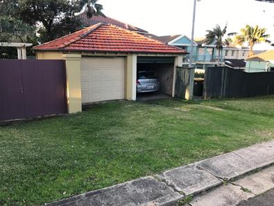
Figure 1: Existing garage on the subject site (left) and neighbouring garage (right)
The property has street frontages of 13.41m and a site depth of 40.235m with a site area of 539.5sqm.
The dwelling is not heritage listed and is not in a conservation area.
The subject property is adjoined on both sides by 2-storey dwelling houses with both having garages along the rear boundary to The Corso. Dwelling houses are located to the north across Torrington Road and to the south across The Corso. Garage and outbuilding structures along the northern (subject side of The Corso) are single storey in scale whilst 2 x 2-storey examples are sited 200m to the east at 77 Torrington Road and 81 Torrington Rd.
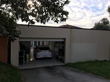
Figure 2: Garage structure at the rear of the western adjoining property
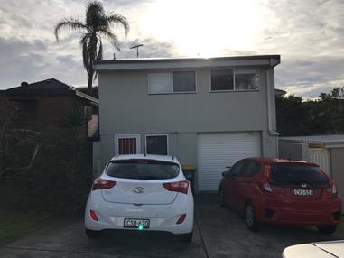
Figure 3: Garage with 2-storey dwelling component at the rear of 81 Torrington Road
Submissions
The owners of adjoining and likely affected neighbouring properties were notified of the proposed development in accordance with the Randwick Comprehensive DCP 2013. The following submissions were received as a result of the notification process:
· 29 Torrington Road, Maroubra
· 33 Torrington Road, Maroubra
|
Issues |
Comments |
|
Height |
The proposal has been amended to comply with the 6m maximum (to the pitch) height for an outbuilding and the 4.5m maximum wall height. The roof form has also been amended to reduce the visual bulk and scale of the secondary dwelling. It is considered that the proposed height of the development is satisfactory. |
|
Privacy |
Amendments to the proposal have recessed the secondary dwelling to align with the adjoining garage to the west. The upper level north-facing openings include privacy louvres to minimise privacy impacts to the western neighbour. The upper level is also associated with a passive use, being a bedroom. The living room is located on the ground floor, further minimising any overlooking impacts. It is therefore considered that the proposal is satisfactory in regard to privacy impacts. |
|
Noise |
It is considered that the residential nature of the secondary dwelling will not generate any unreasonable acoustic impacts upon neighbouring properties.
|
|
Common wall of garage between subject site and 31 Torrington Road |
A structural report has been provided which confirms that the proposed new wall of the garage will be independent of the existing neighbouring wall on the boundary. |
|
Access to neighbouring garages |
A condition of consent has been imposed requiring a Construction Site Management Plan to be implemented to ensure access to neighbouring properties is not affected. |
|
Drainage |
A condition of consent has been imposed requiring details of the proposed stormwater drainage system to be included in the construction certificate for development. Conditions of consent also require a grated drain to be constructed within the site. |
Key Issues
State Environmental Planning Policy (Affordable Rental Housing) 2009
The proposal complies with Division 2 (Secondary Dwellings) of the ARHSEPP 2009.
The subject site is located in the R2 Low Density Residential zone, of which the proposed secondary dwelling is permissible. The amended plans have reduced the total GFA of the secondary dwelling to 59.7sqm, which is compliant with the 60sqm maximum. The proposal also complies with the maximum floor space ratio for dwelling houses having a floor space ratio of 0.63:1.
1. Randwick LEP 2012
The subject site is zoned R2 Low Density Residential under Randwick LEP 2012. The proposal development is classified as a new garage and secondary dwelling and is permissible in the zone. The zoning objectives are addressed as follows:
· To provide for the housing needs of the community within a low density residential environment.
· To enable other land uses that provide facilities or services to meet the day to day needs of residents.
· To recognise the desirable elements of the existing streetscape and built form or, in precincts undergoing transition, that contribute to the desired future character of the area.
· To protect the amenity of residents.
· To encourage housing affordability.
· To enable small-scale business uses in existing commercial buildings.
The proposed new garage and secondary dwelling provides for the housing needs of the community within a low density residential environment.
The proposal is generally consistent with the surrounding low density residential development. The reduced compliant height and GFA of the secondary dwelling has helped to minimize amenity impacts on neighbouring properties including privacy impacts.
Relationship to City Plan
The relationship with the City Plan is as follows:
Outcome 4: Excellence in urban design and development.
Direction 4a: Improved design and sustainability across all development.
Financial impact statement
There is no direct financial impact for this matter.
Conclusion
The proposed development is permissible in the R2 Low Density Residential zone. The proposal is under the LEP height and FSR limit for the subject site. The proposal has been amended to comply with the height limit and FSR limit for secondary dwellings.
Relevant controls and objectives within Randwick DCP 2013 are satisfied and environmental impacts have been assessed as being acceptable, subject to proposed conditions of consent. The scale and design of the amended proposal is considered to be suitable for the location and is compatible with the desired future character of the locality, within the foreshore area. The proposed development satisfies the matters for consideration under Section 79C of the Environmental Planning and Assessment Act 1979, and the relevant legislation, State policies and local planning controls. The application is therefore recommended for approval subject to conditions of consent.
|
That Council, as the consent authority, grants development consent under Sections 80 and 80A of the Environmental Planning and Assessment Act 1979, as amended, to Development Application No. 281/2017 for proposed double garage and adjoining 2 storey studio development, at No. 31 Torrington Road, Maroubra, subject to the following non standard conditions and the standard conditions contained in the development application compliance report attached to this report:
Non standard conditions Amendment of Plans & Documentation 2. The approved plans and documents must be amended in accordance with the following requirements:
a. A Construction Management Plan shall be provided to allow for the following:
· Unobstructed driveway access to be maintained during and post construction to the neighbouring garages/driveways either side of the subject site.
· The structural integrity of the adjoining garages is to be maintained during demolition and construction. Structural details are to be in accordance with the structural statement prepared by E.E.C dated 27th July 2017.
b. The new driveway crossing shall be designed to avoid diversion of overland flow of stormwater to the property to the east.
c. A minimum 150mm wide grated drain is to be constructed, within the site, along the garage door entrance in The Corso with the grated drain pipework discharging to the Torrington Road frontage. Details are to be shown on the plans submitted for the Construction Certificate and be approved by the Certifying Authority.
|
|
1.⇨ |
DA Compliance Report - 31 Torrington Road, MAROUBRA |
Included under separate cover |
Planning Committee 14 November 2017
Development Application Report No. D80/17
Subject: 299 Storey Street, Maroubra (DA/493/2017)
Folder No: DA/493/2017
Author: Willana Associates, Pty Ltd
Proposal: Alterations and additions to the existing dwelling and conversion to a dual occupancy with associated works including infill of swimming and spa pools (variation to floor space ratio control)
Ward: Central Ward
Applicant: Corona Projects Pty Ltd
Owner: Mr Z Q Zhang & Mrs L H Gu
Summary
Recommendation: Refusal
|
|
|
|
Subject Site |
|
|
|
|
|
|
|
|
|
|
|
|
|
|
Submissions received
|
|
|
Ù North
|
|
|
Locality Plan |
Development Application Executive summary report
The application is referred to the Planning Committee for determination as Clause 4.6 is greater than 10%.
Proposal
The proposal involves the alterations and additions to the existing dwelling and conversion to an attached dual occupancy with associated works including infill of the swimming and spa pools (variation to floor space ratio control). The proposal includes a number of alterations and additions over each level of the building which are unauthorised, with a comparison of the existing dwelling and proposed development provided in the table below:
|
Level |
Existing/ Approved |
Proposed Modifications/ As-Built but Unauthorised |
|
Subfloor (Level 1) |
Subfloor, laundry with internal stairs to upper level |
Unit 2: Enclosure of sub-floor with new external walls to create Bedroom 3 (with ensuite), internal stairs up from Bedroom 3 to new Bedroom 1, Bedroom 4, study#, bathroom 1, bathrooms 2 (with linen cupboard), unnamed circulation space, hallway and new entry from eastern side of dwelling. |
|
Garage (Level 2) |
Kitchen / meals, cool room, storeroom, Bedroom 7/ Servant’s Bedroom with toilet, 5 car garage, Bedroom 6, sauna, bathroom, games and rumpus rooms |
Unit 1: Convert storeroom, Bedroom 7/ Servant’s Bedroom with toilet into cellar# and plant room; replace cool room for with 2 x car spaces.
Unit 2: Renovate kitchen, convert games/ rumpus rooms into dining room, living room and new study, retain sauna, convert bathroom into dressing room with external doorway, replace bedroom 6 with parking space for unit 2, fill in existing pool and spa and use as dedicated private open space for Unit 2. It is also proposed to remove several existing and unauthorised partition walls in the proposed living room and garage. |
|
Street Level (Level 3) |
Portico and entry, foyer with spiral stair case to upper levels, kitchen, pantry, stairs to lower level, formal dining, formal lounge, family room, separate toilet, Bedroom 5 with ensuite and rear balcony accessed via the dining and living rooms with stairs to the pool and deck below. |
Unit 1: Portico and entry, foyer with spiral stair case to upper levels, kitchen, pantry, stairs to lower level bricked up, dining, formal lounge used as living room, internal wall to divide family room into a new study (accessed from main foyer) and TV room# (accessed from new doorway off dining room, separate toilet and Bedroom 5 with ensuite retained as is. The external stairs from the rear deck to the Private Open Space for Unit 2 are to be retained. |
|
Level 4 |
Foyer with spiral stair case down to Level 3 and up to the roof terrace, study with large void to formal lounge below, Master Bedroom with ensuite and WIR and wraparound terrace connecting with the study, separate balcony to eastern elevation of the study, Bedroom 2 with ensuite, two linen cupboards, Bedroom 3, separate bathroom and Bedroom 4. |
Unit 1: As existing although study walls appear to have been removed and reconfiguration of linen cupboards has occurred at some point in time. |
|
Level 5 (roof) |
Roof terrace accessed by spiral stairs. |
No change. |
Note: Rooms denoted with # are considered capable of being used as a bedroom, although denoted on the plans for other purposes.
The application also proposes several other works including the filling of the existing pool and spa to create the private open space for Unit 2 (on Level 1); utilization of an unauthorised and non-compliant staircase running along the eastern side boundary over an existing drainage easement for external access into Unit 2; and installation of a vehicle turntable in the basement garage.
The plans are also of quite poor clarity in that they fail to distinguish the existing, approved building from the unauthorised works and the proposed works. It is also apparent that the proposal would not function as proposed. Bedroom 3 on Level 1 (sub floor) is not connected internally to Unit 2 and could easily function independently of either unit. Likewise, the cellar to unit 1 (former servant’s bedroom and ensuite) has no direct link to either unit and can easily operate independently of the remainder of the building.
Site
The site is known as 299 Storey Street, Maroubra and is located on the southern side of the street. The lot is legally described as Lot 1 within Deposited Plan 594649.
The site has a frontage to Storey Street of 15.5m and a depth of 35.38m. The site has a slope from the north to the south of approximately 8m. The total area of the site is 786.6m2. The site currently contains a four storey dwelling house that is the subject of this DA.
Submissions
The owners of adjoining and likely affected neighbouring properties were notified of the proposed development in accordance with the Randwick Comprehensive DCP 2013. The following submissions were received as a result of the notification process:
286 Storey St, Maroubra
|
Issues |
Comments |
|
The residence is used as short term accommodation that is incompatible with the area and could pose a safety risk. |
The alleged use of the premises is subject to separate enforcement processes before Council. The enforcement processes are also, in part, dependent upon the outcome of the subject DA. Notwithstanding this, the application before Council seeks consent for alterations and additions to the existing dwelling and conversion of the dwelling to create an attached dual occupancy. The proposed works and use are permissible with the consent of Council under the provisions of the Randwick Local Environmental Plan 2012. The objector has not however, supplied any evidence to indicate any antisocial activities in the local area linked to the alleged use of the premises. |
|
There will be additional people living at the premises which will impact on the availability of on-street parking.
|
The proposal will result in additional people residing at the property. Council’s planning controls require each development provide adequate on-site car parking to cater for the likely demand for parking. In this instance, the proposal is required to provide two parking spaces for each dwelling, which has been complied with. |
288 Storey St Maroubra
|
Issues |
Comments |
|
Rubbish and debris from construction of the original dwelling was not secured and blew across the neighbourhood. |
While this matter is not relevant to the current application, suitable conditions regarding the control of construction waste can be included in any approval issued in respect of the proposal. |
|
The dwelling is currently used as an unauthorised place of short term stay accommodation (AirBnB). The residents park their cars on the street in front of other properties. |
As discussed previously, the alleged unauthorised use is a separate enforcement matter that is not directly relevant to the current proposal. While each development must be assessed on its merits against the applicable planning controls, adequate on-site parking must also be provided and be both accessible and utilised. In this instance, the proposal satisfies Council’s on-site parking requirements, however other factors, such as the use of the garage for the storage of goods or the perceived narrowness and gradient of the existing driveway, appear to impact on the ability of the occupants to utilise that car parking at present. |
Key Issues
Floor Space Ratio – Clause 4.6 Exception
The proposal seeks to vary a development standard contained within the Randwick Local Environmental Plan 2012 (RLEP 2012). A Clause 4.6 exception has been submitted to Council.
Pursuant to Clause 4.4 of the RLEP 2012, the floor space ratio of the building must not be more than 0.5:1 on the site. A floor space ratio of 0.98:1 is proposed, increasing from 0.77:1 at present.
The proposed variation is summarised in the table below:
|
|
Floor Space Ratio |
|
Development Standard |
0.5:1 |
|
Existing Proposed |
0.77:1 0.98:1 |
|
Excess above the standard |
96% (of which 57% already exists) |
The applicant has submitted a written request seeking to justify the contravention of the standard pursuant to Clause 4.6 of RLEP 2012: Exception to a Development Standard.
Clause 4.6 RLEP 2012 Request to Vary a Development Standard
Clause 4.6 of the RLEP provides a mechanism to seek a variation to a development standards in certain circumstances.
Assessment of the Applicant’s Written Justifications for the Contravention of the Development Standard
Pursuant to clause 4.6(3) of RLEP 2012, development consent must not be granted for development that contravenes a development standard unless the consent authority has considered a written request from the applicant that seeks to justify the variation by demonstrating:
1) that compliance with the development standard is unreasonable or unnecessary in the circumstances of the case, and
2) that there are sufficient environmental planning grounds to justify contravening the development standard.
Further, the consent authority must be satisfied that:
(i) the applicant's written request has adequately addressed the matters required to be demonstrated by subclause (3), and
(ii) the proposed development will be in the public interest because it is consistent with the objectives of the particular standard and the objectives for development within the zone in which the development is proposed to be carried out
The concurrence of the Director-General of the Department of Planning and Infrastructure must also be obtained for development that contravenes a development standard. However, pursuant to the Notification of assumed concurrence of the Director-General under clause 4.6(4) (and the former clause 24(4)) of the Standard Instrument contained in Planning Circular PS 08-003 (dated 9 May 2008) the concurrence of the Director-General of the Department of Planning and Environment under clause 4.6(4) (b) of RLEP 2012 may be assumed in certain cases.
In relation to the matters required to be demonstrated by sub clause (3), there are various ways that may be invoked to establish that compliance with a development standard is unreasonable or unnecessary as discussed by Chief Justice Preston of the NSW Land and Environment Court in the case of in Wehbe v Pittwater Council [2007] NSWLEC 827. Although the Wehbe case was decided in relation to State Environmental Planning Policy No 1-Development Standards ("SEPP 1") and not clause 4.6 of RLEP 2012 it remains of some assistance in relation to identifying the ways in which an applicant may demonstrate that compliance with a development standard is unreasonable or unnecessary in the circumstances of the case.
Has the applicant’s written request adequately addressed that compliance with the development standard is unreasonable or unnecessary in the circumstances of the case?
In the Wehbe case Justice Preston said the most commonly invoked way to establish that compliance with a development standard is unreasonable or unnecessary is to demonstrate that the objectives of the development standard are achieved notwithstanding non-compliance with the standard.
The stated objectives of the RLEP which apply to floor space ratio are:
(a) to ensure that the size and scale of development is compatible with the desired future character of the locality,
(b) to ensure that buildings are well articulated and respond to environmental and energy needs,
(c) to ensure that development is compatible with the scale and character of contributory buildings in a conservation area or near a heritage item,
(d) to ensure that development does not adversely impact on the amenity of adjoining and neighbouring land in terms of visual bulk, loss of privacy, overshadowing and views.
The applicant’s written justification for the variation are as follows:
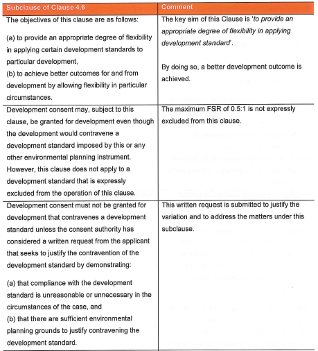
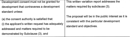
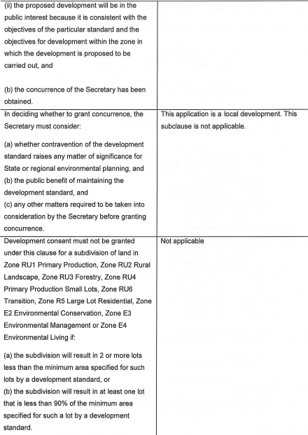
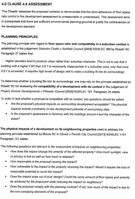
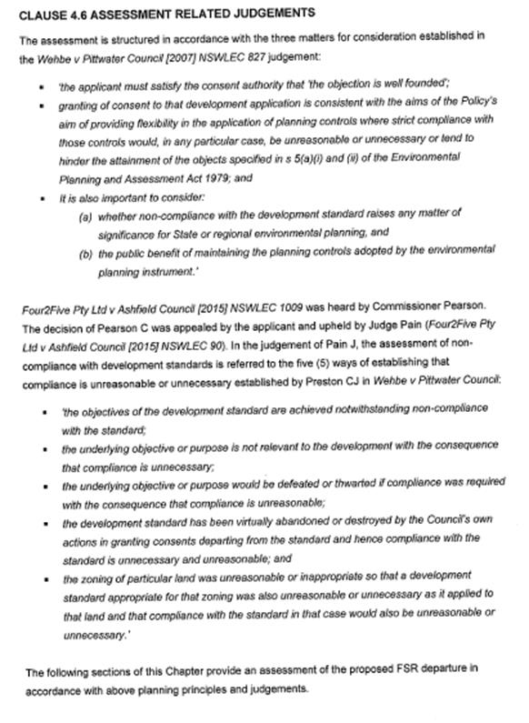
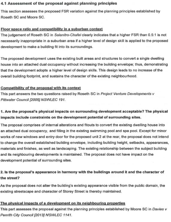
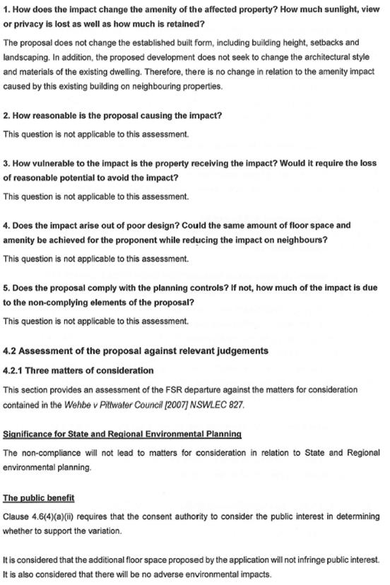
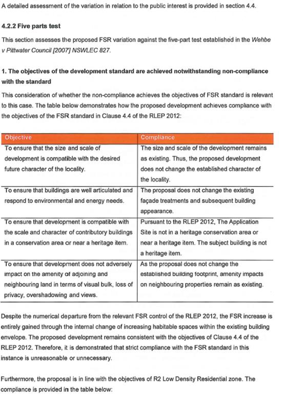
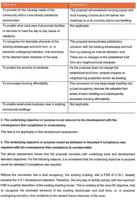
Assessing Officer’s Comments:
The existing dwelling is a significant structure that has been constructed with irregular room shapes, angles and sizes, albeit with little regard for the Site’s topography. It contains several large balconies, including an expansive roof-top open space are and a number of major habitable rooms over five levels. The existing building has however been clearly designed to function as a large, single dwelling.
By introducing a new land use, a dual occupancy development, the standards are somewhat different to those applicable to a detached dwelling house, notwithstanding the proposal involves utilising the subfloor and reallocating internal spaces.
as the applicant’s written request adequately addressed that compliance with the development standard is unreasonable or unnecessary in the circumstances of the case?
No. The applicant’s written request does not adequately demonstrate that compliance is unreasonable or unnecessary in the circumstances of the case.
In determining what constitutes unreasonable or unnecessary, it is a well-established practice to ask a series of questions, as follows:
(a) Would the proposal, despite numerical non-compliance, be consistent with the relevant environmental or planning objectives?
(b) Is the underlying objective or purpose of the standard not relevant to the development thereby making compliance with any such development standard is unnecessary?
(c) Would the underlying objective or purpose be defeated or thwarted were compliance required, making compliance with any such development standard unreasonable?
(d) Has Council by its own actions, abandoned or destroyed the development standard, by granting consent that depart from the standard, making compliance with the development standard by others both unnecessary and unreasonable?
(e) Is the “zoning of particular land” unreasonable or inappropriate so that a development standard appropriate for that zoning was also unreasonable and unnecessary as it applied to that land? Consequently, compliance with that development standard is unnecessary and unreasonable.
In response to the first question, or ‘test’, the proposal is inconsistent with the objectives of the R2 Low Density Residential zone. The objectives relevant to the proposal are as follows:
· To provide for the housing needs of the community within a low density residential environment.
· To protect the amenity of residents.
· To encourage housing affordability.
Having regard to these objectives, the proposal is deemed to be inconsistent, as follows:
· While the proposal provides additional housing, it is not in the context of a low density residential environment. Clearly, at [24] – [27] in Salanitro-Chafei v Ashfield Council [2005] NSWLEC 366, which the applicant cites as justification for the proposed FSR, an FSR of 0.5:1 is deemed to be commensurate with the desired residential character and not one in the order of 0.98:1. Such a density is reflective of higher density area and does not ensure an appropriate level of amenity, notwithstanding the majority of works are within the existing building envelope.
· The proposal will not ensure that the amenity of residents is protected. The design of the existing building (and hence the layout of the proposal) is such that the private open space allocated to Unit 2 would be significantly compromised by overlooking by the residents of Unit 1 from the roof top open space, rear balconies on two levels and the associated main habitable rooms. Additionally, the position of the unauthorised and non-compliant stairs along the eastern boundary means that overlooking of the adjoining windows, rear balcony and rear private open space would be possible as pedestrians enter and leave Unit 2. Further, the proposal also retains the existing stairs from the rear balcony of Unit 1 on Level 3 directly into the private open space for Unit 2. The application fails to provide any landscaping or privacy screening (or any other mitigative measures) to ensure adequate privacy is maintained.
· The applicant’s argument that the “conversion of one large single dwelling into a dual occupancy reduces the saleable floor area of each dwelling and subsequently increases housing affordability” is not supported. The dual occupancy does not propose subdivision and in fact, it proposes a significant uplift in gross floor area, well above the stipulated limit, instead of reducing it. Effectively, the proposal results in a change from a seven bedroom dwelling to a building containing seven designated bedrooms across two units and a further four rooms that are capable of being used as bedrooms. Further, the configuration of Bedroom 3 (Unit 2) and the cellar for Unit 1 (former servant’s bedroom/ ensuite) are such that they can operate independently of either unit and do not have any internal connection to their respective units.
With regard to the second ‘test’, the underlying objective or purpose of the standard remains relevant to the proposal, thereby making compliance with the floor space ratio development standard necessary.
In terms of the third ‘test’, the underlying purpose of the standard has not been defeated or thwarted, notwithstanding that the FSR of the existing dwelling exceeds the current maximum of 0.6:1 for single dwellings on allotments exceeding 600m2, pursuant to Clause 4.4(2A)(c) of the RLEP 2012. It is understood that the subject dwelling was approved and built prior to the imposition of an FSR control on single dwellings. Further, the construction of Clause 4.4 of the RLEP 2012 is clear there is a distinction between the density and design controls that apply to detached dwellings as opposed to dual occupancy development. The argument that a substantial breach of the FSR control is acceptable because you cannot readily see the additional density because it is contained within the existing building is simplistic, ignores the significant amenity issues present and does not demonstrate the proposal and variation of the FSR development standard, results in a better planning outcome.
In relation to the fourth ‘test’, Council has not abandoned or destroyed the development standard (whether intentional or not) and that approval of the proposal will create an undesirable precedence.
In relation to the fifth ‘test’, it is contended that the zoning of the land is appropriate to provide for low density residential development of a scale that is commensurate with the designated FSR of 0.5:1.
The applicant also contends that in order to be fully compliant with the 0.5:1 FSR development standard, part of the existing dwelling would need to be demolished. This is not supported. Firstly, the applicable FSR control for a detached dwelling on an allotment exceeding 600m2 is 0.6: 1, as discussed above, whereas a dual occupancy is required to be no greater than 0.5:1. Secondly, Council cannot require an existing, approved structure be demolished in order to comply with the controls that currently apply.
Has the applicant’s written request adequately addressed that there are sufficient environmental planning grounds to justify contravening the development standard?
No. The applicant’s written request does not demonstrate to the satisfaction of Council that there are sufficient environmental planning grounds to justify the variation.
As demonstrated above, the proposal fails to adequately achieve the objectives of Clause 4.4 of the RLEP 2012 as follows:
Objective:
(a) to ensure that the size and scale of development is compatible with the desired future character of the locality,
The scale of the proposal is not compatible with the desired future character of the locality. The proposal results in a FSR of 0.98:1, which is almost double that which is deemed appropriate for the R2 – Low Density Residential zone. The RLEP 2012 defines the general character of the R2 – Low Density Residential zone through a combination of height, FSR and minimum allotment size controls. This is reinforced by the building envelope controls in the RDCP 2013 as well as other provisions relating to setbacks, site coverage, landscaping and private open space. In addition, the general amenity considerations relating to privacy and solar access/ overshadowing also help define the desired future character of the low density residential areas.
In this instance, as demonstrated below, the scale of the proposal is inappropriate for the surrounding locality, notwithstanding the new dwelling will be largely encapsulated within the existing building footprint. The proposal fails to ensure an adequate level of amenity for an additional dwelling on the subject site and sets an undesirable precedent for further infill development of a similar nature where residential amenity is significantly compromised.
It is noted that the applicant cites Salanitro-Chafei v Ashfield Council [2005] NSWLEC 366 in relation to FSR and the compatibility in a suburban context. In that case, the applicant sought (and was refused consent by the Court), to demolish an existing dwelling and construct a new dwelling in an area which lacked a definitive FSR control. This context is somewhat different to the subject site and DA. Although the subject site has a maximum FSR of 0.5:1 for an attached dual occupancy development, a dwelling is permitted a higher FSR of 0.6:1 on an allotment greater than 600m2 in area, reflecting the need to accommodate two dwellings and their associated spaces and setbacks.
The Court also found in the case of Salanitro-Chafei that it is generally accepted an FSR around 0.5:1 reflects an open suburban character and higher densities (around 0.9:1) reflect an urban, medium density character. The Court also held at [29] that it was therefore critical a building exceeding 0.5:1 contained a high degree of design skill to make the proposal fit into its surroundings. A building’s “fit” also depends on whether it results in an adverse impact on the surrounding residential amenity as a consequence of its design and layout.
The applicant contends that a higher density (such as is proposed) is appropriate for a site that is restricted to an FSR of 0.5:1. The applicant has failed to demonstrate this by virtue of the non-compliances relating to poor internal and external privacy, inadequate solar access and natural ventilation, excessive site coverage, lack of sufficient landscaping and deep soil areas, poor internal layout and design, inadequate pedestrian access to Unit 2 and lack of adequate laundry and clothes drying facilities.
Objective:
(b) to ensure that buildings are well articulated and respond to environmental and energy needs,
While the building presents an unusual degree of articulation and overall design, it could hardly be seen to respond to the existing site constraints. The infill of space below a large cantilevered deck is not an appropriate response to the site constraints or orientation as the new dwelling will be located partly below natural ground level and on the southern side of the house. The subfloor level will not receive adequate natural ventilation or solar access and in presents an inefficient layout as a consequence of the unauthorised works and unusual foundation of the existing structure.
Objective:
(c) to ensure that development is compatible with the scale and character of contributory buildings in a conservation area or near a heritage item,
This is not relevant to the proposal as the proposal is not in a conservation area and is not near a heritage item.
Objective:
(d) to ensure that development does not adversely impact on the amenity of adjoining and neighbouring land in terms of visual bulk, loss of privacy, overshadowing and views.
As demonstrated below, the proposal will not ensure an adequate level of internal or external privacy or solar access. The applicant has not identified any mitigative or preventative measures to ensure the occupants of unit 1 will not be able to overlook the private open space of unit 2 or that there will be no greater loss of amenity to adjoining properties as a consequence of additional people at the property being able to look into the private open space areas and habitable rooms of adjoining dwellings. The lack of any landscaping or in fact opportunities for landscaping leads to a greater loss of amenity for neighbouring properties.
Overall, the applicant’s Clause 4.6 submission and SEE have failed to justify the proposal in terms and demonstrate that there are sufficient environmental planning outcomes by demonstrating a satisfactory level of compliance with the design controls contained in the RDCP 2013. Additionally, the supporting documents do not demonstrate that the proposal will result in a better planning outcome in the context of the provisions of Section 79C(1)(a)(iii), (b) and (c) of the Environmental Planning and Assessment Act 1979, with respect to the provisions the RDCP 2013, the amenity impacts and the suitability of the site for the proposal.
Will the proposed development be in the public interest because it is consistent with the objectives of the particular standard and the objectives for development within the zone in which the development is proposed to be carried out?
No, the proposed development is not in the public interest as it is not consistent with the objectives of the floor space ratio standard of the RLEP 2012 or the relevant objectives for development within the R2 – Low Density Residential zone.
The proposal’s failure to achieve the objectives of the FSR development standard or the objectives of the R2 – Low Density Residential zone have been discussed previously. Having regard to the unusual nature and design of the proposal, the following additional observations are made insofar as the development is not in the public interest:
· the need for additional low-density housing choices is reflected in development that provides adequate setbacks, internal and external amenity, adequate private open spaces and landscaped areas;
· the internal layout of the development is both inefficient and is not conducive to functioning as intended. This will lead to substandard residential accommodation and impact on the health and well-being of the wider community, as well as the occupants;
· The proposed density and scale of development is not compatible with the desired future character of the locality by virtue of the FSR being more appropriate for a higher density in a town centre.
· The proposal does not result in a development that provides a suitable level of amenity vis natural ventilation, privacy, solar access or a layout/ internal design that promotes an efficient and liveable residential environment.
· The density and number of people the proposal can accommodate will result in an intensity that will exacerbate existing poor-amenity outcomes caused by overlooking of adjacent properties.
Does the Council have delegation to exercise the concurrence function of the Director-General of the Department of Planning and Infrastructure for development that contravenes a development standard? If so:
(a) whether contravention of the development standard raises any matter of significance for State or regional environmental planning, and
(b) the public benefit of maintaining the development standard.
Comments:
Pursuant to the Notification of assumed concurrence of the Director-General under clause 4.6(4) (and the former clause 24(4)) of the Standard Instrument contained in Planning Circular PS 08–003 (dated 9 May 2008)) the concurrence of the Director-General of the Department of Planning and Environment under clause 4.6(4)(b) of RLEP 2012 may be assumed for the proposed contravention to the maximum floor space ratio control. The proposed development and variation from the standard does not raise any matters of significance for State or regional environmental planning.
At face value, the application seeks to undertake largely internal modifications to an existing dwelling to create an attached dual occupancy development within the footprint of the building. While the proposal might appear to be innocuous, it belies the recent history of alleged unauthorised use and works at the property to convert the subfloor area into additional habitable space. Notwithstanding this, the departure from the maximum FSR standard on this occasion is not considered to be of benefit to the orderly use of the site and there is no public benefit in varying the development standard in this instance.
Overall, the application appears to be relying on unauthorised works and a misconception that existing non-compliances and breaches of development standards in the context of a single dwelling, will facilitate an acceptable outcome for a dual occupancy development. The proposal will not result in an acceptable planning outcome or ensure future residents are provided with an adequate level of amenity.
Relationship to City Plan
The relationship with the City Plan is as follows:
Outcome 4: Excellence in urban design and development.
Direction 4a: Improved design and sustainability across all development.
Financial impact statement
Council may wish to pursue enforcement action against the land owner regarding the alleged unauthorised use and works, which may incur costs. If the applicant chose to appeal Council’s decision in the NSW Land and Environment Court, Council would need to defend its decision and engage legal counsel to assist with the defence.
The application results in a significant variation to the maximum floor space ratio imposed by the RLEP 2012, of 0.5:1, proposing 0.98:1. The existing dwelling has an FSR of 0.78:1, which exceeds the current limit of 0.6:1 for allotments greater than 600m2 in area. The applicant proposes to utilise existing subfloor and partial basement garage level to provide the new dwelling (Unit 2), retaining the majority of the existing dwelling as Unit 1.
Aside from the significant variation to the FSR development standard, the application also fails as follows:
· The site coverage exceeds the maximum of 45% (approximately 80%);
· The deep soil areas are less than 35% of the site area (approximately 10%);
· The private open space area for Unit 2 is overlooked by main living rooms and the rear decks of Unit 1 while the only private open space area having suitable dimensions for Unit 1 is remotely located on the rooftop;
· The private open space for Unit 2 does not receive adequate solar access;
· Side setbacks are inadequate for dual occupancy development to ensure adequate landscaping, privacy and overall amenity;
· Pedestrian access to Unit 2 is not directly visible from the street and lacks adequate passive surveillance and is not connected to any living rooms and is also via a non-compliant stair along the eastern boundary, impacting on the privacy of the adjoining dwelling;
· Adequate solar access to the living rooms of Unit 2 cannot be achieved;
· Unit 2 does not have adequate natural ventilation due to the orientation, poor and inefficient internal layout and window placements; and
· Unit 1 is not provided with a laundry and no details are provided of the location of clothes drying areas for either dwelling.
Overall, the proposal results in a substandard development which will not ensure an adequate level of residential amenity and create an unacceptable precedence for similar dwelling conversions.
The application is, therefore, recommended for refusal for the reasons listed below.
|
That Council, as the consent authority, refuse development consent under Sections 80 and 80A of the Environmental Planning and Assessment Act 1979, as amended, to Development Application No. DA/493/2017 for alterations and additions to the existing dwelling and conversion to a dual occupancy with associated works including infill of swimming and spa pools (variation to floor space ratio control), at No. 299 Storey Street, Maroubra for the following reasons:
1) The proposal fails to satisfy the relevant objectives of R2 – Low Density zone under Randwick Local Environmental Plan 2012 in relation to the desired future character of the locality and the protection of residential amenity.
2) The proposal exceeds the maximum floor space ratio of 0.5:1 specified in Clause 4.4 of Randwick Local Environmental Plan 2012 and the Clause 4.6 variation to the development standard does not adequately demonstrate that strict application of the control is either unreasonable or unnecessary or that there are sufficient environmental planning reasons to justify contravening the development standard.
3) Approval of such a significant variation to the floor space ratio development standard without satisfactory justification as required by Clause 4.6(3) of the of Randwick Local Environmental Plan 2012 would not be in the public interest as it is inconsistent with the objectives of the floor space ratio development standard and the objectives for development within the R2 – Low Density zone in which the development is proposed to be carried out.
4) The proposal fails to satisfy the relevant objectives of Building Design under Part C1 of the Randwick Comprehensive Development Control Plan 2013 in that the excessive height and density, lack of adequate solar access and privacy, excessive site coverage, lack of adequate private open space, lack of adequate deep soil zones, poor internal layout, lack of adequate laundry and clothes drying facilities, poor pedestrian access and lack of adequate natural ventilation would result in unreasonable impacts for the future residents of the development in terms of overall residential amenity, privacy and solar access.
5) The proposal does not comply with the landscape and permeable surface requirements under Part C1 of the Randwick Comprehensive Development Control Plan 2013.
6) The proposal does not achieve adequate side and rear setbacks for dual occupancy development under Part C1 of the Randwick Comprehensive Development Control Plan 2013, resulting in to inadequate solar access, private open space, privacy and residential amenity.
7) The proposal does not satisfy the visual privacy requirements under Part C1 of the Randwick Comprehensive Development Control Plan 2013 because it would result in unreasonable internal privacy impacts as a consequence of overlooking from the living rooms and rear balconies of Unit 1 directly over the private open space area for Unit 2, as well as an unacceptable loss of privacy to the adjoining dwelling at 301 Storey Street by people using the non-compliant stairs along the eastern boundary.
8) Private open space which achieves suitable dimensions for Unit 1 is not directly accessible from living rooms within the dwelling, is located only on the rooftop and in such a manner that direct overlooking of adjoining dwellings occurs and is not provided with any landscaping to ensure an adequate level of amenity or utility.
9) The proposal would result in inadequate levels of internal amenity due to a lack of solar access to the living rooms and private open space areas of Unit 2 and poor natural ventilation due to the setbacks, orientation, poor internal floor layout and inadequate window design and placement.
10) Pedestrian access to Unit 2 is inadequate as it cannot be easily seen from the street, can only be accessed via a non-compliant stairway and indirect path of travel within the lower level of the dwelling and is not provided with an acceptable level of passive surveillance from the public domain.
11) The development will not provide adequate facilities for each dwelling with Unit 1 not being provided with a laundry and neither Unit 1 or 2 being provided with any defined location for the drying of clothes.
12) The approval of a development with poor levels of internal amenity, inadequate facilities and private open space areas, poor natural ventilation and inadequate solar access despite such a significant density which is well above the stipulated floor space ratio is not in the public interest and will set an undesirable precedent for other similarly inadequate proposals, resulting in a significant adverse effect on the wider health and wellbeing of the community. |
|
1.⇨ |
DA Compliance Report - DA/493/2017 - 299 Storey Street, MAROUBRA |
Included under separate cover |
Planning Committee 14 November 2017
Development Application Report No. D81/17
Subject: 213 Bunnerong Road, Maroubra (DA/237/2017)
Folder No: DA/237/2017
Author: Louis Coorey, Senior Environmental Planning Officer
Proposal: Retention of portion of structure of existing dwelling and incorporation into construction of part two part three (attic) storey boarding house containing 11 boarding rooms, communal facilities, parking for 3 cars, motorcycle and bicycle parking, landscaping and associated works
Ward: South Ward
Applicant: MKD Architects Pty Ltd
Owner: Ms E Exindaris
Summary
Recommendation: Approval
|
|
|
|
Subject Site |
|
|
|
|
|
|
|
|
|
|
|
|
|
|
Submissions received
|
|
|
Ù North
|
|
|
Locality Plan |
Development Application Executive summary report
The application is reported to the Planning Committee at the request of Councillors D'Souza, Stavrinos and Andrews.
Proposal
Retention of portion of structure of existing dwelling and incorporation into construction of part two part three (attic) storey boarding house containing 11 boarding rooms (14 lodgers), communal facilities, parking for 3 cars, motorcycle and bicycle parking, landscaping and associated works.
Amended plans and additional details
Amended and additional details received 26 July 2017 comprising the following:
· Acoustic report as requested by Council’s Senior Environmental Health Officer
· Relocate entry to the northern side off Bunnerong Road and co-locate with communal area to improve casual surveillance of the street
· Limit underground garaging to two vehicles and one space in rear yard inclusive of bicycle and motor cycle parking;
· Remove retaining walls along southern side retaining existing ground levels
Site
The site is a corner allotment having a rectangular skewed boundary (12.365m) fronting Bunnerong Road and secondary frontage (42.67m) to Eastmore Place, a southern side boundary depth of 45.11m and a total site area of 532.1sqm.
The site currently contains a brick duplex residence and brick garages under most of which will be demolished except for the lower ground level garaging by way of the proposal. The subject site slopes down from west to east From Bunnerong Road down along Eastmore Place, characteristic of the natural land fall on land on neighbouring properties.
Adjoining the site to the south is a part three/part four level residential flat building at No. 215 Bunnerong Road with garaging located at the lower ground level at the rear where the land is at its lowest level. Opposite the site to the north is a part two/part three storey dwelling at No. 211 Bunnerong Road fronting with a double garage accessible off the laneway.
The locality comprises predominantly low to medium density residential development within the R2 low density residential zone. The buildings in the locality include single 2 and part three storey dwelling houses as well as some older multi (part 2/3 & 4) storey residential flat developments.
The site is in close proximity to public transport bus services along Bunnerong Road and Snape Park within 400m of the site.
An aerial is shown on the cover page of this report and photos below show the subject site, and surrounding developments.
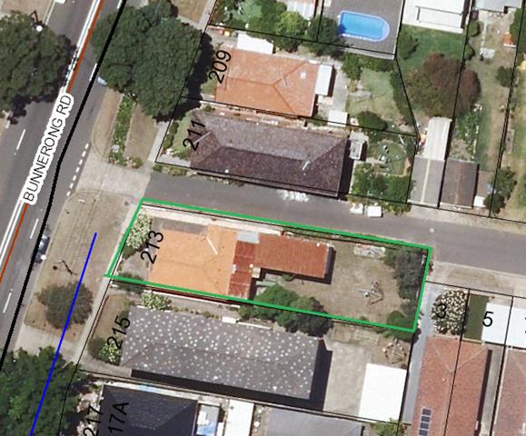
Aerial view of the subject site and neighbouring properties.
Submissions
The owners of adjoining and likely affected neighbouring properties were notified of the proposed development in accordance with the Randwick Comprehensive DCP 2013. The following submissions were received as a result of the notification process:
· 5 Marjorie Crescent, Kingsford
· 6 Marjorie Crescent, Kingsford
· 8 Majorie Crescent, Kingsford
· 12 Marjorie Crescent, Kingsford
· 16 Marjorie Crescent, Kingsford (x2)
· 1 Storey Street, Kingsford
· 17 Storey Street, Kingsford (x3)
· 19 Storey Street, Kingsford (x 3)
· 3 Eastmore Place, Kingsford (x2)
· 9 Eastmore Place, Kingsford
· 11 Eastmore Place, Kingsford
· 15 Eastmore Place, Kingsford
· 19 Eastmore Place, Kingsford (See D02939251)
· 19 Eastmore Place, Kingsford
· 23 Eastmore Place, Kingsford
· 209 Bunnerong Road, Kingsford
· 211 Bunnerong Road, Kingsford
· 2/215 Bunnerong Road, Kingsford
· Units 1, 3, 5 & 6 - 215 Bunnerong Road, Kingsford
· 4/215 Bunnerong Road, Kingsford
· PETITION - 71 signatures
· Unknown address
|
Issue |
Comment |
|
The proposed development is out of character with development in the surrounding area |
See assessment against the character test required under ARHSEPP. In brief the proposed development has a bulk and scale that is not inconsistent with the bulk and scale envisaged under the RLEP for the site and the surrounding area. IN terms of compatibility of use, the proposed boarding house is for residential purposes and permissible under the local planning provisions in the Randwick Local Environmental Plan and the state provisions in the SEPP - Affordable Rental Housing ARHSEPP. |
|
The proposed development will have an adverse social impact associated with residents on a temporary basis and raises the potential for crime and anti-social behaviour. |
Affordable housing is vital element for sustaining a functioning city. It provides much needed housing for Key workers that need to service our City. It allows for social inclusion within established communities with good access to essential services and employment opportunities. There is no evidence to support the claim that residents of low to moderate incomes would pose a threat to the local community. |
|
The proposed boarding house will have an adverse impact in relation to noise and use of common open space. |
The premises are subject to management practices that will serve to ensure that the quiet enjoyment of the neighbouring properties will be reasonably protected. Additional conditions are also included to restrict use of the communal spaces so that they don’t occur between the hours of 9pm and 7am when sleep disturbance is more likely to occur (between 10pm and 7am).
An acoustic report was submitted indicating that the premises and equipment will operate within acceptable noise levels. Additional conditions have also been recommended for inclusion by Councils Senior Environmental Health Officer to minimise noise disturbance. |
|
The proposed boarding house will result in increased waste and what provisions are being made for waste, recycling and composting |
The proposed boarding house provides adequate space for the waste and recycling that is likely to be generated on site and suitable conditions are included in relation to waste collection. There are no regulations requiring composting to be provided for any form of development. |
|
The proposal will result in adverse impacts on parking and traffic in the surrounding area |
Council’s Development Engineer has considered the proposed parking on site and raises no objections on the grounds of accessibility, or safety. There are already two spaces servicing the dwelling accessible off Eastmore Place and the proposal merely maintains this access albeit with improved widths for access.
In terms of supply, the proposed parking for the boarding house complies with the ARHSEPP standards for parking. The ARHSEPP explicitly prohibits Council from refusing an application on parking grounds if it meets those standards. It is also important to consider that the premises meets the criteria as an accessible site as it is within 400m of both an accessible transport route and a town centre thus lessening the need for vehicle ownership by lodgers.
It is also important to explain that the parking requirements under the SEPPARH provide a strong emphasis on encouraging environmental sustainable transport opportunities particularly in localities where public transport infrastructure is frequented and facilities and services are available to meet the day-to-day needs of the residents. The proposal complies with the sustainable transport principles and defined as an accessible site under the ARHSEPP. |
|
The entry passage on the southern side will require lighting and has the potential to impact on the residents at No. 215 Bunnerong Road. |
The entry has been relocated to the northern western corner of the site assisting with casual surveillance. Also a condition is included stating that external lighting to the premises must be designed and located so as to minimise light-spill beyond the property boundary or cause a public nuisance. |
|
The proposed development will cause loss of natural light and solar access to the north facing apartments, clothes line and garden beds in 215 Bunnerong Road, |
See key issues below – in short the north facing windows of No. 215 Bunnerong Road will receive the minimum 3 hours required under the RDCP for low density development and 2hrs required for apartments under the Apartment Design Guide under SEPP 65 for apartments. The clothes line area will also receive adequate levels of solar access. |
|
The proposed breezeway is an eyesore |
The proposed first floor level of the breezeway will be in the line of sight from the elevated north facing ground level apartment at the rear of No. 215 Bunnerong Road.
The breezeway has a two storey scale which is consistent with the scale of developments envisaged in the R2 low density zone under the RLEP 2012 and the RDCP 2013. The breezeway also has a compliant side setback and shielded from view by the landscaping within the subject site which are the subject of protection measures included as conditions of consent.
Also included as a condition is the requirement for the materials and colours of the breezeway be submitted to Council for approval prior to a Construction Certificate being issued for the development. |
|
The boarding house will application set a precedent for other similar uses in the area therefore transforming the character of the area.
|
Every application is assessed on its merits. It is considered that the subject site is suitable for the proposed use as amended and as conditioned. It will achieve good planning outcome having regard to satisfying the requirements under the SEPPARH and the relevant controls under the RDCP and RLEP. |
|
The proposed breezeway will affect the trees on 215 Bunnerong Road |
Council’s Landscape Development Officer has assessed the surrounding trees and included relevant protection conditions in relation to the root zones and clearance pruning where needed. |
|
Access along the southern side will cause adverse privacy impacts |
The access is relocated along a portion of northern side of the site and natural land levels are retained along the south ensuring no direct line of sight across to the habitable room windows of No. 215 Bunnerong Road. Access off Bunnerong Road is more acceptable having regard to improving casual surveillance, minimising impacts on the neighbouring properties and providing a legible entry to the premises. |
|
Removal of asbestos is done within strict guidelines |
Conditions included in the recommendation |
|
Site is managed appropriately during demolition/excavation and construction. |
Suitable conditions are included in the recommendation |
|
Structural integrity of neighbouring properties may be compromised |
Suitable conditions are included in the recommendation |
|
Existing inadequate drainage and sewerage pipes will not cope with the proposed boarding house |
Conditions are included to ensure storm water and sewerage is suitably managed. |
|
The plans do not demonstrate compliance with the fire code |
Suitable conditions are included to ensure compliance with the relevant essential services requirements. |
|
A boarding house would decrease the value of properties around the area and there are too many boarding houses.
|
The broad economic and social aspects of a development, such as whether or not the community as a whole ‘needs’ a facility offered by an applicant or its impact on property values are not relevant planning matters under Section 79C of the EP&A Act, 1979. |
|
The premises appears to be currently operating as three separate premises |
This matter is referred to the Building Regulatory Services section within Council for investigation. |
Key Issues
The following section of this report contains an assessment of the key issues of relevance to the subject application.
State Environmental Planning Policy - Affordable Rental Housing (ARHSEPP) 2009
The subject application is made pursuant to Division 3: Boarding houses of the State Environmental Planning Policy - Affordable Rental Housing (ARHSEPP) 2009. Clause 30A - Character of the local area is the key clause under the ARHSEPP. Clause 30A requires the consent authority is required to take into consideration whether the design of the development is compatible with the character of the local area.
An assessment is carried out in relation to the context, compatibility of the built form, compatibility of the use and compatibility of the development with the objectives of the R2 Low Density Residential zone as follows:
The consent authority is required to take into consideration whether the design of the development is compatible with the character of the local area.
Context:
The corner site has a slightly skewed frontage of 12.365m to Bunnerong Road and a secondary frontage along Eastmore Place measuring 42.67m. The site has a total site area of area of 532.1sqm.
Consideration of the context of the site needs to consider the proposed development in the context of the surrounding area.
The surrounding residential developments are contained within the R2 low density residential zone. The site is within close proximity, that is within 400m and walking distance” of a regular bus service, and a Neighbourhood Centre zoned (B1) row of shops along Bunnerong Road to the south which qualifies the site as an “accessible site” under the ARHSEPP. Snape Park is located east of the site also within walking distance. An aerial view of the surrounding zones is shown below,
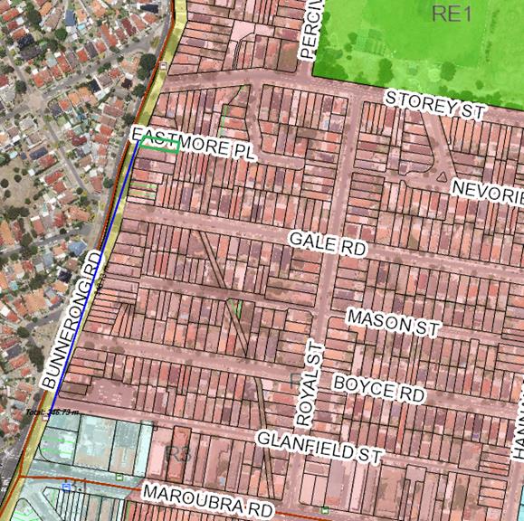
Aerial showing the zones and uses in the surrounding area. Red shading identifies the surrounding area is predominately zoned R2 Low Density Residential, Burgundy line identifies the regular bus route, green shading identifies Snape Park and light blue shading identifies the land zoned B1 Neighbourhood Centre.
The proposed development is configured in one built form fronting Bunnerong Road which is consistent with the siting and layout of other developments in the locality. Bunnerong Road and the surrounding street network contains a mixture of predominately single detached dwelling houses in single and two-storey scales and part three and part four-storey walk up flat buildings of mostly older housing stock (operating as existing use rights under the Environmental Planning and Assessment Act 1979). Along Eastmore Place, the secondary street frontage, single and semi-detached dwellings front the laneway including garages.
To the north, on the opposite corner, identified as No. 211 Bunnerong Road is a part two part three storey dwelling house whose southern elevation faces the subject site. The southern elevation contains mostly service and non-habitable room uses as they rely less on solar access. To the south, the site adjoins a part three part four storey red brick walk up flat building with parking and clothes lines within the rear yard. Street and aerial views are shown below.
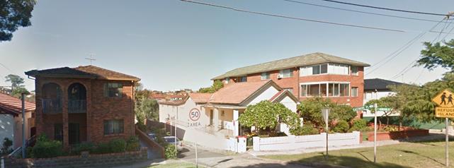
Street view of subject site in centre – 213 Bunnerong Road, at left two storey dwelling at 211 Bunnerong Road) and adjoining to the south is the multi storey flat building at 215 Bunnerong Road).
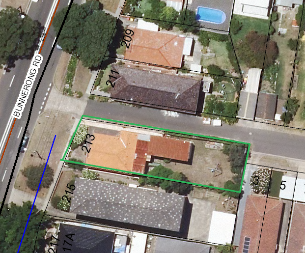
Aerial view of subject site and adjoining development.
Compatibility of built form:
It is considered that the character of the proposal is satisfactory with the existing surrounds and expected future character which is dictated by the RLEP standards for FSR and height standards for the site and surrounding properties co located within the R2 zone. As well, the proposal is also generally considered satisfactory with the existing surrounds and expected future character dictated by the RDCP 2013 controls and objectives in Part C1 relating to low density residential development. In particular, the proposed development has a traditional envelope form for low residential developments that are permitted in the zone and the wider LGA. The upper most level (level 1 is designed as an attic style contained as a habitable roof form within the main roof and the rear contains a two-storey element.
· Floor space ratio
The proposed development has a floor space ratio of 0.47:1 reduced from 0.49:1 as originally sought and readily meets the maximum 0.65:1 standard applicable to the site under the ARHSEPP. The indicated FSR does not include the breezeway which some submissions have indicated should be included as it is predominately enclosed. In this respect, even if the breezeway was included in the FSR the proposed development would have a FSR of around 0.6:1 which as noted earlier is still below the maximum FSR permitted under the ARHSEPP. In terms of compatibility of built form, an assessment of the particular siting and building design elements of the development carried out as follows:
· Overall height and external wall heights
The proposal has an overall height less than the 9.5m maximum height of buildings standard applying to development in the R2 zone under the RLEP. Physically, the proposal is well below the height of the flat building adjoining to the south at No. 215 Bunnerong Road. The proposal also has a wall height that is well below the 8m maximum external wall height control applying to sloping sites under Part C1 of the RDCP. In relation to the predominantly low density built form in the surrounding area the proposed heights of the development are considered to display a high level of compatibility having particular regard to streetscape character and neighbouring developments. The proposed walls are well articulated at the front and along the side elevations compliant with the maximum external wall heights and minimum setback controls for low density residential forms of development and in some instance particularly along the secondary street frontage the proposal provides greater setback than the minimum required under the RDCP.
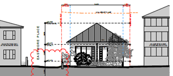
Streetscape view of proposed development and neighbouring development’s at No. 211 Bunnerong Road (shown at left) being a two storey dwelling as viewed from Bunnerong Road and No. 215 Bunnerong Road (shown at right) a three storey flat building as viewed from Bunnerong Road.
· Setbacks
Front setback
The front setback is the average of the two nearest buildings at No. 211 and 215 Bunnerong Road and therefore complies with the provisions under Part C1 of the RDCP.
Side setbacks
The proposal has southern side setbacks of 1200mm and 3700mm for a small stepped in section towards the front and will comply with the minimum 1200mm minimum side setbacks apply to low density residential development under Part C1 of the RDCP. The proposal has a secondary setback of between 1500mm and 2500mm which is readily compliant with the 1500mm minimum required under Part C1 of the RDCP.
Rear setbacks
The site is on a corner which means that under Part C1 of the RDCP no minimum rear setback control applies. Notwithstanding, the applicant was asked to provide clear indication of the shadowing caused to the rear common open space area of the flat building to the south at No. 215 Bunnerong Road with particular regard to the clothes drying area.
The applicant provided shadow diagrams that demonstrated that the north facing ground level apartments will receive solar access between 10am and 3pm during the winter solstice which readily meets the minimum 2hrs required under the Apartment Design Guide and the three hours required for low density residential forms of development under Part C1 of the RDCP. The shadow plans also demonstrate that the clothes drying area at the north eastern corner of the No. 215 Bunnerong Road will also receive solar access between 8am and 12noon. The other parts of the rear yard of the flat building comprise vehicle maneuvering areas which don’t rely on solar access.
Site coverage and landscaped areas
The proposed development has a site coverage of 50% complying with the 50% maximum permitted for low density development on surrounding properties. The proposed development also provides 43% deep soil area on site which is significantly greater than the 30% minimum required for low density forms of development on the surrounding properties.
Overall, the proposed development will sit comfortably within the streetscape along Bunnerong Road and Eastmore Place without any significant or unavoidable amenity impacts on the neighbouring properties. For the purposes of compatibility of built form the proposed development will meet the character test required under Clause 30A of ARSEPP – Affordable Rental Housing and allows an appropriate scale relative to the neighbouring properties and the wider development in the R2 low density residential zone.
Solar access and overshadowing
Whilst the DCP for boarding houses does not contain specific controls in relation to solar access and overshadowing impacts for boarding houses, the objectives and controls from Part C1 Low density residential development provide a suitable guide in this regard:
· To ensure new dwellings and alterations and additions are sited and designed to maximise solar access to the living areas and private open space.
· To ensure development retains reasonable levels of solar access to the neighbouring dwellings and their private open space.
· To provide adequate ambient daylight to dwellings and minimise the need for artificial lighting.
The controls with respect to neighbouring dwellings require that a portion of the north-facing living area windows of neighbouring dwellings must receive a minimum of 3 hours of direct sunlight between 8am and 4pm on 21 June.
The proposed development readily complies with this control as demonstrated in the elevation shadow diagrams below which show a comparison between the existing and proposed shadows from 9am to 2pm showing that the ground level north facing windows will receive solar access for at least five hours during the winter solstice.
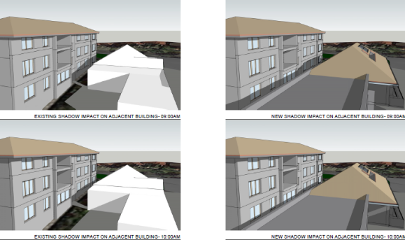
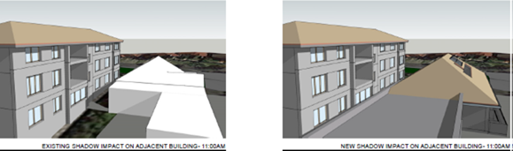
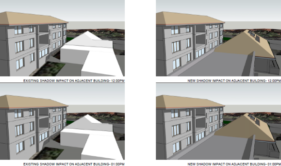
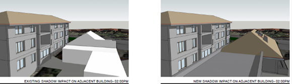
Communal open space and clothes line area
The controls with respect to neighbouring properties private open space require that the private open space of neighbouring dwellings must receive a minimum of 3 hours of direct sunlight between 8am and 4pm on 21 June. The area covered by sunlight must be capable of supporting passive recreation activities.
The proposed development results in additional shadowing to the rear of the property at No. 215 Bunnerong Road containing a clothes line at the top right corner of the site and garden open space along the northern side fence as shown in the aerial below.
The clothes line area at the rear of No. 215 Bunnerong Road will receive at least three hours of solar access between 8am and 12 noon as shown in the two diagrams below.
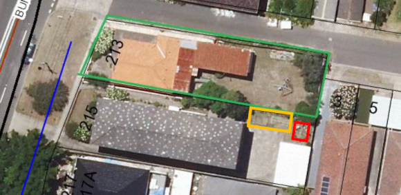
Aerial of subject site and neighbouring property showing the location of open communal space (Orange outline) and clothes line (Red outline) as approved under BA/973/1968.
The submitted shadow diagrams at 9am and 12noon, as shown below, show that the clothes line area will receive three hours of solar access during the winter solstice. In relation to the communal open space of No. 215 Bunnerong Road, the diagrams show that there is a marginal difference between shadowing caused by the existing development, that is the fencing, and the proposed development to this area of communal open space. It is noted that the area south of the communal area is driveway space. The shadowing from the fencing is inevitable as it is a result of the east west orientation of the site.
|
9am shadow |
12 noon shadow |
|
|
|
|
Shadow diagrams: The diagrams above show at the proposed developments overshadwoing impacts on the southern site at No. 215 Bunnerong Road. In particlar, the area bounded by blue box is the location of the neighobur’s clothes line. The shadow diagrams show that this area will receive solar access during the wintter solstice. |
|
The solar access to the neighbouring property as a result of the proposed development are assessed as acceptable in the circumstances.
Overall, the predominant built form in the surrounding area and locality pattern is characterized by single and two storey dwelling houses and residential flat buildings (operating as existing use rights). The proposed development has a built form and height that is comparable to and compatible with the surrounding development.
Compatibility of use:
· Number of lodgers
The proposed use of the site, which comprises boarding house with 11 rooms and a maximum of 14 lodgers (3 double rooms at lower ground level, 6 single rooms at ground level and 1 double room at level 1), constitutes a permissible form of development, and one that is envisaged by the ARHSEPP 2009.
· Visual and acoustic privacy
Having regard to the privacy impacts both visual and acoustic, the proposed development will not result in any significant or unreasonable adverse visual and acoustic impacts on the neighbouring dwellings.
In terms of acoustic privacy, the applicant has submitted an acoustic report to accompany the development application which has been reviewed by Council’s Environmental Health Officer who indicates that the development is acceptable in minimizing noise transmission to the neighbouring dwellings and will comply with the relevant noise criteria. The proposed use is for a residential purpose with self-contained facilities, tenanted for a minimum period of three months which generally means that it isn’t inherently noisy compared to short term accommodation. In addition, the development application is accompanied by a plan of management setting out house rules which in particular restricts common outdoor area use between 9pm and 7am which will minimise the likelihood of sleep disturbance.
In terms of visual privacy, the boarding house is sited and designed such that a reasonable level of visual privacy will be maintained to the neighbouring dwellings. In particular, the corner allotment affords a sizable separation of between 8.7m and 11.4m away from the southern side of the single dwelling at No. 211 Bunnerong Road. The boarding rooms facing north also contain planter boxes which will provide an additional visual privacy buffer. Moreover, a review of the approved dwelling at No. 211 Bunnerong Road shows their windows opposite Eastmore Place, facing the boarding house, are predominately non-habitable rooms including linen, storage, and bathroom uses. There are habitable rooms such as a ground level living room and first floor level living room at the far eastern end of this dwelling, whose privacy is considered to be suitable protected by the physical privacy measures of separation and planters.
Having regard to the visual and acoustic privacy of the development to the south that is the flat building at No. 215 Bunnerong Road, the proposal predominately contains a breezeway which is a transient area, designed with full height screening and not likely to result in any significant adverse visual and acoustic privacy impacts.
Overall, in relation to privacy, the proposed development contains suitable design and operational measures which will ensure acceptable mutual levels of visual and acoustic privacy and will not result in any significant adverse visual or acoustic privacy impacts on the neighbouring properties.
Plan of Management
The RDCP under Part C4 Boarding houses and Part B9 Management Plans sets out the requirement and contents of a Management Plan to be submitted with all DAs for new and existing boarding houses. Management plans are required to address the general requirements outlined in the Management Plan section in Part B, which includes the following matters:
· Selection of residents with preference for people on low and moderate incomes;
· Furnishings;
· House rules, covering issues such as lodger behaviour, visitor and party policies, activities and noise control, use and operation hours of common areas (e.g. communal open space and living rooms) and policies for regulating smoking and consumption of alcohol and illicit drugs;
· Cleaning and vermin control arrangements for shared facilities and
· Public notice and signs
A plan of management and House Rules accompany the application and it is generally considered to suitably address the requirements under Part C4 and Part B9 of the RDCP 2013. Adherence to the management plan and additional matters will be a conditional requirement and serve to ensure the operation of the boarding house will not result in any significant or unreasonable adverse impacts on the amenity of neighbouring properties and the surrounding area.
Overall, the proposal provides affordable housing to the community in a location within close proximity to services, public transport, infrastructure and recreational facilities integrating effectively into the existing and evolving character of the locality. The effective management of the premises is considered to be achievable.
Consistency with the objectives of the Low Density Residential R2 zone;
The proposal is clearly consistent with the objectives of the zone, detailed as follows:
• To provide for the housing needs of the community within a low density residential environment.
The proposed development for a boarding house is permissible in the zone and will provide additional housing needs of the community.
• To recognise the desirable elements of the existing streetscape and built form or, in precincts undergoing transition, that contribute to the desired future character of the area.
As demonstrated throughout the character assessment, the proposed development has a built form that will generally be consistent with the bulk and scale envisaged by the Standards applicable to the R2 zone with particular reference to the specific provisions in Part C1 of the RDCP applying to low density residential forms of development permissible on the site and the surrounding area.
• To protect the amenity of residents.
The amenity of residents having regard to solar access, views, privacy and visual amenity will be suitably protected.
• To encourage housing affordability.
The proposal for a boarding house is a form of affordable housing as defined under the ARHSEPP 2009.
Overall, having regard to the above it is considered that the character test is satisfied on this occasion.
Relationship to City Plan
The relationship with the City Plan is as follows:
Outcome 4: Excellence in urban design and development.
Direction 4a: Improved design and sustainability across all development.
Financial impact statement
There is no direct financial impact for this matter.
Conclusion
The proposal complies with the relevant assessment criteria and where non-compliance occurs with particular provisions there are adequate planning explanations for satisfying the relevant objectives associated with the controls.
The proposed will not result in any adverse impacts upon either the amenity of the adjoining premises or the character of the locality subject to conditions being imposed or compliance with the recommended conditions contained in the attached DA compliance report.
The application is therefore recommended for approval subject to the attached conditions of consent.
|
That Council, as the consent authority, grants development consent under Sections 80 and 80A of the Environmental Planning and Assessment Act 1979, as amended, to Development Application No. DA/237/2017 for retention of portion of structure of existing dwelling and incorporation into construction of 3part two part three storey boarding house containing 11 boarding rooms, communal facilities, parking for 3 cars, motorcycle and bicycle parking, landscaping and associated works. at No. 213 Bunnerong Road, Kingsford, subject to the following non standard conditions and the standard conditions contained in the development application compliance report attached to this report:
Non-standard conditions
Amendment of Plans & Documentation 2. The approved plans and documents must be amended in accordance with the following requirements:
a. All privacy screens shall be designed so that the total area of any openings within the privacy screens must not exceed 25% of the area of the screens.
b. The rear boundary fence located on the eastern boundary shall be installed at a height of 2100mm, measured above the finished ground level within the subject site.
The applicant and owner is advised that the relevant provisions of the Dividing Fences Act 1991 are to be satisfied accordingly and any necessary approvals or agreements should be obtained from the owner/s of the adjoining land beforehand.
c. A Plan of Management Plan governing the use and operation boarding house shall be submitted to Council for approval having regard to (but not limited by) the following aspects of the development:
§ Management of the boarding rooms § Operational details § Amenity § Safety and security § Waste management § Fire safety § Deliveries and loading/unloading § Complaint management § Booking, Reception and access provisions
The plan of management shall be provided to Council’s Manager Development Assessment for approval prior to an occupation certificate being issued. The plan of management shall be reviewed by a qualified acoustic consultant and include relevant recommended acoustic measures by an acoustic expert. Once approved the plan of management shall be complied with at all times subject to conditions of consent.
d. The Landscape plan LA01 Rev A dated 13/04/2017 shall be amended to reflect the amended layout of the development. Additional landscaping shall be provided to the secondary street frontage opposite LG BR.1, LC BR.2 & LG BR.3. The additional landscape shall include trees and plants to provide an additional privacy buffer opposite the dwelling opposite located at No. 211 Bunnerong Road and No. 215 Bunnerong Road. Details shall be submitted to Council’s Landscape Development Officer for approval prior to a Construction Certificate being issued for the development.
|
|
1.⇨ |
DA Compliance Report - 213 Bunnerong Road, MAROUBRA |
Included under separate cover |
Planning Committee 14 November 2017
Development Application Report No. D82/17
Subject: 4-6 Grosvenor Street, Kensington (DA/166/2017)
Folder No: DA/166/2017
Author: Roger Quinton, Coordinator Development Assessment
Proposal: Demolition of existing structures, construction of a 3 storey residential flat building containing 9 dwellings, basement parking for 13 vehicles, landscaping and associated works
Ward: West Ward
Applicant: New Oriental Pty Ltd
Owner: New Oriental Pty Ltd
Summary
Recommendation: Approval
|
|
|
|
Subject Site |
|
|
|
|
|
|
|
|
|
|
|
|
|
|
Submissions received
|
|
|
Ù North
|
|
|
Locality Plan |
Development Application Executive summary report
The proposed development is referred to the Planning Committee as it has a cost of works greater than $2 million.
Proposal
Demolition of existing structures, construction of a three storey residential flat building containing nine dwellings, basement parking for 13 cars, landscaping and associated works.
Amended plans were received on 14 June 2017 which included the following changes:
· Reduction in floor area by 35 sqm, which results in the development having a proposed FSR of 0.939:1, reduced from the 0.99:1 as proposed in the application as originally submitted.
· Reduction in the height of the proposal from 12m to 10.5m.
· Revision of the basement layout and an increase in deep soil landscaping.
· Addition of privacy measures and planting to limit privacy impacts on No. 8 Grosvenor Street.
Site
The area is characterised by single dwellings and residential flat buildings of three and four storeys in height. A primary school is located at the corner of Grosvenor and Kensington Streets. Anzac parade is located approximately 200m to the east.
Adjacent development includes a four storey residential flat building to the west three storey.
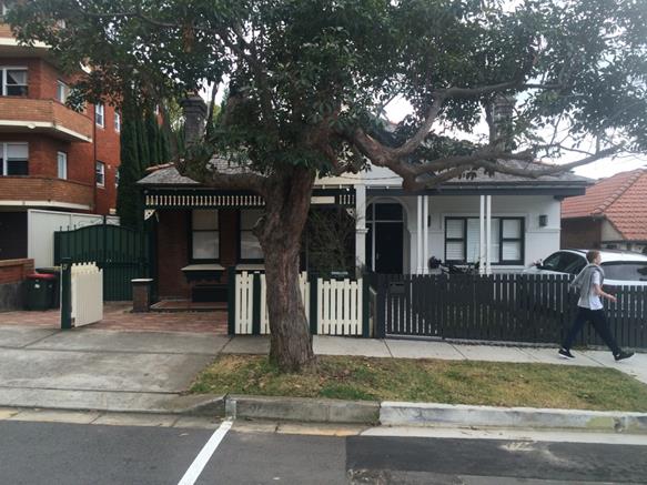
Subject site at No. 4- 6 Grosvenor Street
Randwick Local Environmental Plan 2012
The key standards and objectives in the RLEP 2012 applicable to the development are detailed below:
Key RLEP Standards
|
Description |
Council Standard |
Proposed |
Compliance (Yes/No) |
|
R3 Medium Density |
Objectives |
Listed below under Clause 4.6 exception |
See below |
|
Height of Buildings – Clause 4.3 |
12m |
10.5m |
Yes |
|
Floor Space Ratio – Clause 4.4 |
0.9:1 |
0.93:1 |
No – see Clause 4.6 discussion below |
Land use – R3 Medium Density Residential Zone
The relevant objectives under RLEP 2012 for the medium density zone are as follows:
· To provide for the housing needs of the community within a medium density residential environment
· To provide a variety of housing types within a medium density residential environment
The proposal provides for additional dwellings in a medium density scale which will meet the needs of the community. The proposal provides additional housing choice for residents.
· To recognize the desirable elements in the existing streetscape and built form or, in precincts undergoing transition, that contribute to the desired future character of the area.
· To protect the amenity of residents.
As detailed in this assessment, it is considered that the proposal will be acceptable in regard to potential impacts on neighbours and the area in general. The design of the development is also acceptable and has been reviewed by Council’s Design Excellence Panel. The proposal will be in keeping with the desired future character of the area.
Clause 4.6 - Exceptions to development standards
Clause 4.6 of RLEP provides a mechanism for variation to development standards in certain circumstances.
The proposal contravenes the maximum floor space ratio (FSR) development standard of Clause 4.4: Floor Space Ratio, contained within RLEP 2012. The applicant has submitted a written justification that seeks to justify the contravention of the standard pursuant to Clause 4.6. The variation is addressed as follows:
Clause 4.4 - Floor Space Ratio Control
Clause 4.4 (2) states that the maximum floor space ratio for a building on any land is not to exceed the floor space ratio shown for the land on the Floor Space Ratio Map. The FSR indicated on the map for the land is 0.9:1.
The proposed FSR is 0.93:1 (or GFA of 321.7m²). The proposed variation is summarized in the table below:
|
Site area |
689.8m² |
|
Proposal |
FSR of 0.939:1 |
|
LEP development standard |
0.9:1 |
|
% variation to development standard |
4.3% |
Assessment against the applicant’s written justifications for the contravention of the development standard
Pursuant to clause 4.6(3) of RLEP 2012 development consent must not be granted for development that contravenes a development standard unless the consent authority has considered a written request from the applicant that seeks to justify the contravention of the development standard by demonstrating:
(a) that compliance with the development standard is unreasonable or unnecessary in the circumstances of the case, and
(b) that there are sufficient environmental planning grounds to justify contravening the development standard.
Further, the consent authority must be satisfied that:
(i) the applicant’s written request has adequately addressed the matters required to be demonstrated by subclause (3), and
(ii) the proposed development will be in the public interest because it is consistent with the objectives of the particular standard and the objectives for development within the zone in which the development is proposed to be carried out, and
The concurrence of the Director-General of the Department of Planning and Infrastructure must also be obtained for development that contravenes a development standard. However, pursuant to the Notification of assumed concurrence of the Director-General under clause 4.6(4) (and the former clause 24(4)) of the Standard Instrument contained in Planning Circular PS 08–003 (dated 9 May 2008) the concurrence of the Director-General of the Department of Planning and Infrastructure under clause 4.6(4)(b) of RLEP 2012 may be assumed in certain cases.
In relation to the matters required to be demonstrated by subclause (3) there are various ways that may be invoked to establish that compliance with a development standard is unreasonable or unnecessary as discussed by Chief Justice Preston of the NSW Land and Environment Court in the case of in Wehbe v Pittwater Council [2007] NSWLEC 827. Although the Wehbe case was decided in relation to State Environmental Planning Policy No 1—Development Standards (“SEPP 1”) and not clause 4.6 of RLEP 2012 it remains of some assistance in relation to identifying the ways in which an applicant may demonstrate that compliance with a development standard is unreasonable or unnecessary in the circumstances of the case.
Has the applicant’s written request adequately addressed that compliance with the development standard is unreasonable or unnecessary in the circumstances of the case?
In the Wehbe case Justice Preston said the most commonly invoked way to establish that compliance with a development standard is unreasonable or unnecessary is to demonstrate that the objectives of the development standard are achieved notwithstanding non-compliance with the standard.
The objectives of the floor space ratio standard are set out in clause 4.4(1) of RLEP 2012 as follows:
(a) to ensure that the size and scale of development is compatible with the desired future character of the locality,
(b) to ensure that buildings are well articulated and respond to environmental and energy needs,
(c) to ensure that development is compatible with the scale and character of contributory buildings in a conservation area or near a heritage item,
(d) to ensure that development does not adversely impact on the amenity of adjoining and neighbouring land in terms of visual bulk, loss of privacy, overshadowing and views.
The applicant’s written justifications outline the following key arguments for the departure from the standard:
Clause 4.6(3)(a) - Is Compliance with the development standard unreasonable or unnecessary in the circumstances of the case
When considering the amended design, we are of the opinion that enforced compliance with the FSR standard is unreasonable and unnecessary given the circumstances of this case. Many of the below points were provided in Mecone’s original Clause 4.6 assessment and remain relevant again:
· The proposal is consistent with the objectives of the standard as outlined below in this report (Wehbe “Test 1”).
· Additional FSR is distributed evenly throughout the building and does not result in any obvious elements of extra bulk, nor does it cause the building height standard to be exceeded. This is particularly more evident given the deletion of the upper level mezannine.
· The locality consists of varied built forms, in particular noting 4 storey developments to the west and north. These buildings appear significantly bulkier than the proposed development at 4-6 Grosvenor Street. Strict compliance with the FSR standard would be unreasonable in the circumstances, as this would not result in the proposed building being any more compatible with the surrounding area than it already would be. The non-compliance does not result in a proposal which is out of character with the surrounding built form;
· The original proposal was reviewed by Council’s Design Review Panel (DRP) who advised that additional FSR would be of little consequence. This determination would remain for the revised scheme, which proposes even less of a variation to the control;
· The development has been revised to ensure compliance against key RDCP 2013 controls of concern to Council, namely: Solar access and overshadowing; Deep Soil Zones and Privacy.
The proposal also remains consistent with RDCP 2013 controls for building envelope, setbacks, and massing. This demonstrates that the built form, which is controlled in part by FSR, is reasonable and acceptable;
· The proposed development, as amended, remains consistent with the objectives of the FSR standard as outlined previously by Mecone and again within this document. The key objectives of the FSR standard primarily relates to controlling bulk, scale, adverse impacts, and ensuring appropriate design. The request for variation needs to be considered against these overarching objectives, and the revised design clearly complies with the objectives of the standard, despite the variation;
· The proposed development is consistent with the objectives of development in the R3 Medium Density Residential Zone, as outlined previously by Mecone and again further in this document;
· The contravention of the FSR standard does not raise any matter of State or regional planning significance; and
· There is no public benefit in maintaining the standard in the circumstances of the case as explained below.
Following from the above, our position remains that there is no benefit in strictly enforcing an FSR-compliant scheme, particularly given the very minor encroachment that is proposed (only 27sqm or 4.3%), and the indiscernible physical change which would come from compliance. For these reasons, compliance with the development standard is still considered unreasonable and unnecessary.
Clause 4.6(3)(b) - Are there sufficient environmental planning grounds to justify contravening the development standard?
There are sufficient environmental planning grounds for the contravention to the FSR standard as follows:
· The Land and Environment Court in its recent decisions in Four2Five vs Ashfield Council has ruled that a clause 4.6 variation must do more than demonstrate that the development meets the objectives of the development standard and the zone, a test commonly referred to as the Wehbe Test #1 (which are matters dealt with further below). The clause 4.6 objection must also demonstrate some other environmental planning grounds that justify contravening the development standard, preferably some that are specific to the site, although that is not essential, according to the Court of Appeal decision in Four2Five vs Ashfield Council. The decision also suggests that the requirements under clause 4.6(3)(a) and (b) must not be ‘watered down’ and must be adequately addressed.
· The proposed built form has been amended to present as a 3 storey building, with no mezzanine level, which fits easily into the 12m height limit. This amended design is suitable for the site and consistent with the scale of the existing and new development and is, in fact, less dominant than many existing nearby buildings which feature a fourth storey.
· This presents environmental planning grounds to justify the encroachment given that the breach in FSR, which controls building form, does not present any built form incompatibility issues.
· The site of the proposed development is constrained in size, at less than 700m2, making it a challenge to provide a development which strictly complies with all controls, and still provides excellent amenity for existing and future residents. The proposal has managed to do this, incorporating a minor increase in floor area.
· Additional FSR has no environmental impact. In terms of visual appearance, the additional density is evenly distributed throughout the building rather than resulting in an obvious additional floor or encroachment above the height or setback requirements. Environmental impacts of the development as a whole are mitigated through engineering solutions for stormwater matters, articulation in façade and building height compliance for overshadowing. The remaining additional FSR does not impede on these outcomes or otherwise substantially increase the impacts.
· The remaining additional FSR and a more efficient building redesign still provides a better typology mix without an increase in apartment numbers. As outlined previously to Council, the development increases the number of 3 bedroom dwellings provided in comparison to the almost identical development at 8-10 Grosvenor Street, despite no increase in the overall provision of 9 units. Greater housing mix is a significantly better planning outcome as this promotes further diversity in Kensington, allowing larger family groups to reside at the property.
· Given the above strict compliance with the FSR control would hinder the attainment of the objects of the Act, and would not result in the orderly and economic use and development of land.
· Council raised specific concerns with the proposed development in letter dated 15 May 2017. The revision to the design and subsequent reduction in FSR has addressed the issues that Council raised.
Clause 4.6(4)(a)(ii) - Is the proposed development in the public interest because it is consistent with the objectives of the particular standard and the objectives for development within the zone in which the development is proposed to be carried out
In the court case Four2Five Pty Ltd v Ashfield Council [2015] NSWLEC 90, Commissioner Pearson stipulates that the consent authority is to be satisfied the proposed development will be in the public interest because it is consistent with:
a) the objectives of the particular standard, and
b) the objectives for development within the zone in which the development is proposed to be carried out.
The objectives of the development standard and the zone are addressed below under the relevant headings:
(i) the objectives of the particular standard
The particular development standard is Clause 4.4 FSR of the RLEP and the relevant objectives are addressed below:
(a) to ensure that the size and scale of development is compatible with the desired future character of the locality
The size and scale of the proposed residential flat building is compatible with the desired future character of the locality, referred to within the zoning objectives. The building presents as a three storey building to Grosvenor Street which aligns with development to its sides and rear, and does not dominate the single storey dwellings on the opposite side of the street.
(b) to ensure that buildings are well articulated and respond to environmental and energy needs,
The building has been well designed with good articulation, variation in materiality, and a response to environmental and energy needs. This is evidenced by the proposal’s exceedance of minimum cross ventilation, solar access, and BASIX requirements.
(c) to ensure that development is compatible with the scale and character of contributory buildings in a conservation area or near a heritage item,
The proposal is not within a heritage conservation area and does not adjoin any heritage items.
(d) to ensure that development does not adversely impact on the amenity of adjoining and neighbouring land in terms of visual bulk, loss of privacy, overshadowing and views.
The proposal does not adversely impact on the amenity of adjoining and neighbouring land in terms of the above items. The site is orientated north-south, and as such shadows that are cast move quickly from the property to the west in the morning, to Grosvenor Street to the south, and to the property to the east in the afternoon. The proposal has been well designed to ensure visual privacy is retained for all surrounding properties, through high level windows on side boundaries, and elements of privacy screening on balconies.
The visual bulk of the development is consistent with surrounding development in the R3 Zone, which consists of many 3-4 storey apartment buildings.
(ii) the objectives for development within the zone in which the development is proposed to be carried out.
The objectives of the R3 Medium Density Residential zone are as follows:
· To provide for the housing needs of the community within a medium density residential environment.
The development provides additional housing for the needs of the community in an area consisting of a number of medium density residential properties.
· To provide a variety of housing types within a medium density residential environment.
The proposal will provide a range of unit types within a medium density residential environment. This will include 1 x beds, 2 x beds, and 3 x bed apartments, to cater for the needs of individuals, couples, groups, and families.
· To enable other land uses that provide facilities or services to meet the day to day needs of residents.
The proposal does not impact upon the ability of other land in the zone being able to provide for different facilities or services.
· To recognise the desirable elements of the existing streetscape and built form or, in precincts undergoing transition, that contribute to the desired future character of the area.
Desirable elements of the existing streetscape, such as consistent setbacks, landscaped areas, street trees, and development between 1 to 3 or 4 storeys, is respected by the development.
· To protect the amenity of residents.
The proposal is designed in accordance with Council regulations around setbacks, building height, design, overshadowing, privacy, parking, and building materiality. The proposal is considered to therefore protect the amenity of residents.
· To encourage housing affordability.
The proposal replaces two existing dwellings with 9 total dwellings. These 9 dwellings are each likely to be purchased at a price far below that of which the existing dwellings are worth, opening up the suburb for a number of additional prospective purchasers. This encourages housing affordability in the Randwick LGA and places downward pressure on the cost of housing.
Assessing officer’s comment:
In assessing the proposed variation against the objectives of FSR standard, it is considered that the development achieves consistency with the objectives and will provide a positive planning outcome.
Despite the proposal exceeding the relevant development standard, the proposed floor space of the development is considered to be generally acceptable for the following reasons:
· The proposed development has been amended during the assessment process, significantly reducing the proposed floor area and reducing the height of the development to well within the height standard. The variation is now reduced to be a relatively small variation from the standard of 4.3%. The additional floor area does not result in any perceivable additional bulk with the floor area of the development being evenly distributed.
· The proposal generally complies with relevant building envelope controls contained within Randwick Development Control 2013, including setbacks and deep soil landscaping. The proposed development also meets the height development standard contained in the Randwick Local Environmental Plan 2012 and will be consistent with the desired future character anticipated by Council’s built form controls.
· Solar impacts on adjacent sites are generally acceptable and are not directly the result of additional floor space as detailed in this assessment.
· The proposed development meets the relevant Zone Objectives and provides a reasonable form of medium density residential development.
Specifically in relation to the relevant objectives of the floor space ratio development standard the variation is considered to be acceptable because:
· The proposed development is compatible with the size and scale of the desired future character of the locality as the building envelope controls of maximum height, wall height and setbacks are generally satisfied. The proposed development will match the scale of the residential flat building being constructed at 8-10 Grosvenor Street.
· The proposed building is well articulated, with a break in the length of the building so that the bulk reads as two building forms when viewed from the east and west. The street elevation includes a variety of building materials and the proposed balconies break up the façade and reduce the perception of building bulk.
· The impact of the development on the heritage item at no. 16 Grosvenor Street and the Sacred Heart Heritage Conservation Area is considered to be acceptable. The contemporary form of the development will distinguish between the old and the new buildings in the streetscape and the bulk and the scale of the proposal is such that it will not detract from the significance of the heritage item or the conservation area. The proposal will meet the objectives of Clause 5.10: Heritage Conservation contained within RLEP2012.
· The impact of the development on the amenity of adjacent properties is considered to be acceptable, as discussed in this assessment, in particular, shading of No. 2 Grosvenor Street is not considered to be the result of any additional proposed building bulk adjacent to that property.
In conclusion, the applicant’s written request has successfully demonstrated that compliance with the development standard in question is unreasonable or unnecessary in the circumstances of the case.
Has the applicant’s written request adequately addressed that there are sufficient environmental planning grounds to justify contravening the development standard?
The proposal has been carefully designed to achieve the planning objectives for the locality and to fit in with the scale and character of existing and proposed development in the immediate context, whilst minimising potential adverse impacts on surrounding properties.
The applicant’s written request has successfully demonstrated that there are sufficient environmental planning grounds to justify contravening the development standard.
Will the proposed development be in the public interest because it is consistent with the objectives of the particular standard and the objectives for development within the zone in which the development is proposed to be carried out?
Based on the above assessment, it is considered that the proposed development is consistent with the objectives of the Floor Space Ratio standard. The relevant objectives for development within the zone in which the development is proposed to be carried out (Zone R3 – Medium Density Residential) are:
· To provide for the housing needs of the community within a medium density residential environment
· To provide a variety of housing types within a medium density residential environment
· To recognize the desirable elements in the existing streetscape and built form or, in precincts undergoing transition, that contribute to the desired future character of the area.
· To protect the amenity of residents.
Subject to conditions, it is considered that the proposed development is consistent with the objectives that are relevant because it is sympathetic to the existing residential environment and built form and would not have an unacceptable impact on the amenity of residents.
· The proposed development is considered to be in the public interest because it is consistent with the objectives of the standard and the relevant objectives for development within Zone R3 - Medium Density Residential.
Does the Council have delegation to exercise the concurrence function of the Director-General of the Department of Planning and Infrastructure for development that contravenes a development standard? If so:
(a) whether contravention of the development standard raises any matter of significance for State or regional environmental planning, and
(b) the public benefit of maintaining the development standard.
Comments:
Pursuant to the Notification of assumed concurrence of the Director-General under clause 4.6(4) (and the former clause 24(4)) of the Standard Instrument contained in Planning Circular PS 08–003 (dated 9 May 2008) the concurrence of the Director-General of the Department of Planning and Infrastructure under clause 4.6(4)(b) of RLEP 2012 may be assumed to the granting of development consent to the development that contravenes the development standard for Floor Space Ratio in clause 4.4 of RLEP 2012.
Variation from the adherence to the numerical Floor Space Ratio standard will not be detrimental to the orderly use of the site and there is no public benefit in maintaining the development standard in this instance.
The proposed development and variation from the development standard does not raise any matters of significance for State or regional environmental planning. The strict adherence to the numerical standard will not be necessary, in this case, for maintaining the low density housing forms, where such development does not compromise the amenity of surrounding residential areas and is compatible with the dominant character of existing development.
Submissions
The owners of adjoining and likely affected neighbouring properties were notified of the proposed development in accordance with the Randwick Comprehensive DCP 2013. The following submission was received as a result of the notification process:
· 2 Grosvenor Street (unit unspecified)
A late submission was also received from:
· Unit 3, 2 Grosvenor Street
Issue:
· The proposal will have a negative impact on the privacy and ventilation of the residential flat building located to the west of the subject property.
Comment: Window openings on the side elevations of the development are either of a highlight style, will be screened or have the minimum separations from windows in adjacent properties as specified in the Apartment Design Guide. Proposed conditions require screening to sides of balconies to limit impacts in this regard. It is not considered that the development will significantly impact on ventilation of adjacent properties given general compliance with required setbacks from boundaries.
· The proposal will negatively impact on views to the east from No. 2 Grosvenor Street.
Comment: The proposed development will not result in significant view loss impacts. Any views lost are not considered to be of significant scenic elements or recognised icons such as city skylines, landmark buildings or natural features of particular note.
· The proposal will cause parking problems in the street.
Comment: The development has been assessed by Council’s Development Engineer as being acceptable and it complies with the car parking requirements in the Randwick Development control Plan 2013.
· The proposal will have a negative impact on solar access to units in No. 2 Grosvenor Street which will also result in additional financial costs due increased electricity use because reduction in natural light.
Comment: See discussion in Key Issues.
· The proposed development will have a negative impact on property values
Comment: This is not a valid matter of consideration under Section 79(c) of the Environmental Planning and Assessment Act, 1979.
· The proposal will negatively impact on the adjacent Heritage Conservation Area
· Comment: As detailed above, the impact of the development on the heritage item at no. 16 Grosvenor Street and the Sacred Heart Heritage Conservation Area is considered to be acceptable. The contemporary form of the development will distinguish between the old and the new buildings in the streetscape and the bulk and the scale of the proposal is such that it will not detract from the significance of the heritage item or the conservation area. The proposal will meet the objectives of Clause 5.10: Heritage Conservation contained within RLEP2012.
Key Issues
Solar access to adjacent properties and minimum building separation requirements
The development will provide a reasonable level of solar access to adjacent development in midwinter, 21 June. There will be additional shading to the first floor east-facing windows of No. 2 Grosvenor Street in the morning on 21 June, however these windows will be clear of the additional shadow by 10am. Of note, however are the two the first floor east-facing windows closest to the street boundary which will lose the only morning solar access received to these windows with the additional shadows received to 9am and there would also be additional shading of the adjacent balcony.
The SEPP 65 Apartment Design Guide (ADG) states that where a neighbouring property does not currently receive a minimum of 2 hours direct solar access between 9am and 3pm in midwinter to living areas, private open space and communal open space the proposed development should not reduce this further by more than 20%. As the proposed development will result in one dwelling within No. 2 Grosvenor Street not gaining any solar access on 21 June there will be an 11% reduction in compliance with the ADG solar access requirements for neighbouring properties. It is noted that the ADG has a 6m separation control (Part 3F – Visual Privacy) between habitable rooms in buildings on adjacent sites. While the proposed development is located 3.3m from the common boundary with No. 2 Grosvenor Street for the portion of the development which is adjacent to the affected units in No. 2 Grosvenor Street, the existing residential flat building at 2 Grosvenor Street is less than 3m from the common boundary, therefore the 6m separation control is not met. The ADG acknowledges that compliance with the separation control is difficult to achieve in relation to narrow allotments in suburban areas that contain older flat buildings; these circumstances apply to the subject site and the surrounding area. In this respect, requiring compliance with the 6m minimum separation control would preclude the permissible and proper development of the site for the purposes of medium density housing.
It is considered that the additional impacts detailed above are acceptable as the proposed development complies with relevant height and exceeds Council’s set back DCP controls in relation to this adjacent property (for the southern-most portion of the proposed development) contained within the RDCP 2013. In addition, the variation to the floor space ratio control is relatively minor and a reduction in floor space to ensure full compliance with the control would not necessarily reduce impacts on No. 2 Grosvenor Street. The location of the residential flat building at No. 2 Grosvenor Street is such that it would be difficult to undertake any reasonable development on the subject site without there being some additional shading on the adjacent property.
There will be no additional shadow impacts on No 2 Grosvenor Street resulting from the proposal after 10am on 21 June.
Privacy Impacts on Adjacent Sites
Window openings on the side elevations of the development are either of a highlight style, will be screened or have the minimum separations from windows in adjacent properties as specified in the Apartment Design Guide. Proposed conditions require screening to sides of balconies to limit privacy impacts ion adjacent properties and detail a minimum sill height for the windows in side elevations which have been identified as highlight windows on the plans submitted with the application.
Relationship to City Plan
The relationship with the City Plan is as follows:
Outcome 4: Excellence in urban design and development.
Direction 4a: Improved design and sustainability across all development.
Financial impact statement
There is no direct financial impact for this matter.
Conclusion
The proposed development has been assessed against the relevant standards contained within Randwick Local Environmental Plan 2012 and controls contained within Randwick DCP 2013 and considered to be acceptable. Impacts on adjacent properties are considered to be acceptable subject to proposed conditions of consent.
|
A. That Council supports the exceptions to development standards under Clause 4.6 of Randwick Local Environmental Plan 2012 in respect to non-compliance with Clause 4.4 of Randwick Local Environmental Plan 2012, relating to floor space ratio, on the grounds that the proposed development complies with the objectives of the above clause, and will not adversely affect the amenity of the locality, and that the Department of Planning & Environment be advised accordingly.
B. That Council, as the consent authority, grants development consent under Sections 80 and 80A of the Environmental Planning and Assessment Act 1979, as amended, to Development Application No. DA/166/2017 for demolition of existing structures, construction of a 3 storey residential flat building containing 9 dwellings, basement car parking for 13 cars, landscaping and associated works at No.s 4-6 Grosvenor Street, Kensington, subject to the following non standard conditions and the standard conditions contained in the development application compliance report attached to this report:
Non standard conditions Amendment of Plans 2. The approved plans and documents must be amended in accordance with the following requirements:
a. All windows indicated as being highlight windows on the eastern and western elevations must have a minimum sill height of 1.6m above floor level.
b. Privacy screens having a height of 1.6 metres above floor level must be provided to the eastern and western sides of all front and rear balconies. The privacy screens must be constructed of metal or timber and the total area of any openings within the privacy screen must not exceed 25% of the area of the screen. Alternatively, the privacy screen may be constructed with translucent, obscured, frosted or sandblasted glazing in a suitable frame.
|
|
1.⇨ |
DA Compliance Report - 4-6 Grosvenor Street, KENSINGTON |
Included under separate cover |
Planning Committee 14 November 2017
Development Application Report No. D83/17
Subject: 31 Holmes Street, Maroubra (DA/318/2015/A)
Folder No: DA/318/2015/A
Author: Jonathan Blackmore, Environmental Planning Officer
Proposal: Section 96 modification to site the addition 2.4m forward and increase size of first floor, change window size and position and alter roofline.
Original consent: Alterations and new first floor addition to the existing dwelling house including rear ground floor pergola structure.
Ward: East Ward
Applicant: Addit Home Improvements
Owner: Mr M J Mealing & Mrs A M Mealing
Summary
Recommendation: Refusal
|
|
|
|
Subject Site |
|
|
|
|
|
|
|
|
|
|
|
|
|
|
Submissions received
|
|
|
Ù North
|
|
|
Locality Plan |
Development Application Executive Summary Report
The application is referred to the Planning Committee for determination at the request of Councillors D'Souza, Stavrinos and Seng.
Proposal
The applicant proposes a Section 96 modification to site a first floor addition 2.4m forward and increase size of first floor, change window size and position and alter the roofline.
Original consent: Alterations and new first floor addition to the existing dwelling house including rear ground floor pergola structure.
Relevant Application History
The currently proposed siting of the first floor level is comparable to what was originally proposed within the original DA (ref: DA/318/2015). The design of first floor level was changed to that approved after the original assessing officer raised concerns about the prominence and positioning of the first floor level forward of the main ridgeline.
Site
The subject site is located on the southern side of Holmes Street close to its intersection with Garden Street. The surrounding area contains a variety of low density residential development with 1-to-2 storey semi-detached dwellings being a prominent feature. The subject site is rectangular-shaped and generally flat. The site contains a single storey semi-detached dwelling that forms part of a symmetrical pair of dwellings.
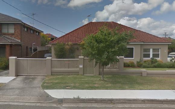
Figure 1. Photograph of the frontage of the subject site.
Section 96 Assessment:
Under the provisions of Section 96 of the Environmental Planning and Assessment Act, 1979, as amended, Council may only agree to a modification of an existing Development Consent if the following criteria has been complied with:-
Substantially the Same Development:
The modification to the approved development does not alter the nature of the approved development as it still maintains the essence of the original consent for a first floor addition. The change in the massing of the upper level may be considered for the purposes of Section 96 of the Environmental Planning and Assessment Act 1979, to remain substantially within the scope of the original development approval both qualitatively and quantitatively.
Submissions
The owners of adjoining and likely affected neighbouring properties were notified of the proposed development in accordance with the DCP – Public Notification. As a result of this notification, no submissions were received.
Section 79c Assessment
Environmental Planning Instruments
State Environment Planning Policy (Building Sustainability Index: BASIX) 2004.
A BASIX assessment is a mandatory component of the development approval process under the Environmental Planning and Assessment Amendment (Building Sustainability Index: BASIX) Regulation 2004 and State Environmental Planning Policy (Building Sustainability Index: BASIX) 2004.
Clause 55A of the EP & A Regulation requires that a new BASIX certificate be lodged for amended plans or where a section 96 modification makes a material change to the BASIX commitments as originally approved.
The applicant has submitted a new BASIX certificate. Standard conditions of consent requiring the continued compliance of the development with the SEPP:BASIX were included in the original determination.
Randwick Local Environmental Plan 2012
The following clauses of LEP 2012 are relevant to the proposed development:
Zone R2 – Low Density Residential
The site is zoned Low Density Residential R2 under the RLEP 2012 and the proposal is permissible with Council's consent. The proposed modification is inconsistent with the aims of RLEP 2012 and the specific objectives of the zone in that the proposal will not preserve the amenity of the surrounding environment. The positioning of the addition is incompatible with the existing and desired future character of the locality.
Maximum Height – Clause 4.3 of the RLEP 2012
The proposed modification does increase the height of the proposal.
Floor Space Ratio – Clause 4.4 of the RLEP 2012
The subject site is less than 300m2 and therefore has no maximum floor space ratio (clause 4.6). A revised FSR of 0.54:1 is proposed, where 0.47:1 was approved.
Development Control Plan
The following sections of the C1 Low Density Residential Section of the RDCP 2013 are considered relevant to the proposed modification.
Provisions for Semi-Detached Dwellings – Sub-Section 4.2
The proposed involves additions and alterations to a symmetrical semi-detached dwelling. The RDCP 2012 requires the bulk of any first floor addition to be setback from the principal street frontage and accommodated to the rear of the dwelling with additions positioned behind the apex or ridge of the main roof and retain any existing gable features and chimneys. The proposed modification involves moving the first floor addition forward on the dwelling by 2.4m to a position forward of the ridge of the main roof.
The proposed non-compliance will be inconsistent with the relevant objectives of the RDCP 2013 and will result in significant adverse impacts in terms of streetscape character. The proposed addition will destroy the symmetry of the pair of semi-detached dwellings and dictate the positioning of any first floor addition to the adjoining semi.
The applicant has argued that there is an established character of first floor additions to semis forward of the ridgeline of the main roof, including on the neighbouring semi at No. 33 and No. 35 Holmes Street and on nearby Edgar Street and that therefore they should be able to do the same. In regards to the first floors of No. 33 and No. 35 Holmes Street, it is noted that these were constructed at the same time and developed as a coherent entity, it is further noted that this development was undertaken under a different RDCP with less restrictions relating to the development of semis. There are no other examples of first floor additions so far forward on a semi within this section of Holmes Street. Examples on other streets within the wider area, including those on Edgar Street, cannot be relied upon as they do not form part of the context of the subject site and within its visual catchment.
Approval of the proposed modification would set an undesirable precedent for future development of the significant number of semi-detached dwellings along Holmes Street. Sites along Holmes street have been already been developed with first floor levels set behind the main ridgeline and the applicant has been able to design an adequate first floor addition behind the main ridgeline as per the current approval.
Other Environmental Impacts – Section 79C(1)(b)
The proposed modification will result in no significant adverse social or economic impacts. However, the proposal will result in significant adverse environmental impacts in terms of the character of the streetscape (as detailed within assessment above).
Site Suitability
The modification to the approved development does not alter the nature or scale of the approved development in relation to site suitability.
Relationship to City Plan
The relationship with the City Plan is as follows:
Outcome 4: Excellence in urban design and development.
Direction 4a: Improved design and sustainability across all development.
Financial Impact Statement
There is no direct financial impact for this matter.
Conclusion
The proposal does not comply with the relevant assessment criteria and will result in adverse impacts upon the character of the locality and set an undesirable precedent.
The application is, therefore, recommended for refusal for the reasons listed under the recommendation below.
|
That Council, as the consent authority, refuse its consent under Section 96 of the Environmental Planning and Assessment Act 1979 as amended to modify Development Consent No. 316/2005 for permission to site the addition 2.4m forward and increase size of first floor, change window size and position and alter roofline at 31 Holmes Street, Maroubra for the following reasons:
1. The proposed development is inconsistent with the objectives of the R2 zone under the RLEP 2012 in that it will not protect the amenity values of the area. The positioning of the addition is incompatible with the existing and desired future character of the locality.
2. The proposal will result in significant adverse impacts in terms of the character of the area and is inconsistent with the objectives under Section 4.2 of the Low Density Residential Section of the Randwick Comprehensive Development Control Plan 2013 as the proposed addition will detract from the symmetry of the pair of semi-detached dwellings and set an undesirable precedent for future development of the significant number of semi-detached dwellings along Holmes Street.
|
Nil
Planning Committee 14 November 2017
Development Application Report No. D84/17
Subject: 10 Seaside Parade, South Coogee (DA/54/2017)
Folder No: DA/54/2017
Author: Perry Head, Environmental Planning Officer
Proposal: Increase height of fence to southern side boundary
Ward: East Ward
Applicant: K Katris
Owner: E Kalogerakis
Summary
Recommendation: Approval
|
|
|
|
Subject Site |
|
|
|
|
|
|
|
|
|
|
|
|
|
|
Submissions received
|
|
|
Ù North
|
|
|
Locality Plan |
Development Application Executive summary report
The application is referred to the Planning Committee for determination at the request of Councillors Shurey, Matson and Bowen.
Proposal
The application details the raising of the height of the fence to the southern side boundary to a maximum of between 1700mm and 1800mm. The height of the fence from the adjoining property at 12 Seaside Parade will vary from 2.4m at the rear corner, 3.2m from the lower level of the private open space and 2.6m to the side passage to the north of that dwelling. The plans as originally submitted sought to raise the fence higher than now proposed, however upon advice from Council that the proposed height would be excessive from the adjoining property the proposal has been amended.
Site
The subject site is on the south western corner of Seaside Parade and Edgecliffe Avenue and contains a two storey dwelling with swimming pool. The site has a frontage to Seaside Parade of 14m a depth of 37m and site area of 495m². The locality is residential and contains a mixture of single and two storey free standing dwellings.
Submissions
The owners of adjoining and likely affected neighbouring properties were notified of the proposed development in accordance with the Randwick Comprehensive DCP 2013. The following submissions were received as a result of the notification process:
|
Issue |
Comment |
|
9 Seaside Parade South Coogee
-The height of the fence is unreasonable and will set an undesirable precedent.
-Other adjoining neighbours may have issues in relation to view loss and loss of privacy.
-There are other measures that could be implemented to improve privacy.
12 Seaside Parade South Coogee
-The height of the proposed fence will be excessive and will be like living in a gaol, with heights in part up to 3.35m.
-There are no other walls of a similar height in the locality.
-As the area is already very built up there is already a degree of overlooking into each other’s properties anyway.
|
The variation to the side fencing has no impact upon views or privacy from any adjoining properties.
Noted, however Council must assess the development application as submitted.
The overall height of the fence has been reduced to an acceptable height.
Noted.
Noted, an inspection of the subject site and the adjoining objector’s site has determined that due to the topography of the locality it is already possible to overlook to varying degrees each other’s properties. |
Key Issues
Side boundary fence
Part 7 of the RDCP details objectives for fencing and ancillary development which include that;
a) The alignment, configuration, rhythm of bays, height, materials, colours and texture of new fences complement the building on the site and the streetscape,
b) Provide for ancillary development that enhances the liveability of dwellings and maintains reasonable levels of visual amenity, solar access and privacy for the neighbouring dwellings.
The controls in relation to side and rear fencing state;
a) The maximum height of site, rear or common boundary fences is limited to 1800mm, as measured from the ground level (existing). For sloping sites, the fence must be stepped to follow the topography of the land with each step not exceeding 2200mm above ground level (existing),
b) In the scenario where there is a significant level difference between the subject and adjoining allotments the fencing height will be considered on merit,
c) The side fence must be tapered down to match the height of the front fence once past the front façade alignment, and
d) Side or common boundary fences must be finished or treated on both sides.
The proposal as originally lodged sought to raise the height of the side fence along the southern side boundary up to 1225mm at the front of the dwelling, between 2535mm and 2955mm along the side passage and up to 2100mm at the rear side boundary.
The amended plans have retained the existing height of the fence at the front portion, lowered the height to 1700mm along the side passage and 1800mm to the rear side boundary. It is noted that there is an existing timber screen which is directly opposite the side entry of the dwelling also is now not to be altered.
The main issue in the consideration of this application is the impact upon the amenity of the adjoining residents due to the height of the fence which arises primarily because of the differing land levels to the sites. The property at No.12 Seaside Parade is at a lower level and consequently the height of the side wall from their property is higher than from the subject property.
The reasonable expectation of the owners of this property to maintain privacy to their dwelling and side passage must be weighed against the also reasonable expectation that any increased height to the existing side fencing not result in an unreasonable loss of amenity to the adjoining residents.
The proposal as originally submitted proposed an increase in height of up to 610mm to the rear section of the fence which is directly opposite the private open space and swimming pool area of No.12. At the highest point the wall would have been up to 4.2m above the lower rear yard area of No.12.
The amended plans have reduced the increased height of the fence at the maximum point as measured from the adjoining property by 1000mm, which is at the lower level of the private open space directly in front of the swimming pool at No.12. The height of the wall at that point will now be 3.2m.
This portion of the fence has the most impact upon the amenity of the adjoining property as it adjoins the lower level of the private open space in front of the swimming pool enclosure. The use of timber screening to increase the overall height of the fence will also reduce the visual impact upon the adjoining property.
On balance, it is considered that the plans as amended by will provide for a reasonable level of additional privacy to the subject property and not result in a significant or unreasonable adverse impact upon the amenity of the adjoining property.
Relationship to City Plan
The relationship with the City Plan is as follows:
Outcome 4: Excellence in urban design and development.
Direction 4a: Improved design and sustainability across all development.
Financial impact statement
There is no direct financial impact for this matter.
Conclusion
That the application to increase the height of the fence to the southern side boundary be approved.
|
That Council, as the consent authority, grants development consent under Sections 80 and 80A of the Environmental Planning and Assessment Act 1979, as amended, to Development Application No. 54/2017 to increase the height of the southern side boundary fence at 10 Seaside Parade South Coogee subject to the standard conditions contained in the development application compliance report.
|
|
1.⇨ |
DA Compliance Report - 10 Seaside Parade, SOUTH COOGEE |
Included under separate cover |
Planning Committee 14 November 2017
Development Application Report No. D85/17
Subject: 2/97-99 Albion Street, Randwick (DA/344/2017)
Folder No: DA/344/2017
Author: Perry Head, Environmental Planning Officer
Proposal: Alterations and additions to existing apartment
Ward: North Ward
Applicant: Thomas Isaksson
Owner: R Fishman & K Allen
Summary
Recommendation: Approval
|
|
|
|
Subject Site |
|
|
|
|
|
|
|
|
|
|
|
|
|
|
Submissions received
|
|
|
Ù North
|
|
|
Locality Plan |
Development Application Executive summary report
The application is referred to the Planning Committee for determination as the proposal involves a variation to the Floor Space Ratio standard by more than 10 %.
Proposal
The application details work to Unit 2 of the building which will include internal works to the kitchen and laundry, the installation of a new bay window with banquette seating to the living room, new doors from the living room to terrace and alterations to the existing terrace to include new privacy screens, new roof and planter. The proposal will result in 2m² of additional floor area to the building.
Site
The site is on the corner of Albion and Hopper Streets with a frontage of 43.155m to Albion and 28.295m to Hooper Street and has an area of 457m².
Submissions
The owners of adjoining and likely affected neighbouring properties were notified of the proposed development in accordance with the Randwick Comprehensive DCP 2013. No response has been received.
Key Issues
Clause 4.6 of the Randwick LEP 2012 details exceptions to development standards and includes objectives which seek to;
(a) Provide an appropriate degree of flexibility in applying certain development standards to particular development.
(b) Achieve better outcomes for and from development by allowing flexibility in particular circumstances.
Development consent may, subject to this clause, be granted for development even though the development would contravene a development standard imposed by this or any other environmental planning instrument. However, this clause does not apply to a development standard that is expressly excluded from the operation of this clause.
Development consent must not be granted for development that contravenes a development standard unless the consent authority has considered a written request from the applicant that seeks to justify the contravention of the development standard by demonstrating:
(a) that compliance with the development standard is unreasonable or unnecessary in the circumstances of the case, and
(b) that there are sufficient environmental planning grounds to justify contravening the development standard.
Development consent must not be granted for development that contravenes a development standard unless:
(a) The consent authority is satisfied that:
(i) the applicant’s written request has adequately addressed the matters required to be demonstrated by subclause (3), and
(ii) the proposed development will be in the public interest because it is consistent with the objectives of the particular standard and the objectives for development within the zone in which the development is proposed to be carried out, and
(b) the concurrence of the Director General has been obtained.
In deciding whether to grant concurrence, the Director General must consider:
(a) whether contravention of the development standard raises any matter of significance for State or regional environmental planning, and
(b) the public benefit of maintaining the development standard, and
(c) any other matters required to be taken into consideration by the Director General before granting concurrence.
The proposal contravenes the maximum floor area development standard as detailed in Clause 4.4 of the Randwick Local Environmental Plan. The applicant has submitted a written request that seeks to justify the contravention of the standard pursuant to Clause 4.6 of the LEP.
The proposed variation is summarized in the table below:
|
|
Floor space ratio |
Floor area |
|
Proposal |
1.28:1 |
585m² |
|
Development standard |
0.9:1 |
411m² |
|
Excess above the standard |
|
42% excess (174m²) |
Assessment against the applicant’s written justifications for the contravention of the development standard
Pursuant to clause 4.6(3) of RLEP 2012 development consent must not be granted for development that contravenes a development standard unless the consent authority has considered a written request from the applicant that seeks to justify the contravention of the development standard by demonstrating:
(a) that compliance with the development standard is unreasonable or unnecessary in the circumstances of the case, and
(b) that there are sufficient environmental planning grounds to justify contravening the development standard.
Further, the consent authority must be satisfied that:
(i) the applicant’s written request has adequately addressed the matters required to be demonstrated by subclause (3), and
(ii) the proposed development will be in the public interest because it is consistent with the objectives of the particular standard and the objectives for development within the zone in which the development is proposed to be carried out, and
The concurrence of the Director-General of the Department of Planning and Infrastructure must also be obtained for development that contravenes a development standard. However, pursuant to the Notification of assumed concurrence of the Director-General under clause 4.6(4) (and the former clause 24(4)) of the Standard Instrument contained in Planning Circular PS 08–003 (dated 9 May 2008) the concurrence of the Director-General of the Department of Planning and Infrastructure under clause 4.6(4)(b) of RLEP 2012 may be assumed in certain cases.
In relation to the matters required to be demonstrated by subclause (3) there are various ways that may be invoked to establish that compliance with a development standard is unreasonable or unnecessary as discussed by Chief Justice Preston of the NSW Land and Environment Court in the case of in Wehbe v Pittwater Council [2007] NSWLEC 827. Although the Wehbe case was decided in relation to State Environmental Planning Policy No 1—Development Standards (“SEPP 1”) and not clause 4.6 of RLEP 2012 it remains of some assistance in relation to identifying the ways in which an applicant may demonstrate that compliance with a development standard is unreasonable or unnecessary in the circumstances of the case.
Has the applicant’s written request adequately addressed that compliance with the development standard is unreasonable or unnecessary in the circumstances of the case?
In the Wehbe case Justice Preston said the most commonly invoked way to establish that compliance with a development standard is unreasonable or unnecessary is to demonstrate that the objectives of the development standard are achieved notwithstanding non-compliance with the standard.
The applicant’s written justifications in terms of meeting the objectives of the development standard are summarized below.
Grounds for variation of the Standard
The proposal is consistent with the objectives of Clause 4.4 FSR:
· to ensure that the size and scale of development is compatible with the desired future character of the locality,
· The existing development exceeds the standard by some degree (1.28:1). The proposed bay window would create an additional 2 sm of GFA which still maintains the FSR at 1.28: 1. The additional footprint and bulk represented by the proposed addition is exceedingly modest and is visually subsidiary to the existing building form when viewed from the public domain. The existing size and scale of the development is unchanged.
· to ensure that buildings are well articulated and respond to environmental and energy needs, The proposed bay window will add greater articulation to the existing facade. The proposal is so modest in scale the existing internal environment of the development site will not change.
· to ensure that development is compatible with the scale and character of contributory buildings in a conservation area or near a heritage item,
· The site is not in a heritage conservation area or within the visual curtilage of a heritage item.
· to ensure that development does not adversely impact on the amenity of adjoining and neighbouring land in terms of visual bulk, loss of privacy, overshadowing and views. The additional proposed GFA will not cause any adverse amenity impact for neighbouring properties.
· The proposal is minor to the point of insignificance. It is however consistent with the broader objectives of the R3 Zone as stated in RLEP 2012.
The applicant’s assessment against the objectives of the standard has merit and it is considered that the proposal is satisfactory and strict compliance with the floor area standard is unreasonable and unnecessary in the circumstances of the case for the following reasons:
The resultant floor area of the development is negligible in the context of the existing building amounting to 2m2 of additional floor area and will not result in any adverse impact upon the adjoining residents with respect to overshadowing, loss of privacy or visual outlook or otherwise to the general residential amenity of the adjoining and nearby residents and the locality in general.
It therefore cannot be argued that concurrence to this variation is in conflict with the objectives of the standard as the resultant floor area will not result in any unreasonable impact to the amenity of the local residents because the floor area of the development remains consistent with the existing building and the already established character of the locality.
Based on the above assessment, it is considered that allowing for a departure from the floor area standard would not result in any unreasonable amenity impacts on the adjoining properties.
The proposal in its current form will be in the public interest as it will remain consistent with the objectives of the floor area standard and the zoning objectives.
Has the applicant’s written request adequately addressed that there are sufficient environmental planning grounds to justify contravening the development standard?
The proposal has been carefully designed to achieve the planning objectives for the locality and to fit in with the scale and character of development in the immediate context, whilst minimising potential adverse impacts on surrounding properties.
The applicant’s written request has successfully demonstrated that there are sufficient environmental planning grounds to justify contravening the development standard.
Will the proposed development be in the public interest because it is consistent with the objectives of the particular standard and the objectives for development within the zone in which the development is proposed to be carried out?
Based on the above assessment, it is considered that the proposed development is consistent with the objectives of the FSR standard. The objectives for development within the zone in which the development is proposed to be carried out (Zone R3 – Medium Density Residential) are:
· To provide for the housing needs of the community within a medium density residential environment.
· To provide a variety of housing types within a medium density residential environment
· To enable other land uses that provide facilities or services to meet the day to day needs of residents.
· To recognise the desirable elements of the existing streetscape and built form or, in precincts undergoing transition, that contribute to the desired future character of the area.
· To protect the amenity of residents.
· To encourage housing affordability.
· To enable small-scale business uses in existing commercial buildings.
It is considered that the proposed development is consistent with the objectives that are relevant because it is sympathetic to the existing residential environment and built form and would have an acceptable impact on the amenity of residents.
The proposed development is considered to be in the public interest because it is consistent with the objectives of the standard and the relevant objectives for development within Zone R3 – Medium Density Residential.
Does the Council have delegation to exercise the concurrence function of the Director-General of the Department of Planning and Infrastructure for development that contravenes a development standard? If so:
(a) whether contravention of the development standard raises any matter of significance for State or regional environmental planning, and
(b) the public benefit of maintaining the development standard.
Pursuant to the Notification of assumed concurrence of the Director-General under clause 4.6(4) (and the former clause 24(4)) of the Standard Instrument contained in Planning Circular PS 08–003 (dated 9 May 2008) the concurrence of the Director-General of the Department of Planning and Infrastructure under clause 4.6(4)(b) of RLEP 2012 may be assumed to the granting of development consent to the development that contravenes the development standard for height of buildings in clause 4.3 of RLEP 2012.
Variation from the adherence to the floor area standard will not be detrimental to the orderly use of the site and there is no public benefit in maintaining the development standard in this instance.
The proposed development and variation from the development standard does not raise any matters of significance for State or regional environmental planning. The strict adherence to the numerical standard will not be necessary, in this case, for maintaining the low density housing forms in the locality, including dwelling houses and semi-detached housing, and the like, where such development does not compromise the amenity of surrounding residential areas and is compatible with the dominant character of existing development.
The proposed development satisfies the provisions of Clauses 4.6(3) and (4) of the RLEP 2012. Therefore, the applicant’s written justifications for contravening the FSR standard is considered to be well founded and is supported.
Relationship to City Plan
The relationship with the City Plan is as follows:
Outcome 4: Excellence in urban design and development.
Direction 4a: Improved design and sustainability across all development.
Financial impact statement
There is no direct financial impact for this matter.
Conclusion
That the application be approved.
|
A. That Council supports the exception to development standards under Clause 4.6 of Randwick Local Environmental Plan 2012 in respect to non-compliance with Clause 4.4 of Randwick Local Environmental Plan 2012, relating to Floor space ratio respectively, on the grounds that the proposed development complies with the objectives of the above clauses, and will not adversely affect the amenity of the locality, and that the Department of Planning & Environment be advised accordingly.
B. That Council, as the consent authority, grants development consent under Sections 80 and 80A of the Environmental Planning and Assessment Act 1979, as amended, to Development Application No. 344/2017 for alterations and additions to the existing first floor residential apartment at No.2/97-99 Albion Street, Randwick, subject to the following the standard conditions contained in the development application compliance report.
|
Planning Committee 14 November 2017
Development Application Report No. D86/17
Subject: 12 Vicar Street, Coogee (DA/333/2017)
Folder No: DA/333/2017
Author: Perry Head, Environmental Planning Officer
Proposal: Alterations and additions to existing semi-detached dwelling including a new upper level and car space to front of dwelling
Ward: East Ward
Applicant: G Robra
Owner: G Robra
Summary
Recommendation: Approval
|
|
|
|
Subject Site |
|
|
|
|
|
|
|
|
|
|
|
|
|
|
Submissions received
|
|
|
Ù North
|
|
|
Locality Plan |
Development Application Executive summary report
The application is referred to the Planning Committee at the request of Councillors Shurey, Bowen and Neilson.
Proposal
The application details alterations and additions to the existing semi-detached dwelling to provide for a new upper level, internal renovation of the existing ground level including an addition to the rear of the dwelling, an enlarged terrace to the rear of the dwelling and the installation of a hard stand car space to the front of the dwelling.
Site
The subject site is on the western side of Vicar Street and contains an existing semi detached dwelling. The site has a frontage of 6.1m, depth of 36.575m and area of 221m². The site is residential in nature and contains a mixture of semi detached and free standing dwellings and residential flat buildings.
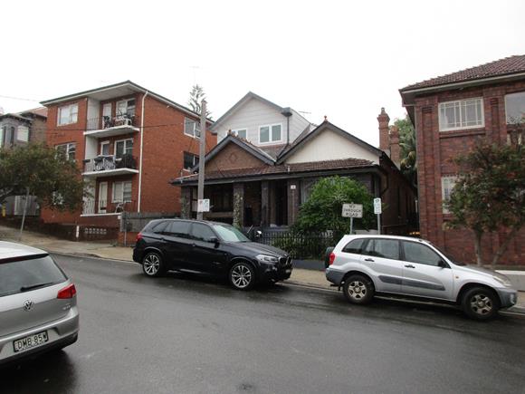
Existing dwelling at No.12 Vicar Street and adjoining semi detached dwelling at No.14 Vicar Street
Submissions
The owners of adjoining and likely affected neighbouring properties were notified of the proposed development in accordance with the Randwick Comprehensive DCP 2013. The following submissions were received as a result of the notification process:
|
Issue |
Comment |
|
113 Brook Street Coogee
-The proposal will have a significant impact on and result in their current view being obstructed.
-The loss of the view will detract from the heritage significance of their dwelling which is a listed heritage item.
-The proposal does not comply with the objectives of Clause 4.3 of the RLEP, in relation to height, heritage impact and sea views.
|
See consideration of view loss in the Key Issues Section below.
See consideration of heritage issues in the Key Issues Section below.
The proposal complies with the maximum building height in the RLEP and the maximum wall height control in the DCP. See consideration in the Key Issues Section below and the attached compliance report. |
Key Issues
Views
Under Section 4.3 of the Development Control Plan for Dwellings and Attached Dual Occupancies a performance requirement is that buildings are designed to allow for a sharing of view loss. The Land and Environment Court has established a four step analysis of view loss in Tenacity v Warringah Council (2004).
The Commissioner in deciding whether or not view sharing was reasonable adopted the following planning principle.
a) The first step is the assessment of views to be affected. Water views are valued more highly than land views. Iconic views (e.g. of the Opera House, the Harbour Bridge or Headland) are valued more highly than views without icons. Whole views are valued more highly than partial views, e.g. a water view in which interface between land and water is visible is more valued than one in which it is obscured.
b) The second step is to consider from part of the property the views are obtained. For example the protection of views across side boundaries is more difficult that the protection of views from front and rear boundaries. In addition, whether the view is enjoyed from a standing or sitting position may also be relevant. Sitting views are more difficult to protect than standing views. The expectation to retain side and sitting views is often unrealistic.
c) The third step is to assess the extent of the impact. This should be done for the whole property, not just for the view that is affected. The impact on views from living areas is more significant than from bedrooms or service areas (though views from kitchens are highly valued because people spend so much time in them) The impact may be assessed quantitatively, but in many cases this can be meaningless. For example, it is unhelpful to say that the view loss is 20% if it includes one of the sails of the Opera House. It is usually more useful to assess the view loss qualitatively as negligible, minor, moderate, severe or devastating.
d) The fourth step is to assess the reasonableness of the proposal that is causing the impact. A development that complies with all planning controls would be considered more reasonable that one that breaches them. Where an impact on views arises as a result of non-compliance with one or more planning controls, even a moderate impact may be considered unreasonable. With a complying proposal, the question should be asked whether a more skilful design could provide the applicant with the same development potential and amenity and reduce the impact upon the views of neighbours. If the answer to that question is no, then the view impact of a complying development would probably be considered acceptable and the view sharing reasonable.
In relation to view impacts as submission has been received from the owner of the premises behind at No.113 Brook Street which raise concerns regarding the impact that the development will have upon the existing views from their premises across the subject premises.
a) The view in question is an ocean water view which is across and in front of the subject property and those properties to the front of that property.
b) The views are obtained from the rear of the premises at 113 Brook Street Coogee. The view is available from a standing position at the rear of the living room windows. See photo above, which is taken from the rear living room of No. 113 Brook Street. This photo also includes the existing upper level at No.14 Vicar Street which is the adjoining semi detached dwelling to the subject property.
c) The proposal will remove approximately half of the existing view because of the roof pitch of the new upper level. The current view only exists because the subject property has not been developed to its extent as has the adjoining semi detached dwelling. The view is from the rear living area and is primarily enjoyed from a standing position. The view loss is considered to be moderate.
d) The proposal is reasonable as it satisfies all of the relevant assessment criteria in the RLEP and Development Control Plan. It is noted that the roof pitch of the new upper level matches the adjoining semi detached dwelling which is an important and relevant consideration in the Building Design section in Part 4.2 of the RDCP, which requires that alterations and additions to a semi detached dwelling must recognise that the dwelling is half of a pair of symmetrical dwellings, and that the existing architectural expression and symmetry of the dwellings as a coherent entity is respected. A portion of the existing view may be retained by a skillion type roof instead of the proposed pitched roof, however the benefit of that would is outweighed by the detrimental impact upon the streetscape of Vicar Street by the imposition of one half of a semi detached dwelling which is significantly out of character with the adjoining semi detached dwelling.
Heritage
The subject premises adjoins a heritage item, No.113 Brook Street Coogee, which is listed in Schedule 5 of the RLEP.
Under Clause 5.10 of the RLEP consideration must be given to the impact that the development may have upon the significance of the adjoining heritage item.
The proposal has been considered by Council’s Consultant Heritage Planner who has provided the following comments;
The relationship of the existing residence at 12 Vicar Street to the listed residence at 113 Brook Street is limited by virtue of offset, the existing additions to 14 Vicar Street and the rise of ground from Vicar to Brook Streets. Views from the rear of 113 Brook Street may well be impeded by the proposed development but appear to be at a higher level than sightlines toward the listed residences from Vicar Street, these being already blocked by the existing form of 12 Vicar Street. In other words the impact on street views to the listed building at 113 Brook Street is not considered to be substantially impacted. The impact upon views from the listed residence at 113 Brook Street is considered not to be associated with views from this listed building from Vicar Street but an outlook from the rear of 113 Brook Street. This needs to be assessed under amenity rather than heritage issues.
Landscaping
The objectives of Part 2.4 of the RDCP in relation to landscaping seek to;
a) Ensure landscaped areas are effectively distributed on the site to achieve a visual balance between building structures and open space,
b) Provide privacy screening between dwellings,
c) Retain and provide for canopy trees and large shrubs to contribute to the establishment of vegetation corridors across the locality, and
d) Assist with stormwater infiltration and reduction of overland flow.
The resultant area of landscaping represents 4% of the site area which does not comply with the minimum of 20% as detailed in the DCP controls. The existing area of landscaping on the site is at 12% of the site area. The reduction in landscaping results primarily from the installation of the car space to the front of the dwelling and the rear addition. Whilst the variation appears to be numerically large in the circumstances of a small and constrained site, the areas of proposed soft landscaping are appropriate to the scale of spaces relative to the building and distributed on the site in a manner that achieves a good level of amenity for the occupants of the dwelling.
Relationship to City Plan
The relationship with the City Plan is as follows:
Outcome 4: Excellence in urban design and development.
Direction 4a: Improved design and sustainability across all development.
Financial impact statement
There is no direct financial impact for this matter.
Conclusion
The proposal complies with the relevant assessment criteria and will not result in any significant adverse impacts upon either the amenity of the adjoining premises or the character of the locality.
The application is therefore recommended for approval subject to the attached conditions of consent in the compliance report.
|
That Council, as the consent authority, grants development consent under Sections 80 and 80A of the Environmental Planning and Assessment Act 1979, as amended, to Development Application No. 333/2017 for alterations and additions to the existing dwelling at 12 Vicar Street Coogee subject to the following non standard conditions and the standard conditions contained in the development application compliance report.
|
|
1.⇨ |
DA Compliance Report - 12 Vicar Street, COOGEE |
Included under separate cover |
Planning Committee 14 November 2017
Development Application Report No. D87/17
Subject: 70-82 Belmore Road Randwick (DA/488/2017)
Folder No: DA/488/2017
Author: Perry Head, Environmental Planning Officer
Proposal: Fitout and use of existing the existing premises as a remedial massage shop including signage (Heritage Item and Heritage Conservation Area).
Ward: West Ward
Applicant: Lati Studio Pty Ltd
Owner: SP 1527
Summary
Recommendation: Approval
|
|
|
|
Subject Site |
|
|
|
|
|
|
|
|
|
|
|
|
|
|
Submissions received
|
|
|
Ù North
|
|
|
Locality Plan |
Development Application Executive summary report
The application is referred to the Planning Committee for determination as it proposes to use the premises for massage purposes.
Proposal
The proposal details the fit out and use of the premises as a remedial massage use consisting of 4 massage tables separated by a combination of partition walls and curtains, a reception area and waiting area. There is an existing hand wash basin and toilet facilities. The existing glazed shop front will be retained and new signage provided.
The massage therapy will employ a maximum of 5 persons, 4 masseurs and 1 receptionist and operate 9.30am to 9.30pm seven days a week.
Site
The site is on the western side of Belmore Road and contains a three storey building listed as a heritage item which has commercial uses on the ground floor and dwellings above.
Existing premises
Submissions
The owners of adjoining and likely affected neighbouring properties were notified of the proposed development in accordance with the Randwick Comprehensive DCP 2013. No submissions have been received.
Key Issues
Hours of Operation
The proposed operating hours are 9.30am to 9.00pm seven days a week. The proposed operating hours are considered to be consistent with other commercial premises along Belmore Road. The proposed massage business is located on the ground floor level of a mixed use building which is considered a suitable location given that the proposed use will not generate adverse noise or a large number of patrons at any given time. Therefore the proposed hours of operation will not result in any adverse impacts to the adjoining residential and commercial development in terms of noise generation or parking demands.
The proposed use and hours of operation are considered to be consistent with the relevant objectives of the RLEP 2012 and RCDCP 2013 and will not result in any significant adverse environmental impacts.
Heritage
The site is occupied by a three storey building which comprises ground level shops and upper level commercial and residential uses is listed as a heritage item under the Randwick LEP 2012. The building makes a significant contribution to the streetscapes of Belmore Road and Arthur Lane and also has historical significance as a later part of the Inter War residential development boom in Randwick and the demand for apartment style housing.
The proposal has been considered by Council’s Heritage Planner who advises that there are no objections to the proposed fitout and use as there are no original walls or ceilings within the retail tenancy. It is noted that the proposed signage will result in visual clutter and dominate and obscure the detail of the building. Consent conditions are included which require that no signage be provided to either side of the shopfront and that the top hamper signage not extent all the way to the underside of the awning. Conditions of consent are included to address these issues and also to require amended drawings to be submitted to and approved by Council prior to a construction certificate being issued.
NSW Police Crime Risk Assessment Report
The proposal was referred externally to the NSW Police Local Area Command who provided standard recommendations regarding surveillance, access control, territorial reinforcement and space and activity management. The report concluded that by using the treatments recommended (as referred to in condition 8 of this report) criminal activity will be reduced and the safety of members of the community and the security of their property increased.
Section 79C Assessment:
The site has been inspected and the application has been assessed having regard to Section 79C of the Environmental Planning and Assessment Act, 1979, as amended.
|
Section 79C ‘Matters for Consideration’ |
Comments |
|
Environmental Planning Instruments |
|
|
Section 79C(1)(a)(i) – Provisions of any environmental planning instrument |
Randwick Local Environmental Plan 2012 The site is zoned Local Business B2 under Randwick Local Environmental Plan 2012 and the proposal is permissible with Council's consent. The premises is a building which contains a heritage item and therefore as required by Clause 5.10 of the RLEP consideration must be given to the impact that development may have upon the significance of the heritage item. See comments in the Key Issues above. The proposal will promote the specific objectives of the zone by enhancing employment opportunities and servicing the needs of local and regional residents thereby ensuring the commercial viability of the town centre. It will also protect the amenity of residents in the neighbouring residential zones. |
|
Section 79C(1)(a)(iii) – Provisions of any development control plan |
The proposal generally satisfies the RCDCP 2013. |
|
Section 79C(1)(a)(iv) – Provisions of the regulations |
The relevant clauses of the Regulations have been satisfied. |
|
Section 79C(1)(b) – The likely impacts of the development, including environmental impacts on the natural and built environment and social and economic impacts in the locality |
The environmental impacts of the proposed development on the natural and built environment, which are otherwise not addressed in this report, are discussed in the paragraphs below.
The proposed development is consistent with the dominant character in the locality. The proposal is not considered to result in detrimental social or economic impacts on the locality.
|
|
Section 79C(1)(c) – The suitability of the site for the development |
The site is located in close proximity to local services and public transport. The tenancy has sufficient area to accommodate the proposed land use. Therefore, the tenancy is considered suitable for the proposed development. |
|
Section 79C(1)(d) – Any submissions made in accordance with the EP&A Act or EP&A Regulation
|
There were no submissions. |
|
Section 79C(1)(e) – The public interest |
The proposal promotes the objectives of the zone and will not result in any significant adverse environmental, social or economic impacts on the locality. Accordingly, the proposal is considered to be in the public interest.
|
Relationship to City Plan
The relationship with the City Plan is as follows:
Outcome 4: Excellence in urban design and development.
Direction 4a: Improved design and sustainability across all development.
Financial impact statement
There is no direct financial impact for this matter.
Conclusion
The proposal has been assessed against the requirements of the relevant planning guidelines of the RLEP and Council policies and plans as well as in regard to Section 79C of the Environmental Planning and Assessment Act 1979, as amended. The proposal will not result in significant adverse environmental impacts upon the amenity and character of the locality and will be not inconsistent with the relevant objectives and criteria of the RLEP 2012 and the RCDCP 2013.
Further, it is considered that the proposal is for a legitimate massage premises and not for any form of sexual service use. The proposal is therefore recommended for approval, subject to conditions.
|
That Council, as the consent authority, grants development consent under Sections 80 and 80A of the Environmental Planning and Assessment Act 1979, as amended, to Development Application No. 488/2017 for the fit out and use of the existing commercial tenancy as a massage therapy use at 78 Belmore Road Randwick, subject to the following non standard conditions and the standard conditions contained in the development application compliance report attached to this report:
Non standard conditions;
2. The minimum clear distance from the existing footpath in Belmore Road to the underside of the proposed under-awning advertising sign, (i.e. the sign to be installed above the footpath in Belmore road), shall be 2.60 metres.
3. No signage is to be provided to the masonry surfaces on either side of the shopfront and existing signage in this area is to be removed, in order to be consistent with signage provision to other retail tenancies within building, and to avoid visual clutter resulting from excessive signage. Amended drawings are to be are to be submitted to and approved by Council’s Manager Development Assessment, in accordance with Section 80A (2) of the Environmental Planning and Assessment Act 1979 prior to a construction certificate being issued for the development.
4. Further detail is to be provided of any proposed top hamper/bulkhead signage. Any proposed signage should be consistent with the depth of other top hamper/bulkhead signage to other retail tenancies within the building. Details of any proposed top hamper/bulkhead signage are to be submitted to and approved by Council’s Manager Development Assessment, in accordance with Section 80A (2) of the Environmental Planning and Assessment Act 1979 prior to a construction certificate being issued for the development.
5. Further detail is to be provided of any proposed awning fascia signage. Any proposed awning fascia signage should not exceed the depth of the existing awning fascia. Details of any proposed awning fascia signage are to be are to be submitted to and approved by Council’s Manager Development Assessment, in accordance with Section 80A (2) of the Environmental Planning and Assessment Act 1979 prior to a construction certificate being issued for the development.
6. Further detail is to be provided of new signage within the proposed under awning sign box. Details of any proposed awning fascia signage are to be are to be submitted to and approved by Council’s Manager Development Assessment, in accordance with Section 80A (2) of the Environmental Planning and Assessment Act 1979 prior to a construction certificate being issued for the development.
7. The colours, materials and finishes of the shopfront are to be compatible with other shops within the existing building and surrounding buildings in the heritage conservation area, and consistent with the architectural style of the building. Details of the proposed colours, materials and textures (ie- a schedule and brochure/s or sample board) are to be submitted to and approved by Council’s Manager Development Assessment, in accordance with Section 80A (2) of the Environmental Planning and Assessment Act 1979 prior to a construction certificate being issued for the development.
Crime Prevention through Environmental Design 8. The development must in undertaken in accordance with the recommendations of the NSW Police Force’s “Crime Risk Assessment” of the development received by Council on 3 November 2017. Details shall be provided at the construction certificate stage, to the satisfaction of the certifying authority.
20. The owner of the subject site must advise Council in writing of any change in the tenant that is operating the massage shop and advise the new tenant that they must provide Council with the qualifications of all staff involved in providing massage services prior to commencing the new operation.
21. The premises must only be used for the purposes of remedial massage. The premises must not to be used for the purposes of a brothel and in this regard, no sexual services of any kind are to be offered in association with the massage use.
22. The maximum number of employees operating from the subject premises is restricted to 5, and their relevant remedial and therapeutic massage qualifications are to be submitted to and approved by Council’s Manager Development Assessment prior to the commencement of the use or when there are new employees.
|
|
1.⇨ |
DA Compliance Report - 70-82 Belmore Road, RANDWICK |
Included under separate cover |
Planning Committee 14 November 2017
Development Application Report No. D88/17
Subject: 4/199-203A Malabar Road, South Coogee (DA/153/2015/A)
Folder No: DA/153/2015/A
Author: Louis Coorey, Senior Environmental Planning Officer
Proposal: Review of condition relating to operating hours
Ward: East Ward
Applicant: Mr and Mrs Allison
Owner: Owners SP10179
Summary
Recommendation: Approval
|
|
|
|
Subject Site |
|
|
|
|
|
|
|
|
|
|
|
|
|
|
Submissions received
|
|
|
Ù North
|
|
|
Locality Plan |
Development Application Executive summary report
The application is referred to Planning Committee as the reviewable condition relates to hours of operation which were the subject of section 96 application determined by Council.
Proposal
The proposal seeks to make permanent the temporary trading hours of the café and footpath trading imposed under condition 35 of DA/153/2015/A as follows:
Operational Hours
35. The operating hours of the café including the footpath dining area must be restricted to the following and are subject to a review period in accordance with Section 80A (10B) of the Environmental Planning & Assessment Act 1979 and Division 14 of the Environmental & Assessment Regulation 2000:
· Sunday to Thursday: 7:00am – 8.30pm
· Friday & Saturday: 7:00am – 9.30pm
Footpath trading:
• Sunday to Thursday: 7.00am - 6.00pm
• Friday & Saturday: 7:00am – 9.30pm
All food services to customers in footway dining area shall only be provided within the abovementioned hours of operation and all patrons must vacate the area and all outdoor furniture is to be removed within 30 minutes of the specified hours.
The operating hours will be reviewed by Council in six months and at the end of twelve months from the date of this amended consent. Appropriate supporting evidence (including but not limited to, relevant acoustics measurements) must be provided at the end of these review periods to demonstrate compliance with all conditions of this consent as part to the review.
Background
· DA/153/2015: Consent was granted (18 May 2015) for the fit out and use of the premises as a café with outdoor dining (maximum of 14 seats), parking at the rear and waste services area. The hours of operation were the subject of a reviewable condition (condition 35)
Operational Hours
35. The operating hours of the café including the footpath dining area must be restricted to the following and are subject to a review period in accordance with Section 80A (10B) of the Environmental Planning & Assessment Act 1979 and Division 14 of the Environmental & Assessment Regulation 2000:
· Sunday to Thursday: 7:00am – 6:00pm
· Friday & Saturday : 7:00am – 9:30pm
All food services to customers in footway dining area shall only be provided within the abovementioned hours of operation and all patrons must vacate the area and all outdoor furniture is to be removed within 30 minutes of the specified hours.
The operating hours will be reviewed by Council within 12 months of the date of commencement of the café including footpath dining area. The operator of the premises must advise Council in writing of the date of commencement. Appropriate supporting evidence (including but not limited to, relevant acoustics measurements) must be provided at the end of the review period to demonstrate compliance with all conditions of this consent as part to the review.
· Section 96 “A” DA/153/2015/A: Consent was granted 25 October 2016. A reviewable condition (subject to 6 months and 12 months review) approved the following change to condition 35:
Operational Hours
35. The operating hours of the café including the footpath dining area must be restricted to the following and are subject to a review period in accordance with Section 80A (10B) of the Environmental Planning & Assessment Act 1979 and Division 14 of the Environmental & Assessment Regulation 2000:
· Sunday to Thursday: 7:00am – 8.30pm
· Friday & Saturday : 7:00am – 9.30pm
Footpath trading:
· Sunday to Thursday: 7.00am - 6.00pm
· Friday & Saturday: 7:00am – 9.30pm
All food services to customers in footway dining area shall only be provided within the abovementioned hours of operation and all patrons must vacate the area and all outdoor furniture is to be removed within 30 minutes of the specified hours.
The operating hours will be reviewed by Council in six months and at the end of twelve months from the date of this amended consent. Appropriate supporting evidence (including but not limited to, relevant acoustics measurements) must be provided at the end of these review periods to demonstrate compliance with all conditions of this consent as part to the review.
The S96 “A” also approved an increase in seating from 14 to 20 seats (less than the 40 and then 28 originally sought by applicant). The footpath trading hours were not changed. Conditions were added retaining a car space in the rear courtyard, delivery vehicles to park on Malabar Road and waste management.
Site
The subject site occupies a ground level commercial premises at the southern end of the site wrapping around Malabar Road and Denning Street. The site is operating as a café with footpath dining. The properties to the north are other commercial premises with frontages to Malabar Road and located within the B1 Neighbourhood Zone which permits commercial premises. Located above the premises at first floor level is a residential unit. The surrounding properties to the east along Denning Street and west along Malabar Road are residential development containing a mixture of single dwellings, multi-unit flats and semi-detached dwellings located in the R2 low density residential zone. Opposite the site to the south is a Reserve owned by the Crown and under the control of Council.
The most notable neighbouring properties include an apartment directly above the shop premises and the residential dwellings to the east on the eastern side of Denning Street, several of which have made submissions.
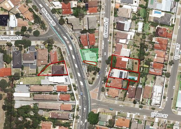
Aerial image of the site and surrounding area. Note Red outline over the subject site (bounded in green) identifies the unit above the café premises. Green shading identifies the whole of the site known as 199-203A Malabar Road which contains strata shops and 1st floor residences/ancillary above. The rear of these properties face Denning Street.
Submissions
The owners of adjoining and likely affected neighbouring properties were notified of the proposed development in accordance with the Randwick Comprehensive DCP 2013. The following submissions were received as a result of the notification period:
· 5/199-203A Malabar Road, South Coogee
· 79 Denning Street, South Coogee
· 202 Malabar Road South Coogee
· 1/92 Denning St, South Coogee
· 81 Denning Street, South Coogee
· 77 Denning Street, South Coogee
|
Issue |
Comment |
|
Café has operated only on several occasions during the later opening time and therefore it does not provide an accurate measure of compliance. It is also noted that during times where they have operated near to closing times they have operated outside these hours.
The acoustic report in the previous S96 application had flaws and should never have been relied upon to allow for hours between 6pm and 7am |
The applicant submitted an acoustic report with this application to review the operating hours. An independent assessment of the application has been undertaken by Council Officers. Council has not relied solely upon the information provided by the applicant in the assessment of the current application to review the operating hours. Due regard has been given to investigations by Council Rangers.
See discussion under Key issues section of this report. |
|
Illegal parking over the driveway impeding and redirecting pedestrian traffic along the roadway compromising safety |
This matter has been referred to Council Rangers for investigation. |
|
Rubbish such as coffee cups surrounding the premises |
A condition is included requiring a staff member to be responsible for a walk through around the shop premises along Malabar Road, Denning Street and the Reserve to pick up litter associated with the shop premises. |
|
The premises has operated before 7am and after the nominated closing times on occasion. Live music (microphone) has also been conducted on site. |
See key issue section. |
|
Sewerage smell when they empty their waste trap |
This matter has been referred to Council’s Environmental Health Section for investigation. |
Key issues
· Request for review
As part of the review a request for information was made to the Applicant as follows:
As Council has received noise complaints during the trial period could you please provide the following information within 21 days from the date of this letter to enable the review to be undertaken:
1. An acoustic report, prepared by a suitably qualified and experienced consultant in acoustics, which demonstrates and confirms that the relevant provisions of the Protection of the Environment Operations Act 1997 and the noise criteria and requirements contained in this consent continues to be satisfied (including reference to the relevant approved acoustic report and recommendations). The assessment must include (but not be limited to):
· Monitoring from the nearest affected residential units located above 5/199 Malabar Road
· Monitoring and assessment during the use and operation of the premises when live entertainment is being provided and greater occupancy is present,
· Compliance monitoring shall be carried out during the times when the nearby residential and public domain areas are likely to be most affected, this shall include (but not be limited to) the hours of operation on a Friday and/or Saturday night,
· Ensure the break out of any internal noise complies with the set criteria. If not, nominate the necessary and required measures to ensure compliance (this may include controlling live entertainment; controlling internal noise; provision of sound locks; other management practices as deemed appropriate and necessary),
· The report must include all relevant fixed and operational noise sources.
· The report must detail compliance with Condition 33, 35, 82 and 83 of the DA/153/2015/A
2. Details of all complaints received and the manner in which they were dealt with and resolved.
In response the Applicant provided the following documentation:
1. An acoustic report (R150494R1) dated 3 July 2017 that conducted noise levels conducted during the breakfast period of Sunday 25 June 2017 and not during the later hours of operation that is after 7pm when disturbance of neighbouring properties was of most concern.
2. A statement responding to the complaints received by Council from the time of beginning operations (early November).
· Customer Service Requests (CRM’s)
There have been a number of reports made to Council and investigations about the operation of the premises during that period. These are detailed below:
o 1 November 2016: CRM report opening earlier than permitted;
o 14 November 2016: Ranger reports service of customers before 7am;
o 15 November 2016: Ranger reports service of customer before 7am;
o 16 November 2016: Ranger reports closed at 5pm;
o 19 November 2016: Ranger reports people leaving with coffee before 7am;
o 21 November 2016: Ranger reports seating placed on footpath prior to 7am;
o 23 November 2016: Ranger reports several people being served before 7am;
o 24 November 2016: Ranger reports several customers served and inside café before 7am;
o 4 December: CRM report of noise from within the premises and table and chairs on footpath outside hours of operation;
o 5 December 2016: Ranger reports tables and chairs outside after hours and bay windows open
o 16 December 2016: CRM reports staff delivering coffee to person in bus zone;
o 19 December: CRM reports footpath is blocked;
o 12 February: CRM reporting loud music and too many customers; Ranger reports music not offensive; Ranger investigates later and reports seating outside premises at 7:40pm after 6pm limit for footpath seating on Sunday;
o 25 April 2017: CRM reports excessive noise; Ranger investigated no noise concerns;
o 13 May 2017: CRM report of loud music; Ranger reports loud music heard from street;
o 14 May 2017: CRM reports (from two neighbour’s) of loud music (stopping and starting); Ranger reports no loud music (observes microphone setup in premises);
· Operation and management
In summary, the Customer Service Requests (CRM’s) received by Council and investigated by Council Rangers relate to:
· Placing furniture on the footpath and serving customers earlier than the 7am, permitted
· Excessive noise from amplified music emanating from within the premises during permitted times;
· Excessive noise from the rear of the premises through open windows and doors directly connected to the café’s kitchen
· Footpath seating and or trading on two Sundays longer than permitted;
Council officers have investigated and verified the following:
· Furniture placed and/or serving customers earlier than the 7am on seven occasions
· Footpath trading occurred later than (6pm) permitted on two Sundays (4 December and 12 February) and
· Loud breakout noise associated with amplified music from within the premises during the permitted operating time
Applicant’s response:
As part of the review process, the Applicant responses to the above reports acknowledging they have operated earlier than the permitted 7am opening time and that they have undertaken a change in opening procedures to rectify this by only placing furniture outside during the permitted hours. The Applicant also confirms on two Sundays they had furniture on the footpath later than permitted and that this was three months apart and related to team bonding session and no commercial activity.
· Noise and hours of operation
An acoustic report has been submitted in support of the review. Councils Senior Environmental Health Officer has reviewed the acoustic report and notes the following:
For an acoustic validation to address issues of acoustic compliance the following elements would need to be included:
· Assessment of the operation of the premises during the extended operational hours, particularly night time;
· Consideration of sensitive receiver and measurement if permissible directly above the premises in terms of acoustic compliance.
At this stage it is considered the acoustic report has not demonstrated compliance with required acoustic criteria as the report covers a day time period during Sunday only.
The fact that the acoustic report has not conducted a noise assessment during the later opening times is of particular concern as the closing times are the subject of review.
Opening times
The proponent placed furniture on the footpath earlier than permitted on at least seven occasions verified by Councils Rangers. It is noted however, that an assessment of the CRM’s received by Council following mid-December 2016 reveals no significant complaints regarding the placement of footpath furniture or serving customers earlier than permitted. Therefore it is recommended that the opening time of 7am remain for the premises for a further trial period.
Closing times
In relation to the closing times, several submissions received as part of this review report the café hasn’t generally operated during the extended hours and generally closed its doors between 4pm and 6pm every day. The concern raised is that if the premises hasn’t operated during the extended hours how can it be demonstrated that there is compliance with the relevant conditions. Whilst it cannot be confirmed that the premises has not consistently operated during the extended hours, it can however be said that the Applicant has demonstrated an ability to comply with the opening times permitted for a considerable period (for around 11 months out of the 12 months since the S96”A” determination) and the Applicant has generally addressed the waste management concerns in relation to collection. In addition, there has only been two occasions during the 6 month period that the applicant has placed furniture on the footpath after the permitted hours.
Based on the above, it is recommended that the closing times be retained as approved in condition 35 in the S96 “A” application for a further reviewable period. However, in order to accurately determine compliance with the noise criteria with the premises operating at capacity or close to its maximum capacity, it is recommended that condition 33 be amended to require noise measurements during the extended hours to be undertaken for a consecutive period of four weeks of operation and to include break out noise.
Overall, maintaining condition 35 and amending condition 33 will ensure a comprehensive review of the hours of operation.
Footpath seating
Only two CRM’s were received by Council in relation to the footpath area being blocked since the increase in outdoor seating from 14 to 20 seats. Council Rangers investigated and found that the number of tables and seats were compliant with the DA consent condition. There are no significant concerns with the number of tables and chairs on site and the applicant has reasonably demonstrated that the number of tables and chairs can fit within the area approved by Council.
Deliveries and pedestrian safety
Several CRM’s and submissions were received from a Denning Street resident showing that vehicles (including delivery vehicles) park over the driveway entrance and pedestrian footpath off Denning Street impeding pedestrians travelling along the footpath requiring the use of the road way to pass which is unsafe. The Applicant has indicated that they have “warned suppliers to deliver only during delivery times” which does not address the delivery vehicles using Denning Street to make deliveries. Notwithstanding, parking over the driveway is illegal and administered by Council Rangers and Police. In relation to the delivery vehicles, a condition was included requiring the use of the Loading bay along Malabar Road. It is noted that this does not preclude the movement of deliveries through the rear of the shop off Denning Street which is acceptable.
Waste Management
Several CRM’s and submissions have been received regarding the disturbance from garbage trucks operating during the early morning period, the increase in rubbish such as coffee cups around the premises in the public domain and smells from removing the grease trap waste.
In relation to garbage removal, the Applicant indicates that they have changed from a private waste management contractor to Randwick Council commercial waste management which has significantly reduced the noise complaints from neighbouring properties. In relation to the waste in the public domain around the cafe, it is noted that the public have a degree of responsibility to get rid of rubbish appropriately and that there is a street bin located in close proximity to the site. Condition 44 of the original determination does require the business proprietor and staff to ensure that the footpath dining area (and the immediate vicinity adjacent to the footpath dining area) is maintained in a clean and tidy condition at all times, free of grease, food and litter. No further waste conditions are considered necessary.
Relationship to City Plan
The relationship with the City Plan is as follows:
Outcome 6: A livable City.
Direction 6b: Our town centres, beaches, public places and streets are safe, inviting, clean and support a recognisable image of our city.
Direction 6c: The safety of our community is paramount and is acknowledged and supported through proactive policies, programmes and strategies.
Financial impact statement
There is no direct financial impact for this matter.
Conclusion
In circumstances where the Applicant has mostly demonstrated compliance with the conditions consent, it is considered reasonable to recommend that the closing times be retained as approved in condition 35 in the S96 “A” application for a further reviewable period and the requirement for an acoustic report be submitted to Council identifying noise measurements during the extended hours of review to be undertaken for a consecutive period of four weeks of operation.
|
That Council, as the consent authority, amends development consent under Section 80 (10B & 10D) of the Environmental Planning and Assessment Act 1979, as amended to the operation for the food premises, at No. 4/199-201 Malabar Road, South Coogee, by amending DA/153/2015 in the following manner:
· Amend Condition No. 33 to read: Environmental Amenity 33. An acoustic report from a suitably qualified and experienced consultant in acoustics for the subject development shall be provided to Council within 2 months of the date of this determination (covering a four week period) and from time to time as reasonably requested by Council, which demonstrates and certifies that noise from the use and operation from the development during the extended hours contained in Condition No. 35and when the premises is at or near capacity complies with the relevant provisions of the Protection of the Environment Operations Act 1997, NSW EPA/DECC Noise Control Manual & Industrial Noise Policy and conditions of Council’s consent.
The acoustic report is to include (but not be limited) to:
· Noise emission from the proposed development (e.g. operational noise, mechanical noise, monitoring from nearest affected residential premises during the use and operation of the premises when at or near capacity occupancy to satisfy intrusiveness and amenity criteria),
· Monitoring and assessment during the use and operation of the premises when live entertainment is being provided and greater occupancy is present,
· Break out of any internal noise complies with the set criteria. If not, nominate the necessary and required measures to ensure compliance (this may include controlling live entertainment; controlling internal noise; provision of sound locks; other management practices as deemed appropriate and necessary),
· Patron noise from the development having regard to the footway dining (at or near maximum capacity) and the hours of operation (across the hours of operation),
· Background noise levels shall be in the absence of any other businesses operating in the area,
· The validation acoustic report shall be conducted at the nearest sensitive receivers including but not limited to residential occupancies above 199-203A Malabar Road, South Coogee and in the vicinity of the site. A copy of the report is to be forwarded and approved by Council.
· Amend Condition No. 35 to read: Operational Hours 35. The operating hours of the café including the footpath dining area must be restricted to the following and are subject to a review period in accordance with Section 80A (10B) of the Environmental Planning & Assessment Act 1979 and Division 14 of the Environmental & Assessment Regulation 2000:
· Sunday to Thursday: 7:00am – 8.30pm · Friday & Saturday : 7:00am – 9:30pm
All food services to customers in footway dining area shall only be provided within the abovementioned hours of operation and all patrons must vacate the area and all outdoor furniture is to be removed within 30 minutes of the specified hours.
The operating hours will be reviewed by Council within 6 months of the date of determination of this application. The operator of the premises must advise Council in writing of the date of commencement. Appropriate supporting evidence (including but not limited to, relevant acoustics measurements) must be provided at the end of the review period to demonstrate compliance with all conditions of this consent as part to the review.
|
Nil
Planning Committee 14 November 2017
Development Application Report No. D89/17
Subject: 81-85 Frenchmans Road, Randwick (DA/599/2008/B)
Folder No: DA/599/2008/B
Author: Louis Coorey, Senior Environmental Planning Officer
Proposal: Section 96 modification of the approved development by extension of trading hours to 24 hours, 7days
Ward: North Ward
Applicant: Veterinary Supply Limited Trust
Owner: Tanert Pty Ltd
Summary
Recommendation: Refusal
|
|
|
|
Subject Site |
|
|
|
|
|
|
|
|
|
|
|
|
|
|
Submissions received
|
|
|
Ù North
|
|
|
Locality Plan |
Development Application Executive summary report
The application is referred to Council as the original application was determined by Council.
Proposal
The current application seeks to modify the consent granted under DA/599/2008 by extending the approved trading hours of the existing Veterinary establishment, including surgery to operate 24 hours a day seven days a week with no change to grooming hours (see existing hours below). The applicant indicates 2-3 staff members will be on duty from 9pm to 11pm and it is expected 2-4 customers will attend between the hours of 11pm and 7am. The SEE states the additional hours provide flexibility for clients and emergencies. The application nominates the existing parking in the rear.
Particulars: The existing hours in condition 8 of the original consent (DA/599/2008) separate surgery hours and grooming hours as follows:
|
Veterinary surgery |
|
|
Monday to Friday |
7am to 9pm |
|
Saturday |
9am to 6pm |
|
Sunday and Public Holidays |
9am to 6pm |
|
Grooming |
|
|
Monday to Friday |
8am to 6pm |
|
Saturday |
9am to 1pm |
|
Sunday and Public Holidays |
Closed |
Site
The subject site comprises Lots 4, 5 and 6 in DP 259676, Nos. 81-85 Frenchmans Road, Randwick. The site is located on the north-western side of Frenchmans Road, opposite to its intersection with Kemmis Street. The combined dimension and land area of the site are summarised in the table below:
|
Boundary |
Length |
Land area |
|
North-western, rear boundary |
19.0m |
|
|
South-eastern, Frenchmans Road boundary |
18.5m |
|
|
North-eastern, side boundary |
37.7m |
|
|
South-western, side boundary |
40.7m |
|
|
Land area |
|
Approximately 720.8m2 |
The subject site sits within a group of properties at Nos. 75-85 Frenchmans Road (Lots 1-6 in DP 259676) that comprise a row of 6 x semi-detached double-storey terrace buildings with retail services at ground level and shop top housing or ancillary service use above. The above properties are under the same ownership. A common car park to the rear services all of the six buildings. Vehicular access is obtained via a driveway crossing off Roscrea Avenue.
At present, the veterinary establishment “Vet Med” has operated from Nos. 81, 83 and 85 the three premises since the end of 2008. The other premises comprise 1 x restaurant, 1 x food preparation premises and 1 x Speech Pathology premises occupying the ground floor level of Nos. 75, 77 and 79 respectively. The entire complex occupies a land area of approximately 1394m2.
The common car park at the rear provided for 8 out of 14 carspaces for use by the veterinary surgery and grooming salon.
Nearby residential properties:
The complex is adjoined at the rear by a detached dwelling to the north-west at No. 11 Roscrea Avenue and other residential dwellings to the north. A development site for 4 storey shop top housing development (87-89 Frenchmans Road) adjoins the site on its north-eastern boundary along Frenchmans Road. On the opposite side of Frenchmans Road and Kemmis Street are residential dwellings located within the low (R2) to medium (R3) density residential zones. The locality is characterised by a mixture of retail and commercial premises and low to high density residential developments.
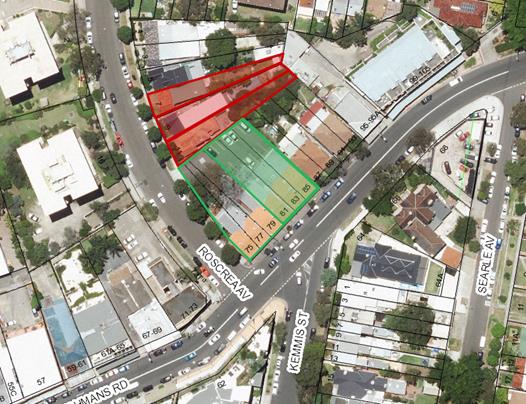
Aerial Photo: Shows the subject site shaded green including the larger complex bounded in green. Access to the carpark is off Roscrea Avenue at the rear.
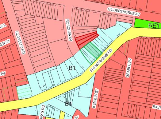
Aerial map of zoning: B1 Neighbourhood Centre shaded light blue; R2 low density zone shaded pinkish and R3 medium density zone shaded red.
Submissions
The owners of adjoining and likely affected neighbouring properties were notified of the proposed development in accordance with the Randwick Comprehensive DCP 2013. The following submissions were received as a result of the notification process:
· 7 Roscrea Avenue, Randwick
· 9 Roscrea Avenue, Randwick
· 11 Roscrea Avenue, Randwick
|
Issue |
Comment |
|
Noise impact from use of the driveway alongside the residential premises during the late night operation |
Acknowledged, whilst the car park services other premises and some residential components and therefore cannot restrict access, it is considered that noise associated with a commercial use would be significant and beyond that reasonably expected from a residential use. |
|
A sensor light shines into the back yard at night |
An appropriate condition was included in the original consent. This matter has been referred to Councils Building and Regulatory Compliance section. |
|
Environmental damage to the footpath and parks due to increased number of people walking pets during the late night and early morning period. |
There are adequate conditions in place attached to the original determination in relation to minimising the environmental impact on the surrounding area. |
|
The premises is operating as a boarding facility by virtue of the dog walkers taking out the large number of animals at the practice is noticeable |
Council’s Building Regulatory Compliance section has investigated this concern raised in 2011 and reminded the operator of their obligations to use the premises in accordance with the consent. The Building Regulatory and Compliance Section has been referred this matter to investigate. |
|
If this proposal is approved, it will set a precedent for over 30 other businesses in the shopping strip on Frenchmans Rd to apply for business hour extensions |
Every application must be assessed on its merits. |
|
Increased demand for on street parking along Roscrea Avenue which is not a residents only parking street. |
The surrounding area appears to have a high demand for parking and the operation of the premises during late night periods could potentially result in increased demand for on street parking unnecessarily exacerbating the noise disturbance in the vicinity of the site; |
Section 96 assessment:
Under the provisions of Section 96 of the Environmental Planning and Assessment Act, 1979, as amended, Council may only agree to a modification of an existing Development Consent if the following criteria has been complied with:-
(a) it is satisfied that the proposed modification is of minimal environmental impact, and
(b) it is satisfied that the development to which the consent as modified relates is substantially the same development as the development for which the consent was originally granted and before that consent as originally granted was modified (if at all), and
(c) it has notified the application
(d) it has considered any submissions made concerning the proposed modification within any period prescribed by the regulations or provided by the development control plan, as the case may be.
Substantially the Same Development:
The proposed section 96 modifications remains substantially within the scope of the originally approved development for the purposes of a veterinary surgery. The proposed modification relates to hours of trading only for the surgery and does not seek to carry out any changes to the approved built form of the veterinary surgery/grooming salon. As such, the modified proposal is considered to be substantially the same as the originally approved development.
Notwithstanding this, the proposed changes are not considered acceptable having regard to the matters for consideration under Section 79C of the Environmental Planning and Assessment Act 1979, as amended. The proposed modification does not result in a development which minimises adverse social and environmental impacts.
Given the residential premises in close proximity to the subject site, and having regard to the nature of the submissions received from the surrounding residents and the potential for adverse noise and sleep disturbance during the night time and early morning periods, the proposed modification to the original consent does not satisfy the matters for consideration under Section 96 of the Environmental Planning and Assessment Act, 1979, as amended and is therefore recommended for refusal based on the reasons outlined in the recommendation below.
The submissions received in response to the public notification and advertising period have been considered and addressed in the submissions section above.
5. Section 79C Assessment:
The site has been inspected and the application has been assessed having regard to Section 79C of the Environmental Planning and Assessment Act, 1979, as amended. See assessment against the key criteria below.
Key Issues
B1 Neighbourhood Centre Zone
The subject site is zone B1 Neighbourhood Centre. The subject site is part of a stretch of commercial uses along Frenchmans Road.
The objectives of the B1 Neighbourhood Centre zone are stated as follows:
• To provide a range of small-scale retail, business and community uses that serve the needs of people who live or work in the surrounding neighbourhood.
• To enable residential development that is well-integrated with, and supports the primary business function of, the zone.
• To minimise the impact of development and protect the amenity of residents in the zone and in the adjoining and nearby residential zones.
The site is in close proximity to surrounding residential uses comprising both low density and medium density development along Roscrea Avenue and along Frenchmans Road. The proposed 24 hour operation of the veterinary establishment activity, including noise associated with pets and patrons during late night and early morning periods has the real potential for sleep disturbance. It is not considered that this activity can effectively be managed. It is further considered that restricting access to the car park after 10pm would not be an effective measure in that it would merely transfer the activity and noise impacts to the surrounding street network given the high demand for parking in the area.
Overall, having regard to the RLEP 2012 and the B1 Neighbourhood Centre zone, specifically the key objective which is to minimise adverse impacts, it is considered that the proposed 24 hour operation of the premises is excessive due to the fact that late night and early morning service of customers and pets is likely to result in significant adverse impacts on the amenity of residents in the zone and in the adjoining and nearby residential zones.
Randwick Comprehensive Development Control Plan 2013 (RDCP)
The key parts of the RDCP 2013 required to be considered in the assessment of the proposed increase in hours to 24 hours operation include Part D6 Neighbourhood Centre and Part D13 Late Night trading. The relevant key objectives within each part of the above DCP seek to minimise adverse impacts. In particular, the key objective under Part D6 for Neighbourhood Centres is to ensure commercial development in residential zones do not create adverse noise or disturbance. In Part D13 Late night Trading
Proposals for late night trading premises must demonstrate commitment to good management and ensure that any adverse impacts are minimal and/or capable of being adequately managed. The objectives include:
· To protect neighbourhood amenity and property, particularly residential land uses.
· To enable local economies that provide for the community’s diverse cultural, social and retail needs.
· To deliver certainty to applicants, operators and the local community about the planning requirements with regard to late night trading premises.
Noise impact
The application did not include an acoustic report, only referencing the acoustic report that was submitted as part of the original application which merely sought to address noise from the proposed much shorter operating times. An acoustic report is required under Part D13 of the RDCP, however a request was not made in that although the report may identify various residential premises where the proposed development is likely to impact upon and estimate the degree of potential impacts based on relevant noise measurements, these estimations are ultimately based on standard operational noise. It fails to, and indeed cannot account for levels of disturbance generated by animals/patrons/individuals who may visit the premises, and behaviour. In other words, quantifying noise disturbance from animals and patrons whether or not for emergencies during late at night and in early morning periods would be difficult to determine and more importantly unmanageable.
Taking into consideration the above, the application does not demonstrate compliance with the relevant heads of consideration under Section 79C, particularly with regard to the likely impacts of the development on the surrounding built environment and is likely to result in detrimental adverse privacy impacts to the locality. The application is recommended for refusal.
Referrals:
Environmental Health & Building
Advice has been provided from Council’s Environmental Health Officer that the proposal to extend the hours of operation from 9:00pm to 24 hours, 7 days does not include an acoustic report with the application to operate during the extended hours, however in order to ameliorate the noise impact on the residential premises to the rear there could be conditions that restrict access to the car park after 10pm and require a new acoustic assessment will need to be undertaken to determine compliance an acoustic report to be submitted demonstrating compliance with noise criteria for the extension of hours into the night time period.
Planning Comment:
Conditions are not considered appropriate as assessed in the key issues section of this report. The risk of behavior causing disturbance for extended hours into the evening/early morning near residential uses and in the close proximity to a residential area is considered sufficient to warrant refusal of the application and restrict trading to the current hours, which are more compatible with the nature of the surrounding land uses as assessed in the original determination.
Relationship to City Plan
The relationship with the City Plan is as follows:
Outcome 4: Excellence in urban design and development.
Direction 4a: Improved design and sustainability across all development.
Financial impact statement
There is no direct financial impact for this matter.
Conclusion
The proposed modification to the approved development has been assessed against the requirements of the relevant planning guidelines of the RLEP and Council policies and plans as well as in regard to Section 79C of the Environmental Planning and Assessment Act 1979, as amended. The proposed modifications are considered to result in development that is substantially the same nature as previously approved, however the modified development will result in significant adverse environmental impacts upon the amenity of the locality and will be inconsistent with the relevant objectives and criteria of the LEP 2012 and the RCDCP 2013.
|
That Council, as the consent authority, refuse its consent under Section 96 of the Environmental Planning and Assessment Act 1979 as amended to modify Development Application No. DA/599/2008/B for permission to allow operation of the premises for 24 hours seven days a week at 81-85 Frenchmans Road, Randwick, for the following reasons:
1. The proposed modification is inconsistent with the aims of RLEP 2012 and the specific objectives of the B1 zone as the proposed increase in hours is considered excessive and the amenity of nearby residential premises will be adversely affected.
2. The proposed modification is inconsistent with the relevant objectives of the RCDCP 2013 having regard to Part D6 Neighbourhood Centre zone and Part D13 Late Night Trading and will likely generate significant adverse impacts on the amenity of neighbouring residential uses.
|
Nil
Planning Committee 14 November 2017
Development Application Report No. D90/17
Subject: 512 Bunnerong Road, Matraville (DA/335/2015/A)
Folder No: DA/335/2015/A
Author: Chahrazad Rahe, Senior Assessment Planner
Proposal: Section 96 modification of the approved development by adding a basement level car park with turntable, reconfiguration of car parking spaces, increase the size of the retail space at ground floor level, enclosure of balconies for units at first and second floors fronting Baird Lane, conversion of Units 3 and 7 to a 1 bedroom unit, increase the size of Unit 11 to 2 bedroom and changes to the roof design
Ward: South Ward
Applicant: A-Chispectrum
Owner: Patricia Hanna
Summary
Recommendation: Approval
|
|
|
|
Subject Site |
|
|
|
|
|
|
|
|
|
|
|
|
|
|
Submissions received
|
|
|
Ù North
|
|
|
Locality Plan |
Development Application Executive summary report
The application is referred to the Planning Committee for determination as the original consent was granted by Council.
1. Current consent
Development consent was granted on 1 December 2015 for demolition of the existing commercial building and construction of a new part 4 part 5 mixed use shop top housing development comprising of 2 retail lots, 13 residential units and rear ground floor level carpark for 14 vehicles.
At that meeting it was resolved that Council supported the variation to Clause 4.3 of Randwick Local Environmental Plan 2012, relating to height of building standard and the following non-standard condition were included:
Amendment of Plans & Documentation
2. The approved plans and documents must be amended in accordance with the following requirements and details are to be included in the Construction Certificate:
a) Three adaptable dwellings must be designed and constructed within the development to a minimum Class C Certification under AS4299 Adaptable Housing. Details are to be included in the construction certificate.
b) In order to allow for natural light and ventilation to the lobby areas on levels 2 and 3 to Building ‘A’, a recessed slot shall be provided through Bedrooms 1 to apartments 6 & 10 on the 2nd and 3rd floor levels to align with the built form of apartment 1 on the first floor level. Details to be provided to Council’s Manager Development Assessment for approval prior to the issuing of construction certificate
c) Planter boxes having a minimum depth of 900mm with planting species that achieve a maximum height of 600mm at maturity are to be provided to the southern and eastern sides of the roof terrace deck to Block B which fronts on to Baird Lane.
d) The awning structure shall be setback 600mm from the street kerb.
e) Following dedication of the required road widening in Baird Lane, no part of the proposed building must encroach into the road reserve. This shall include but not be limited to any balconies and roof structures.
2. Proposal
The proposal seeks to amend the approved development application with the following modification:
Basement/car parking
· Replace vertical car stackers with an additional basement level along with a driveway and turntable. This will result in an additional car space increasing the number of car park spaces from 14 to 15 vehicles.
· Provision of a ramp at ground level down to the new basement level.
· Reconfiguration of car parking spaces.
Ground Floor
· Reconfiguration of the ground floor layout to increase the size of the retail space fronting Bunnerong Road.
· Setback the main entry for the units from Bunnerong Road.
· Reconfiguration of stairs location, bin and service area.
First floor level
· Enclose balconies of units facing Baird Lane boundary.
· Convert Unit 3 from a studio to a 1 bedroom unit, reconfigure window location and size on east façade.
Second floor level
· Enclose balconies of units facing Baird Lane boundary.
· Convert Unit 7 from studio to a 1 bedroom unit, reconfigure window location and size on east façade.
Third floor level
· Increase the size and convert Unit 11 from studio to 2 bedroom unit, reconfigure window location and sizes.
Roof level
· Increase in roof area of Blook B.
· Change the roof slop of Blocks A and B to flat roofs.
Amended plans have been received by Council on 25 July 2017 to address a number of concerns raised by Council and the Design Excellence Panel.
As a result, the following changes have been made:
· The setback to the south western corner of Building B has been increased by approximately 2m by reducing the size of Unit 11 including balcony on the third floor level.
The assessment is based on the amended plans received by Council on 25 July 2017.
The applicant also request that Condition 2b be modified to allow ventilated skylight on the roof at the top of the staircase/lobby to allow daylight and ventilation instead of the recessed slots as per the condition. Refer to Condition 2b above which denotes the full condition.
3. The subject site and surrounding area
The subject property legally described as Lot 7 on DP236131 and known as 512 Bunnerong Road, Matraville. The subject and surrounding adjoining sites are zoned B2 - Local Centre. The maximum height of a building in the Matraville Commercial Centre with a street frontage greater than 7 metres but less than 12 metres is restricted to 16 metres.
The subject site has a frontage of 11.5m, a depth of 41.5m and a total site area of 477m². The site also has a secondary frontage of 11.47 metres to Baird Lane, whereby vehicle access to the site is obtained. The site falls from east to west by approximately 1.7m and a cross fall north/south of 0.5m.
The subject site currently contains a 2 storey commercial building. The subject site is within the Matraville Commercial Centre and is surrounded by a mixture of residential and retail/commercial activities.
The northern neighbour at no. 508-510 Bunnerong Road comprises a mixed use, shop-top housing development with 2 commercial lots located at the ground level and 3 levels of residential dwelling units with a recessed 4th level located above the ground floor commercial area. A roof top terrace is also located at the top of this development.
The eastern neighbouring property on the opposite side of Bunnerong Road forms ‘The Peninsula’ development which comprises of a commercial shopping centre at the ground floor including a Woolworths and 5-6 levels of residential dwelling units above.
To the south of the subject site is an older style mixed use, shop-top housing development comprising of retail/commercial activity on the ground floor and parts of the first floor level and 2-3 levels of residential dwelling units above.
To the west of the subject site are a number of 4 storey residential flat buildings. Directly opposite the subject site on the western side of Baird Lane is a number of undercover and open car parking spaces.
4. Submissions
The owners of adjoining and likely affected neighbouring properties were notified of the proposed development in accordance with the Randwick Comprehensive DCP 2013. The no submissions were received as a result of the notification process.
5. Section 96 Assessment
Section 96 of the Environmental Planning and Assessment Act 1979, states that a consent authority may, on application being made by the applicant or any other person entitled to act on a consent granted by the consent authority and subject to and in accordance with the regulations, modify the consent if:
(a) it is satisfied that the proposed modification is of minimal environmental impact, and
(b) it is satisfied that the development to which the consent as modified relates is substantially the same development as the development for which the consent was originally granted and before that consent as originally granted was modified (if at all), and
(c) it has notified the application
(d) it has considered any submissions made concerning the proposed modification within any period prescribed by the regulations or provided by the development control plan, as the case may be.
The proposed modifications do not involve any significant changes to the approved built form, floor space ratio or use of the site. The application is considered to be substantially the same development as originally approved as the proposed modifications will not alter the essence of the originally approved development and as such, it can be assessed under Section 96 of the Act.
6. Key Issues
SEPP 65 – Design Quality of Residential Flat Development
The application was referred to the Design Excellence Panel (DEP) in accordance with the provisions of the SEPP both as a pre DA and a formal Development Application.
The following comments from the DEP consideration of the matter on 3rd April 2017 are provided below (followed by Council’s comments wherever necessary):
SEPP 65 DESIGN EXCELLENCE PANEL COMMENTS AND RECOMMENDATIONS:
This section 96 application proposes amendments to an existing approval, consisting of an additional level of basement carparking, increased retail space, increases in size to several units and the enclosure of several balcony spaces.
Panel members are familiar with the site and the surrounding area.
1. CONTEXT AND NEIGHBOURHOOD CONTEXT
The subject site is located on Bunnerong Road in the commercial heart of Matraville. The site also has rear lane frontage along Baird Lane. The site is neighboured by one and two story commercial buildings, which are gradually being replaced by larger developments, typically consisting of several floors of residential accommodation above ground floor commercial space. The approval allows for a 4 and 5 story residential development with ground floor retail to Bunnerong Road, and service access from Baird Lane. The form of the proposal deploys units facing both Bunnerong Road and Baird Lane, separated by an open courtyard.
2. SCALE AND BUILT FORM
The building proposed is a reasonable insertion into the immediate urban context. However, some of the proposed additions to the units facing Baird Lane will likely have negative impact to the neighbouring units directly adjacent to the site. The additional built form and balcony spaces will impact on solar access, as well as visual and acoustic privacy.
The increases in built form and external space to the south west should be reduced so that they do not exceed the profiles of the existing boundary walls of the neighbouring development. This should be explored 3 dimensionally, to ensure that the amenities of light and privacy for the neighbouring units will be maintained to its current standard. Additionally, the applicant should review the relevant requirements for fire separation, to ensure compliance.
Planner’s comments
Refer to comments under Sub-section 3.2 - Building Envelopes which address the above comments.
3. DENSITY
The changes to the units proposed will also increase the mass of the built form internally – the amended design must ensure acceptable separation between units in the front and rear blocks, but also demonstrate the nature of the measures proposed to preserve privacy. Any window treatment measures to provide privacy should also allow natural light, not prohibit it – details of systems proposed should be provided with the application.
Planner’s comments
Refer to Part D5 - Matraville Town Centre which address the above comments.
4. SUSTAINABILITY
Any proposal for privacy treatment to windows and doors should not inhibit natural ventilation to the units.
The proposal to fully enclose the balconies facing Baird Lane is not supported by the panel; instead, the recommendation is that only some portion of the balcony space be enclosed (not more than 50% of the balcony area) while some remain fully open. Additionally, any glazing system proposed to enclose the balcony must be fully operable across its height and width, to still allow natural ventilation to the units.
Planner’s comments
The amended development shows a quarter of the balcony having full height operable vertical louvers to the glass enclosing balconies on the first and second floor levels facing Baird Lane.
As stated above the proposal to fully enclose the balconies facing Baird Lane is not supported by the panel and therefore a condition is included which requires 50% of the balcony area to remain fully open on the first and second floor levels. This will allow better solar access and ventilation to the living spaces of the units.
5. LANDSCAPE
There are no issues raised in the S96 regarding landscape.
6. AMENITY
As above, all changes to windows, walls and enclosure must guarantee the continued provision of natural light and ventilation – details of systems proposed should be provided.
7. SAFETY
There are no safety issues raised.
8. HOUSING DIVERSITY AND SOCIAL INTERACTION
Some consideration should be given to how to achieve acoustic privacy to bedrooms facing the internal courtyard, to ensure that the utility of this space is not compromised by disturbance to private spaces. This may challenge provisions of natural light and ventilation noted above.
Planner’s comments
Detailed diagram has been provided in Figure 1 below which demonstrate that the privacy louvres face the court yard will still allow for adequate natural light and ventilation into the rooms.
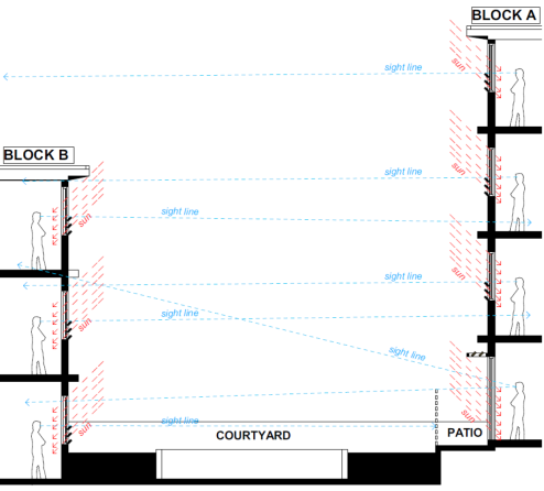
Figure 1: Detail of privacy louvre system proposed to the court yard facing windows
9. AESTHETICS
The requested change of the roof over the front part of the building facing Bunnerong Road from a pitched and lightweight metal roof to a flat concrete slab is not supported by the panel, as this impacts on the streetscape appearance of the development. The pitched roof should be retained, and details of the soffit and leading edge of the roof facing Bunnerong Road should be provided. Drainage details for this roof (guttering, downpipes, etc.) should also be supplied to ensure the aesthetics of the development are not compromised by services.
Planner’s comments
Agreed and a condition is included which requires the pitched roof to be retained as originally approved.
SUMMARY AND RECOMMENDATIONS
With the satisfaction of the amendments noted above particularly the maintenance solar access and privacy for 514-516 Bunnerong Road, the panel supports this Section 96 application.
4.4 Part D5 - Matraville Town Centre
Sub-section 3.2 - Building Envelopes
The Design Excellence Panel (DEP) has suggested that the built form and external space to the south western side of Building B facing Baird Lane be reduced so that is does not exceed the profiles of the existing boundary walls of the neighbouring development. The additional extension to the eastern side on the first and second floor levels to Building B are acceptable as they do not cause unacceptable amenity impacts or exceed the profiles of the existing southern boundary walls of the neighbouring development. However, the extension to the southern side of Building B on the third level will exceed the profile of the existing southern boundary wall of the neighbouring development which facing Baird Lane.
In the original consent the 4th storey level fronting Baird Lane (Building B) was supported on the grounds that is was limited in size and the built form was located to the northern side of the boundary which has a similar height profile and transitioned to a lower height profile to the southern side (which has a lower built form) to allow for greater solar access to the south facing building.
However, the proposed development does not support the intention and stated objectives in the DCP in that it will allow a greater built form to the southern side of the boundary which is much higher than the neighbouring residential building at no. 514 - 516 Bunnerong Road and does not transition into the allowable built form of 3 storeys. Despite the applicant increasing the setback to the south western corner of Building B to improve solar access and reduce privacy impacts, its presentation to the rear laneway and neighbouring property to the south will be visually dominant and will not be in keeping with the built form to the south of the site.
Additionally, the increased built form will reduce solar access and cause additional privacy concerns to the neighbouring residential units at no. 514 - 516 Bunnerong Road. Therefore, the increase in floor area to the third level is not supported and condition 3 which reads as follows shall remain:
f) Planter boxes having a minimum depth of 900mm with planting species that achieve a maximum height of 600mm at maturity are to be provided to the southern and eastern sides of the roof terrace deck to Block B which fronts on to Baird Lane.
The requested change of the roof over the front part of the building facing Bunnerong Road from a pitched and lightweight metal roof to a flat concrete slab is not supported by the DEP, as this impacts on the streetscape appearance of the development. It is therefore recommended that the pitched roof be retained as originally approved.
Therefore, the request to modify condition 2b to allow ventilated skylight on the new amended roof form at the top of the staircase/lobby for daylight and ventilation instead of the recessed slots as per the condition is not supported. Moreover, the ventilated roof skylight does not meet the intention of this condition which is to improve the internal amenity and to allow natural light and ventilation into the internal lobby areas of Building A.
Sub-section 7.1 - Natural Daylight, Overshadowing and Solar Access
The DCP details the following objectives in relation to Natural Daylight, Overshadowing and Solar Access:
· To optimise solar access to habitable rooms and to minimise the need for artificial lighting during daylight hours.
· To minimise the impact of overshadowing on the internal and outdoor areas of neighbouring buildings.
· To retain the amenity of the public domain by maximising solar access.
The controls require to:
i) Maintain sunlight access to private and public open spaces and north facing habitable rooms of adjoining development for at least 3 hours between 9am and 3pm on 21 June, where possible.
ii) Ensure that building layouts facilitate good solar access to both internal and external living spaces e.g. ideally locate living areas (including their associated balconies) to the north and east, and service areas to the south and west of the development.
iii) Maximise any northerly aspect and optimise the number of north facing windows. Shade north facing windows with roof eaves, verandahs or balconies, awnings or other horizontal shading devices.
iv) Provide adjustable shade devices suitable for lower sun angles (e.g louvres/blinds) to openings on the eastern and western facades.
v) Incorporate appropriately designed double glazed or energy efficient glass skylights and clerestory windows to improve daylight levels wherever possible.
vi) Do not use coloured/opaque glass as a shading device.
vii) Protect roof terraces with shade cloth, planting, pergolas and/or vergolas.
viii) Ensure that living spaces of at least 70% of apartments in any new development receive a minimum of 3 hours of sunlight between 9am and 3pm on 21 June, unless existing overshadowing prevents this.
The extension to Unit 11 on the third floor level to the southern side of Building B which facing Baird Lane will further reduce solar access into the neighbouring units at no. 514-516 Bunnerong Road and therefore, this part of the development is not supported.
The extensions to Units 3 & 7 on the first and second floor levels do not extend further than the rear profile of the existing boundary wall of the neighbouring development which faces Baird Lane and will not have a further negative impact on solar access to the neighbouing units directly adjacent to the site at no. 514-516 Bunnerong Road. This part of the development is supported as it will not have a negative visual, overshadowing or privacy impacts to the neighbouring units directly adjacent to the site or streetscape.
Sub-section 7.4 - Privacy - Visual
The DCP details the following objectives in relation to Privacy - Visual:
· To provide reasonable levels of visual privacy externally and internally, during the day and night.
· To maximise outlook and views from principal rooms and private open spaces without compromising visual privacy.
The controls require to:
i) Design building layouts to minimise direct overlooking of rooms and private open spaces by:
· separating communal open space, common areas and access routes from windows of rooms (particularly habitable rooms) changing the level between ground floor apartments (including their associated private open space) and the public domain or communal open space.
ii) Maximise visual privacy by providing the following minimum physical separations between buildings:
· Between habitable rooms -12 metres
· Between habitable room and balconies/non-habitable - 9 metres
· Between non-habitable rooms - 6 metres
iii) Increase privacy without compromising amenity by:
· offsetting windows of apartments in new development to windows in adjacent development;
· recessing balconies and/or providing vertical fins between adjacent balconies;
· using solid or semi-solid balustrades to balconies;
· using louvres or screen panels to windows and/or balconies;
· providing landscape screening;
· incorporating planter boxes into walls or balustrades to increase the visual separation between areas; and/or
· utilising pergolas or shading devices to limit overlooking of lower apartments or private open space.
The extended apartments to the eastern side of the western block (apartments 3 and 7) will maintain approximately 12m separation distance between the buildings.
Details have been provided in Figure 1 above demonstrating privacy levels will be maintained between the units and neighbouring properties whilst still maintaining adequate natural light into the rooms.
Despite the amended plans showing the extension to Building B on the third floor level to the south western corner of Unit 11 being setback approximately 2m off the southern side boundary, this will still have a negative impact on privacy to the neighbouring units at no. 514-516 Bunnerong Road and is one of the reasons it is recommended to be deleted from the approved plans.
7. Referrals
7.1 Development Engineers
A amended Section 96(2) application has been received which seeks to modify the approved development by adding a basement level car park with turntable, reconfiguration of car parking spaces, increase the size of the retail space at ground floor level, enclosure of balconies for units at first and second floors fronting Baird Lane, conversion of Units 3 and 7 to a 1 bedroom unit, increase the size of Unit 11 to 2 bedroom and changes to the roof design.
Original Consent:
Demolition of the existing commercial building and construction of a new part 4 part 5 mixed use shop top housing development comprising of 2 retail lots, 13 residential units and rear ground floor level carpark for 14 vehicles (variation to building height control).at the above site.
This report is based on the following plans and documentation:
· Statement of Environmental Effects by ABC Planning dated December 2016
· Architectural Plans stamped by Archi Spectrum dated 19th December 2016
PARKING PROVISION COMMENTS
Parking Requirements have been assessed adopting the parking rates specified in Part B7 of Council’s DCP 2013.
Section 96 proposal - Parking Provision - Residential
The amended proposal plans to convert 2 of the studios to a 1 bedroom units and another studio to a 2 bedroom unit. The total number of units will remain the same.
Apartment mix will therefore now comprise of 2 x studio + 6 x 1 bedroom + 5 x 2 bedroom units.
Parking Required = (2 x 0.5) + (6 x 1) + (5 x 1.2) + 13/4(visitor)
= 1.0 + 6 + 6 + 3.25(visitor)
= 16.25 spaces
Section 96 proposal – Parking provision - Commercial
The commercial component will now comprise of a single commercial tenancy with an increased floor area of 70.77m2 (52.86m2 previously approved).
Parking Required = 70.77/40
= 1.77 spaces
Total Parking Required = 16.25(Residential) + 1.77(Commercial)
= 18.02
= say 18 spaces
Total Parking Provided = 15 spaces
Parking Deficiency = 3 spaces (16.7%)
The parking deficiency will increase from 2 to 3 spaces as a result of the
Section 96 amendments and was not acknowledged or addressed in the Statement of
Environmental Effects. It is considered this this deficiency has now been
addressed by the provision of additional motorbike parking. Bicycle Parking has
already been conditioned in the original consent.
PARKING LAYOUT COMMENTS
The parking layout has been reconfigured to now provide two levels of basement parking. The lowest basement level is accessed via a ramp and turntable due to site constraints relating to the narrow width of the site. The previous issues raised have been satisfactorily addressed in the accompanying Carpark and compliance Report by Terrafiic Pty Ltd.
Aisle Width/carspace width
The car aisle width immediately adjacent to the carspaces is depicted on the submitted plans at less than the minimum 5.8m required under AS 2890.1:2004. The spaces are 2.6m wide being 200mm greater than the minimum 2.4m required in compensation for the reduced aisle width. Initial concerns were related to whether this would be enough for vehicle manoeuvrability
The accompanying carpark and access compliance report satisfactorily demonstrates that vehicles will be able to access the carspaces with the non-compliant aisle width. Two of the spaces have been designated small car only. This is permitted under the DCP and is satisfactory
Overhead Clearance
Concern was raised that the minimum overhead clearance could be achieved on the access driveway between the two parking levels. Upon further assessment on ramp grades and consideration of the accompanying carpark and access compliance report it is considered this can be achieved. This issue has therefore been satisfactorily addressed.
Disabled Space
The disabled space on the basement level has been relocated to ground floor level and is now satisfactory.
Geotechnical Comments
As a basement level has been proposed, conditions relating to the management of seepage/groundwater have been included in this consent. The site is also situated within a category Class 5 Acid Sulfate Soils area. Category 5 is not directly affected by Acid Sulfate Soils but places it within 400m of a Class 4 area. Any development must not result in the lowering of the water table within class 4. To ensure compliance the basement must comprise of a fully tanked structure.
Waste Management
The proposed bin room appears to comprise of larger waste bins than the standard 240L bin. Condition 24 will therefore need to be slightly amended.
8. Relationship to City Plan
The relationship with the City Plan is as follows:
Outcome 4: Excellence in urban design and development.
Direction 4a: Improved design and sustainability across all development.
9. Financial impact statement
There is no direct financial impact for this matter.
10. Conclusion
The proposed modifications to the existing development have been assessed against the requirements of the relevant planning guidelines of the RLEP 2012 and Council’s Randwick Comprehensive Development Control Plan, as well as in regard to Section 79C of the Environmental Planning and Assessment Act, 1979, as amended. The proposed modifications are considered to be substantially the same development as that previously approved.
The extension on the third floor level of Unit 11 and changes to the roof profile are not support in that they will cause amenity impacts to the neighbouring properties and streetscape.
Subject to conditions, the remaining modifications are considered to be acceptable and will not result in any significant adverse impacts upon either the amenity of the adjoining premises or the character of the locality.
|
A. That Council, as the consent authority, grants development consent under Section 96 of the Environmental Planning and Assessment Act 1979, as amended, to modify Development Consent No. DA/335/2015 by adding a basement level car park with turntable, reconfiguration of car parking spaces, increase the size of the retail space at ground floor level, enclosure of balconies for units at first and second floors fronting Baird Lane, conversion of Units 3 and 7 to a 1 bedroom unit, increase the size of Unit 11 to 2 bedroom and changes to the roof design at 512 Bunnerong Road, Matraville, subject to the following conditions:
· Amend Condition No. 1 to read: 1. The development must be implemented substantially in accordance with the plans and supporting documentation listed below and endorsed with Council’s approved stamp, except where amended by Council in red/or by other conditions of this consent:
Except, as amended by the Section 96 plans and documentation listed below, only in so far as they relate to the modifications highlighted on the Section 96 plans and detailed in the Section 96 application, except as may be amended by the following conditions and as may be shown in red on the attached plans:
B The following conditions are added:
· Amendment of Plans & Documentation 2. The approved plans and documents must be amended in accordance with the following requirements:
f) The proposed full height operable vertical louvers and full height glass windows to the balconies facing Baird Lane as detailed on drawings DA02 & DA03 (noted as Building B) on the first and second floor levels shall be amended in order for the balconies to remain 50% fully open. This will require two of the glass window panels to be deleted from each of the balconies.
Details are to be submitted for approval by Council’s Manager Development Assessments prior to issuing a construction certificate for the development.
g) The pitched roof form shall be retained as originally approved.
h) The extension to the southern side of Unit 11 shall be deleted from the approved plans.
i) An amended BASIX certificate shall be submitted to reflect the approved plans. Details are to be submitted for approval by Council’s Manager Development Assessments prior to issuing a construction certificate for the development.
· Condition 21A is added which is to be included in the construction Certificate
21A. The development must comply with the following requirements to ensure the adequate management of site seepage and sub-soil drainage and ensure that any water table is not lowered (Category 5 Acid Sulfate Soil area). :
a) Seepage/ground water and subsoil drainage (from planter boxes etc) must not be collected & discharged directly or indirectly to Council’s street gutter or underground drainage system;
NOTE: The system may be connected directly to Council’s underground drainage system (but only with the prior written approval of Council, as required under the Roads Act 1993) if it can be suitably demonstrated that there will be no lowering of the water table.
b) Adequate provision is to be made for any ground water to drain around the basement carpark (to ensure the basement will not dam or slow the movement of the ground water through the development site).
c) The walls of the basement level/s of the building are to be waterproofed/tanked to restrict the entry of any seepage water and subsoil drainage into the basement level/s of the building and the stormwater drainage system for the development.
d) Sub-soil drainage systems may discharge via infiltration subject to the hydraulic consultant/engineer being satisfied that the site and soil conditions are suitable and the seepage is able to be fully managed within the site, without causing a nuisance to any premises and ensuring that it does not drain or discharge (directly or indirectly) to the street gutter.
e) Details of the proposed stormwater drainage system including methods of tanking the basement levels and any sub-soil drainage systems (as applicable) must be prepared or approved by a suitably qualified and experienced Professional Engineer to the satisfaction of the Certifying Authority and details are to be included in the construction certificate. A copy of the proposed method for tanking the basement levels must be forwarded to Council if Council is not the Certifying Authority.
· Amend Condition 24.
24. The garbage room shall be sized to contain a total of 13 x 240 litre bins (comprising 7 garbage bins & 6 recycle bins) or equivalent storage with bins of different size and with adequate provisions for access to all bins. Details showing compliance are to be included in the construction certificate. Alternative bin sizes may be considered subject to the approval of the Waste Management Plan
· Condition 74A is added which is to be included prior to issue of an Occupation Certificate 74A. The applicant shall submit to the Principal Certifying Authority (PCA) and Council certification from a suitably qualified and experienced professional engineer, confirming that the walls of the basement have been fully tanked and waterproofed to prevent the entry of all groundwater in the basement level/s and that any required sub-soil drainage systems have been provided in accordance with the conditions of this consent. There must be no dry weather seepage/groundwater flows discharging to Council’s street gutter.
|
Nil
Planning Committee 14 November 2017
Development Application Report No. D91/17
Subject: 309-311 Bunnerong Road, Maroubra (DA/827/2008/B)
Folder No: DA/827/2008/B
Author: Jonathan Blackmore, Environmental Planning Officer
Proposal: Section 96 modification of approved development by addition of toilet to common roof garden and addition of toilet to roof garden of unit 10.
Original consent: Demolition of existing building and construction of a 4 storey mixed use development comprising 2 shops, 11 residential units and basement carparking for 13 vehicles
Ward: Central Ward
Applicant: Mrs V Koutras
Owner: Mrs V Koutras
Summary
Recommendation: Approval
|
|
|
|
Subject Site |
|
|
|
|
|
|
|
|
|
|
|
|
|
|
Submissions received
|
|
|
Ù North
|
|
|
Locality Plan |
Development Application Executive Summary Report
The applicant is referred to the Planning Committee for determination as the original approval was determined at a Council meeting.
Proposal
As the works have already been completed, the applicant is retrospective approval for the addition of toilet to common roof garden and addition of toilet to roof garden of unit 10.
The original consent involved demolition of existing building and construction of a 4 storey mixed use development comprising 2 shops, 11 residential units and basement car-parking for 13 vehicles.
Site
The subject site is located on the eastern side of Bunnerong Road, between Kingsford and Wild streets. The site has a B1 – Neighbourhood Centre zoning and is a part of a group of commercial and residential flat building developments on the block between Bunnerong Road and Wild Lane. Sites to the east of Wild Lane are predominately low density residential.
The subject site contains the completed 4 storey shop top housing development approved by the original consent.
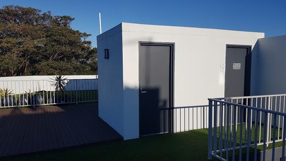
Figure 1. Photograph of a completed rooftop toilets to the common roof garden of the completed building (door to left of photograph).
Section 96 assessment:
Under the provisions of Section 96 of the Environmental Planning and Assessment Act, 1979, as amended, Council may only agree to a modification of an existing Development Consent if the following criteria has been complied with:-
Substantially the Same Development:
The modification to the approved development does not alter the nature of the approved development as it primarily involves two additional toilets over the existing approved building footprint. For the purposes of legislative requirements under Section 96 of the Environmental Planning and Assessment Act 1979, it is considered that the application remains substantially within the scope of the original development approval both qualitatively and quantitatively.
Submissions
The owners of adjoining and likely affected neighbouring properties were notified of the proposed development in accordance with the DCP – Public Notification. As a result of this notification, no submissions were received.
Section 79C Assessment
State Environment Planning Policy (Building Sustainability Index: BASIX) 2004.
A BASIX assessment is a mandatory component of the development approval process under the Environmental Planning and Assessment Amendment (Building Sustainability Index: BASIX) Regulation 2004 and State Environmental Planning Policy (Building Sustainability Index: BASIX) 2004.
Clause 55A of the EP & A Regulation requires that a new BASIX certificate be lodged for amended plans or where a section 96 modification makes a material change to the BASIX commitments as originally approved.
The proposed modification do not make a material change to the BASIX commitments. Standard conditions of consent requiring the continued compliance of the development with the SEPP:BASIX were included in the original determination.
Randwick Local Environmental Plan 2012
The following clauses of LEP 2012 are relevant to the proposed development:
Zone B1 – Neighbourhood Centre
The site is zoned B1 – Neighbourhood Centre under the RLEP 2012 and the proposal is permissible with Council's consent. The size and scale of the proposed development is compatible with the existing and desired future character of the locality and will not adversely impact on the amenity of adjoining properties or the character of the area.
Maximum Height – Clause 4.3 of the RLEP 2012
The site has a maximum height limit of 9.5m. The toilet to the roof garden of unit 10 adjoins the existing stairwell and matches its approved height of 15.12m above original ground level. The proposed toilet to the common roof garden also adjoins an existing stairwell and matches it existing height of 11.6m.
The additional non-compliances are not inconsistent with the relevant objectives of the RLEP 2012 and will not result in significant adverse impacts in terms of the amenity of neighbouring sites or the amenity and character of the area. The two toilets are relatively small additions over approved building footprint. The toilets do not increase the overall height of the building and their bulk is situated significant distances from the site’s boundaries. The external finishes and height of the toilets are the same as the stairwells that they adjoin and they therefore fit suitably into the context and are not generally noticeable to the casual observer. The toilets present no privacy issues for neighbouring sites and will not worsen shadowing for neighbouring sites due to their positioning on the approved building.
Floor Space Ratio – Clause 4.4 of the RLEP 2012
The two toilets will increase the floor space ratio. A floor space ratio of 1.75:1 was approved. The toilets add a total additional floor area of 4.4m2, taking the floor space ratio to 1.76:1. Clause 4.4 of the RLEP 2012 sets a maximum floor space of 1:1 for the site.
The proposed floor space ratio will not be inconsistent with the relevant objectives of clause 4.4 and the zone objectives of the RLEP 2012, and will result in no significant adverse impacts in terms of the residential amenity of adjoining sites and the character of the area. The scale and form of the development remains comparable to what was originally approved and to what exists on neighbouring sites within the block. The building’s footprint and overall height has not increased. The external finishes and height of the toilets are the same as the stairwells that they adjoin and they therefore fit suitably into the context and are not generally noticeable to the casual observer. The additional building bulk is set well back from the site’s boundaries and does not contribute to additional overshadowing or privacy loss for any neighbouring sites.
Development Control Plans
Wall Height – Sub-Section 3.2
The proposal does not increase the overall approved wall height. The additional lengths of wall resulting from the two toilets are not considered to be inconsistent with the relevant objectives of the RDCP 2013 and will result in no significant adverse impacts in terms of the residential amenity of neighbouring sites or the amenity and character of the area. As discussed previously, the two toilets are set well back from the site’s boundaries and are constructed over the existing building footprint. The additional bulk does not contribute to additional overshadowing or privacy loss for any neighbouring sites.
Other Environmental Impacts – Section 79C(1)(b)
The proposed modification will result in no significant adverse social, economic or environmental impacts. In particular, the proposed modification does not significantly extend the built form of the building, and the changes are generally contained within the existing footprint. Additional built bulk is set back sufficiently from side and rear boundaries. Privacy of adjoining sites will not be impacted, and no view loss is to occur.
Site Suitability
The modification to the approved development does not alter the nature or scale of the approved development in relation to site suitability.
Relationship to City Plan
The relationship with the City Plan is as follows:
Outcome 4: Excellence in urban design and development.
Direction 4a: Improved design and sustainability across all development.
Financial Impact Statement
There is no direct financial impact for this matter.
Conclusion
The proposed modification to the approved development has been assessed against the requirements of the relevant planning guidelines and Council policies and plans as well as in regard to Section 79C of the Environmental Planning and Assessment Act 1979, as amended. The proposed modifications are considered to result in a development that is substantially the same in nature as previously approved works. The modified development will not result in significant adverse environmental impacts upon the amenity and character of the locality.
Therefore, the application is recommended for approval.
|
That Council, as the consent authority, grants consent under Section 96 of the Environmental Planning and Assessment Act 1979, as amended, to modify Development Consent No. DA/827/2008/A for a Section 96 modification of the approved development by addition of toilet to common roof garden and addition of toilet to roof garden of unit 10.
The consent is modified in the following manner: · Amend Condition No. 1 to read: 1. The development must be implemented substantially in accordance with the plans numbered, DA01 to DA08 all Revision E, DA09 Revision D and DA10 Revision C, all dated March 2009, and stamped received by Council on 31 March 2009, the application form and any supporting information received with the application:
As amended by the Section 96 “B” plans and supporting documentation listed below:
Only in so far as they relate to the modifications highlighted on the Section 96 plans and detailed in the Section 96 application, except as may be amended by the following conditions and as may be shown in red on the attached plans:.”
|
Nil
Planning Committee 14 November 2017
Development Application Report No. D92/17
Subject: 185 Boyce Road, Maroubra (DA/847/2016/A)
Folder No: DA/847/2016/A
Author: Chahrazad Rahe, Senior Assessment Planner
Proposal: Section 96 modification of the approved development to delete condition 2(f) that requires deletion of the void areas at first floor level of both dual occupancies
Ward: Central Ward
Applicant: Mr G Lombardo
Owner: Boyce Group Pty Ltd
Summary
Recommendation: Approval
|
|
|
|
Subject Site |
|
|
|
|
|
|
|
|
|
|
|
|
|
|
Submissions received
|
|
|
Ù North
|
|
|
Locality Plan |
Development Application Executive summary report
The application is referred to the Planning Committee for determination at the request of Councilors Andrews, Seng and Stavrinos.
1. History & details of current approval:
On 22 February 2017 Council issued Development Consent under DA/847/2016 for demolition of the structures on site, Torrens title subdivision into 2 allotments, construction of 2 storey attached dual occupancy with garages front access from Galvin Street and construction of a 2 storey attached dual occupancy with semi-basement carparking and storage with access from Boyce Road and associated works.
As part of the consent Council supported a variation to Clause 4.4 of Randwick Local Environmental Plan 2012, relating to floor space ratio, however, the development was subject to a number of conditions, one in particular condition relates to deletion of the void areas at the first floor level of both dual occupancies which is the subject of this application. The condition reads as follows:
2(f) The void areas at the first floor level of both dual occupancies shall be deleted and roofs shall be designed within the void areas having a maximum height of 3.5m from the ground level. The void area above the roofs shall step in to be in line with the hallways of the dual occupancies. The Galvin Street dual occupancy voids shall be setback a minimum of 5m from the eastern and western side boundaries and the Boyce Road dual occupancy shall be setback a minimum of 4.2m from the eastern and western side boundaries. Any new glazing proposed in these parts of the development shall be incorporated into an amended BASIX certificate and submitted to Council for approval. Any new glazing shall incorporate external privacy screens to protect the privacy of the neighbouring buildings and rear yards opposite. The total area of any openings within the privacy screens must not exceed 25% of the area of the screens. Details showing compliance with this condition shall be submitted to Council for approval prior to a construction certificate being issued for the development.
2. Details of proposed modification:
The Section 96 modification application seeks to remove Condition 2(f) in order to permit the inclusion of the voids to the centre of the dwellings in both approved dual occupancies to allow solar access into the living areas.
3. Referrals:
No referrals are required for this application.
4. Section 96 Assessment:
Under the provisions of Section 96 of the Environmental Planning and Assessment Act, 1979, as amended, Council may only agree to a modification of an existing Development Consent if the following criteria has been complied with:-
4.1 Substantially the Same Development:
Section 96 of the Environmental Planning and Assessment Act 1979, states that a consent authority may, on application being made by the applicant or any other person entitled to act on a consent granted by the consent authority and subject to and in accordance with the regulations, modify the consent if:
(a) it is satisfied that the proposed modification is of minimal environmental impact, and
(b) it is satisfied that the development to which the consent as modified relates is substantially the same development as the development for which the consent was originally granted and before that consent as originally granted was modified (if at all), and
(c) it has notified the application
(d) it has considered any submissions made concerning the proposed modification within any period prescribed by the regulations or provided by the development control plan, as the case may be.
The proposed modifications seek to delete a condition imposed by Council which do not alter the nature or essence of the approved development and therefore, is considered to be substantially the same development as that for which the consent was originally granted.
4.2 Notification and Consideration of Submissions:
The owners of adjoining and likely affected neighbouring properties were notified of the proposed development in accordance with the Randwick Comprehensive DCP 2013. The following submission was received as a result of the notification process:
83 Cooper Street, Maroubra
|
Issue |
Comment |
|
Bulk and scale The proposed void areas, not only unnecessarily add to the bulk and scale of these dual occupancies, it is in effect additional ‘floor area’ in a development that already exceeds the allowable FSR Development Standard for this site.
This could potentially create a precedent for other Section 96 applications to convert the enclosed void areas as additional floor area to dual occupancy buildings. |
Refer to discussion on DCP requirements in Section 5.1.2 of this report.
|
5. Key Issues
5.1 Section 79C Assessment:
The site has been inspected and the application has been assessed having regard to Section 79C of the Environmental Planning and Assessment Act, 1979, as amended.
5.1.1 Environmental Planning Instruments
Randwick Local Environmental Plan 2012
The modified development is not inconsistent with the general aims and objectives of the RLEP 2012.
The following clauses of LEP 2012 are relevant to the proposed development:
Zone R2 – Low Density Residential
Subject to Condition 2 (f) being slightly altered, the proposed modifications to the approved development will continue to be consistent with the relevant objectives of the zone in that the change and additions are sympathetic to the existing built environment and will not result in unacceptable impacts on the amenity of neighbouring residents and the streetscape.
Clause 4.4 - Floor Space Ratio
There are no changes made to the FSR of the approved building.
Clause 4.3 - Height of Building
There are no changes made to the height of the approved building.
Development Control Plan – Part C1 Low Density Residential
Section 4 - Building Design
Sub-section 4.1 - General
Building envelope is defined by setbacks, building height, wall height and FSR. Façade treatment and detailing affect the visual presentation of buildings and play a pivotal role in either enhancing the character, continuity of streetscapes and visual amenity of neighbouring properties.
One of the key objectives of the DCP under matters relating to the building design is to ensure building facades are articulated to complement or enhance the existing streetscape and neighbourhood character. The additional void area to both of the dual occupancies unnecessarily adds mass to the façade composition along the side elevations thereby not meeting the objectives of the control. The building could potentially be modified in the future to provide additional floor area to the dwellings which will result in a further non-compliance to the FSR standard in the LEP of the approved development. This also results in unnecessary impacts on the perceivable bulk and scale of the buildings and significantly detracts from the visual amenity of the neighbouring properties.
The DCP control for design measures for modelling and articulating a building requires the side elevations of the walls to be divided into sections, bays or modules of not more than 12m in length, separated by measures, such as recesses or side courtyards, in order to avoid massive or unrelieved walls. The proposed dual occupancies do not meet this control and extend for a length of 16.625m (for the dwellings facing Boyce Road) and 15.826m (for the dwellings facing Galvin Street).
Under the original assessment Council raised concerns with the applicant that the physical enclosure of voids with masonry and window openings did not represent genuine void areas for the purposes of both maximising light and ventilation to the dual occupancies and ensure adequate articulation. The following assessment was concluded:
The legitimacy of the void areas was challenged in that whilst the voids provide a greater sense of internal space; they don’t maximise light and ventilation to the dwellings and the long unrelieved walls along the side elevations are contrary to key building design objectives and controls under Part C1 of the Randwick Development Control Plan (RDCP) 2013 which seek to provide adequate levels of modulation and articulation by stepping in the building along the side elevations. This is not fatal to the application in that a condition may be included requiring the walls and openings associated with the voids to be stepped further in along the side elevations at first floor levels with a higher ceiling over ground level. Such a condition will improve light and ventilation, reduce mass and introduce articulation that provides visual interest inclusive of the sense of internal space.
The assessment by the previous planning officer is therefore supported. By lowering the wall height of the void areas to the centre of the building the massing of the side walls will be reduced. The visual amenity and articulation along the side elevations as viewed from the neighbouring properties will also be improved. However, there is opportunity to increase the wall height by 500mm to 4m (from the ground level) to improve solar access and ventilation into the living areas throughout both dual occupancies as requested as part of this application whilst still meeting the control objectives of the DCP. The additional wall height of 500mm will still achieve articulation to the side of the walls and does not unreasonably impact on the visual amenity of the neighbouring properties.
In order to articulate the external facades and reduce the apparent mass of the buildings, condition 2 (f) shall be slightly altered to read as follows:
2 (f) The void areas at the first floor level of both dual occupancies shall be deleted and roofs shall be designed within the void areas having a maximum height of 4m from the ground level. The void area above the roofs shall step in to be in line with the hallways of the dual occupancies. The Galvin Street dual occupancy voids shall be setback a minimum of 5m from the eastern and western side boundaries and the Boyce Road dual occupancy shall be setback a minimum of 4.2m from the eastern and western side boundaries. Any new glazing proposed in these parts of the development shall be incorporated into an amended BASIX certificate and submitted to Council for approval. Any new glazing shall incorporate external privacy screens to protect the privacy of the neighbouring buildings and rear yards opposite. The total area of any openings within the privacy screens must not exceed 25% of the area of the screens. Details showing compliance with this condition shall be submitted to Council for approval prior to a construction certificate being issued for the development.
Relationship to City Plan
The relationship with the City Plan is as follows:
Outcome 4: Excellence in urban design and development.
Direction 4a: Improved design and sustainability across all development.
Financial impact statement
There is no direct financial impact for this matter.
Conclusion
The proposed modifications to the existing development have been assessed against the requirements of the relevant planning guidelines of the RLEP 2012 and Council’s Randwick Comprehensive Development Control Plan, as well as in regard to Section 79C of the Environmental Planning and Assessment Act, 1979, as amended. The proposed modifications are considered to be substantially the same development as that previously approved.
The request to retain the void areas in both approved dual occupancies are not supported. However, Condition 2 (f) has been slightly modified to allow for more solar access and ventilation into the living areas of both dual occupancies.
|
That Council, as the consent authority, grants development consent under Section 96 of the Environmental Planning and Assessment Act 1979, as amended, to modify Development Consent No. DA/847/2016/A for permission to delete condition 2(f) that requires deletion of the void areas at first floor level of both dual occupancies for 185 Boyce Road, Maroubra in the following manner:
Non standard conditions Amend Condition 2 (f) to read as follows: f. The void areas at the first floor level of both dual occupancies shall be deleted and the roofs shall be designed within void areas having a maximum height of 4m from the ground level. The void area above the roofs shall step in to be in line with the hallways of the dual occupancies. The Galvin Street dual occupancy voids shall be setback a minimum of 5m from the eastern and western side boundaries and the Boyce Road dual occupancy shall be setback a minimum of 4.2m from the eastern and western side boundaries. Any new glazing proposed in these parts of the development shall be incorporated into an amended BASIX certificate and submitted to Council for approval. Any new glazing shall incorporate external privacy screens to protect the privacy of the neighbouring buildings and rear yards opposite. The total area of any openings within the privacy screens must not exceed 25% of the area of the screens. Details showing compliance with this condition shall be submitted to Council for approval prior to a construction certificate being issued for the development.
|
Nil
Planning Committee 14 November 2017
Development Application Report No. D93/17
Subject: 15 Stewart Street, Randwick (DA/594/2017)
Folder No: DA/594/2017
Author: Yvette Middleton , Planning Consultant - APP Corporation Pty Ltd
Proposal: Ground and first floor alterations and additions to the existing dwelling (Heritage Conservation Area).
Ward: East Ward
Applicant: Mr J Spiteri
Owner: Ms N S Soltyszewski &Mr S L Wright
Summary
Recommendation: Approval
|
|
|
|
Subject Site |
|
|
|
|
|
|
|
|
|
|
|
|
|
|
Submissions received
|
|
|
Ù North
|
|
|
Locality Plan |
Development Application Executive summary report
The application is referred to the Planning Committee for determination as one of the property owners is a Randwick City Council employee.
Proposal
The proposal seeks approval for alterations and additions to an existing two-storey semi-detached dwelling at No. 15 Stewart Street, Randwick. The proposal includes:
· Internal alterations to the configuration of the existing ground floor level to accommodate a new bathroom, an open plan kitchen with living and dining areas; and
· Construction of a new extension to the rear of the existing first floor level to accommodate two bedrooms and a bathroom.
The proposal does not include changes to the existing building footprint, site coverage, fencing or landscaping.
Site and Surrounds
The subject site is located on the northern side of Stewart Street, with the detached garage facing Nancye Street at the rear.
The site has a street frontage of 6.915m, a lot depth of 38.1m and a total site area of 265m2. The land slopes approximately a metre from the northern rear boundary to the southern front boundary. There is a small cross-fall from west to east. It is legally described as Lot B in Deposited Plan (DP) 326090.
The subject site is one of a pair of semi-detached dwellings with No. 13 Stewart Street. On the eastern side is No. 17 Stewart Street, Randwick. The subject dwelling is partially one and two storeys. The adjoining and adjacent semis are single storey. Both the subject site and No. 17 have garages to the rear boundary.
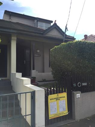
Figure 2: Front of existing dwelling house, as viewed from Stewart Street.
Nearby Development
The immediate locality is characteristic by predominantly one and two storey semi-detached dwellings and nearby multi storey residential flat buildings.
To the north-west of the site is the Randwick town centre, Prince of Wales Hospital and Sydney Children’s Hospital.
Further to the west is a two-storey dwelling currently under construction (pictured below)
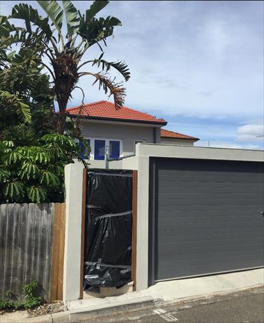
Figure 3: Surrounding development at 7 Stewart Street, viewed from Nancye Street.
Submissions
The owners of adjoining and likely affected neighbouring properties were notified of the proposed development in accordance with the Randwick Comprehensive DCP. As a result of this notification, the following submission was received:
Jennifer Grimson – 13 Stewart Street, Randwick
|
Issue |
Comment |
|
Concerned that her neighbouring property will be damaged during construction. |
The objector is unaware of the proposed building methods to be employed in the proposed alterations and additions. Therefore, requests that Council imposes a condition that requires a ‘Dilapidation Report’ be undertaken prior to the commencement of any building works, to establish the pre-existing condition of the properties.
This has been imposed as an approval condition. |
Key Issues and areas of non-compliance:
|
Key Issue |
Comment |
|
Visual Privacy |
The existing building features windows on the eastern side of the dwelling, facing 17 Stewart Street, Randwick. To minimise visual privacy impacts, the proposal has included a minimum sill height of 1600mm above finished floor level for ground floor windows to the living area, other than a kitchen bench level window. The kitchen bench level window will be below the boundary fence height.
New upper floor windows are to a bathroom and bedroom on the side elevation. The primary bedroom windows face the rear, and the location of the secondary window is unlikely to cause loss of privacy. The new rear facing windows are a similar form to existing rear-facing windows on the existing upper floor. |
|
Sunlight |
The proposed shadow diagrams indicate the required levels of solar access will be provided. |
|
Heritage |
The site is located within The Spot Heritage Conservation Area under Schedule 5 of the LEP.
Heritage comments have been provided by Council’s Heritage Planner, and are included in the Compliance report.
The comments conclude the proposal is unlikely to have any significant impacts on the significance of The Spot Heritage Conservation Area.
The Heritage planner recommends inclusion of the following condition: Colours, materials and finishes of the external surfaces to the building are to be compatible with the existing building and adjacent dwellings in the terraced row and consistent with the architectural style of the building. Details of the proposed colours, materials and textures (ie- a schedule and brochure/s or sample board) are to be submitted to and approved by Council’s Director City Planning, in accordance with Section 80A (2) of the Environmental Planning and Assessment Act 1979 prior to a construction certificate being issued for the development.
This has been included as a non-standard condition. |
Relationship to City Plan
The relationship with the City Plan is as follows:
Outcome 4: Excellence in urban design and development.
Direction 4a: Improved design and sustainability across all development.
Financial impact statement
There is no direct financial impact for this matter.
Conclusion
The proposal complies with the relevant assessment criteria and will not result in any adverse impacts upon either the amenity of the adjoining premises or the character of the locality.
The application is therefore recommended for approval subject to the attached conditions of consent.
|
That Council, as the consent authority, grants development consent under Sections 80 and 80A of the Environmental Planning and Assessment Act 1979, as amended, to Development Application No. 594/2017 for 15 Stewart Street, Randwick, subject to the following non standard conditions and the standard conditions contained in the development application compliance report attached to this report:
· Non-Standard Condition Amendment of Plans & Documentation 2. The approved plans and Documents must be amended in accordance with the following requirements:
a. Colours, materials and finishes of the external surfaces to the building are to be compatible with the existing building and adjacent dwellings in the terraced row and consistent with the architectural style of the building.
Details of the proposed colours, materials and textures (i.e. a schedule and brochure/s or sample board) are to be submitted to and approved by Council’s Director City Planning, in accordance with Section 80A (2) of the Environmental Planning and Assessment Act 1979, prior to a construction certificate being issued for the development.
|
|
1.⇨ |
DA Compliance Report - 15 Stewart Street, RANDWICK |
Included under separate cover |
Planning Committee 14 November 2017
Development Application Report No. D94/17
Subject: SECPP - (Lots A & B in DP 330407) 29-39 Young Street, RANDWICK (DA/370/2017)
Folder No: DA/370/2017
Author: Willana Associates, Pty Ltd
Introduction
The subject application is reported to the Planning Committee Meeting as it is classified as a “regional development” (having a capital investment value in excess of $20 million) and is required to be determined by the Sydney Central Planning Panel (SCCP) pursuant to Schedule 4A, of the Environmental Planning and Assessment Act 1979 and Part 4 of State Environmental Planning Policy (State and Regional Development) 2011. The purpose of this report is to allow Council to consider the assessment report prepared in relation to the application and to determine whether to make a submission to the Sydney Eastern City Planning Panel (SECPP).
The application is seeking consent for demolition of some existing structures and construction of four (4) buildings of varying heights from three (3) to seven (7) storeys situated on Lots E3 and E4 located along the eastern precinct of the larger Newmarket site. The proposal is summarised below and includes the following works and features;
· Demolition of the existing buildings and associated structures;
· Excavation, remediation and site preparation works;
· Lot E3: Construction of three residential flat buildings with the following characteristics;
- Building E3.1, a 5 storey building containing 30 apartments;
- Building E3.2, a 7 storey building containing 44 apartments;
- Building E3.3, a 7 storey building containing 73 apartments.
· Lot E4: Construction of one residential flat building with the following characteristics;
- Building E4.1, a 3-storey building containing 18 apartments.
· Two levels of basement car parking with direct access off Young Street containing a total of 175 resident car parking, 17 visitor spaces, 10 motorcycle spaces and capacity for 165 bicycle spaces.
· Retention and preservation of three (3) significant Morton Bay Fig Trees.
· A large central landscaped plaza located between buildings E3.1, E3.2 and E3.3 which includes a water feature, communal seating and associated landscaping features including retaining walls and fencing.
Figure 1 below, provides an aerial view of the subject Site and its curtilage in relation to the locality in which it is located and Figure 2 indicates the proposed building lots within the broader Newmarket Green site and site areas of each lot.
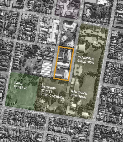
Figure 1: The location of the subject Site (Lots E3 and E4 highlighted)
within the wider locality (courtesy smart design studio)
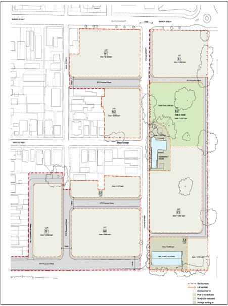
Figure 2: Configurations and associated site areas of the lots
within the Newmarket Green site (courtesy smart design studio)
Site
The subject Site is known as 29-39 Young Street, Randwick and is legally described as Lot A and B in DP 330407, also referred to as Lots E3 and E4. The Site is known as the ‘Eastern Precinct” within the larger Newmarket Site.
The survey plan prepared by Lockley Surveyors and dated 6 May 2015, defined this part of the wider Newmarket site as ‘Site A’. ‘Site A’ is a regular, rectangular shaped allotment bounded by Barker Street to the north, Young Street to the west, Randwick Girls High School to the east and Rainbow Street Public School to the south and southwest. It has a total site area of 2.343ha however this also includes Lot E1 and the area dedicated to become the public park. The actual area of the subject development site is smaller when only considering the area of Lots E3 and E4. Lots E3 and E4 have a combined site area of 7,816sqm.
![]()
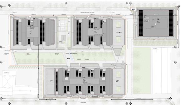
Figure 3: Site plan showing the location and footprints of the new buildings and the landscaped area around the buildings (courtesy smart design studio)
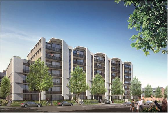
Figure 4: Western elevation of Building 3.3 facing Young Street (courtesy smart design studio).
Issues
Staged DA Consent
The DA is for a subsequent stage of the Concept Plan approval for a Staged DA (88/2016) that provided for a mixed use development on the subject site comprising the following:
· Site preparation including demolition of structures, removal of vegetation and excavation.
· Road infrastructure and public domain conceptual layout.
· Subdivision into 9 development lots and one public open space lot.
· Four new public streets intersecting from Young, Jane and Botany Street.
· A set of built form controls (dwelling types, storeys, heights, setbacks and landscape areas) that will guide the form and character of buildings to be erected on the site.
· 19 buildings which range from 2 to 8 storeys with an indicative number of 650-750 residential dwellings, retail and commercial uses including an urban plaza.
· Provision of parking at the basement level in addition to on-street parking across the site.
· Adaptive re-use of the Newmarket House and the Big Stable Building.
· Site remediation and earthworks.
The Concept Plan approval also includes a new 5,006sqm public park within the eastern precinct which is consistent in its location with Section 3.4: Open Space Network and Landscaping of the Newmarket Green Development Control Plan (DCP). This is located immediately to the north of the subject Site.
New roads and associated infrastructure would also be dedicated to Council as part of the subdivision. The Newmarket site is subject to a Voluntary Planning Agreement which provides a 1.5% contribution of affordable housing, the transfer of the Big Stable and its curtilage to Council (including a monetary contribution to its maintenance), dedication of a public park and roads, as well as a contribution towards traffic calming. The proposal is consistent with the terms of the VPA.
Development Consent for DA No.662/2016 was issued on 8 August 2017 which approved a series of remediation and infrastructure works, including new roads, provision of the public park and demolition of existing stable buildings.
On 17 August 2017 the Sydney Central Planning Panel approved DA No.664/2017 which included the demolition of existing structures and construction of a 2 x 8 storey shop top housing development within Lots E1.1 and E1.2, including ground floor commercial tenancies, 133 apartments, basement car parking and the incorporation of an 18m wide urban plaza that provides a connection from Barker Street through the site to the south of this precinct.
The proposed development is consistent with the terms of approval of the Concept plan and any relevant works approved under Development Consent for DA No.662/2016. (Also refer to sections below with regard height, gross floor area, landscaping and heritage conservation).
Public exhibition
The development application was subject to a public exhibition, an advertisement within the local newspaper and site notification attached to the subject premises as per the requirements of the Randwick Development Control Plan 2013 (RDCP2013) for Public Notification. Three (3) submissions were received in response to the public exhibition raising issues with the density, size and scale of buildings and their impact on Rainbow Public School, traffic & parking, as well the loss of amenity for neighbouring residents.
The matters raised in the submissions are addressed in the attached detailed assessment report which concludes that the proposal is a high quality urban design outcome for the Site, the amenity impacts are reasonable and minimised by the sensitive and clever architectural solution and the proposal complies with the building envelope outcomes anticipated by the Masterplan.
Urban Design
The application was referred on two occasions to the Design Review Panel (DRP) as per the requirements of State Environmental Planning Policy 65: Design Quality for Residential Apartment Development. The DRP raised a few concerns with the initial design (prelodgement stage) which was reviewed on 1 May 2017. The Panel had issues with the aesthetics of the proposal and requested further modulation to some facades to improve their relationship with adjoining buildings, Building E4.1 to adopt a greater design resolution and a more detailed landscape plan to ensure the design expresses clear through links to Barker Street and communal areas of open space are designed so that they will assist in activating this part of the precinct.
The design was amended and refined further taking into consideration the Panel’s comments. The current design was referred to the Panel for a further review on the 3 July 2017. In conclusion the DRP were satisfied with the design resolution for the Site and stated that “The panel is supportive of this proposal, and does not need to review it again. We are in agreement that the applicant is to be commended for the clarity and sophistication of the architectural outcomes”.
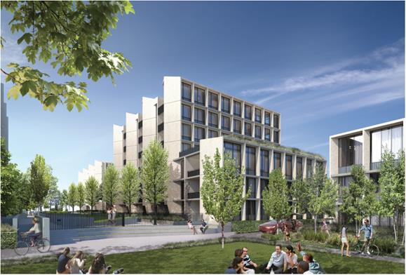
Figure 5: Southern elevation of Building E3.2 when viewed from the area of open space in front of the Big Stable Building (courtesy smart design studio).
Figures 4, 5 and 6 provide some 3D perspectives of the intended façade treatment, architectural representation and articulation of the buildings when viewed from the southern part of the Site.
Despite the DRP’s support of the proposed scheme a detailed assessment against the main design principles and performance controls (cross ventilation, landscaping, solar access, overshadowing, apartment mix and size) in respect to the Apartment Design Guide (ADG) has been undertaken. It concludes that the proposal satisfies the key controls and provisions of the ADG and the development will ensure that a high level of internal amenity is achieved.
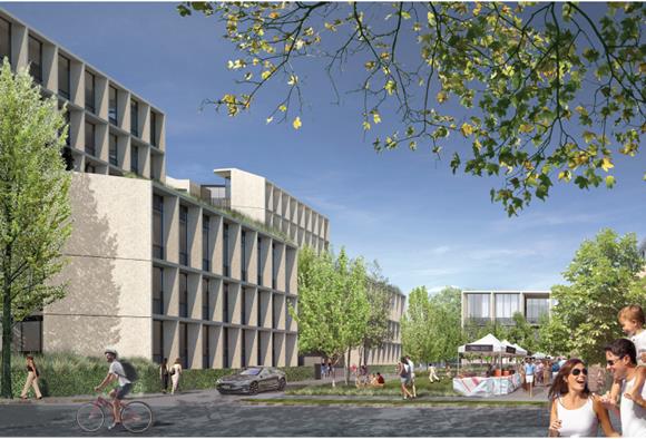
Figure 6: Perspective looking east from Young Street taken from across the road from the Big Stable Building (courtesy smart design studio)
Landscaping
Three (3) significant existing Moreton Bay Fig Trees are intended to be retained and integrated as part of the development. These trees are important elements and features of the landscaping scheme (refer to Figure 8). Figure 7 below highlights the three trees (T16, T37 and T22) that are to be retained and their current location.
The trees are located along the eastern side of the Site and located near Building’s E3.1 and E3.2. An arborists report was prepared by Tree IQ and dated 6 June 2017 and analysed the extent of the proposed works on these trees and their impact.
In summary the report recorded the following findings:
“The supplied Deep Soil &TPZ Plan (dated 4.11.16, Rev 2, prepared by SJB) shows that the proposed E3 Building footprint encroaches into the Tree Protection Zone (TPZ) of Trees 16, 22 and 37. The extent of the encroachments has been calculated as 32.4%, 1.4% and 22.3% respectively. As the encroachment into the TPZ of Tree 22 is less than 10% of the TPZ, the extent of work represents a Minor Encroachment as defined by AS-4970. A Minor Encroachment is considered acceptable by AS-4970 b when it is compensated for elsewhere and contiguous within the TPZ. The encroachments into the TPZ areas of Trees 16 and 37 are greater than 10% and represent Major Encroachments as defined by AS-4970. Clause 3.3.4 of AS-4970 provides for undertaking works within a TPZ when root investigations indicate the works will not significantly impact the tree’s health, stability, or long term viability. Root investigations were undertaken along the proposed line of excavation within each TPZ to determine the impacts of development on the trees. Three (3) trenches were excavated on the 21st of September 2016.”
The report concluded that “Based on the root mapping results, the construction of Buildings E3 and E4 should not have a significant impact on the health of Trees 16 and 37. No over-excavation, battering or benching beyond the footprint of proposed structures should be undertaken.”
Pruning that is required to trees 22 and 37 to cater for the buildings will be in the order of 5% and should be no greater than 10% of the tree’s total crown volume for Tree 37. The arborists report recommended that a Tree Protection Specification and Tree Protection Plan be prepared prior to the commencement of works on site. This will be included as conditions on the consent.
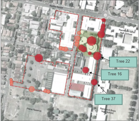
Figure 7: Location of trees to be retained, T16, T22, T37 (courtesy Urbis, 2017)
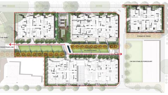
Figure 8: Landscape Plan – landscaping features and proposed treatment in relation to the proposed new buildings (courtesy smart design studio)
Height, bulk and scale
In general the proposal complies with the building envelope controls that were established by the Concept Plan approval. The heights of the new buildings slightly exceed the anticipated masterplan outcomes however they are satisfactory particularly given the following:
· They comply with the maximum height limits of 12m and 25m established for the Site in accordance with Clause 4.3 of the Randwick Local Environmental Plan, 2012 (RLEP).
· The Joint Randwick/Waverley Design Review Panel did not raise any concerns
· The proposed development will result in a superior design and built form outcome.
· The variance will not result in any significant amenity impacts.
· The variances are minor and relate to minor structures. They do not alter the built form (footprint or general envelope) so that it is inconsistent with the Concept Plan outcomes.
· The building footprints and overall building envelopes envisaged by the Concept Plan are maintained.
Also in respect to the number of storeys reflected for each building, the design is consistent with the Concept Plan heights that were contemplated for the future built forms (refer to Figure 16 below). Therefore the buildings design, layout and overall form is consistent with the future desired character for this part of the Site.
The proposed gross floor area for Buildings E3.1, 3.2, 3.3 and E4.1 has been designed to comply with the 1.3:1 maximum FSR across the whole site in accordance with the commitments that are to be achieved pursuant to the Concept Plan and Clauses 4.4 and 6.16 of the RLEP. The whole Newmarket site has a total site area of 50,634sqm and the FSR permits a total gross floor area of 65,824sqm. The subject Site (Lots E3 and E4) comprise of an area of 7,816sqm. The gross floor area proposed for this section of the site is 17,554sqm. This represents an FSR of 2.2:1 which is appropriate in this case. This section of the Site is more isolated and separated from the lower scale residential developments to the west and other land uses (adjoining schools) therefore it can cater for some greater intensity of residential development as impacts are mitigated and there is greater separation between buildings and adjoining uses.
The gross floor area for the whole site has been distributed in a way to ensure that the scale, form and intensity of new development across the site is respectful and sympathetic to the character of development in the streetscape, adjoining land uses and locality. Table 1 below provides a breakdown of the gross floor area (GFA) across the whole site and confirms that the proposed development is consistent with the Concept Plan and RLEP anticipated floor space distribution across the whole site.
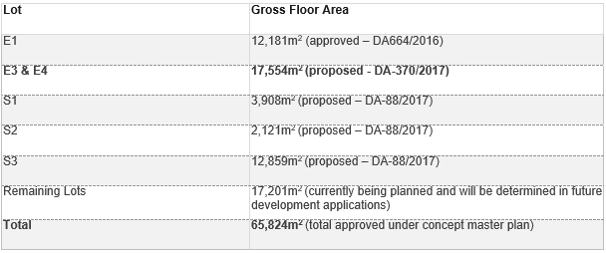
Table 1: Gross Floor Area summary and distribution across the Site (courtesy Urbis P/L, June 2017)
Heritage
The Concept Plan contains three (3) Heritage Items of Local and/or State significance. Table 2 below outlines the three (3) items and defines their importance. Figure 9 is an aerial showing two heritage items that are located within the development whole site.
|
Address
|
Heritage Item |
Inventory Number |
Significance |
|
164-174 Barker Street Lot A, DP 330407
|
Newmarket House |
I466 |
Local |
|
164-174 Barker Street Lot A, DP 330407
|
Newmarket Sales Ring |
I292 |
Local |
|
29-39 Young Street Lot B, DP 330407
|
Big Stable Newmarket |
I458 |
State |
Table 2: List of Heritage Items and their significance
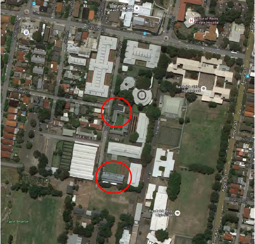
Figure 9: Aerial photo of the two Heritage Items within the development site (courtesy OCP Architects, September 2016)
The subject Site comprising of Lots E3 and E4 contains two of the items noted above, the Big Stable Newmarket Building and Newmarket House. These items are to be preserved and retained and no works are proposed to them under this application. So in assessing the proposed development it is important to consider the siting and impact of the proposal onto these properties and ensure their integrity, significance and general setting is maintained and enhanced.
The Newmarket Sales Ring sits within that part of the whole site that has been designated as a public park (immediately to the north of the subject site) and has been sympathetically integrated into the parkland (essentially its treatment has been determined by DA approval 662/2016).
Photo 1: Big Stable Newmarket Building, Item of State significance (courtesy smart design studio)
Photo 2: Front elevation and main entry to Newmarket House, item of local significance (courtesy smart design studio)
Photo 3: Eastern elevation of Newmarket House (left) and the Newmarket Sales Ring (centre/right) which will be retained and incorporated as part of the Public Park.
The subject site also adjoins the Struggletown Conservation Area designated as C19 in Schedule 5 of the RLEP.
In accordance with Clause 5.10 (Heritage Conservation) of the RLEP, consideration of the development on the heritage significance and setting of these items needs to assessed. The application was referred to Council’s Heritage Officer who provided a very detailed assessment of the proposal (included in the attached report). In principle no objection was raised in respect to the proposed bulk, scale, setbacks, architectural form and design and overall design intent of the development as it generally satisfies the building envelope and footprint outcomes that were resolved by the Concept Plan for the whole site.
However one issue that was raised concerned the removal of two round yards that form part of this application. The referral stated that “There are concerns that the removal of the two round yards (the southern round yard as part of the current application) will forgo the opportunity to either retain in situ or dismantle and reconstruct these structures, which may lend themselves for use as shade structures either within the public park or adjacent to the Big Stable, and which have important interpretative value”. It is recommended that conditions be included in a consent to retain these structures in some form or integrate them in another part of the site which would to a large degree retain their historical importance in a physical form.
The proposed development is classed as Integrated Development in accordance with Section 91 of the Environmental Planning and Assessment Act, 1979 as the proposed development is located on land where an Item of State Significance (Big Stable Newmarket Building) is sited. The application has been referred to the NSW Heritage Office for their comment and concurrence has been granted in accordance with the EP and A Act and Heritage Act, 1977 requirements.
Relationship to City Plan
The relationship with the City Plan is as follows:
Outcome: A vibrant and diverse community, leadership in sustainability, excellence in urban design and development, integrated transport and land use.
Direction: Improved design and sustainability across all development, integrating transport and pedestrian links between town centres and key locations.
Financial impact statement
The Concept Plan approval (Staged DA 88/2016) is subject to a VPA that will provide Council with a range of community assets that will require ongoing expenditure and future budget allocations. The proposed development is not contrary to the terms of the VPA.
Conclusion
The proposed development satisfies the relevant statutory assessment criteria and will result a built form and spatial relationship with the public domain that will become an exemplary addition to the urban fabric. As such, the application is recommended for approval.
|
That the SECPP assessment report for DA/370/2017, (Lots A & B in DP 330407) 29-39 Young Street, RANDWICK be received and noted. |
|
1.⇩ |
Sydney Central Planning Panel Report - DA/370/2017 (Lots A & B in DP 330407) 29-39 Young Street, RANDWICK |
|