
MINUTES OF Traffic Committee MEETING
HELD AS A TEAMS MEETING
ON Tuesday, 11 May 2021 AT 9:30am
Traffic Committee
- The following information is provided so that you may be aware of the structure and operation of the Randwick City Traffic Committee.
- The Randwick Traffic Committee is a Committee of Randwick City Council but not one set up under the Local Government Act.
- Council has been delegated certain powers from Transport for NSW (TfNSW), with regard to traffic matters upon its local roads. A condition of this delegation is that Council must take into account the Traffic Committee recommendations.
- Recommendations in this document may either activate the formal delegation from Transport for NSW to the Council, or not activate this delegation. Items which activate the delegation are indicated with the initials (AD) below the heading.
- There are four permanent members of the Traffic Committee, each of whom has a single vote only.
- The members are: the NSW Police Service, Transport for NSW, the Local State Member of Parliament (for the location of the issue to be voted upon) and Randwick City Council.
- Randwick City Council welcomes the public to register to speak at its Traffic Committee on issues of concern.
- If the Local Member disagrees with any of the Traffic Committee recommendations, they may appeal to Transport for NSW or the Minister for Roads.
- If the Police or Transport for NSW disagrees with any of the Traffic Committee recommendations, or Council’s resolution on any Traffic Committee recommendation, they may lodge an appeal with the Sydney Regional Traffic Committee for determination. The appeal must be lodged in writing within 14 days of the notification to the members of Council’s decision on the recommendation.
- Any action relative to any issue under appeal must cease until the matter is determined.
- The Sydney Regional Traffic Committee is chaired by an independent chairperson and submissions and representations are welcomed from all interested parties.
Acknowledgement of Country
Jai Sue volunteered to acknowledge the lands upon which this meeting is being held:
“I would like to acknowledge that we are meeting on the land of the Bidjigal and the Gadigal peoples; being the traditional owners who, for thousands of years, occupied and cared for vast areas along the Sydney Coast.
On behalf of the participants of this meeting I acknowledge and pay my respects to the Elders past, present and emerging, and also to those Aboriginal people participating today.”
Participants:
Mr Tony Lehmann Randwick City Council (Chairperson)
Mr Steven Nguyen Transport for NSW (TfNSW)
Cr Dylan Parker Representative for Member for Maroubra and Member for Coogee (part of the meeting)
Cr Lindsay Shurey Councillor Delegate for Traffic Committee
Cr Kathy Neilson North Ward
Mr Bushara Gidiess State Transit Authority
Mr Anthony Ryan Resident
Mr Paul Chilcott Resident
Mr Shannon Murphy UNSW
Mr Alexander Lin, Ms Despina Kalavas (part meeting), Ms Lauren Bonomini, Ms Nafisa Nishandar, Mr Billy Samonte & Ms Jai Sue - RCC
Apologies
|
|
Apologies were received from: · Eastern Beaches Police · Representative for the Member for Heffron
|
Pecuniary interest declarations
a. Resident Anthony Ryan declared a non-pecuniary interest regarding Item TC75/21.4 Howard Street, Randwick, within the Traffic Committee Report Federal Stimulus Road Safety Program School Zones project table, as he is a friend of Ms Gibbs who instigated this matter.
b. Chairman Tony Lehmann declared a non-pecuniary interest regarding Item TC189/20 Prince Of Wales Hospitals, Randwick - Covid-19 Special Temporary Parking Permits as he has a close relative who may benefit from the outcome of this item.
Matters Arising from the Minutes OR from Council Resolution
Nil.
Traffic Committee Reports
TC75/21 Federal Stimulus Road Safety Program Zones Projects (C, H & M)............................................ 3
TC76/21 Neptune Street and Beach Street, Coogee - 4 Hour Time Limited Parking Survey (C)................ 5
TC77/21 Prince of Wales Hospitals, Randwick - Covid-19 Special Temporary Parking Permits - various streets (C)......................................................... 7
TC78/21 High Street, Randwick - between Anzac Parade and Wansey Road (H)........................................ 8
TC79/21 Anzac Parade, near Bilga Crescent, Malabar (M). 9
TC80/21 Minor Signage Items - Parking and Regulatory - May 2021 (C & M).............................................. 9
TC81/21 Works Zone - Installation and Removal of Signage - May 2021 (C, H & M)..................................... 11
TC82/21 Parking Control Signage at Intersections - No Stopping (M).................................................... 13
TC83/21 Transport for NSW (TfNSW) Funded Project Status - May 2021 (C, H & M)........................... 14
General Business
TC84/21 Clovelly Road, Randwick (C)............................ 15
TC72/21 Roscrea Avenue, Randwick (C)........................ 15
TC72/21 Bernie Kelly Drive, Maroubra (M)...................... 16
|
|
|||||||||||||||||||||||||||||||||||||||||||||||||||||||||||||||||||||||||||||||||||||||||||||||||||||
|
|
Following an invitation from Transport for NSW (TfNSW), the Council applied for funding to improve pedestrian safety at 29 locations near to, or along walking routes to, many local schools. TfNSW recently advised the Council that its application was successful and that $4.375 million is now available to Randwick Council (under the Federal Stimulus Road Safety Program School Zones project), over the next 14 months, to implement many improvements for pedestrians at 29 locations within the LGA.
Generally, these improvements relate to the construction of new pedestrian refuges and to the introduction of raised pavements at existing pedestrian crossings. Additionally, new raised pedestrian crossings are proposed at two locations and traffic signals are proposed at one of the Council’s known collision sites.
Each of these 29 sites are either near to or upon routes to local schools. The list below details the first tranche of projects proposed to be implemented by July 2021:
Given the tight deadlines, many of the first tranche of projects are still under design consideration. The most recent design details for each of the above projects will be distributed to the voting members and will be tabled at the Traffic Committee meeting.
Details of the additional 19 projects, included within funding tranches 2 & 3, will be tabled at a future meeting of the Traffic Committee. However, following is a list of these additional tranche 2 & 3 projects:
It is considered that introducing a large number of new, or upgraded, pedestrian facilities, by way of a $4.375M Federal Government grant, provides a very significant opportunity to support people who choose to walk within the Randwick LGA. Primarily, these facilities are rightly focused upon walking routes to schools. However, it is all of the community members who choose to walk that will benefit from implementation of these 29 new / improved pedestrian facilities within Randwick
Mr Lehmann tabled the detailed designs for the first ten projects (D04212857) and informed the Committee that he would be sending a copy of these plans to the Technical Sub-Committee members (Police and TfNSW representatives). He stated that any minor changes suggested by the Technical Sub-Committee would be applied. And, if there any major changes he would bring these back to the next meeting of this Committee.
Recommendation
That, the Tranche 1 pedestrian safety projects, successful in receiving funding under the Federal Stimulus Road Safety Program School Zones project, are approved for installation; including any minor changes that may arise following feedback from the Technical Sub-Committee.
|
||||||||||||||||||||||||||||||||||||||||||||||||||||||||||||||||||||||||||||||||||||||||||||||||||||
|
|
|||||||||||||||||||||||||
|
|
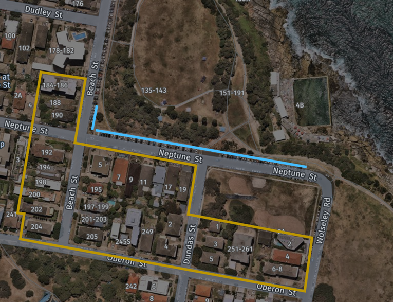
Earlier this year, at the February Traffic Committee meeting held on the 9th of February, changes to the imposed 4P time limit on Randwick’s coastal areas in response to the eased Covid restrictions were discussed. For the changes to 4P parking restriction on Neptune Street and parts of Beach Street in Coogee, it was recommended that,
The installed 4P zones to be removed and nearby residents are to be surveyed to see if they want unrestricted parking, 4P parking or 4P ‘Permit Holders Excepted’ zones.
Since the recommendation, the 4P
signs on Neptune Street and Beach Street have been covered and the zones have
since been restored to unrestricted parking, a survey was also undertaken for
the preferred option of nearby residents.
The survey offered the three options mentioned above as ‘Option 1’ being unrestricted parking, ‘Option 2’ being 4P Parking and ‘Option 3’ being 4P Permit Holders Excepted, the survey also invited additional comments from the residents.
The result of the survey is tabled below:
The majority 68% has voted for ‘Option 1’ - Unrestricted parking while 26% are supportive of 4P- Permit Holders Excepted.
From additional comments, many have raised the same concerns of visitors not being able to find parking and beach goers overcrowding neighbouring unrestricted streets under the 4P restriction regardless of permit holder’s exemption. Many comments also pointed out that finding parking is only challenging during the warmer months.
While a small portion of residents are in support of 4P-Permit Holders Excepted, some comments revealed that most residents are ineligible or unless the number of permits can be issued beyond Residential Parking Scheme Guidelines, 4P- Permit Holders Excepted will only benefit a very small portion of nearby residents.
Recommendation
That
1. Given the community response, the parking controls in the subject parts of Neptune Street and Beach revert to being unrestricted, as was existing, prior to recent changes; and
2. The nearby residents of Neptune Street and Beach, Coogee, are informed of this outcome.
|
|
|
||||||||||||||||||||||||||||||||||||||||||||||||||||||||||||||||||||||||||||
|
|
(Note: Having declared an interest, Mr. Lehmann vacated the Chair and logged out of MS Teams at this point in the meeting. The Acting Coordinator - Integrated Transport, Alexander Lin, assumed the Chair.)
In April 2020 during the current COVID-19 pandemic, Randwick City Council sought to support the frontline Prince of Wales / Sydney Children’s hospital personnel, of both Emergency Departments (ED) and both Intensive Care Units (ICU), by introducing Special Temporary Parking Zones and Permits. This was approved through the Traffic Committee processes.
For the last 13 months the Council has had special parking restrictions in place, in various streets near to the Prince of Wales Hospital campus, to assist front-line staff dealing with the effects of the Covid-19 pandemic. At the April 2021 meeting of this Committee it was recommended to have these permits and zones active until mid-May 2021 and subsequently reinstate previous parking controls.
It should be noted that in line with the termination of the special parking permits, the previous parking controls in the vicinity of Prince of Wales Hospital have been reviewed due to the change of the parking requirements with the redevelopment of the hospital. As such, for timing and installation purposes, between current and proposed parking controls, it is recommended to have the special permits and zones active until end of June 2021.
Previously unrestricted parking zones on Botany Street between High Street and Magill Street to service the residents are not required, therefore the consideration of “4P 8am-6pm Mon-Sun” is proposed to provide adequate parking facilities and turnover for people visiting the hospital, the Randwick shopping precinct and other amenities within the vicinity.
The table below lists the various streets and the parking controls prior to the signposted “No Parking, Special Permit Holders Excepted, Area – EDIC” installed as part of the COVID-19 special parking arrangement. Upon removal of the special parking zones, it is proposed to install the parking controls as per the table below (noting that the 10m No Stopping controls at intersections will be signposted, too):
Steven Nguyen (TfNSW) informed the Committee that he had previously discussed with the Council, the parking controls required along the eastern side of Botany Street, between Magill Street and High Street. He stated that his recommendation is that the Council install /maintain No Stopping controls, 20 metres on approach and departure sides of each of the Works Zones. This was agreed to by the Committee and the changes requested are indicated in the table above.
Cr Parker sought clarification on how rapidly the special parking could be rolled out, in the event that there is a sudden deterioration of conditions associated with the pandemic. Ms Bonomini (RCC) stated that the signs and permits could be installed/distributed within a few days, if required. The Committee agreed to grant delegation to Council staff to re-implement the special parking conditions in the event a further wave of the pandemic was to eventuate.
Recommendation
That:
1. That, in consideration of the Health Minister’s advice, the special temporary parking permits which were given to the hospital management, in March 2020, to be distributed to the Prince of Wales / Sydney Children’s Emergency Department and Intensive Care unit (EDIC) staff, be considered active until the end of June 2021;
2. That the parking changes, as detailed within Table 1 of this report, are approved for installation; and
3. Council staff to re-implement the special parking conditions, and re-issue special permits, in the event a further wave of the pandemic was to eventuate.
(Note: The Acting Coordinator - Integrated Transport, Alexander Lin, vacated the Chair and Mr Lehmann logged back into the meeting and resumed the Chair, at the conclusion of the above matter.)
|
|||||||||||||||||||||||||||||||||||||||||||||||||||||||||||||||||||||||||||
|
|
|
|
|
|||||||||||||
|
|
High Street, between Anzac Parade and Wansey Road, is a bi-directional local road with a two-way pop-up cycleway installed on the northern side. The pop-up cycleway was implemented following close consultation with University of NSW and the Australian Turf Club.
Transport for NSW (TfNSW) has recently requested installation of clearway signs along the northern side of High Street, between Anzac Parade and Wansey Road. The signs are aimed to ensure that the pop-up cycleway remains clear of any erroneously parked vehicles, and, to ensure that ‘tow-away’ action could be undertaken by TfNSW if such parking did occur.
However, the proposed R5-217-8N - Clearway At All Times - sign ‘is a "prescribed traffic control device" that it is NOT delegated / authorised to Councils to install. This sign can only be authorised by direct Transport for NSW written approval.’
Recommendation
That a, Clearway At All Times, parking control, is installed along the northern side of High Street, between Anzac Parade and Wansey Road, Randwick, following receipt of written approval from Transport for NSW.
|
|
|
|||||||||||||
|
|
It was proposed in the September 2020 TCM (Item TC130/20) that an exclusive 1.3m-1.4m bicycle lane be installed on the eastern side of Anzac Parade, from the intersection with Bilga Crescent through to the raised zebra crossing, south of Bilga Crescent. The recommendation arising from the meeting was that: · a detailed design to be reported back to the Committee for further consultation. BIKEast has previously made a submission related to the technical aspects of the bicycle lane which have been incorporated into the concept design (see design on the following page) as follows: · Path width is 1.3m wide + gutter width (0.45m) · Continuity lines have been included on both sides of the bicycle lane Note: The detailed design is in the May 2021 Business Paper. (Council ref D04188434) Recommendation
1. The bicycle lane, as detailed within attachment D04188434, proposed on Anzac Parade, near Bilga Crescent, Malabar, is approved for installation; and
2. This project be considered for implementation by the Council in the 2022/2023 Capital Works program.
|
|
|
|||||||||||||||||||||||||||||||||||||||||||||||||||||||||||||||||||||||||||||||||||
|
|
The following Minor Signage matters are listed for the Committee’s consideration.
Recommendation
That the recommendations listed in the Minor Signage items table, are approved for implementation / action.
|
|
|
|||||||||||||||||||||||||||||||||||||||||||||||||||||||||||||||||||||||||||||
|
|
Construction sites often involve the use of trucks, cranes and other large vehicles. Without special parking provision, the positioning of such vehicles, close to these sites, can cause significant problems for local residents or businesses. It is for this reason that the Council requires the creation of Works Zones at construction sites. Once the project is completed the Works Zone is removed (see Works Zone Conditions of Use detailed elsewhere within this document).
Accordingly, it is recommended that Works Zones be installed, or removed, at the locations detailed within the following table:
Works Zones Table
(Reference NSW Road Rule 181 )
Recommendation
That the Works Zones listed in the Works Zones Table, be installed or removed, as detailed.
Schedule Of Conditions - Installation of Works Zones
The following standard conditions may be referenced within these papers.
That:
a. The applicant be informed that if they intend to use traffic controllers for activities associated with the Works Zone, such activities must comply with a formal Traffic Control Plan (to be held on site following preparation by person/s with the appropriate Transport for NSW (TfNSW) authorisation) and that any traffic controllers utilised must have current appropriate accreditation from TfNSW;
b. The Council be given authority to replace the Works Zone with a No Stopping zone if the operator (or their sub-contractors): i. compromise pedestrian safety, or ii. add significantly to traffic congestion in this area, or iii. allow access/egress to/from the site which creates safety concerns or traffic flow delays, or iv. does not ensure that the Council fees payable for this private use of the public road are met, with the zone being reinstalled once the issue of concern is properly addressed;
c. The Council Rangers enforce the restriction; and
d. Authority be given to the Council to remove the Works Zone and reinstate the previous restrictions, when the applicant advises that it is no longer required
|
||||||||||||||||||||||||||||||||||||||||||||||||||||||||||||||||||||||||||||
|
|
|||||||||||||||||||||||||||||||||||||||||||||
|
|
The Council regularly receives requests for action to be taken with regard to vehicles being parked illegally at intersections. Such vehicles block sightlines to and from vulnerable road users such as pedestrians or bike riders. They can also obscure motorists’ views of approaching vehicles, and, they can create difficulties for fire engines, garbage trucks or other large service vehicles which need to access the neighbourhood.
To ensure compliance with the legally mandated parking prohibitions at intersections, it is recommended that No Stopping signage be installed as per the following table:
(Reference NSW Road Rule 170 )
Recommendation
That the No Stopping signage proposal, listed in the Parking Control Signage at Intersections table, be approved for installation.
|
|
|
|||||||||||||||||||||||||||||||||||||||||||||||||
|
|
This table will be updated each month and will be reported upon, at each Traffic Committee meeting.
Councillor Neilson sought clarification with regard to the Chapel Street / Frenchmans Road proposal. In particular, she stated that she would prefer that a left-turning Chapel Street motorist could pass to the inside of a right-turning Chapel Street motorist; at Frenchmans Road. Mr Lehmann informed the Committee that he would examine if this was possible.
Recommendation
That the information be received.
|
General Business
|
|
|
Urgent Matters OR Matter for Future Investigation
|
|
|||||||||||||
|
|
|
||||||||||||
|
|
Councillor Neilson enquired as to the rationale for the lengthy No Parking zone adjacent to the southern boundary of 2 Roscrea Avenue, Randwick. Mr Lehmann agreed to have this matter investigated and to report to a subsequent Traffic Committee meeting.
Recommendation
That the information be received.
|
|
|
|||||||||||||
|
|
|
||||||||||||
|
|
Councillor Shurey informed the Committee that the recently installed speed humps along Bernie Kelly Drive, seemed to be quite steep. She asked whether this facility could be checked to ensure that it complies with the relevant criteria. Mr Lehmann agreed to have these speed humps checked.
Recommendation
That the information be received.
|
The meeting closed at 10.20am.