
DRAFT MINUTES OF Traffic Committee MEETING
HELD ON Tuesday, 9 February 2021 AT 9:30am
Traffic Committee
- The following information is provided so that you may be aware of the structure and operation of the Randwick City Traffic Committee.
- The Randwick Traffic Committee is a Committee of Randwick City Council but not one set up under the Local Government Act.
- Council has been delegated certain powers from Transport for NSW (TfNSW), with regard to traffic matters upon its local roads. A condition of this delegation is that Council must take into account the Traffic Committee recommendations.
- Recommendations in this document may either activate the formal delegation from Transport for NSW to the Council, or not activate this delegation. Items which activate the delegation are indicated with the initials (AD) below the heading.
- There are four permanent members of the Traffic Committee, each of whom has a single vote only.
- The members are: the NSW Police Service, Transport for NSW, the Local State Member of Parliament (for the location of the issue to be voted upon) and Randwick City Council.
- Randwick City Council welcomes the public to register to speak at its Traffic Committee on issues of concern.
- If the Local Member disagrees with any of the Traffic Committee recommendations, they may appeal to Transport for NSW or the Minister for Roads.
- If the Police or Transport for NSW disagrees with any of the Traffic Committee recommendations, or Council’s resolution on any Traffic Committee recommendation, they may lodge an appeal with the Sydney Regional Traffic Committee for determination. The appeal must be lodged in writing within 14 days of the notification to the members of Council’s decision on the recommendation.
- Any action relative to any issue under appeal must cease until the matter is determined.
- The Sydney Regional Traffic Committee is chaired by an independent chairperson and submissions and representations are welcomed from all interested parties.
Acknowledgement of Country
Councillor Neilson volunteered to acknowledge the lands upon which this meeting is being held:
“I would like to acknowledge that we are meeting on the land of the Bidjigal and the Gadigal peoples; being the traditional owners who, for thousands of years, occupied and cared for vast areas along the Sydney Coast.
On behalf of the participants of this meeting I acknowledge and pay my respects to the Elders past, present and emerging, and also to those Aboriginal people participating today.”
Participants:
Mr Tony Lehmann Randwick City Council (Chairperson)
Mr Steven Nguyen Transport for NSW (TfNSW)
Acting Sgt Sean Madden Eastern Beaches Police Area Command
Mr Jeremy Phillips-Yelland Representative for Member for Coogee
Cr Dylan Parker Representative for Member for Maroubra
Mr Bushara Gidiess State Transit Authority
Cr Lindsay Shurey Councillor Delegate for Traffic Committee
Cr Kathy Neilson North Ward
Ms Sara Haider TfNSW
Mr Shannon Hewitt UNSW
Mr Lee Roberts BIKEast
Mr Anthony Ryan Resident
Mr Paul Chilcott Resident
Mr Leon Marskell, Ms Despina Kalavas, Ms Dilruba Akhter, Ms Heidi Leadley, Mr Hong-Sanh Hua & Ms Jai Sue - RCC
Apologies
|
|
Apologies were received from: · Representative for the Member for Heffron. |
Declaration of Pecuniary and Non-Pecuniary Interests
1. Mr Anthony Ryan (Resident) advised that he would be raising Item TC188/20 – Howard Street, Randwick – in the Matters Arising section below. He informed the Committee that, Mrs Kerrie Gibbs and family, are personal friends of his.
Matters Arising from the Minutes OR from Council Resolution
|
|
|||||||||||||
|
|
Mr Ryan enquired as to the status of this matter. Mr Lehmann explained that it was his understanding that there had been discussion with the family and that it had been agreed that the proposed pedestrian refuge, near Lee Street, be relocated much further east. He explained that a new design would have to be prepared for the new location. Mr Ryan asked whether this pedestrian refuge would be established by the end of March, as per the previous undertaking. Mr Lehmann informed the Committee that the pedestrian refuge would be installed as soon as possible; but he could not provide a specific date, at this time.
(NB: Subsequent to the meeting Mr Lehmann discovered that, whilst discussions had indeed been held between Ms Gibbs and Mr Todd Clarke, Director City Services, the subject of relocating the proposed pedestrian refuge further east had not been broached)
Recommendation
That the information be received.
|
Traffic Committee Reports
|
|
|||||||||||||
|
|
An application has been received for the installation of a 10m long Works Zone on the western side of Arden Street, Coogee, at the frontage of 200-210 Arden Street. The Works Zone is required for 16 weeks.
Currently there is “¼P, 8:30am-6:00pm, Mon-Fri, 8:30am-2:30pm Sat” parking restriction in front of the proposed site.
The Council is working with the applicant in an effort to defer this week away from the summer peak parking demand period. It is recommended that the existing ¼P restriction at the front of 200-210 Arden Street be supplanted with a Works Zone for the 16 weeks duration of construction.
Recommendation
That:
1. The existing “¼P, 8:30am-6pm, Mon-Fri, 8:30am-12:30pm Sat” parking restriction on the western side of Arden Street at the frontage of 200-210 Arden Street, be removed and replaced with a 10m long “Works Zone, 7:00am-5:00pm, Mon-Fri, 8:00am-5:00pm Sat” for the proposed 16 weeks duration of the construction works;
2. At the conclusion of the works, the Works Zone be removed and be replaced with a “¼P, 8:30am-6pm, Mon-Sun” parking restriction; and
3. The standard Works Zone conditions apply, as detailed on page 30.
|
|
|
|||||||||||||
|
|
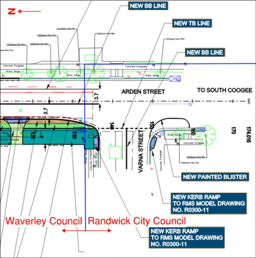
Randwick City Council has been contacted by Waverley Council regarding their traffic light upgrade on Arden Street, near Varna Street, Waverley.
As part of the project, it is proposed that additional linemarking and a kerb ramp upgrade be implemented at the intersection. Given that the boundary between Waverley Council and Randwick Council extend along the northern fence line of Varna Street, these changes are located within the Randwick local government area.
Recommendation
That the proposed construction of kerb ramps and line markings, as shown in the attached plan, be approved for installation, at the intersection of Arden Street and Varna Street, Clovelly.
|
|
|
|||||||||||||
|
|
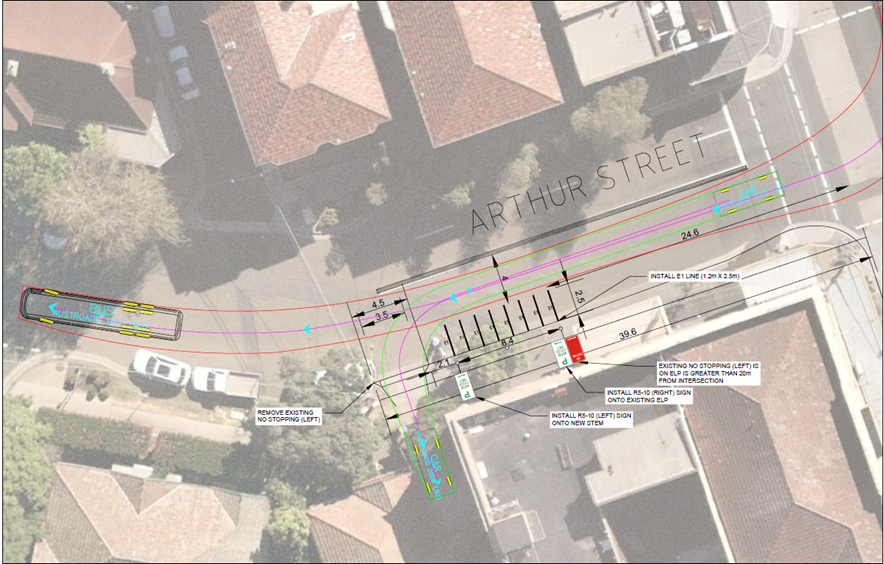
Concerns have been raised with the Council about the reduced availability of on-street parking on Belmore Road, between Alison Road and Avoca Street, due to the parking behaviour of motorcycle/ scooter users.
The installation of ‘Motor Bikes Parking Only’ on Arthur Street, near Belmore Road, would improve the ability for food delivery riders to park close to food outlets, resulting in improved parking availability along Belmore Road.
Mr Paul Chilcott (resident) enquired as to whether this proposal would preclude delivery scooters from parking elsewhere - eg, Belmore Road. Mr Lehmann advised that this proposal would not prevent scooters or motorbikes parking legally elsewhere.
Mr Lee (BIKEast) informed the Committee that Arthur Street is an essential east-west link for bike riders. He raised no objection to the proposal but noted that vehicles parked at this location would effectively narrow the roadway.
Recommendation
That:
1. The existing No Stopping on the southern side of Arthur Street, to the west of Belmore Road, be reduced from 29.1m to 24.6m; and
2. A ‘Motor Bikes Only’ parking restriction (with associated E1 line-markings) be installed on the southern side of Arthur Street, between points 24.6m and 33.0m, west of Belmore Road, Randwick, for a trial period of six-months.
|
|
|
|||||||||||||||||||||||||||||||||||||||||||||||||||||
|
|
Concerns have been raised by a resident of Bradley Lane, Randwick, regarding the “rat running” of motorists along Bradley Lane, who are seeking to avoid the traffic signals at the Botany Street and Alison Road intersection. The resident specifically complained about westbound traffic volume in Bradley Lane, in both the morning and afternoon peaks. The resident suggested that Bradley Lane be made one way easterly.
Following receipt of the resident’s concerns, a seven-day traffic count was undertaken in December, 2020.
The analysis of the data is presented in the following table.
From the above data it is evident that the volume of Bradley Lane is very low and weekday, westbound peak hourly traffic volume, is also very low (13 in peak hour). There are 196 properties combined, within Bradley Street and Bradley Lane, and it is considered that many of the trips could well have been made by these residents.
Given the very low volume of vehicles the proposal to make Bradley Lane, one way easterly, is not supported at this time.
Recommendation
That:
1. Given the very low traffic volumes involved, the suggestion to impose a one way easterly control on Bradley Lane, Randwick, is not supported; and
2. The resident be notified of the results of this investigation.
|
||||||||||||||||||||||||||||||||||||||||||||||||||||
|
|
||||||||||||||||||||||||||||||||||||||||||||||||||||||
|
|
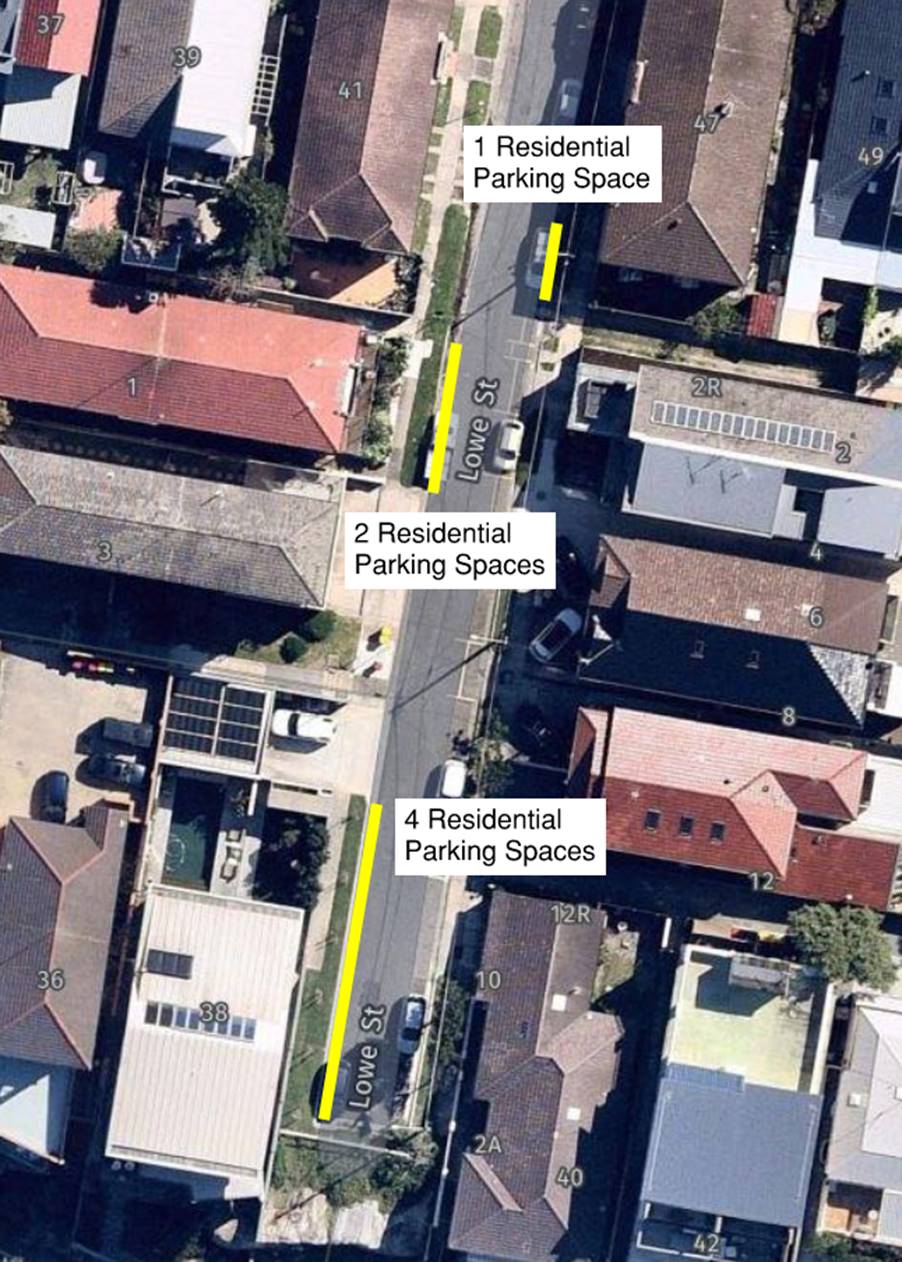
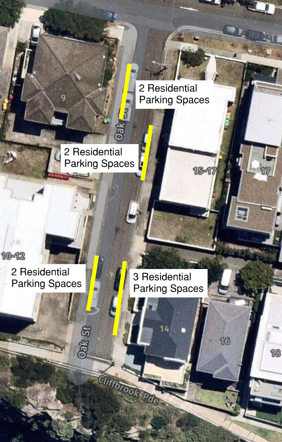
At the previous meeting of this Committee, an anomaly (highlighted at a Clovelly Precinct meeting) with regard to the recent Clovelly resident parking survey (Area CL1) was raised. Given that Cliffbrook Parade does not have any road frontages, it was agreed that the analysis of the results of the survey required a review. The results of the CL1 Resident Parking survey were re-evaluated by combining the votes of Cliffbrook Parade residents, with the votes of the residents of the street most likely to be used to access specific Cliffbrook Parade dwellings. The access streets to Cliffbrook Parade include Lowe Street, Oak Street, Thorpe Street and Tower Street. Combining the relevant Cliffbrook Parade votes with their probable access street votes, provides the results detailed in the following table. Also, included in this table are recommended changes to parking arrangements (the rationale behind these recommendations is shown below the table):
Within the four streets, the residents showed a split decision of introducing the Scheme to their street. From the four streets, Lowe Street and Oak Street did favour the introduction of the Scheme. Of these streets: 1. Lowe Street - the majority of the respondents voted yes, and those who were in support of the introduction of the Scheme preferred parking restrictions for 1 hour from Mon-Sun between 8am-8pm. However, of the 6 who voted yes, only 5 are eligible for a resident parking permit; therefore, at this time, it is proposed to install only 7 resident parking spaces within Lowe Street, as some residents who are in favour, have multiple vehicles; and
2. Oak Street - the majority of the respondents voted yes, and those who were in support of the introduction of the Scheme preferred parking restrictions for 2 hours from Mon-Sun between 8am-8pm. Of the 6 who voted yes, only 5 are eligible for a resident parking permit; therefore, it is proposed to install only 9 resident parking spaces within Oak Street, as some residents who are in favour have multiple vehicles
Figure 1: Lowe Street proposed resident parking spaces
Figure 2: Oak Street proposed resident parking spaces Mr Leon Marskell (RCC Rangers) suggested that, from an enforcement perspective, it may be preferable to have each of the restrictions having a 2P limit – rather than a mix of 1P & 2P. No objections were made to this modification.
Recommendation
That:
1. The proposed revised Resident Parking Area “CL1” is endorsed for implementation;
2. One resident parking space “2P, 8am-8pm, Mon-Sun, Permit Holders Excepted, Area CL1” be installed on the eastern side of Lowe Street, in front of property No.2 Lowe Street, adjacent to No.47 Melrose Parade, as shown in figure 1;
3. Two resident parking spaces “2P, 8am-8pm, Mon-Sun, Permit Holders Excepted, Area CL1” be installed on the western side of Lowe Street, in front of property No.1 Lowe Street, as shown in figure 1;
4. Four resident parking spaces “2P, 8am-8pm, Mon-Sun, Permit Holders Excepted, Area CL1” be installed on the western side of Lowe Street, adjacent to No.38 Cliffbrook Parade., as shown in figure 1;
5. Two resident parking spaces “2P, 8am-8pm, Mon-Sun, Permit Holders Excepted, Area CL1” be installed on the western side of Oak Street, adjacent to No.9 Melrose Parade., as shown in figure 2;
6. Two resident parking spaces “2P, 8am-8pm, Mon-Sun, Permit Holders Excepted, Area CL1” be installed on the eastern side of Oak Street, adjacent to No.11 Melrose Parade., as shown in figure 2;
7. Two resident parking spaces “2P, 8am-8pm, Mon-Sun, Permit Holders Excepted, Area CL1” be installed on the western side of Oak Street, adjacent to No.10-12 Cliffbrook Parade., as shown in figure 2;
8. Three resident parking spaces “2P, 8am-8pm, Mon-Sun, Permit Holders Excepted, Area CL1” be installed on the eastern side of Oak Street, adjacent to No.1 Cliffbrook Parade., as shown in figure 2;
9. In line with the Resident Parking Scheme review processes, this area not be surveyed again, until at least 2024, unless there is a major change to parking conditions in this area; and
10. The affected residents be notified about the proposed parking changes.
|
|||||||||||||||||||||||||||||||||||||||||||||||||||||
|
|
|||||||||||||
|
|
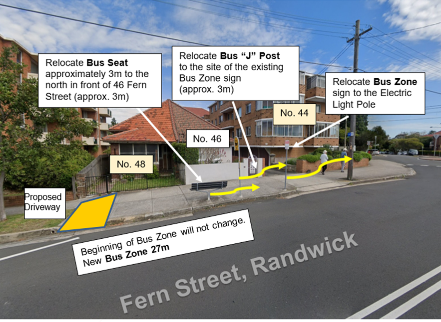
Council has received a development application (DA) from 48 Fern Street, Randwick. For the DA to proceed, it is considered that the Bus Zone should be relocated.
It is proposed to move the Bus Zone northerly (toward no. 44 Fern Street), by approximately three metres. This will allow the applicant for 48 Fern Street to construct a 3 metre driveway, at the southern boundary of their property.
A plan is attached to indicate the proposed relocation of the Bus Zone. The existing Bus Zone sign, with a left facing arrow, will be relocated northerly to the electric light pole at 44 Fern Street. The Bus “J” stem will be placed where the Bus Zone sign is currently located.
As the beginning of the Bus Zone will not change it means the Bus Zone will be extended by about 6m to around 27m.
The bus seat is proposed to be re-positioned outside 46 Fern Street as shown in the plan.
The resident adjacent has advised the Council that she raises no objection to the proposed changes.
Recommendation
That:
a) The bus zone currently outside the frontage of 46 Fern Street, Randwick, be moved 3 metres northerly (toward no 44 Fern Street); and
b) the owner/developer of 46 Fern Street, Randwick, pay all costs associated with the relocation, including the cost to relocate the bus seat.
|
|
|
|||||||||||||
|
|
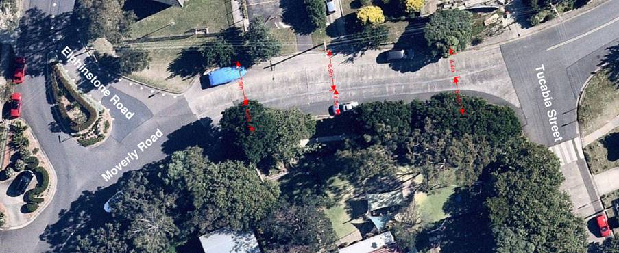
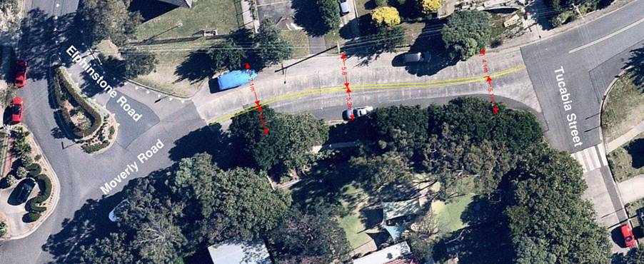
In order to reduce the likelihood of motorists traversing across the existing double centreline (BB-lines) on Moverly Road, between Elphinstone Road and Tucabia Street, South Coogee, it is proposed to shift the BB lines by 0.8m to the north, as illustrated in the diagram below.
Figure 1: Current road width with the BB-lines
Figure 2: Proposed road width with the BB-lines
Recommendation
That the existing double centrelines (BB-lines) on Moverly Road, between Elphinstone Road and Tucabia Street, South Coogee, be shifted 0.8m northerly.
|
|
|
|||||||||||||
|
|
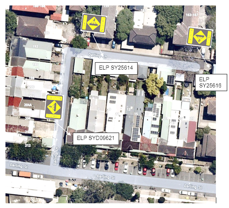
A resident has complained of speeding down Darling Lane, Kensington which is making it unsafe for her to enter and leave her driveway.
Speed signs are not appropriate for such a narrow and short lane. The proposal is to install Driveway Caution signs on three ELPs along the laneway - as shown in the attached plan.
Acting Sgt Sean Madden sought clarification on the problem in this street. Mr Lehmann explained that it was a short cul-de-sac street, with inappropriate speeds, not illegal speeds. Sgt Madden suggested that if the problem continued, Council may wish to consider the installation of speed humps. Mr Lehmann noted this suggestion.
Recommendation
That three Driveway Caution signs (W2-206A-N) be installed on electric light poles along Darling Lane, Kensington, as per the plan.
|
|
|
|||||||||||||
|
|
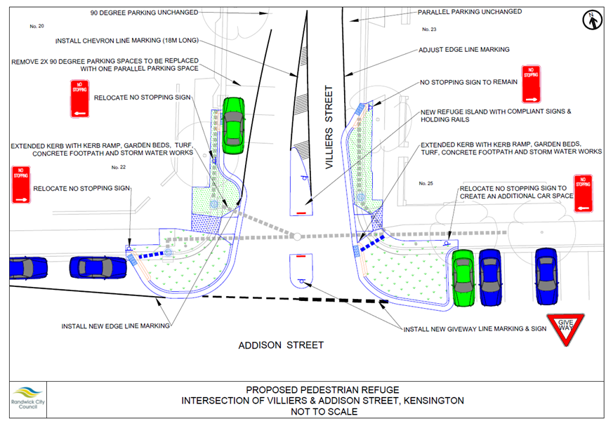
Concerns has been raised about the speed at which motorists enter Villiers Street, from Addison Street, Kensington. Pedestrians often perceive risk as they cross Villiers Street , along Addison Street.
Given these concerns and, given the propensity for many school children to travel along the northern footpath of Addison Street, it is proposed to install a pedestrian refuge.
A copy of the pedestrian refuge design is shown below.
Mr Lehmann informed the Committee that there was an error in the Recommendation. The Recommendation in the Agenda suggested the installation of a pedestrian crossing instead of a pedestrian refuge. This has now been corrected in the Minutes.
Mr Nguyen (TfNSW) asked whether Council would kindly include all dimensions on plans tabled at future Traffic Committee meetings.
Recommendation
That:
1. A pedestrian refuge be installed in Villiers Street, at Addison Street, Kensington, as per the detailed design shown; and
2. That this project be included for consideration in a future year’s Capital Works program.
|
|
|
|||||||||||||
|
|
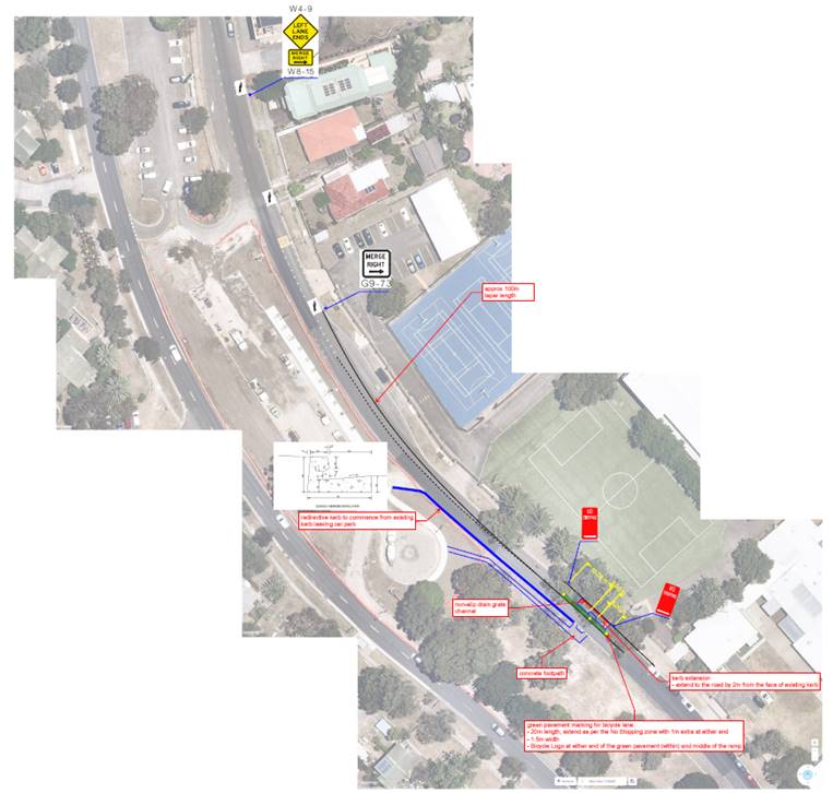
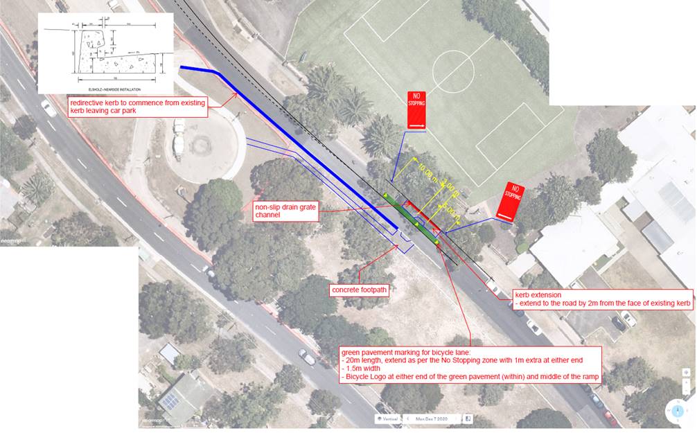
As part of the implementation of the extended median car park, on Anzac Parade, south of Beauchamp Road, a new narrowed crossing point is being installed, for local school students to move more safely, across the southbound carriageway of Anzac Parade.
Details of the proposed crossing point will be tabled at the Traffic Committee meeting. It is expected that this facility will be constructed by the end of April, 2021.
Close up of the proposed crossing point
Mr Lehmann tabled the plans of the proposed kerb nibs (Council ref D04131529). The Committee supported the proposal.
Mr Leon Marskell (Rangers) raised the issue of localised congestion occurring at the Anzac Parade / Pozieres Avenue intersection, during school pick up times. Mr Marskell suggested that consideration could be given to imposing a No Right Turn at Anzac Parade (southbound)at the Pozieres Avenue intersection, in order to alleviate this localised congestion. Mr Lehmann advised that he would have this matter investigated.
Recommendation
That the proposed Anzac Parade kerb nib and crossing point, detailed upon the Council plans tabled at the meeting (Council ref D04131529), are endorsed for installation.
|
|
|
|||||||||||||||||||||||||||||||||||||||||||||||||||||
|
|
Following concern raised by a resident about speeding in Daunt Avenue, Matraville, a seven-day traffic count was organised in front of 15 Daunt Avenue, on 1 December 2020. The analysis of the data is presented in the following table.
This traffic survey indicates that the speeds along Daunt Avenue is considered to be low in such location. Therefore, no action is deemed necessary, at this time.
Recommendation
That:
1. The results of the traffic survey for Daunt Avenue, Matraville, undertaken in December 2020, be noted; and
2. The person raising concerns about this matter be informed of the results.
|
||||||||||||||||||||||||||||||||||||||||||||||||||||
|
|
|||||||||||||
|
|
Council received numerous
residents’ concerns about accessibility issues due to traffic jams in
the street, as too many cars try to pass in both directions on busy hot
summer weekends. The residents expressed concerns about cars are
parking on the footpath as well - blocking sightlines for motorists and
pedestrians. Following an on-site meeting on 10 December, a survey of the residents of Elaroo Avenue between Adina Avenue and Yarra Road, Phillip Bay, was undertaken to get the residents’ views regarding the possible installation of No Parking restrictions on the southern side of Elaroo Avenue on Saturdays, Sundays and on Public Holidays only.
Thirty one survey letters were distributed among the residents of Elaroo Avenue, between Adina Avenue and Yarra Road. Eleven responses were received. All of the respondents were in favour of the installation of No Parking signs on Saturdays, Sundays and Public Holidays.
Councillor Parker (representative for Member for Maroubra) noted the Recommendation and advised the Committee that he was aware of upcoming meetings which would consider further intervention with regard to the parking problems in this area.
Recommendation
That:
1. A “No Parking, 10:00am-5:00pm, Sat, Sun & Public Holidays” restriction be installed on the southern side of Elaroo Avenue, between Adina Avenue and Yarra Road, Phillip Bay; and
2. The residents of Elaroo Avenue be notified before the installation of signs.
|
|
|
|||||||||||||
|
|
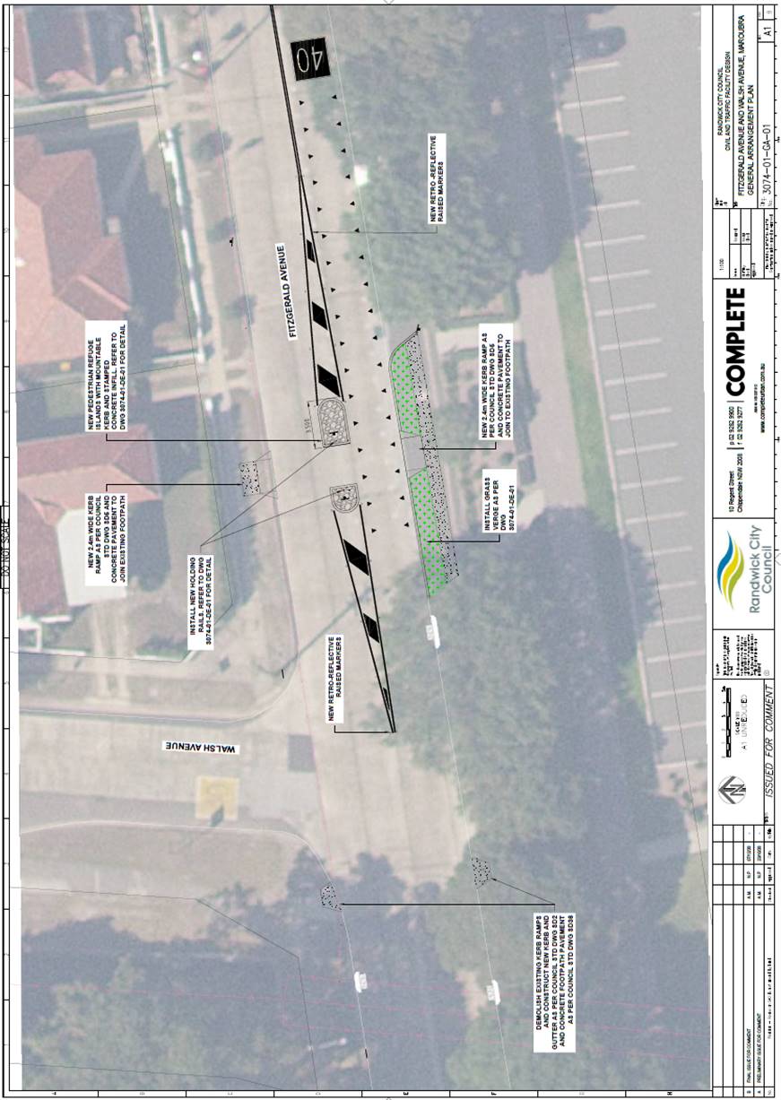
Following residents’ concerns being raised regarding the safety of pedestrians when crossing Fitzgerald Avenue, near Walsh Avenue, it is proposed to install a pedestrian refuge at this location. The proposed facility is designed to AS1742.10-2009 requirements, as there is no widening or narrowing of the carriageway proposed. The detailed design plan showing the refuge as per the Australian Standard will be tabled at the meeting.
Mr Lehmann tabled plans of the proposed pedestrian refuge (Council ref D04131570) in Fitzgerald Avenue, to the east Walsh Avenue. After some discussion, the Committee supported the Recommendation.
Recommendation
That a pedestrian refuge be installed in Fitzgerald Avenue, east of Walsh Avenue, Maroubra, as per the detailed design plan, tabled at the meeting.
|
|
|
|||||||||||||
|
|
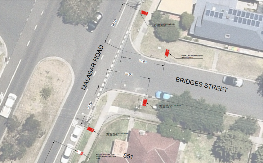
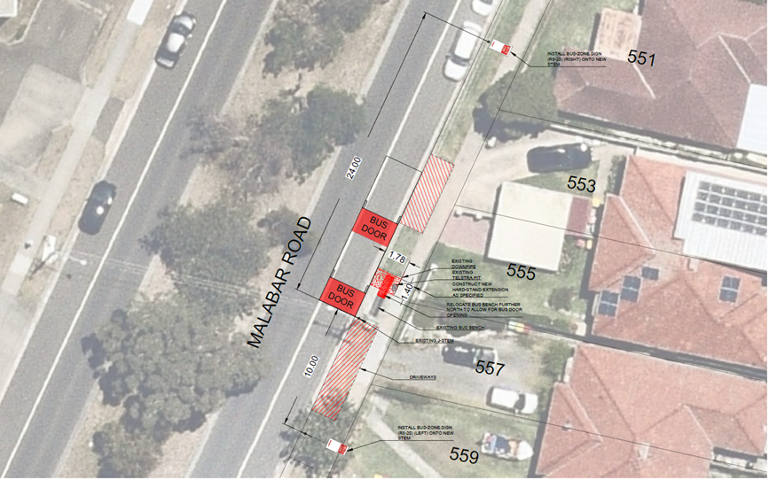
The State Transit Authority (STA) has approached Council to seek improvements for mobility access to bus services. The current layout of the concrete path and bench seat at the bus stop limits access for mobility-impaired persons. Also, parked vehicles in front of nos 555 and 557 Malabar Road, Maroubra, have resulted in restricted access for bus services due to the reduction in draw-in lengths provided for buses which reduces accessibility for those less mobile. It is proposed that bus-zone signage be installed to improve compliance in accordance with State Transit Authority (STA) Bus Infrastructure guidelines for draw-in/out lengths and Road Rule 195 regarding ‘No Stopping’ distance requirements.
As a result of these changes, it is proposed to signpost the statutory ‘No Stopping’ restrictions on all eight edges of the Malabar Road / Bridges Street intersection.
Recommendation
That:
1. No Stopping be installed on the eastern side of Malabar Road, 10.0m north and south of Bridges Street, Maroubra;
2. No Stopping be installed on the northern and southern side of Bridges Street, 10.0m east of Malabar Road, Maroubra; and
3. Bus Zone be installed on the eastern side of Malabar Road, between points 15.8m and 49.8m (24m draw-in and 10m draw-out) south of Bridges Street, Maroubra.
|
|
|
|||||||||||||
|
|
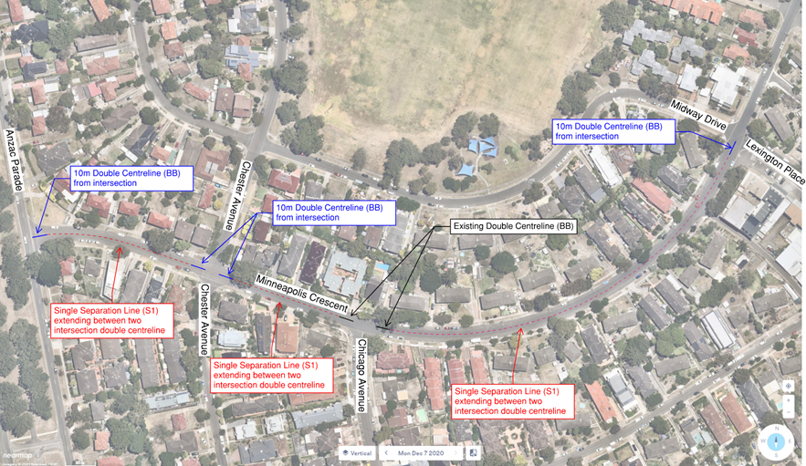
At a previous Traffic Committee meeting TC197/20, 8 December 2020, it was recommended in part that,
“Investigation be undertaken into the possible installation of appropriate lengths of double centrelines, along Minneapolis Crescent, in order to induce a reduced speed along Minneapolis Crescent”
Minneapolis Crescent is approximately 10.5m wide from Anzac Parade to Lexington Place. From Lexington Place to Yorktown Parade, Minneapolis Crescent is about 7m wide.
Linemarking could be used to discourage speeding by making the road appear narrower. As such, it is recommended that 10m long of double centrelines be installed at each intersection of Minneapolis Crescent, between Anzac Parade and Lexington Place, with a singled dashed centreline in-between, as shown by the attached concept plan.
Recommendation
That:
1. 10m long double centrelines be installed on each approach to each Minneapolis Crescent intersection, between Anzac Parade and Lexington Place, Maroubra; and
2. A single dashed centreline also be installed along Minneapolis Crescent, between Anzac Parade and Lexington Place, Maroubra, except at intersections.
|
|
|
|||||||||||||
|
|
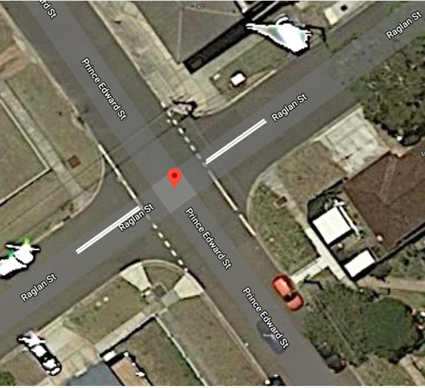
Concerns have been raised for measures to improve traffic safety at the intersection of Raglan Street and Prince Edward Street, Malabar. An analysis of the TfNSW crash data reveals that there have been no recorded crashes in the five year period, from July 2014 through to December 2019.
Motorists often cut the corner from Raglan Street onto Prince Edward Street and vice versa which in some cases may result in motorists travelling on the wrong side of the road, creating the possibility of a head-on collision.
To improve traffic safety, it is recommended that 10 metre long double separation lines be installed on Raglan Street, on both approaches to Prince Edward Street to guide motorists to the left side of the street (as shown in figure below).
Recommendation
That 10 metre long double separation lines be installed in Raglan Street, on both approaches to Prince Edward Street, Malabar.
|
|
|
|||||||||||||
|
|
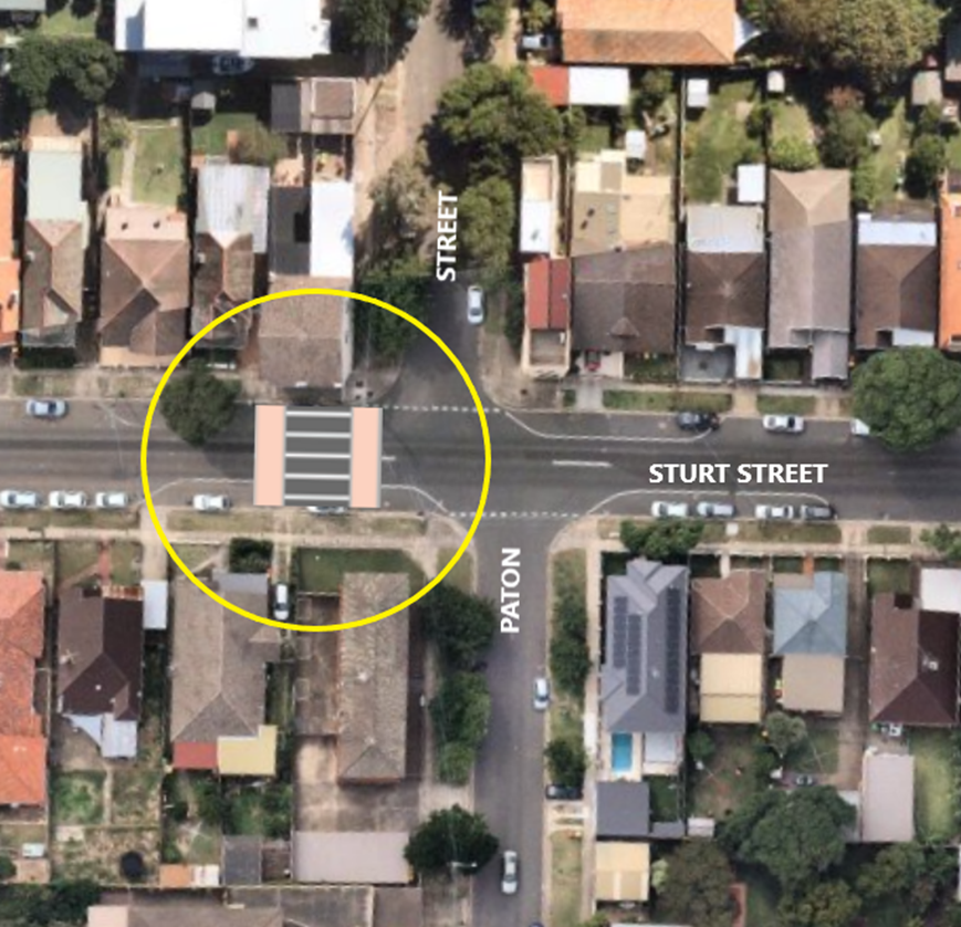
At the June 2019 meeting of this Committee, the vehicle and pedestrian study reported to the October 2018 meeting was discussed. Also, a concept design for a pedestrian crossing on the western side of the intersection was discussed.
The traffic and pedestrian counts undertaken as part of the study showed that the TfNSW/ RMS warrant for a pedestrian crossing was satisfied in Sturt Street, near Paton Street. It should be noted that pedestrian movements across Sturt Street were quite evenly distributed between the east and west side of Paton Street.
Mr Lee Roberts (BIKEast) stated it was important that this proposed facility does not conflict with the proposed cycleway. Mr Lehmann stated that the design of this facility would not affect the proposed cycleway and that consideration may be given to the installation of a construction joint at the point where the cycleway would intersect this device.
Recommendation
That:
1. A raised pedestrian crossing is established across Sturt Street, just west of Paton Street, Kingsford; and
2. The details of this proposed crossing be brought back to this Committee prior to construction.
|
|
|
|||||||||||||||||||||||||||||||||||||||||||||||||||||||||||
|
|
In October last year, given the (then) very concerning situation regarding the pandemic, a report was put to the Traffic Committee to apply a four hour parking limit (4P) to Randwick’s coastal areas. The objective was to increase turnover of people on our beaches and coastal open space areas. This would assist in managing the numbers on our beaches and along our coastal areas. Clovelly Beach specifically was predicted to see numbers that would far exceed allowable limits under the public health order existing at that time. In December, a more detailed proposal for the roll-out of the 4P time limits was referred to the technical members of the Traffic Committee (Police / Transport for NSW) for consideration. 4P signage was therefore arranged and was installed along the coastal areas in early January. Following installation of the 4P signage a number of community members raised concerns with the Council about the impacts of the new time limits - especially along the residential streets fronting the coast. Thankfully, the current health order has now been revised and does not have the previous capacity limits and our beaches are operating on as close to “business as usual” as possible. Given the easing of the public health order, and, given the concerns raised by some community members about the new time limits, it is proposed to now make adjustments to the 4P time limits. These proposed changes are to either: · Remove the 4P restriction and return the parking to ‘unrestricted parking’ or · Retain the 4P restriction but expand the Resident Parking Scheme into the street (by adding the words “Permit Holders Excepted” to the signage). The following changes are proposed:
Regarding the Clovelly carpark, we are aware that concerns have been raised by surf club patrol members and the local scuba diving companies / and diving volunteers. Accordingly, it is proposed to increase the number of parking spaces allocated to the Surf Club, from 10 spaces to 16 spaces. In addition, four parking spaces near to Gordons Bay will be signposted as “4P -Authorised Vehicles Excepted” with the local scuba diving companies / and diving volunteers being issued with Permits.
Additionally, it is proposed that a number of parking spaces be allocated in Beach Street, for use by active patrol members of the Coogee Surf Lifesaving Club (SLSC) and in the South Maroubra car park, for use by active patrol members of the South Maroubra SLSC.
Ms Susan Banki (resident) addressed the Committee with her concerns about the recent rollout of 4P time limits; especially in the Coogee Beach area. Mr Jeremy Phillips-Yelland (representative for the Member for Coogee) stated that the local Member sought clarification on the consultation and of the proposed changes.
Councillor Parker (representative for the Member for Maroubra) suggested that an overall approach should be undertaken with regard to the summer-time parking difficulties along Randwick’s coastline. Councillor Shurey agreed to this approach. Mr Lehmann suggested to the Committee that, given the input of attendees, the following approaches to the recent 4P parking restrictions, could be considered (NB: changes to proposed actions for Arcadia Street / Major Street and Neptune Street have been made)
Recommendation
That
1. the parking changes detailed in the modified table above, be implemented, as soon as possible; and
2. consideration be given to an overall management approach to coastal parking issues for summer onwards.
|
|
|
|||||||||||||
|
|
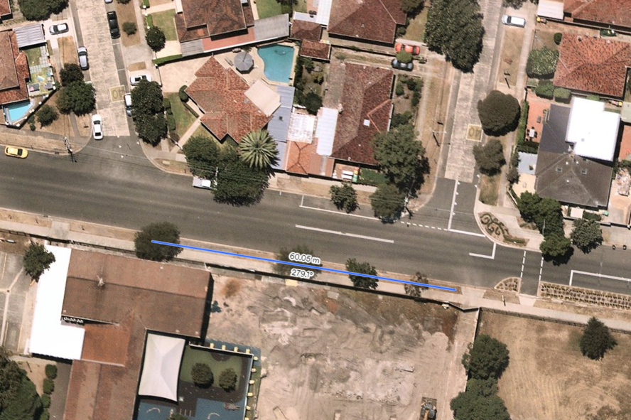
At a recent mediation meeting between residents and representatives from the school, the issue of the operation of the Kiss and Go zone, was discussed. This proposed change to the parking restriction will facilitate the operation of the Kiss and Go and assist address some of issues identified during the discussions.
It is proposed to replace the current 5 minute parking (7.30am-9.30am, 2.30pm-5pm, School Days Only) to a No Parking (8am-9.30pm, 2.30pm-4pm School Days Only) for a length of 60 metres on the southern side of Moverly Road, adjacent to the French School, Lycée Condorcet, as per the attached plan.
This restriction will be installed following full endorsement by the Lycée Condorcet and Resident Consultative Group.
Recommendation
That, subject to full agreement by the relevant parties, the existing “P5 min, 7.30am-9.30am, 2.30pm-5pm,School Days Only” be replaced with “No Parking, 8am-9.30pm, 2.30pm-4pm, School Days Only” for a length of 60 metres, on the southern side of Moverly Road, adjacent to the Lycée Condorcet.
|
|
|
||||||||||||||||||||||||||||||||||||||||||||||||||||||||||||||||||||||||||||||||||||||||||||||||||||||||||||||||||||||||||||||||
|
|
The following Minor Signage matters are listed for the Committee’s consideration.
Recommendation
That the recommendations listed in the Minor Signage items table, are approved for implementation / action.
|
|
|
|||||||||||||||||||||||||||||||||||||||||||||||||||||||
|
|
Construction sites often involve the use of trucks, cranes and other large vehicles. Without special parking provision, the positioning of such vehicles, close to these sites, can cause significant problems for local residents or businesses. It is for this reason that the Council requires the creation of Works Zones at construction sites. Once the project is completed the Works Zone is removed (see Works Zone Conditions of Use detailed elsewhere within this document).
Accordingly, it is recommended that Works Zones be installed, or removed, at the locations detailed within the following table:
Works Zones Table
(Reference NSW Road Rule 181 )
Recommendation
That the Works Zones listed in the Works Zones Table be installed or removed, as detailed.
Schedule Of Conditions - Installation of Works Zones
The following standard conditions may be referenced within these papers.
That:
a. The applicant be informed that if they intend to use traffic controllers for activities associated with the Works Zone, such activities must comply with a formal Traffic Control Plan (to be held on site following preparation by person/s with the appropriate Transport for NSW (TfNSW) authorisation) and that any traffic controllers utilised must have current appropriate accreditation from TfNSW;
b. The Council be given authority to replace the Works Zone with a No Stopping zone if the operator (or their sub-contractors): i. compromise pedestrian safety, or ii. add significantly to traffic congestion in this area, or iii. allow access/egress to/from the site which creates safety concerns or traffic flow delays, or iv. does not ensure that the Council fees payable for this private use of the public road are met, with the zone being reinstalled once the issue of concern is properly addressed;
c. The Council Rangers enforce the restriction; and
d. Authority be given to the Council to remove the Works Zone and reinstate the previous restrictions, when the applicant advises that it is no longer required.
|
||||||||||||||||||||||||||||||||||||||||||||||||||||||
|
|
|||||||||||||||||||||||||||||||||||||||||||||||||||||||||||||||||||||||||||||||||||||||||||||
|
|
The Council regularly receives requests for action to be taken with regard to vehicles being parked illegally at intersections. Such vehicles block sightlines to and from vulnerable road users such as pedestrians or bike riders. They can also obscure motorists’ views of approaching vehicles, and, they can create difficulties for fire engines, garbage trucks or other large service vehicles which need to access the neighbourhood.
To ensure compliance with the legally mandated parking prohibitions at intersections, it is recommended that No Stopping signage be installed as per the following table:
(Reference NSW Road Rule 170 )
Recommendation
That the No Stopping signage proposal listed in the Parking Control Signage at Intersections table are approved for installation.
|
|
|
|||||||||||||||||||||||||||||||||||||||||||||||||
|
|
This table will be updated each month and will be reported upon at each Traffic Committee meeting.
Recommendation
That the information be received.
|
Urgent Matters OR Matter for Future Investigation
|
|
|||||||||||||
|
|
During discussion regarding Arthur Street, Randwick - Item TC3/21, Mr Paul Chilcott (resident) mentioned the Randwick Junction Planning Strategy. He advised that some of the proposals within this strategy would be welcomed and suggested that consideration should be given to bringing some elements of this Strategy forward. He suggested, for example, that conversion of Arthur Lane, to a shared zone, may be one element which could be brought forward.
Mr Lehmann noted Mr Chilcott’s suggestion and advised that he would look into this suggestion.
Recommendation
That the information be received.
|
|
|
|||||||||||||
|
|
Mr Anthony Ryan (resident) expressed concern about the speeds at which motorists travel along Perouse Road, St Pauls Street etc. He enquired as to the progress of traffic counts for the High Pedestrian Activity Area (HPAA) of “The Spot”, Randwick. Mr Lehmann stated that he would investigate the status of the proposed traffic counts.
Recommendation
That the information be received. |
|
|
|||||||||||||
|
|
Councillor Kathy Neilson enquired as to progress with regards to proposed devices at the Chapel Street / Frenchmans Road intersection. Mr Lehmann tabled preliminary plans of a proposed pedestrian refuge in Chapel Street and kerb nibs within Frenchmans Road.
Following some discussion, it was agreed that Mr Lehmann would meet with Councillor Neilson and explain the final design proposal more fully with her.
Recommendation
That the information be received.
|
|
|
|||||||||||||
|
|
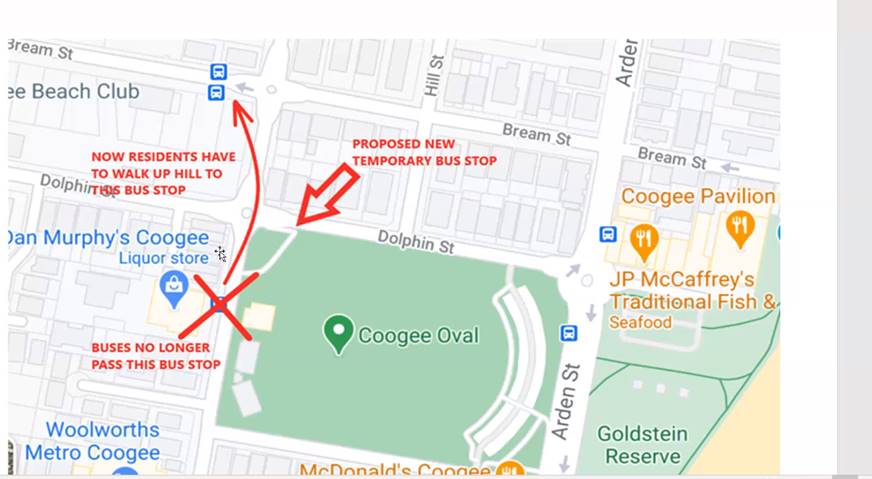
Mr Lehmann informed the Committee that the Council will soon be considering whether to extend the existing Coogee Bay Road Activation Project, for a longer time period, or not. He reminded the Committee that, due to the activation project, bus routes 374 and X74 were no longer servicing the bus stop on the western side of Brook Street, just south of Dolphin Street. This had been raised as a concern by the community.
Mr Lehmann sought the support of the Committee in proposing that a new temporary bus stop be installed on the southern side of Dolphin Street, immediately east of Brook Street, for the duration of the Coogee Bay Road activation.
Transport for NSW representative, Steven Nguyen, suggested that the STA should be consulted about this proposal. Mr Lehmann agreed.
Recommendation
That, for the duration of Coogee Bay Road activation project, a new temporary bus stop be installed on the southern side of Dolphin Street, immediately west of Brook Street, provided that the STA, is in agreement.
|
The meeting closed at 11:05am.