![]()
![]()

Traffic Committee
Meeting
Tuesday 10 November 2020
 |
|||
 |
|||
![]()
![]()
Traffic Committee
Meeting
Tuesday 10 November 2020
|
|||
|
|||
Traffic Committee
meeting
 |
Notice is hereby given that a Traffic Committee meeting of Randwick City Council
will be held on
Tuesday, 10 November 2020 at 9:30am
COVID-19
IMPORTANT NOTICE: In order to protect the health of members of our community, the representatives of other agencies and Council staff members, during the COVID-19 pandemic, the Traffic Committee meetings are being undertaken as remote meetings - using MS Teams. The meeting starts at 9.30am.
Any members of the community, wishing to make representations regarding a matter listed within the Traffic Committee Agenda, must email the Council (council@randwick.nsw.gov.au) at least 24 hours prior to the meeting. Details on how to join the meeting would then be provided.
Traffic Committee
The following information is provided so that you may be aware of the structure and operation of the Randwick City Traffic Committee.
- The Randwick Traffic Committee is a Committee of Randwick City Council but not one set up under the Local Government Act.
- Council has been delegated certain powers, from Transport for NSW (TfNSW) with regard to traffic matters upon its local roads. A condition of this delegation is that Council must take into account the Traffic Committee recommendations.
- Recommendations in this document may either activate the formal delegation from Transport for NSW to the Council, or not activate this delegation. Items which activate the delegation are indicated with the initials (AD) below the heading.
- There are four permanent members of the Traffic Committee, each of whom has a single vote only.
- The members are: the NSW Police Service, Transport for NSW, the Local State Member of Parliament (for the location of the issue to be voted upon) and Randwick City Council.
- Randwick City Council welcomes the public to participate in its Traffic Committee on issues of concern.
- If the Local Member disagrees with any of the Traffic Committee recommendations, they may appeal to Transport for NSW or the Minister for Roads.
- If the Police or Transport for NSW disagrees with any of the Traffic Committee recommendations, or Council’s resolution on any Traffic Committee recommendation, they may lodge an appeal with the Sydney Regional Traffic Committee for determination. The appeal must be lodged in writing within 14 days of the notification to the members of Council’s decision on the recommendation.
- Any action relative to any issue under appeal must cease until the matter is determined.
- The Sydney Regional Traffic Committee is chaired by an independent chairperson and submissions and representations are welcomed from all interested parties.
Attendance and Apologies
Declarations of Pecuniary and Non-Pecuniary Interests
Matters Arising from the Minutes OR from Council Resolution
Items for Consideration
At this time the Chair will ask those present at the meeting to nominate those items about which they would like some discussion or elaboration.
The Recommendations on all other items, not so nominated, will then be put to the Committee for endorsement.
TC164/20 Aeolia Lane, Randwick (C).......................................................................................... 1
TC165/20 Darley Road / Govett Street, Randwick (C)................................................................... 3
TC166/20 Howard Street, Randwick - near Lee Street (C)............................................................. 5
TC167/20 Kemmis Street / Frenchmans Road, Randwick (C)........................................................ 9
TC168/20 Randwick Resident Parking Scheme, Area RA6 (C).................................................... 13
TC169/20 Randwick Resident Parking Scheme, Area RA7 (C).................................................... 25
TC170/20 High Street, Randwick - between Anzac Parade and Wansey Road (H)........................ 31
TC171/20 Villiers Street, Kensington (H).................................................................................... 33
TC172/20 Fishermans Road, Malabar (M).................................................................................. 37
TC173/20 McCauley Street, at Perry Street, Matraville (M).......................................................... 39
TC174/20 Yarra Road, Phillip Bay (M)........................................................................................ 51
TC175/20 Minor Signage Items - Parking and Regulatory - November 2020 (C, H & M)................ 59
TC176/20 Works Zone - Installation and Removal of Signage - November 2020 (C & M).............. 63
TC177/20 Parking Control Signage At Intersections (C).............................................................. 65
TC178/20 Transport for NSW (TfNSW) Funded Project Status - November 2020 (C, H & M)......... 67
General Business
(C) Coogee Electorate (M) Maroubra Electorate (H) Heffron Electorate
Tony Lehmann
Manager Integrated Transport
Traffic Committee
meeting
|
Traffic Committee Report No. TC164/20
|
|
Subject: Aeolia Lane, Randwick (C) |
|
Index code |
Trim Ref: |
Category |
Sub Category |
By |
AD |
|
2020.11.164 |
D04020894 & D04009120 |
Signage, Parking |
No Parking |
DA |
Yes |
Parking concerns have been raised by contractors who service restaurants on the eastern side of Perouse Road, between Aeolia Street and St Pauls Street, Randwick. Most of these restaurants have grease traps and associated piping at the back of their shops, with access solely available from Aeolia Lane. However, No Parking restrictions currently exist along both sides of Aeolia Lane and trucks servicing the grease traps (usually ‘out of hours’) are unable to do so in a legally correct manner. This is because the statutory 2 minute time limit associated with No Parking controls is simply not long enough to pump out Grease Traps.
One approach which may resolve this challenge is through the application of NSW Road Rule No. 317 which is entitled “Information on or with Traffic Control Devices”. NSW Road Rule 317 states that:
(1) A traffic control device may, by the use of words, figures, symbols or anything else, indicate any of the following:
(a) the times, days or circumstances when it applies or does not apply,
(b) the lengths of road or areas where it applies or does not apply,
(c) the persons to whom it applies or does not apply,
(d) the vehicles to which it applies or does not apply,
(e) other information.
In order to satisfactorily meet the essential health and safety requirement of maintaining a clean, un-compromised, grease trap system for restaurants with rear access to Aeolia Lane, is proposed to exempt grease trap vehicles from the No Parking controls at certain hours. This can be achieved with the installation of a 31m long “No Parking, Vehicles Servicing Grease Trap Systems between 11pm and 6am Excepted” parking restriction along the western side of Aeolia Lane, between the two telegraph poles numbered 14976 and 14974. Such a signage proposal aligns with NSW Road Rule 317 as it indicates, “by the use of words” “the times… and …circumstances” when the parking restriction applies and also indicates “the vehicles to which it applies”.
|
That, in accordance with NSW Road Rule No. 317, a 31m long “No Parking, Vehicles Servicing Grease Trap Systems between 11pm and 6am Excepted” parking restriction is approved for installation along the western side of Aeolia Lane, between the two telegraph poles numbered 14976 and 14974.
|
Responsible officer: Dilruba Akhter, Transport Engineer
File Reference: F2008/00166
Traffic Committee
meeting
|
Traffic Committee Report No. TC165/20
|
|
Subject: Darley Road / Govett Street, Randwick (C) |
|
Index code |
Trim Ref: |
Category |
Sub Category |
By |
AD |
|
2020.11.165 |
D03884323 |
Pedestrian |
Pedestrian Refuge |
TL |
Yes |
Confusion sometimes arises as pedestrians and/or bike riders cross Darley Road, near Govett Street, at the same time as Parkes Drive motorists emerge from Centennial Park’s Govett Street Gates and turn left onto Darley Road.
Both the ‘crossing walkers / riders’ and the ‘emerging motorists’ wait for a significant gap in the stream of eastbound traffic. When that gap eventuates, there is often a conflict as walkers / riders and motorists quickly move into the eastbound lane at the same time. The potential for this conflict is high as the pedestrian and rider ‘path’, using the pedestrian refuge, guides them to the east of emerging motorists whose attention is most often focused upon the vehicles approaching from the west. Accordingly, as motorists commence to exit the Park, they can quickly come across people walking or riding across Darley Road, using the pedestrian refuge. This conflict has been raised with the Council by numerous residents.
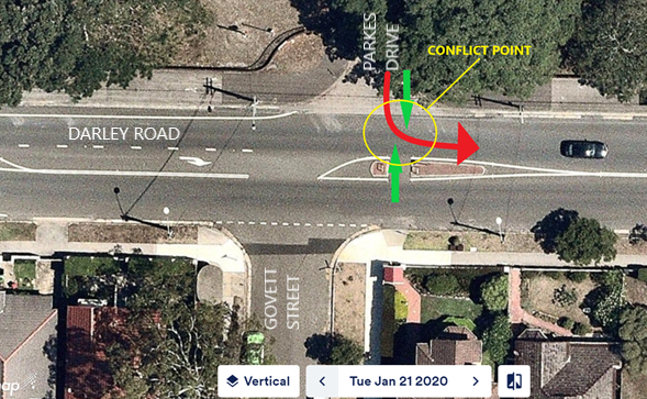
In order to address this conflict, it is proposed to change the intersection of Darley Road and Govett Street, so as to invite riders and walkers to cross to the west of the Parkes Drive intersection. With this change, walkers and riders can cross at the same time as motorists emerge from Parkes Drive.
In order to achieve elimination of this conflict point it is required that the Darley Road right turn into Govett Street be removed. Additionally, in order to also remove conflict between left turning Govett Street motorists and walkers and riders crossing west of Govett Street, it is also required that left turns be eliminated from Govett Street.
The following plan indicates the proposed changes at this intersection:
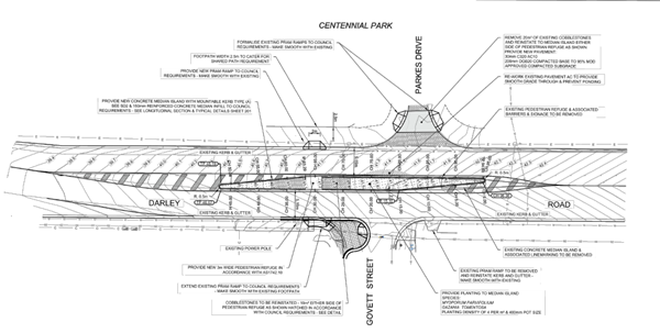
This proposal will remove conflict between turning vehicles and people walking across the road. It allows these people to ‘stage’ their crossing of the road by waiting upon the central refuge and, given the proposed kerb nib within Govett Street, it allows for enough footpath space to accommodate bunched groups of people waiting to cross Darley Road.
It should also be noted that this proposal includes the installation of a smooth surfaced crossing of Parkes Drive, which currently does not meet the Disability Discrimination Act (DDA) requirements for the mobility impaired. The installation of this smooth DDA compliant path necessitates removal of some 20m2 of cobblestones. This removal has been referred to Council’s Heritage Planner and to Centennial Park and Moore Park Trust. It was agreed that these cobblestones should be re-installed within the proposed pedestrian refuge.
As can be seen, the proposed modification will restrict movements at the intersection to only left turns from Darley Road into Govett Street. This will require that local access movements utilise the nearby intersection of Govett Street / Evans Street. This alternate intersection is controlled by a central roundabout. The proposed pedestrian refuge and kerb nib will require a detour of up to 480m for the most adversely affected Govett Street residents who wish to head west along Darley Road. The average detour is some 240m.
If the Traffic Committee was to approve the installation of the proposed Darley Road / Govett Street pedestrian refuge and kerb nib, the proposal would be released for community consultation.
|
That the pedestrian refuge and kerb nib proposed for the intersection of Darley Road and Govett Street, Randwick, together with the associated signage and linemarking, is approved for installation, following community consultation.
|
Responsible officer: Tony Lehmann, Manager Integrated Transport
File Reference: F2005/00825
Traffic Committee
meeting
|
Traffic Committee Report No. TC166/20
|
|
Subject: Howard Street, Randwick - near Lee Street (C) |
|
Index code |
Trim Ref: |
Category |
Sub Category |
By |
AD |
|
2020.11.166 |
D03865506 |
Pedestrian |
Marked Foot Crossing |
DK |
Yes |
Following recognition by the Traffic Committee (at its February 2020 meeting) that the traffic and pedestrian volumes in Howard Street, near Lee Street, did not meet the mandated TfNSW warrants for the installation of a pedestrian crossing, the Council decided to undertake further traffic and pedestrian counts.
The results of the traffic counts are shown in the following table:
|
Howard Street between Sully St and Lee St |
Direction of Travel |
|||||
|
Both directions |
Westbound |
Eastbound |
|
|||
|
Traffic Volume : (Vehicles/Day) |
Weekdays Average |
9,212 |
3,979 |
5,233 |
|
|
|
7 Day Average |
8,984 |
3,904 |
5,080 |
|
||
|
Weekday Peak hour start |
AM |
08:00 |
843 |
381 |
461 |
|
|
PM |
15:00 |
848 |
390 |
458 |
|
|
|
Speeds : (km/h) |
85th Percentile |
49.7 |
50.3 |
49.1 |
|
|
|
Average |
43.9 |
44.6 |
43.2 |
|
||
|
Howard Street between Lee St and Nelson St |
Direction of Travel |
||||
|
Both directions |
Westbound |
Eastbound |
|||
|
Traffic Volume : (Vehicles/Day) |
Weekdays Average |
9,402 |
4,064 |
5,338 |
|
|
7 Day Average |
9,141 |
3,986 |
5,155 |
||
|
Weekday Peak hour start |
AM |
08:00 |
853 |
386 |
467 |
|
PM |
15:00 |
861 |
404 |
457 |
|
|
Speeds : (Km/Hr) |
85th Percentile |
48.5 |
48.8 |
48.2 |
|
|
Average |
42.9 |
43.0 |
42.7 |
||
Mandated Transport for NSW Pedestrian (Zebra) Crossing Warrants
As previously advised, Transport for NSW (previously RMS) mandates minimum numerical warrants for pedestrian (zebra) crossings, dependant on the different categories of pedestrian user group movements. There are three Transport for NSW (TfNSW) warrants:
i) The Standard Warrant
ii) A Reduced Warrant (for sites used predominantly by children and by aged or impaired pedestrians), and
iii) A Special Warrant
The specific criteria applying to each of these Warrants are detailed as follows:
I. The Standard warrant:
A pedestrian (zebra) crossing is warranted and may be installed where:-
In each of three separate one hour periods in a typical day:
(a) the pedestrian flow per hour (P) crossing the road is greater than or equal to 30
AND
(b) the vehicular flow per hour (V) through the site is greater than or equal to 500
AND
(c) the product (P multiplied by V) is greater than or equal to 60,000
II. Reduced warrant for sites used predominantly by children and by aged or impaired pedestrians.
If the crossing is used predominantly by school children, is not suitable site for a children’s crossing and in two counts of one-hour duration immediately before and after school hours:-
(a) P ≥ 30
AND
(b) V ≥ 200
a pedestrian (zebra) crossing may be installed.
Or, if at least 50% of pedestrians using the crossing are aged or impaired and for each three one hour periods in a typical day
(a) P ≥ 30
AND
(b) V ≥ 200
AND
(c) PV ≥ 60,000
a pedestrian (zebra) crossing may be installed.
III. Special Warrant:
In certain circumstances where:-
(a) PV ≥ 45,000 (but less than 60,000)
AND
(b) P ≥ 30
AND
(c) V ≥ 500
a pedestrian (zebra) crossing may be installed.
A check of the pedestrian volumes, the traffic volumes and the mandated “pedestrian volumes multiplied by the traffic volumes” (PV) is shown in the tables below:
|
Location |
Hour |
Pedestrian Volumes |
Meets Required Pedestrian Volumes ? |
Hourly Traffic Volumes |
Meets Required Traffic Volumes? |
Pedestrians x Traffic Volumes Score (PV) |
Meets Required PV Score? |
|
Nelson Street and Lee Street Wednesday |
7am-8am |
3 |
No |
642 |
Yes |
1,926 |
No |
|
8am-9am |
12 |
No |
846 |
Yes |
10,152 |
No |
|
|
11am-12pm |
7 |
No |
508 |
Yes |
3,556 |
No |
|
|
12pm-1pm |
6 |
No |
601 |
Yes |
3,606 |
No |
|
|
2:30pm-3:30pm |
4 |
No |
668 |
Yes |
2,672 |
No |
|
|
3:30pm-4:30pm |
8 |
No |
894 |
Yes |
7,152 |
No |
|
|
4:30pm-5:30pm |
8 |
No |
765 |
Yes |
6,120 |
No |
|
|
|
|
|
|
|
|
|
|
|
Nelson Street and Lee Street Saturday |
7am-8am |
8 |
No |
302 |
No |
2,416 |
No |
|
8am-9am |
10 |
No |
469 |
No |
4,690 |
No |
|
|
11am-12pm |
7 |
No |
771 |
Yes |
5,397 |
No |
|
|
12pm-1pm |
11 |
No |
895 |
Yes |
9,845 |
No |
|
|
2:30pm-3:30pm |
4 |
No |
700 |
Yes |
2,800 |
No |
|
|
3:30pm-4:30pm |
7 |
No |
724 |
Yes |
5,068 |
No |
|
|
4:30pm-5:30pm |
9 |
No |
672 |
Yes |
6,048 |
No |
|
Location |
Hour |
Pedestrian Volumes |
Meets Required Pedestrian Volumes ? |
Hourly Traffic Volumes |
Meets Required Traffic Volumes? |
Pedestrians x Traffic Volumes Score (PV) |
Meets Required PV Score? |
|
Sully Street and Lee Street Wednesday |
7am-8am |
2 |
No |
654 |
Yes |
1,308 |
No |
|
8am-9am |
3 |
No |
853 |
Yes |
2,559 |
No |
|
|
11am-12pm |
6 |
No |
501 |
Yes |
3,006 |
No |
|
|
12pm-1pm |
7 |
No |
611 |
Yes |
4,277 |
No |
|
|
2:30pm-3:30pm |
6 |
No |
678 |
Yes |
4,068 |
No |
|
|
3:30pm-4:30pm |
5 |
No |
841 |
Yes |
4,205 |
No |
|
|
4:30pm-5:30pm |
9 |
No |
797 |
Yes |
7,173. |
No |
|
|
|
|
|
|
|
|
|
|
|
Sully Street and Lee Street Saturday |
7am-8am |
4 |
No |
297 |
No |
1,188 |
No |
|
8am-9am |
3 |
No |
466 |
No |
1,398 |
No |
|
|
11am-12pm |
10 |
No |
749 |
Yes |
7,490 |
No |
|
|
12pm-1pm |
11 |
No |
856 |
Yes |
9,416 |
No |
|
|
2:30pm-3:30pm |
8 |
No |
672 |
Yes |
5,376 |
No |
|
|
3:30pm-4:30pm |
9 |
No |
697 |
Yes |
6,273 |
No |
|
|
4:30pm-5:30pm |
10 |
No |
675 |
Yes |
6,750 |
No |
As can be seen from the above tables, whilst the vehicular volume often meets the warrant conditions, the pedestrian volumes do not. Also, the PV score is very low and does not satisfy the mandated “TfNSW numerical warrant for Pedestrian (Zebra) Crossings”.
Crash Data
In addition to the zebra crossing warrant assessment, an analysis of the safety performance of this part of Howard Street was also undertaken. Council wide crash data is provided to the Council by Transport for New South Wales, based on Police reports. The relevant data has been analysed in order to understand the pedestrian safety and vehicle crash performance, over the past five years, along Howard Street, between Sully Street and Perouse Road.
Analysis of this data shows a total of three recorded crashes. One crash was recorded near to the intersection of Ethel Street which involved a vehicle colliding into a parked vehicle/object. The other two crashes were recorded at the intersection with Sully Street:
- one involved a cross traffic crash with vehicles from adjacent directions, and
- the other involved one vehicle turning right into the path of another vehicle.
It is noted that none of the reported collisions involved pedestrians.
Given that some 3.3M vehicles travel along this part of Howard Street each year, a collision frequency of only three recorded crashes, over five years, indicates that this road is performing well from a road safety perspective.
Conclusion
Based on the preceding pedestrian crossing warrant assessment, it is clear that this part of Howard Street falls well below the mandated TfNSW warrants for the implementation of a pedestrian crossing.
When there is not a high enough concentration of pedestrians the next level of pedestrian facility is the provision of a relatively safe place, in the centre of the road, where pedestrians can wait in order to cross the road in two stages. Such a facility is known as a Pedestrian Refuge. When using a Pedestrian Refuge, the pedestrian waits for traffic approaching from the right to be clear, then they cross to a central ‘waiting place” or refuge. When traffic approaching from the left is clear the pedestrian then crosses to the kerb opposite.
Given the outcome of the analysis of the further traffic and pedestrian counts, the Council has re-commenced the design process for the installation of a pedestrian refuge within Howard Street, near Lee Street. The design will be referred back to this Committee and construction will be undertaken as soon as possible.
|
That the information be received.
|
Responsible officer: Despina Kalavas, Transport Engineer
File Reference: F2005/00825
Traffic Committee
meeting
|
Traffic Committee Report No. TC167/20
|
|
Subject: Kemmis Street / Frenchmans Road, Randwick (C) |
|
Index code |
Trim Ref: |
Category |
Sub Category |
By |
AD |
|
2020.11.167 |
D03009990 |
Pedestrian |
Pedestrian Refuge |
TL |
Yes |
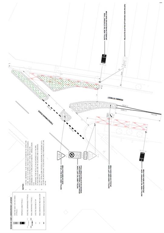
In 2017, in order to improve pedestrian safety and amenity for pedestrians crossing Kemmis Street at the Frenchmans Road intersection, the Traffic Committee endorsed the construction of a central pedestrian refuge along with the construction of a road narrowing of Kemmis Street, by building out the kerb along the eastern side.
The proposed arrangement will improve pedestrian safety and amenity by significantly reducing the current thirty metre crossing distance for pedestrians and by allowing for pedestrians to stage their crossing of Kemmis Street. The kerb build-out will also reduce speeds for vehicles turning left from Frenchmans Road into Kemmis Street. This will improve safety for all road users and will improve the visibility and awareness of pedestrians.
Following is a plan providing the final technical details of the approved proposal. These have been provided to the technical members of the Traffic Committee (Police & TfNSW representatives). The Council has addressed issues raised by these representatives and some minor changes have accordingly been made to the design.
|
That:
1. it be noted that the installation of a pedestrian refuge and road narrowing on Kemmis Street, at Frenchmans Road has been previously approved; and
2. the final details of the proposal are endorsed, as per the tabled plans. |
Responsible officer: Tony Lehmann, Manager Integrated Transport
File Reference: F2005/00825
Traffic Committee
meeting
|
Traffic Committee Report No. TC168/20
|
|
Subject: Randwick Resident Parking Scheme, Area RA6 (C) |
|
Index code |
Trim Ref: |
Category |
Sub Category |
By |
AD |
|
2020.11.168 |
D04034639 |
Signage, Parking |
Resident Parking |
AL |
Yes |
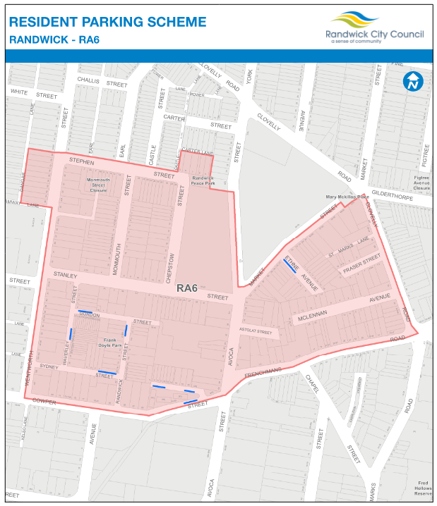
As part of its regular review of the Resident Parking Scheme (RPS), and as a result of a number of concerns expressed by residents, the operation of the resident parking scheme in the RA6 area has been reviewed. The RA6 area generally extends from Wentworth Road to Clovelly Road and is generally located between Stephen Street and Cowper Street/Frenchmans Road – as indicated within the following map.
An audit was undertaken within the RA6 Area with regard to the number of resident parking spaces available and the number of permits issued on a street-by-street basis, to ascertain if an extension of the resident parking zones is warranted.
The Council surveyed Randwick residents (within the RA6 resident parking area) in September 2020 to see if there was community support for extension of the RPS into their area. Residents received a letter informing them about the survey and some 155 responses to the survey were received.
|
About the Survey |
In September 2020, Council surveyed some 816 residents of the existing RA6 resident parking area to see if there was community support for an expansion of the Resident Parking Scheme within the area.
Those residents being surveyed received a letter from the Council with a notification regarding the online survey. Residents could respond to the survey by visiting the Council’s “Your Say” Randwick website.
Some 155 local residents responded. The following data relates to the 155 responses from residents of the proposed area.
Survey findings |
Respondents were asked questions about their household vehicle ownership and number of off street parking spaces available to them, to determine their eligibility for the resident parking scheme.
|
How many vehicles does your household
have? |
Base |
155 (100%) |
|
None |
3(1.9%) |
|
|
One |
72(46.5%) |
|
|
Two |
59(38.1%) |
|
|
Three |
19(12.3%) |
|
|
Four or more |
2(1.3%) |
The majority of households responding to the survey have one (46.5%) or two (38.1%) vehicles. Only 13.6% of the responding households have 3 or more vehicles and 1.9% have none.
|
How many off street parking does your household have? |
Base |
155 (100%) |
|
None |
70(45.2%) |
|
|
One |
70(45.2%) |
|
|
Two |
14(9.0%) |
|
|
Three or more |
1(0.6%) |
2. On Street Parking Access:
All respondents with vehicles were asked about their experiences accessing on street parking. 29.0% of respondents claimed that they never experienced problem accessing on street parking, and 42.6% said that they did experience problems both day and night.
About 7.7% of respondents claimed to experience problems finding on street parking near their residence during night time.
|
How often, if ever, do you or members of your household have difficulty finding on-street parking near your residence? |
Base |
155 (100%) |
|
Never |
45(29.0%) |
|
|
Day |
32(20.6%) |
|
|
Night |
12(7.7%) |
|
|
Day & Night |
66(42.6%) |
Overall, 45.2% of respondents were NOT in favour of the proposed extension of the resident parking scheme, compared with 48.4% who were in favour of the scheme.
|
After reading the Resident Parking Scheme Fact Sheet and map that came with the survey, do you support an introduction/extension of the Resident Parking Scheme to your area? |
Base |
155 (100%) |
|
Yes |
75(48.4%) |
|
|
No |
70(45.2%) |
|
|
Don’t know |
10(6.5%) |
The analysis of existing resident parking spaces in streets and areas and voting preferences have been presented in the following table along with any recommended changes to parking arrangements.
Street-by-Street Results of
Area RA6 and its proposed extension |
|||||
|
Street |
Voting |
No. of existing resident parking spaces |
No of existing permits |
Recommendation |
|
|
No |
Yes |
||||
|
Astolat Street |
1(100%) |
0(0%) |
0 |
0 |
No Change |
|
Avoca Street |
5(45%) |
6(55%) |
0 |
1 |
Install 4 spaces |
|
Chepstow Street |
4(67%) |
2(33%) |
0 |
0 |
No Change |
|
Clovelly Road |
1(50%) |
1(50%) |
0 |
0 |
No Change |
|
Cowper Street |
0(0%) |
5(100%) |
3 |
6 |
Install 3 additional spaces |
|
Ethne Avenue |
6(50%) |
6(50%) |
7 |
0 |
No Change |
|
Fraser Street |
2(29%) |
5(71%) |
0 |
0 |
Install 2 spaces |
|
Frenchmans Road |
4(67%) |
2(33%) |
0 |
0 |
No Change |
|
Gordon Street |
2(50%) |
2(50%) |
9 |
10 |
No Change |
|
Hodgson Street |
1(33%) |
2(67%) |
7 |
10 |
Install 3 additional spaces |
|
Market Street |
10(48%) |
11(52%) |
0 |
5 |
Install 9 spaces |
|
McLennan Avenue |
3(38%) |
5(63%) |
0 |
0 |
Install 5 spaces |
|
Monmouth Street |
5(45%) |
6(55%) |
0 |
0 |
Install 6 spaces |
|
Randwick street |
1(25%) |
3(75%) |
7 |
9 |
Install 2 additional spaces |
|
Stanley Street |
6(46%) |
7(54%) |
0 |
1 |
Install 6 spaces |
|
Stephen Lane |
1(100%) |
0(0%) |
0 |
0 |
No Change |
|
Stephen Street |
6(60%) |
4(40%) |
0 |
0 |
No Change |
|
Sydney Street |
1(50%) |
1(50%) |
5 |
1 |
No Change |
|
Waverley Street |
0(0%) |
2(100%) |
9 |
13 |
Install 1 additional space |
|
Wentworth Street |
10(67%) |
5(33%) |
0 |
0 |
No Change |
Of the twenty streets surveyed, the majority of respondents from ten streets were in favour of expanding the Scheme within their street.
Of these streets:
1. Avoca Street - further analysis of the data showed that three of the residents who voted ‘yes’ wouldn’t be eligible to be issued with a parking permit. Therefore, four new resident parking spaces will be installed;
2. Cowper Street - with three existing resident parking spaces on Cowper Street, its recommended that additional three new resident parking spaces be installed;
3. Fraser Street - further analysis of the data showed that four of the residents who voted ‘yes’ wouldn’t be eligible to be issued with a parking permit. Therefore, two new resident parking spaces will be installed;
4. Hodgson Street - with seven existing resident parking spaces on Hodgson Street, its recommended that additional three new resident parking spaces be installed;
5. Market Street - further analysis of the data showed that two of the residents who voted ‘yes’ wouldn’t be eligible to be issued with a parking permit. Therefore, nine new resident parking spaces will be installed;
6. McLennan Avenue - majority of the resident voted yes; therefore, five new resident parking spaces will be installed
7. Monmouth Street - majority of the resident voted yes; therefore, six new resident parking spaces will be installed
8. Randwick Street - with seven existing resident parking spaces on Randwick Street, its recommended that additional two new resident parking spaces be installed;
9. Stanley Street - further analysis of the data showed that one of the residents who voted ‘yes’ wouldn’t be eligible to be issued with a parking permit. Therefore, six new resident parking spaces will be installed;
10. Waverley Street - with nine existing resident parking spaces on Waverley Street and only two who voted “yes”, its recommended that additional one new resident parking spaces be installed;
The additional authorised resident spaces, recommended in the above table, are marked in the following map.
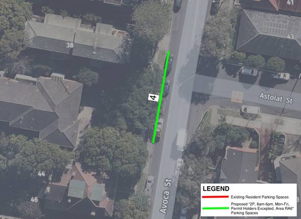
Figure 1: Avoca Street, near Astolat Street
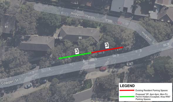
Figure 2: Cowper Street, west of Hodgson Street
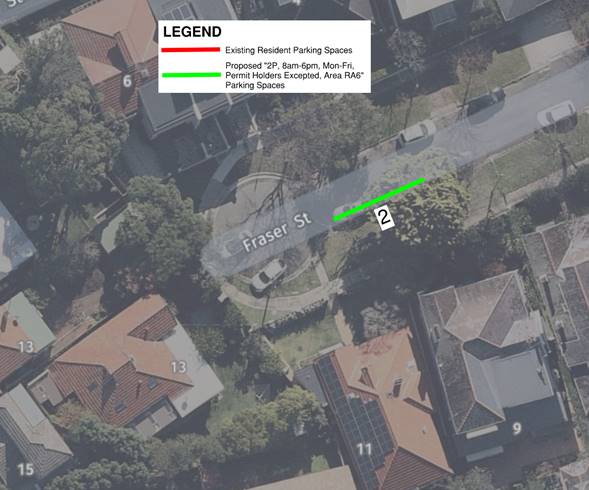
Figure 3: Fraser Street
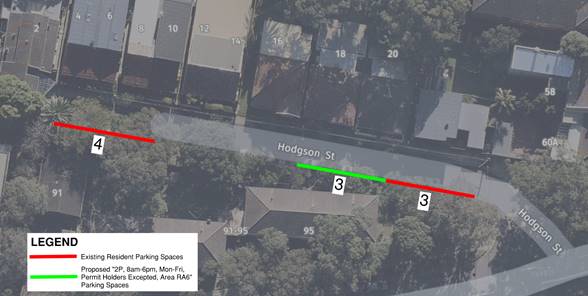
Figure 4: Hodgson Street
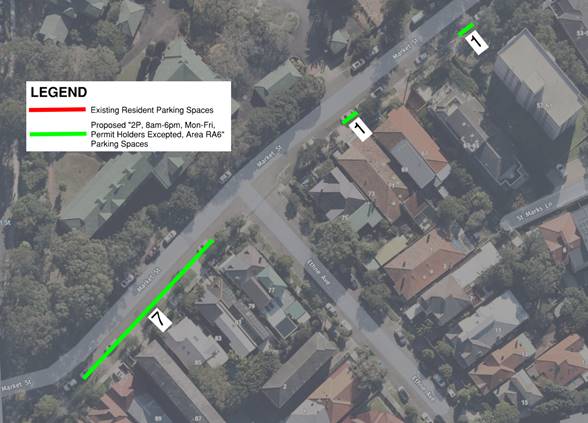
Figure 5: Market Street, west of Clovelly Road
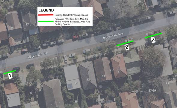
Figure 6: McLennan Avenue
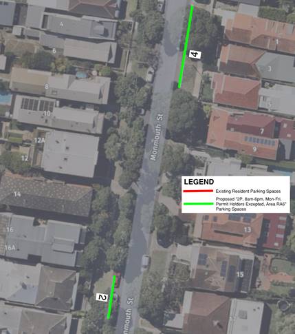
Figure 7: Monmouth Street
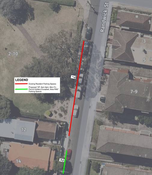
Figure 8: Randwick Street, north of Sydney Street
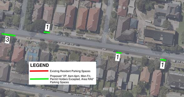
Figure 9: Stanley Street, west of Avoca Street

Figure 10: Waverley Street
|
That:
1. In response to the community feedback, the following actions be undertaken regarding expansion of the Resident Parking Scheme within Area RA6:
a) Install 4 resident parking spaces “2P, 8am-6pm, Mon-Fri, Permit Holders Excepted, Area RA6” on the western side of Avoca Street, between property no.38 and 42 driveway;
b) Install 3 resident parking spaces “2P, 8am-6pm, Mon-Fri, Permit Holders Excepted, Area RA6” on the northern side of Cowper Street, extending for 18m westerly after the existing resident parking spaces on Cowper Street as shown in the concept plan;
c) Install 2 resident parking spaces “2P, 8am-6pm, Mon-Fri, Permit Holders Excepted, Area RA6” on the southern side of Fraser Street, for 11m, at the frontage of property no. 9 and 11, as shown in the concept plan;
d) Install 3 resident parking spaces “2P, 8am-6pm, Mon-Fri, Permit Holders Excepted, Area RA6” on the southern side of Hodgson Street, extending for 18m westerly after the existing resident parking spaces on the eastern side of Hodgson Street, as shown in the concept plan;
e) Install 7 resident parking spaces “2P, 8am-6pm, Mon-Fri, Permit Holders Excepted, Area RA6” on the southern side of Market Street, between the existing MIPPS in front of property no. 91 Market Street and statutory 10m No Stopping west of Ethne Avenue;
f) Install 1 resident parking space “2P, 8am-6pm, Mon-Fri, Permit Holders Excepted, Area RA6” on the southern side of Market Street, for 5.4m, at the frontage of property no.71, as shown in the concept plan;
g) Install 1 resident parking space “2P, 8am-6pm, Mon-Fri, Permit Holders Excepted, Area RA6” on the southern side of Market Street, for 5.4m, at the frontage of property no.57-61, as shown in the concept plan;
h) Install 1 resident parking space “2P, 8am-6pm, Mon-Fri, Permit Holders Excepted, Area RA6” on the southern side of McLennan Avenue, at the frontage of property no. 23 as shown in the concept plan;
i) Install 2 resident parking spaces “2P, 8am-6pm, Mon-Fri, Permit Holders Excepted, Area RA6” on the southern side of McLennan Avenue, extending for 11m west of property no. 37-39 rear driveway;
j) Install 2 resident parking spaces “2P, 8am-6pm, Mon-Fri, Permit Holders Excepted, Area RA6” on the southern side of McLennan Avenue, extending for 11m east of property no. 37-39 rear driveway;
k) Install 2 resident parking spaces “2P, 8am-6pm, Mon-Fri, Permit Holders Excepted, Area RA6” on the western side of Monmouth Street, extending for 11m, at the frontage of property no. 18 and 20, as shown in the concept plan;
l) Install 4 resident parking spaces “2P, 8am-6pm, Mon-Fri, Permit Holders Excepted, Area RA6” on the eastern side of Monmouth Street, starting just south of property no.1 driveway and extend for 22m southerly, as shown in the concept plan;
m) Install 2 resident parking spaces “2P, 8am-6pm, Mon-Fri, Permit Holders Excepted, Area RA6” on the western side of Randwick Street, between property no. 12 and 14 driveway, as shown in the concept plan;
n) Install 3 resident parking spaces “2P, 8am-6pm, Mon-Fri, Permit Holders Excepted, Area RA6” on the southern side of Stanley Street, starting just west of property no. 3 driveway and extend for 17m westerly, as shown in the concept plan;
o) Install 1 resident parking space “2P, 8am-6pm, Mon-Fri, Permit Holders Excepted, Area RA6” on the northern side of Stanley Street, at the frontage of property no. 8, as shown in the concept plan;
p) Install 1 resident parking space “2P, 8am-6pm, Mon-Fri, Permit Holders Excepted, Area RA6” on the southern side of Stanley Street, for 5.4m, at the frontage of property no. 21, as shown in the concept plan;
q) Install 1 resident parking space “2P, 8am-6pm, Mon-Fri, Permit Holders Excepted, Area RA6” on the southern side of Stanley Street, starting just west of property no.23 driveway and extend for 5.4m westerly, as shown in the concept plan;
r) Install 1 resident parking space “2P, 8am-6pm, Mon-Fri, Permit Holders Excepted, Area RA6” on the southern side of Stanley Street, starting just west of property no.34 driveway and extend for 5.4m westerly, as shown in the concept plan;
2. In line with the Resident Parking Scheme review processes, this area not be surveyed again, until at least 2025, unless there is a major change to parking conditions in this area; and
3. The affected residents be notified about the proposed parking changes.
|
Responsible officer: Alexander Lin, Transport Engineer
File Reference: F2019/06845
Traffic Committee
meeting
|
Traffic Committee Report No. TC169/20
|
|
Subject: Randwick Resident Parking Scheme, Area RA7 (C) |
|
Index code |
Trim Ref: |
Category |
Sub Category |
By |
AD |
|
2020.11.169 |
F2019/06846 |
Signage, Parking |
Resident Parking |
DA |
Yes |
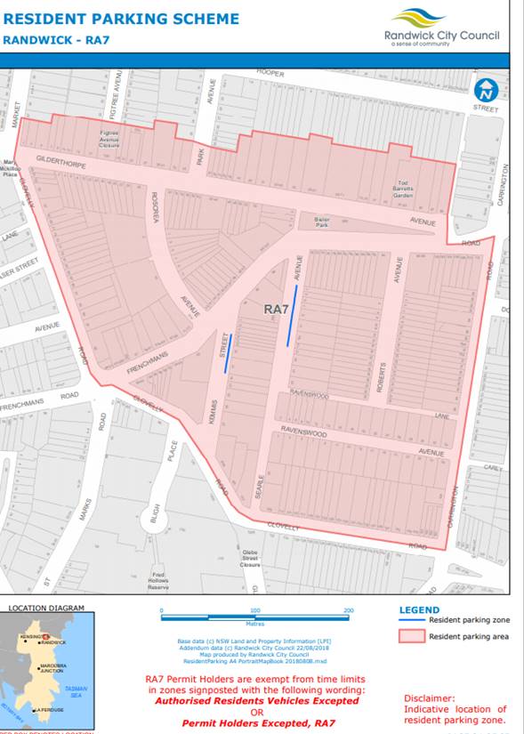
As part of its regular review of the Resident Parking Scheme (RPS), and as a result of a number of concerns expressed by residents, the operation of the resident parking scheme in the northern part of Randwick has been examined.
The Council surveyed Randwick residents (within the area RA7 resident parking area – see following map) in September 2020 to see if there was community support for extension of the RPS into their area. Residents received a letter informing them about the survey and about 146 responses to the survey were received.
|
About the Survey |
In September 2020, the Council distributed a survey letter to some 725 residences of the northern part of the Randwick area comprising the existing RA7 resident parking area to see if there was community support for extension of the Resident Parking Scheme into the other streets of the area.
Those residents being surveyed received a letter from Randwick City Council with a notification regarding the online survey. Residents could respond to the survey by visiting the Council’s Your Say Randwick website.
Some 146 local residents responded. The following data relates to the 146 responses from residents of the area.
|
Survey findings |
1. Eligibility:
Respondents were asked questions about their household vehicle ownership and number of off-street parking spaces available to them, to determine their eligibility for the resident parking scheme.
|
How many vehicles does your household have? Please include company cars that are usually brought home |
Base |
146 (100%) |
|
None |
4(2.7%) |
|
|
One |
70(48%) |
|
|
Two |
59(40.4%) |
|
|
Three or more |
13(8.9%) |
The majority of households responding to the survey have one (48%) or two (40.4%) vehicles. Only 8.9% of the responding households have 3 or more vehicles and 2.7% have none.
|
How many off street parking does your household have access to? |
Base |
146 (100%) |
|
None |
57(39.04%) |
|
|
One |
76(52.05%) |
|
|
Two |
12(8.22%) |
|
|
Three or more |
1(.69%) |
2. On Street Parking Access:
All respondents with vehicles were asked about their experiences accessing on street parking. 36.3% of respondents claimed that they never experienced problem accessing on street parking, and 38.35% said that they did experience problems both day and night.
Almost 16.43% of respondents claimed to experience problems finding on street parking near their residence during night time.
|
How often, if ever, do you or members of your household have difficulty finding on-street parking near your residence? |
Base |
146 (100%) |
|
Never |
53(36.3%) |
|
|
Day |
13(8.9%) |
|
|
Night |
24(16.43%) |
|
|
Day & Night |
56(38.35%) |
The analysis of existing resident parking spaces in streets and areas and voting preferences have been presented in the following table along with any recommended changes to parking arrangements.
|
Street-by-Street Results of Area RA7 and its proposed extension Resident Parking Survey |
|||||
|
Street |
Voting |
No. of existing resident parking spaces |
No. of existing permits |
Recommendation |
|
|
No |
Yes |
||||
|
Barrett Place |
1 |
0 |
0 |
The resident will not be eligible for permit |
|
|
Carrington Road |
4 |
1 |
0 |
0 |
Majority respondents against the extension |
|
Clovelly Road |
7 |
5 |
0 |
0 |
Majority respondents against the extension |
|
Frenchmans Road |
9 |
5 |
0 |
0 |
Majority respondents against the extension |
|
Gilderthorpe Avenue |
22 |
17 |
0 |
0 |
Majority respondents against the extension |
|
Kemmis Street |
1 |
5 |
8 |
1 |
Extension of resident parking scheme is not warranted |
|
Ravenswood Avenue |
15 |
2 |
0 |
0 |
Majority respondents against the extension |
|
Roberts Avenue |
12 |
2 |
0 |
0 |
Majority respondents against the extension |
|
Roscrea Avenue |
7 |
5 |
0 |
0 |
Majority respondents against the extension |
|
Searle Avenue |
0 |
12 |
10 |
2 |
Extension of resident parking scheme is not warranted |
Of the ten streets surveyed, the majority of respondents from seven streets were against the expanding the Scheme within their street. The remaining three streets voted in favour of the scheme, but the extension of the scheme is not warranted.
Of these streets:
1. Barrett Place: Only one vote (100%) received in favour of the scheme but the resident wouldn’t be eligible for the permit as he has off street parking for his vehicle;
2. Searle Avenue: All the votes were in favour (100%) of the scheme but there are currently 10 resident parking spaces available in the street and only two permits were issued. Therefore, the extension is not warranted; and
3. Kemmis Street: 83% votes were in favour of the extension but there are 8 resident parking spaces available and only 1 permit was issued. Therefore, the extension is not warranted as there are sufficient resident parking spaces available.
|
That:
1. Given the results of the Resident Parking Survey, no extension of the resident parking scheme be undertaken within Area RA7, at this time;
2. The residents within Area RA7 be notified of this result; and
3. In line with the Resident Parking Scheme review processes, this area not be surveyed again for four years, unless there is a major change to parking conditions in this area.
|
Responsible officer: Dilruba Akhter, Transport Engineer
File Reference: F2019/06846
Traffic Committee
meeting
|
Traffic Committee Report No. TC170/20
|
|
Subject: High Street, Randwick - between Anzac Parade and Wansey Road (H) |
|
Index code |
Trim Ref: |
Category |
Sub Category |
By |
AD |
|
2020.11.170 |
D04048863 |
Signage, Parking |
No Stopping |
TL |
Yes |
In reviewing likely arrangements for the High Street pop-up cycleway, both University of NSW (UNSW) and the Australian Turf Club (ATC) indicated that they would see benefit in the on-street parking between Anzac Parade and Wansey Road, being time-limited.
It is understood that numbers of students living in the UNSW High Street fronting apartments are choosing to not occupy the underground carparks but are, instead, monopolising the on-street parking. There is also a situation whereby some ‘longer-term’ parked vehicles have become abandoned and do not move. Application of an appropriate time limit would greatly assist in freeing up space along High Street to meet the current parking demands.
Further consultation with both UNSW and ATC is expected to be undertaken soon and the proposed time limits will be discussed at the Traffic Committee meeting.
|
That the proposed parking time limits for High Street, between Anzac Parade and Wansey Road, Randwick, be tabled at the meeting and be discussed.
|
Responsible officer: Tony Lehmann, Manager Integrated Transport
File Reference: F2008/00166
Traffic Committee
meeting
|
Traffic Committee Report No. TC171/20
|
|
Subject: Villiers Street, Kensington (H) |
|
Index code |
Trim Ref: |
Category |
Sub Category |
By |
AD |
|
2020.11.171 |
F2019/00613 |
Linemarking |
Parking |
AL |
Yes |
As part of the Integrated Smart Parking Project, the Council is monitoring the parking demand on Villiers Street, Kensington, with the use of in-ground sensors to identify how many parking spaces are available in a given area. This will allow for the real-time notification to motorists of available parking on Villers Street. This notification will be via onsite digital signage or the PayStay app to direct motorists to available parking.
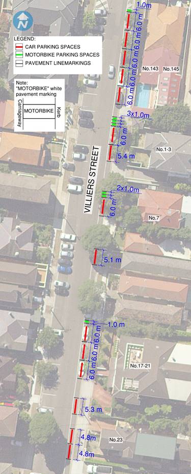
In-ground sensors work by inserting a small sensor in each parking space. The sensors are typically installed flush with the ground or slightly below the surface and covered to ensure that they don’t pose a trip hazard. The sensor detects when a vehicle is parked in the parking space and sends this information back to a central processing platform. In-ground sensors are the simplest and most widespread method used for monitoring parking availability. In order to introduce better parking discipline, and to have the sensors operate better, linemarking of the parking spaces is required. Accordingly, it is proposed that the existing parallel parking spaces on the eastern side of Villers Street, Kensington, be linemarked, as indicated upon the following concept plan.
|
That the linemarking proposed for the eastern side of Villers Street, Kensington, is approved for installation.
|
Responsible officer: Alexander Lin, Transport Engineer
File Reference: F2008/00334
Traffic Committee
meeting
|
Traffic Committee Report No. TC172/20
|
|
Subject: Fishermans Road, Malabar (M) |
|
Index code |
Trim Ref: |
Category |
Sub Category |
By |
AD |
|
2020.11.172 |
D04018880 |
Signage Parking |
No Stopping |
DK |
Yes |
Concerns have been raised with the Council regarding parking practices in Fishermans Road, Malabar. Representatives from the Randwick Offshore Rescue Boat (Surf Rescue 30) have advised the Council that on numerous occasions, especially during high summertime, motorists park their vehicles on both sides of Fishermans Road commencing from the Malabar Wastewater Treatment Plant to the entry of the car park causing difficulties for emergency vehicles to access the boat ramp.
In addition, a number of residents that visit the beach or Malabar Coastal Walk and frequent users of the boat ramp have advised that due to the recent pandemic and the change of peoples’ life style and behaviour, an increased number of people are visiting this area. This is resulting in high parking demand and increased numbers of pedestrians walking along the roadway in order to maintain social distancing.
Vehicles parked around the bends, near the intersections and kerb ramps are impeding sightlines for pedestrians and motorists trying to manoeuvre their boat trailers around the bends and entry/exit points. Another point that was noted by frequent boat ramp users is that when vehicles are parked around the bend, they find in difficult to often enter the car park, manoeuvre to and from the ramp.
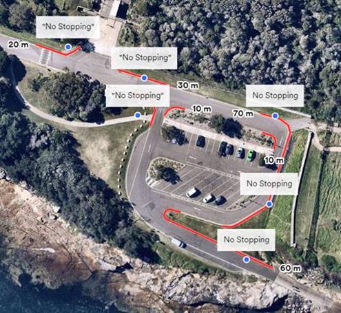
Figure 1: proposed “No Stopping” zones at Fishermans Road Car Park, Malabar
A number of site inspections were undertaken, including warm days with an increased number of visitors at this location. During a typical warmer weekday, the parking was highly utilised and the angled parking spaces in proximity to the beach and within the car park were all at capacity. Whilst the parallel on street parking was still available, it was observed that many vehicles were parked near intersections, or around the bends at the car park. Vehicles parked at those locations, impede the movements for the users of the boat ramp negotiating the turns through Fishermans Road and within the car park.
Consequently, the No Stopping zones as presented in Figure 1, are proposed to be installed in order to deter motorists parking at the bends near the entry/exit points of the car park and the intersections. This will ensure that service vehicles, emergency vehicles and boat trailers can easily access the roadway and boat ramp whilst navigating safely through the car park.
|
That the installation of the “No Stopping” zones on / at the Fishermans Road Car Park as included within this report are approved for installation.
|
Responsible officer: Despina Kalavas, Transport Engineer
File Reference: F2008/00166
Traffic Committee
meeting
|
Traffic Committee Report No. TC173/20
|
|
Subject: McCauley Street, at Perry Street, Matraville (M) |
|
Index code |
Trim Ref: |
Category |
Sub Category |
By |
AD |
|
2020.11.173 |
D03771109 & D03789121 |
Traffic Device |
Refuge |
DA |
Yes |
In order to achieve better compliance with heavy vehicle movement restrictions at the Perry Street / McCauley Street intersection it is proposed to modify the intersection. The modification consists of kerb build outs, a large traffic island and a pedestrian refuge, as detailed in the following images:
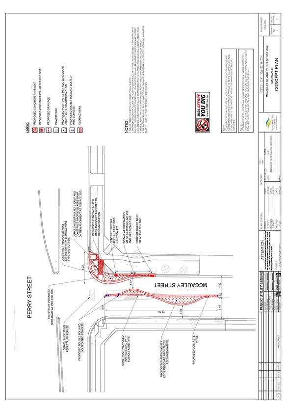
Drawing 1 - Concept Plan
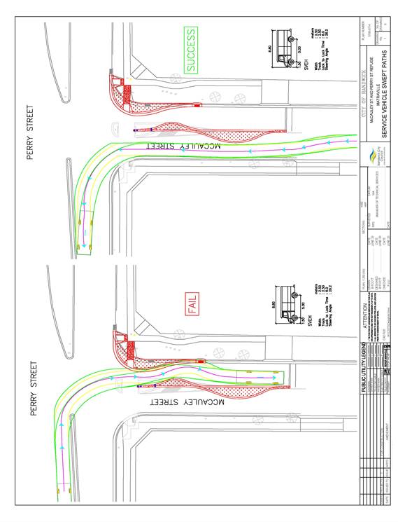
Drawing 2 - Service Vehicle Swept Paths (1/8)
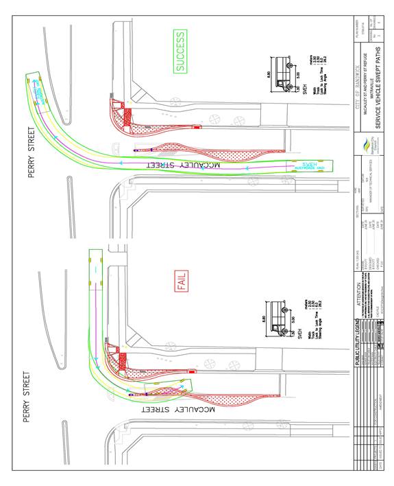
Drawing 3 - Service Vehicle Swept Paths (2/8)
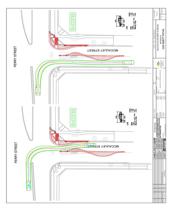
Drawing 4 - Car Swept Paths (3/8)
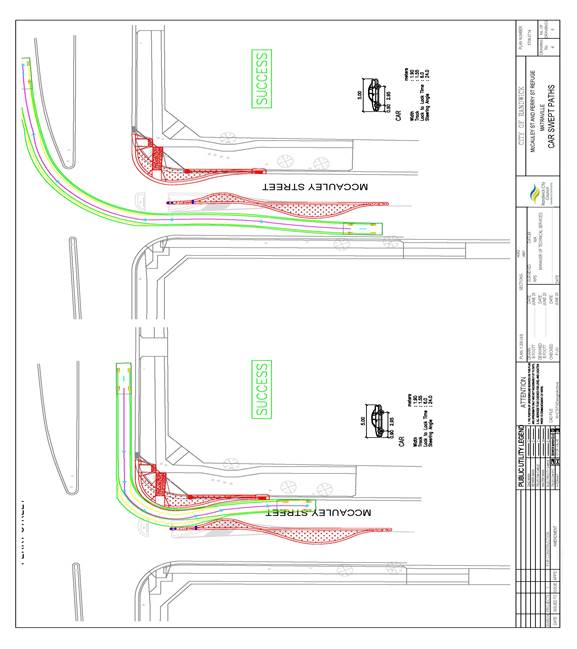
Drawing 5 - Car Swept Paths (4/8)
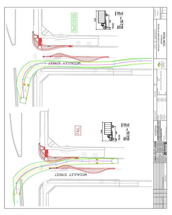
Drawing 6 - 12.5m Truck Swept Paths (5/8)
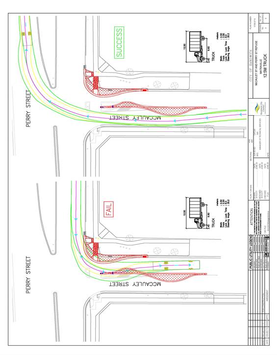
Drawing 7 - 12.5m Truck Swept Paths (6/8)
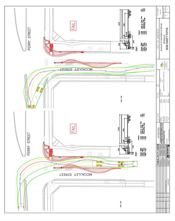
Drawing 8 - Semi Truck Swept Paths (7/8)
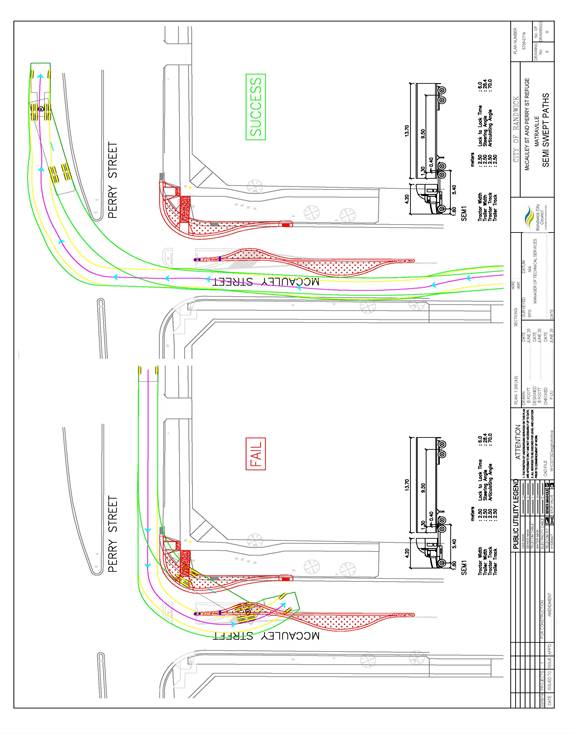
Drawing 9 - Semi Truck Swept Paths (8/8)
In September 2020, the Council informed the local community about the proposed traffic device. The current design does not allow any vehicles 8.8m or over to enter McCauley Street, from Perry Street. Vehicles up to 12.5m are able to turn east onto Perry Street when exiting from McCauley Street. 12.5m vehicles and over are only able to turn west onto Perry Street when exiting from McCauley Street.
|
That the kerb build outs, large traffic island and pedestrian refuge, as proposed at the Perry Street / McCauley Street intersection, are approved for construction.
|
Responsible officer: Dilruba Akhter, Transport Engineer
File Reference: F2020/00525
Traffic Committee
meeting
|
Traffic Committee Report No. TC174/20
|
|
Subject: Yarra Road, Phillip Bay (M) |
|
Index code |
Trim Ref: |
Category |
Sub Category |
By |
AD |
|
2020.11.174 |
D04009611 & D04022394 |
Road Safety |
Road Safety |
AL |
Yes |
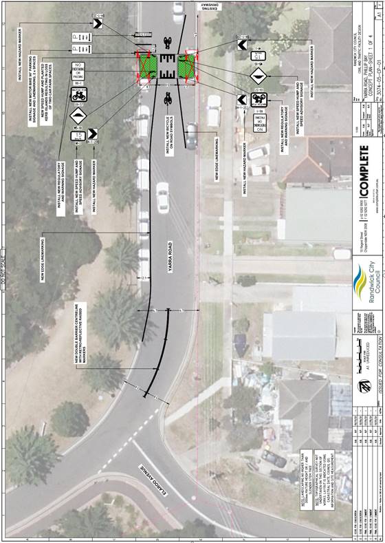
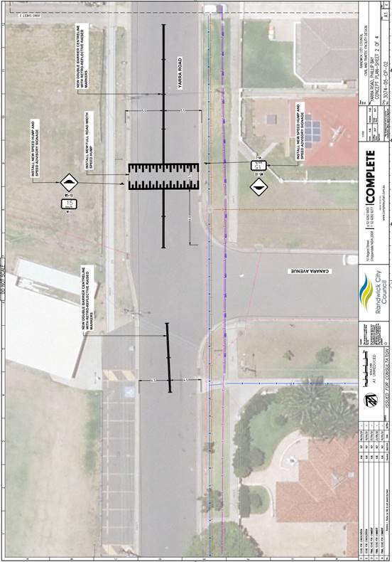
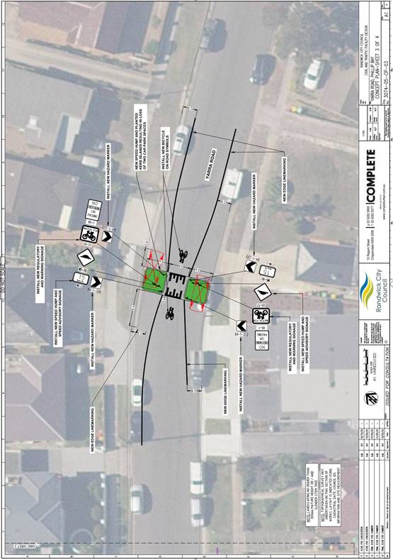
At the September 2019 meeting of the Traffic Committee, Item 4.13, it was recommended that to address the anti-social “hoon” behaviour on Yarra Road, the installation of a number of traffic control devices on Yarra Road be approved, in principal, and be the subject of community consultation with the Yarra Road community.
Consequently, after significant community engagement, and further design refinement, the final design of the proposed traffic calming devices is tabled.
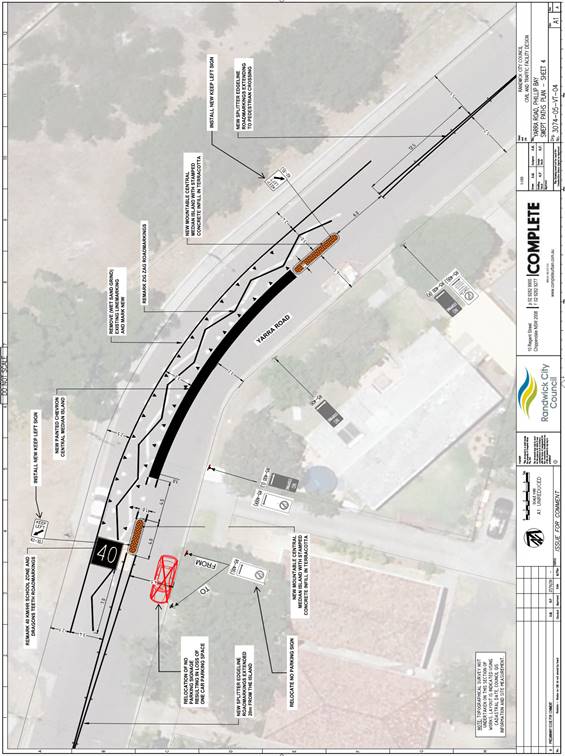
|
That the Yarra Road traffic calming devices, pavement markings and associated signage, as detailed within this report, are approved for construction and installation.
|
Responsible officer: Alexander Lin, Transport Engineer
File Reference: F2020/00226
Traffic Committee
meeting
|
Traffic Committee Report No. TC175/20
|
|
Subject: Minor Signage Items - Parking and Regulatory - November 2020 (C, H & M) |
|
Index code |
Trim Ref: |
Category |
Sub Category |
By |
AD |
|
2020.11.175 |
D04039863 |
Signage, Parking |
2P |
DK |
Yes |
The following Minor Signage matters are listed for the Committee’s consideration.
|
Item No |
Location |
Issue Request |
Recommend Approval? |
Comments |
|
TC175/20.1 |
Arthur Street RANDWICK (C) (D04039863-DK) (AD) |
Remove the Bus Zone on the southern side of Arthur Street, Randwick, commencing immediately west of Clara Street and terminating at the western boundary of No.56b Arthur Street and reinstate the previous resident parking zone “2P 8am-6pm Mon-Fri Permit Holders Excepted Area RA1”. |
Yes |
This temporary Bus Stop no longer required now that light rail construction activities have ceased. |
|
TC175/20.2 |
Clara Street, RANDWICK (C) (D04039863-DK) (AD) |
Extend the existing Bus Zone on the west side of Clara Street, Randwick, adjacent to No.34B Blenheim Street, commencing 12m northerly from High Street and terminating at a distance 32m at the ELP. |
Yes |
Extend the Bus Zone to accommodate two buses to avoid queuing on High Street |
|
TC175/20.3 |
Clara Street, RANDWICK (C) (D04039863-DK) (AD) |
Extend the existing Bus Zone on the east side of Clara Street, Randwick, adjacent to the loading dock for Coles by 10m northerly. |
Yes |
Extend the Bus Zone to allow for adequate draw-in/ park parallel to the kerb. |
|
TC175/20.4 |
Coogee Bay Road, COOGEE (C) (D03994821-AL) (AD) |
Convert existing 16m parking restriction of “½P, 8:30am – 6pm, Mon-Fri”, on the northern side of Coogee Bay Road, Coogee, at the frontage of 114 Coogee Bay Road, into “1P, 8:30am - 6pm”. |
Yes |
To better accommodate the needs of local Coogee Bay Road businesses, near Melody Street. |
|
TC175/20.5 |
Coogee Bay Road, COOGEE (C) (D04011359-AL) (AD) |
Install a new “P15, 7am-5pm” parking restriction on the southern side of Coogee Bay Road, Coogee, starting just east of 97 Coogee Bay Road driveway and extending easterly for 5.4m. |
Yes |
To better accommodate the needs of local Coogee Bay Road businesses, near Melody Street. |
|
TC175/20.6 |
Denning
Street, |
Yes |
To assist eligible mobility impaired residents to be picked up and dropped off, close to their property. To be approved upon receipt of a statutory declaration. |
|
|
Kemmis Street RANDWICK (C) (D04032633-DA) (AD) |
Install 8m Loading Zone 7:00am-12:00pm, Mon-Sun, on the west side of Kemmis Street, Randwick, commencing immediately north from the driveway of 62 Frenchmans Road property. |
Yes |
To assist with the deliveries of QE Food Store located at 62 Frenchmans Road, Randwick. |
|
|
TC175/20.8 |
Black Lion
Place, |
Extend the current No Parking zone located at the frontage of the stair access of no.97 Brompton Road, Kensington, approximately 5m north, to the adjacent driveway. |
Yes |
To allow emergency vehicles and taxis to park close to the stair access when picking up and dropping off residents. |
|
TC175/20.9 |
See Lane, KINGSFORD (H) (D03984339-RM) (AD) |
Extend the existing No Parking zone located on the northern side of See Lane, opposite the rear of 22 Borrodale Road, by 15m easterly, to a point directly opposite to the property boundary of no.24 and no.26 Borrodale Road, Kingsford. |
Yes |
To prevent parked vehicles obstructing the rear access of property No.24 Borrodale Road. |
|
TC175/20.10 |
Sturt Street, KINGSFORD (H) (D03794967-RM) (AD) |
Install 6m Mobility Impaired Person’s Parking Space (MIPPS) directly in front of 53 Sturt Street, Kingsford. |
Yes |
To meet the current needs of the resident; to be reviewed as cycleway plan evolves. |
|
TC175/20.11 |
Ireton Street, MALABAR (M) (D03630843-AL) (AD) |
Withdraw previously proposed 30m extension of “No Parking, 8am-9:30am, 2:30pm-4pm, School Days Only”, on the northern side of Ireton Street, Malabar, in November 2019 Traffic Committee, Item no.4.13. |
Yes |
Following further review, it was considered to not proceed with the proposal. |
|
TC175/20.12 |
Maroubra Road, MAROUBRA (M) (D04038707-DA) (AD) |
Amend the approval in September Traffic Committee meeting (TC 136/20.9) “15 minutes parking, 8:30am-6:00pm, Mon-Fri, 8:30am-12:30pm Sat” to “15 minutes parking, 10am-10pm, Mon-Sun” on the southern side of Maroubra Road, in front of 17 Maroubra Road, Maroubra. |
Yes |
To better suit the opening hours’ needs of adjacent Maroubra Road businesses, near Bunnerong Road. |
|
TC175/20.13 |
Mitchell
Street, |
Install a Mobility Impaired Person’s Parking Space (MIPPS) at the 45° angle parking space on the eastern side of Mitchell Street, at the frontage of no.41 Mitchell Street, Chifley. |
Yes |
To assist the access needs of an eligible mobility impaired resident.
|
|
TC175/20.14 |
Wild Street, |
Change current ‘No Stopping, 8am-1pm, Sundays Only’ zone located on the eastern side of Wild Street, Maroubra, adjacent to Wild Street Anglican Church to ‘Mobility Impaired Person’s Parking Space (MIPPS), 8am-1pm, 4pm-6pm Sundays Only’. |
Yes |
To assist eligible mobility impaired residents be picked up and drop off close to the church on Sundays. |
|
That the recommendations listed in the Minor Signage items table, are approved for implementation / action.
|
Responsible officer: Jai Sue, Administrative Support - City Services
File Reference: F2012/00032
Traffic Committee
meeting
|
Traffic Committee Report No. TC176/20
|
|
Subject: Works Zone - Installation and Removal of Signage - November 2020 (C & M) |
|
Index code |
Trim Ref; |
Category |
Sub Category |
By |
AD |
|
2020.11.176 |
D0402814 |
Signage Parking |
Works Zone |
DK |
Yes |
Construction sites often involve the use of trucks, cranes and other large vehicles. Without special parking provision, the positioning of such vehicles, close to these sites, can cause significant problems for local residents or businesses. It is for this reason that the Council requires the creation of Works Zones at construction sites. Once the project is completed the Works Zone is removed.
Accordingly, it is recommended that Works Zones be installed, or removed, at the locations detailed within the following table:
|
Item No. |
Street/ Suburb |
Side |
Length (m) |
Adjacent to (address) |
Existing Parking Controls |
Reference / Comments |
|
INSTALLATION |
||||||
|
1. |
Doncaster Avenue KENSINGTON (C) |
E |
35 |
4-18 Doncaster Avenue |
unrestricted |
LA/489/2020 D04028149-DK (AD) |
|
REMOVAL |
||||||
|
2. |
Arcadia Street COOGEE (C) |
S |
15 |
162 Arden Street |
unrestricted |
LA/504/2020 D04027739-DA (AD) |
|
3. |
Clovelly Road, CLOVELLY (C) |
S |
8 |
302 Clovelly Road |
Unrestricted |
LA/434/2020 WZ-321 D03810302-RM (AD) |
|
4. |
Kurrawa Avenue, COOGEE (C) |
E |
10 |
58-60 Carr Street |
1P; 8am-10pm; Permit Holders Excepted; Area CO3 |
WZ-282 D04014679-RM (AD) |
|
5. |
Fitzgerald Avenue MAROUBRA (M) |
S |
8 |
253 Fitzgerald Avenue |
unrestricted |
LA/489/2020 D04017401 -DA (AD) |
|
That the Works Zones listed in the Works Zones Table, be installed or removed, as detailed.
|
Works Zone installation conditions:
The following standard conditions may be referenced with regard to the installation of the Works Zones:
That:
a. The applicant be informed that if they intend to use traffic controllers for activities associated with the Works Zone, such activities must comply with a formal Traffic Control Plan (to be held on site following preparation by person/s with the appropriate TfNSW authorisation) and that any traffic controllers utilised must have current appropriate accreditation from TfNSW,
b. The Council be given authority to replace the Works Zone with a No Stopping zone if the operator (or their sub-contractors):
i. compromise pedestrian safety, or
ii. add significantly to traffic congestion in this area, or
iii. allow access/egress to/from the site which creates safety concerns or traffic flow delays, or
iv. does not ensure that the Council fees payable for this private use of the public road are met,
with the zone being reinstalled once the issue of concern is properly addressed;
c. The Council Rangers enforce the restriction; and
d. Authority be given to the Council to remove the Works Zone and reinstate the previous restrictions, when the applicant advises that it is no longer required.
Responsible officer: Despina Kalavas, Transport Engineer
File Reference: F2007/00658
Traffic Committee
meeting
|
Traffic Committee Report No. TC177/20
|
|
Subject: Parking Control Signage At Intersections (C) |
|
Index code |
Trim Ref: |
Category |
Sub Category |
By |
AD |
|
2020.11.177 |
D04019077 |
Signage, Parking |
No Stopping |
LQ |
Yes |
The Council regularly receives requests for action to be taken with regard to vehicles being parked illegally at intersections. Such vehicles block sightlines to and from vulnerable pedestrians or bike riders. They can also obscure motorists’ views of approaching vehicles, and, they can create difficulties for fire engines, garbage trucks or other large service vehicles which need to access the neighbourhood.
To ensure compliance with the legally mandated parking prohibitions at intersections, it is recommended that No Stopping signage be installed as per the following table:
|
Item No. |
Street |
Suburb |
Side |
Dist. |
Direction |
Of |
Reference / Comments |
|
1. |
Denning Street (C) |
South Coogee |
West |
10m |
North |
Athol Street |
D04019077-LQ (AD) |
(Reference NSW Road Rule 170 )
|
That the No Stopping signage listed in the Parking Control Signage at Intersections table, be approved, for installation.
|
Responsible officer: Lisa Qin, Student Transport Engineer
File Reference: F2008/00166
Traffic Committee
meeting
|
Traffic Committee Report No. TC178/20
|
|
Subject: Transport for NSW (TfNSW) Funded Project Status - November 2020 (C, H & M) |
|
Index code |
Trim Ref: |
Category |
Sub Category |
By |
AD |
|
2020.11.178 |
F2016/00381 |
Road Safety |
Road Safety |
TL |
Yes |
The State Government provides regular funding under a number of programs for road safety, pedestrian and bike riding improvements. These funds are made available through Transport for NSW (TfNSW). Randwick Council was successful with four projects for the 2020/2021 financial year. The total funds provided to Randwick was more than $290,000.
|
RMS Project Number |
PROJECT NAME |
Program Approved |
Approved 2020/21 Funding Allocation |
Type of Funding |
Monthly Status |
|
P.0046946 |
Duncan Street / McKeon Street, Maroubra - Pedestrian safety improvements |
Safer Local |
$36,950 |
100% |
Due to community feedback a re-design of this proposal has been undertaken. And, a project variation will be submitted to TfNSW soon. |
|
P.0046947 |
Frances Street / The Avenue, Randwick - Pedestrian safety improvements including a raised safety platform |
Safer Local |
$193,852 |
100% |
With the civil designers |
|
P.0048249 |
Todman Avenue / Balfour Road, Kensington - close intersection with median traffic island |
Australian |
$19,533 |
100% |
With the civil designers |
|
P.0048250 |
Chapel Street / Frenchmans Road, Randwick - pedestrian refuge and kerb nibs |
Australian |
$39,985 |
100% |
With the civil designers |
This table will be updated each month and will be reported upon at each Traffic Committee meeting.
|
That the information be received.
|
Responsible officer: Tony Lehmann, Manager Integrated Transport