![]()
![]()

Traffic Committee
Meeting
Tuesday 9 June 2020
 |
|||
 |
|||
![]()
![]()
Traffic Committee
Meeting
Tuesday 9 June 2020
|
|||
|
|||
Traffic Committee
meeting
 |
IMPORTANT NOTICE: Given the COVID-19 Pandemic, many of Council's facilities, including the Customer Service Centre, the Libraries, the Des Renford Leisure Centre and various other Council facilities are closed to the public until further notice.
In order to protect the health of members of our community, the representatives of other agencies and Council staff members, the regular arrangements relating to the holding of the Committee cannot be continued. There will be no physical meetings of the Traffic Committee, until further notice.
The Traffic Committee meetings will be held as a video / remote meeting; using MS Teams. The meeting starts at 9.30am.
Any members of the community, wishing to make representations regarding a matter listed within the Traffic Committee Agenda, are invited to email the Council (council@randwick.nsw.gov.au) with their request. You will then be sent details on how you may join the meeting.
Traffic Committee
The following information is provided so that you may be aware of the structure and operation of the Randwick City Traffic Committee.
- The Randwick Traffic Committee is a Committee of Randwick City Council but not one set up under the Local Government Act.
- Council has been delegated certain powers, from Transport for NSW (formerly Roads and Maritime Services), with regard to traffic matters upon its local roads. A condition of this delegation is that Council must take into account the Traffic Committee recommendations.
- Recommendations in this document may either activate the formal delegation from Transport for NSW (TfNSW) to the Council, or not activate this delegation. Items which activate the delegation are indicated with the initials (AD) below the heading.
- There are four permanent members of the Traffic Committee, each of whom has a single vote only.
- The members are: the NSW Police Service, Transport for NSW, the Local State Member of Parliament (for the location of the issue to be voted upon) and Randwick City Council.
- Randwick City Council welcomes the public to attend and speak at its Traffic Committee on issues of concern.
- If the Local Member disagrees with any of the Traffic Committee recommendations, they may appeal to the TFNSW or the Minister for Roads.
- If the Police or TfNSW disagrees with any of the Traffic Committee recommendations, or Council’s resolution on any Traffic Committee recommendation, they may lodge an appeal with the Sydney Regional Traffic Committee for determination. The appeal must be lodged in writing within 14 days of the notification to the members of Council’s decision on the recommendation.
- Any action relative to any issue under appeal must cease until the matter is determined.
- The Sydney Regional Traffic Committee is chaired by an independent chairperson and submissions and representations are welcomed from all interested parties.
Attendance and Apologies
Declarations of Pecuniary and Non-Pecuniary Interests
Matters Arising from the Minutes OR from Council Resolution
Items for Consideration
At this time the Chair will ask those present at the meeting to nominate those items about which they would like some discussion or elaboration.
The Recommendations on all other items, not so nominated, will then be put to the Committee for endorsement.
Traffic Committee Reports
TC87/20 Alison Road, Randwick (C)......................................................................................... 1
TC88/20 Bream Street, Coogee (C)........................................................................................... 3
TC89/20 Darley Road, Queens Park (C)..................................................................................... 5
TC90/20 Menin Road, Matraville (M).......................................................................................... 7
TC91/20 Moverly Road, Maroubra (M)....................................................................................... 9
TC92/20 Minor Signage Items - Parking and Regulatory - June 2020 (C, H & M)......................... 11
TC93/20 Works Zone - Installation and Removal of Signage - June 2020 (C).............................. 15
TC94/20 Parking Control Signage at Intersections - No Stopping (C, H & M).............................. 17
TC95/20 Transport for NSW (formerly RMS) Funded Project Status - June 2020 (C & M)............ 19
General Business
(C) Coogee Electorate (M) Maroubra Electorate (H) Heffron Electorate
Tony Lehmann
Manager Integrated Transport
Traffic Committee
meeting
|
Traffic Committee Report No. TC87/20
|
|
Subject: Alison Road, Randwick (C) |
|
Index code |
Trim Ref: |
Category |
Sub Category |
By |
AD |
|
2020.06.87 |
D03781434 |
Road Safety |
Speeding |
AL |
Yes |
Unfortunately, the Alison Road traffic count data provided to the Traffic Committee in March this year was incorrect. The correct information is as follow:
Speed & Traffic Data - Alison Road, Randwick
(between Pauling Avenue and Mount Street)
|
Data |
Westbound |
Eastbound |
|
Weekly 50th%ile speed (km/h) |
42.2 |
41.8 |
|
Weekly 85th%ile speed (km/h) |
51.0 |
49.8 |
|
Five day AADT |
2172 |
2275 |
|
Seven day AADT |
2141 |
2242 |
This correct data indicates that the speeds along Alison Road are typical of such locations.
|
That:
1. The results of the traffic survey for Alison Road, Randwick, as tabled above, be noted; and
2. The person raising concerns about this matter be informed of the results.
|
Responsible officer: Alexander Lin, Transport Engineer
File Reference: F2011/00543
Traffic Committee
meeting
|
Traffic Committee Report No. TC88/20
|
|
Subject: Bream Street, Coogee (C) |
|
Index code |
Trim Ref: |
Category |
Sub Category |
By |
AD |
|
2020.06.88 |
D03873524 |
Linemarking |
Other |
HH |
Yes |
Council recently implemented a contraflow bicycle lane along the northern side of Bream Street, between Arden Street and Beach Street. Some Beach Street motorists, turning in to Bream Street, are crossing the double centre lines and drive within part of the contraflow lane.
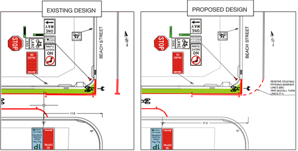
Accordingly, it is proposed that Turn Lines (T1) be installed in lieu of the existing 3m dividing (barrier) lines (two-way) to direct motorists away from cyclists travelling down the contraflow lane.
|
That:
1. The existing dividing (barrier) lines (two-way) and retro-reflective raised pavement markers (RRPM) on Beach Street, leading north away from Bream Street, be reduced in length by 3 metres as shown in design;
2. Turn line (T1) from existing dividing (barrier) line (two-way) on Beach Street to existing dividing (barrier) line on the northern side of Bream Street be installed, as shown in proposed design; and
3. The edge line (E1) on the southern side of Bream Street near Beach Street intersection, be relocated 5.4m west from its current position.
|
Responsible officer: Hong-Sanh Hua, Student Sustainable Transport Engineer
Traffic Committee
meeting
|
Traffic Committee Report No. TC89/20
|
|
Subject: Darley Road, Queens Park (C) |
|
Index code |
Trim Ref: |
Category |
Sub Category |
By |
AD |
|
2020.06.89 |
D03524853 |
Bicycle Matters |
Bicycle Safety |
TL |
Yes |
As reported to the June Traffic Committee meeting last year, Randwick Council has been working with the Centennial Park Trust and Waverley Council on a project to establish new walking and bike riding paths along the southern edge of Queens Park. This project proposes new sections of footpath and a separated cycleway. This project will significantly improve safety for children, pedestrians, bike riders, and motorists along Darley Road, between Carrington and York Roads.
Design funding was received from
Roads and Maritime Services (RMS) under their Active Transport Program. It is
being undertaken collaboratively with Waverley Council, and Centennial Park and
Moore Park Trust.
Details of this project can be seen at this website:
https://www.centennialparklands.com.au/About-us/Parklands-Projects/Queens-Park-Cycleway-Project
Detailed plans of the proposal have been provided to the Voting Members of the Traffic Committee.
|
That the proposed bike path and pedestrian paths, including relevant signage and linemarking (as indicated upon the detailed plans) are approved for installation.
|
Responsible officer: Tony Lehmann, Manager Integrated Transport
File Reference: F2010/00077
Traffic Committee
meeting
|
Traffic Committee Report No. TC90/20
|
|
Subject: Menin Road, Matraville (M) |
|
Index code |
Trim Ref: |
Category |
Sub Category |
By |
AD |
|
2020.06.90 |
D03857374 |
Road Safety |
Speed & Volume |
RM |
Yes |
Concerns have been raised about the volume and speed of motorists travelling along Menin Road, Matraville, south of Finucane Street. To ascertain the extent of the speeding issue a traffic survey was commissioned in May 2020, for a seven day period. The results of the survey are shown below:
Speed & Traffic Data - Menin Road, Matraville
|
DATA |
South of Finucane Crescent |
|
|
Northbound |
Southbound |
|
|
Weekly 50th%ile speed (km/h) |
43.1 |
42.2 |
|
Weekly 85th%ile speed (km/h) |
51.2 |
50.8 |
|
Five day AADT |
628 |
562 |
|
Seven day AADT |
599 |
523 |
From the above data it shows that the northbound and southbound speeds for Menin Road are very low.
Therefore, no action is deemed necessary, at this time.
|
That:
1. The results of the traffic survey for Menin Road, Matraville, undertaken in May 2020, be noted; and
2. The person raising concerns about this matter be informed of the results.
|
Responsible officer: Rasheeq Mahmood, Transport Technical Officer
File Reference: F2006/00101
Traffic Committee
meeting
|
Traffic Committee Report No. TC91/20
|
|
Subject: Moverly Road, Maroubra (M) |
|
Index code |
Trim Ref: |
Category |
Sub Category |
By |
AD |
|
2020.06.91 |
D03791747 |
Traffic Device |
Wombat Crossing |
TL |
Yes |
An upgrade of the existing school crossing in Moverly Road (just east of Ian Street) to a ‘Wombat Crossing’, has previously been approved by the Traffic Committee. However, due to the upcoming relocation of the school’s main driveway, Lycée Condorcet the International French School of Sydney, has applied to the Council for the relocation of the existing pedestrian facility.
The school has asked that this facility be relocated to the adjacent intersection of Moverly Road and Benvenue Street, in order to reduce significantly the pedestrian / vehicle conflict at their new main driveway.
Details of the proposed relocation will be tabled during the Traffic Committee meeting.
|
That the Traffic Committee consider the relocation of the Moverly Road pedestrian facility, from just east of the Ian Street intersection, to a position just east of the Benvenue Street intersection.
|
Responsible officer: Tony Lehmann, Manager Integrated Transport
File Reference: F2004/07238
Traffic Committee
meeting
|
Traffic Committee Report No. TC92/20
|
|
Subject: Minor Signage Items - Parking and Regulatory - June 2020 (C, H & M) |
|
Index code |
Trim Ref: |
Category |
Sub Category |
By |
AD |
|
2020.06.92 |
F2012/00032 |
Signage, Parking |
1P |
LQ |
Yes |
|
Item No |
Location |
Issue Request |
Recommend Approval? |
Comments |
|
TC92/20.1 |
Alison Road, COOGEE (C) (D03857935-LQ) (AD)
|
Install a 6m ‘1P, 8am-6pm” on the northern side of Alison Road, Coogee, outside no. 288. |
Yes |
To assist eligible mobility impaired resident park close to their property which is located on a steep hill. |
|
TC92/20.2 |
Bream Street, COOGEE (C) (D03873524-HH) (AD) |
Extend existing 10m length of No Stopping, on the southern side of Bream Street, west of Beach Street, Coogee, by 7 metres westerly. |
Yes |
Increase area of No Stopping to encourage better lane discipline upon Bream Street. |
|
TC92/20.3 |
Dudley Street, COOGEE (C) (D03782307-RM) (AD) |
Remove an existing Mobility Impaired Person’s Parking Space (MIPPS) at the frontage of 47-53 Dudley Street, Coogee NSW 2034. |
Yes |
Doctor’s surgery at 16 Asher Street, Coogee NSW 2034 no longer in business. |
|
TC92/20.4 |
Liguria Street, SOUTH COOGEE (C) (D03871719-RM) (AD) |
Install a 21m “No Parking, 6am-Midday, Friday Only” in front properties nos. 25 to 31 Liguria Street, South Coogee NSW 2035. |
Yes |
To facilitate waste collection on Fridays. |
|
TC92/20.5 |
Varna Street,
CLOVELLY (C) |
Remove the Mobility Impaired Person’s Parking Space (MIPPS) on the eastern side of Varna Street, Clovelly, in front of no.41. |
Yes |
MPS holder no longer requires space. |
|
TC92/20.6 |
Warner Avenue, CLOVELLY (C) (D03869157-LQ) (AD) |
Install ‘No Parking, 6am-12:30pm, Wednesday only’ restriction along the southern side of Warner Avenue and 7m of No Stopping on the southern side between the driveway of nos. 21 and 25 Shackle Avenue, Clovelly. |
Yes |
To assist Waste Service department in bin collection along a narrow lane and preventing parked vehicles from restricting the left turn from Northumberland Street. |
|
TC92/20.7 |
Baker Street, KENSINGTON (H) (D03879766-TL) (AD) |
Install 30m of No Parking on the northern side (between the driveways of no.29S (the electrical substation) and no.33) opposite Virginia Street, Kensington. |
Yes |
To prevent motorists from parking too close to existing double centrelines. |
|
TC92/20.8 |
Black Lion
Place, |
Install No Parking restriction across the stairway access, in the Black Lion Place cul-de-sac, adjacent to 97 Brompton Road, Kensington. |
Yes |
To prevent parked vehicles from obstructing the stairway access. |
|
TC92/20.9 |
Borrodale
Road, KINGSFORD (H) |
Extend the existing ‘1P 8am-8pm Permit Holders Excepted, Area KF2’ on the southern side of Borrodale Road, by 20m to cover the space immediate west of the driveway of 31 Borrodale Road, Kingsford. |
Yes |
To encourage higher parking turnover and prevent larger trade vehicles occupying the spaces for long periods of time from obstructing the driveway. |
|
TC92/20.10 |
Lenthall Street, KENSINGTON (H) (D03879766-TL) (AD) |
Install ‘Do Not Queue Across Any Intersection’ sign facing eastbound traffic, in Lenthall Street, at McDougall Street, Kensington. |
Yes |
To remind motorists that it is not legal to queue through an intersection. |
|
TC92/20.11 |
Lenthall Street, KENSINGTON (H) (D03879766-TL) (AD) |
Install ‘Do Not Queue Across Any Intersection’ sign facing eastbound traffic, in Lenthall Street, at Virginia Street, Kensington. |
Yes |
To remind motorists that it is not legal to queue through any intersection. |
|
TC92/20.12 |
Lenthall Street, KENSINGTON (H) (D03879766-TL) (AD) |
Install ‘Do Not Queue Across Any Intersection’ sign facing eastbound traffic, in Lenthall Street, at Milroy Avenue, Kensington. |
Yes |
To remind motorists that it is not legal to queue through any intersection. |
|
TC92/20.13 |
Bay Parade, MALABAR (M) (D03851820-LQ) (AD) |
Install a 24m ‘Bus Zone’ on the eastern side of Bay Parade for the bus zone opposite 5 Bay Parade, Malabar. |
Yes |
To prevent vehicles parking too close to the bus stop leaving insufficient draw in and draw out space for buses. Length of bus zone is as per advised by STA representative, Mr Bushara Gidiess. |
|
TC92/20.14 |
Hereward Street, MAROUBRA (M) (D03813180-LQ) (AD) |
Install a 3.5m ‘Motorcycle Parking Only’ zone on the eastern side of Hereward Street, in front of 19 Hereward Street, Maroubra. |
Yes |
To provide dedicated parking for motorcycles warranted by high demand. |
|
TC92/20.15 |
McKeon Street, MAROUBRA (M) (D03867150-LQ) (AD) |
Install a 5.5m Mobility Impaired Person’s Parking Space (MIPPS) on the southern side of McKeon Street, Maroubra, in front of no.19, immediately west of the driveway of no.17. |
Yes |
To assist nearby eligible mobility impaired resident of Alexander Street park close to their property. |
|
TC92/20.16 |
Norfolk Lane, MATRAVILLE (M) (D03877952-AL) (AD) |
Install 110m of ‘No Parking, 8am-9:30am and 2:30pm-4pm, School Days’ signage on the northern side of Norfolk Lane, along the boundary of the St Agnes’ Catholic Primary School on Norfolk Lane (School Address:509 Bunnerong Road, Matraville).
Install 75m of No Stopping signage on the southern side of Norfolk Lane, just opposite to the boundary of the St Agnes’ Catholic Primary School on Norfolk Lane (Scholl Address: 509 Bunnerong Road, Matraville). |
Yes |
For temporary arrangement of parents pick up and drop off on Norfolk Lane during COVID19 social distancing measure.
If proven to be successful and beneficial, Council and the School may seek to turn this into a more permanent measure.
|
|
That the recommendations listed in the Minor Signage items table, be approved.
|
Responsible officer: Lisa Qin, Student Transport Engineer; Hong-Sanh Hua, Student Sustainable Transport Engineer; Rasheeq Mahmood, Transport Technical Officer; Tony Lehmann, Manager Integrated Transport
File Reference: F2012/00032
Traffic Committee
meeting
|
Traffic Committee Report No. TC93/20
|
|
Subject: Works Zone - Installation of Signage - June 2020 (C) |
|
Index code |
Trim Ref; |
Category |
Sub Category |
By |
AD |
|
2020.06.93 |
D03882549 |
Signage, Parking |
Works Zone |
DA |
Y |
Construction sites often involve the use of trucks, cranes and other large vehicles. Without special parking provision, the positioning of such vehicles, close to these sites, can cause significant problems for local residents or businesses. It is for this reason that the Council requires the creation of Works Zones at construction sites. Once the project is completed the Works Zone is removed.
(NB: Due to the recent economic downturn associated with the global pandemic of coronavirus (COVID-19), Randwick City Council has received a number of requests from Works Zone applicants to suspend their Works Zone, until they are able to resume normal construction activities. In the table below Works Zones subject to such a temporary suspension are highlighted with the following notation: *Suspended due to special request.)
Accordingly, it is recommended that Works Zones be installed, or removed, at the locations detailed within the following table:
|
Item No. |
Street/ Suburb |
Side |
Length (m) |
Adjacent to (address) |
Existing Parking Controls |
Reference / Comments |
|
INSTALLATION |
||||||
|
1. |
Carrington Road, COOGEE (C) |
East |
8 |
175 Carrington Road |
½P, 8:30am-6:00pm |
LA/859/2020 D03882549-DA (AD) Install 8m “works zone, 7:00am-5:00pm, Mon-Friday, 8:00am-5:00pm Sat” at the frontage of 175 Carrington Road for four weeks. |
|
2. |
Mount Street, COOGEE (C) |
East |
13 |
48 Dudley Street, Coogee NSW 2034 |
Unrestricted |
WZ-307 D03880896-RM (AD) *Termination of suspension due to special request (AD) |
Works Zone installation conditions:
The following standard conditions may be referenced with regard to the installation of the Works Zones:
That:
a. The applicant be informed that if they intend to use traffic controllers for activities associated with the Works Zone, such activities must comply with a formal Traffic Control Plan (to be held on site following preparation by person/s with the appropriate TfNSW authorisation) and that any traffic controllers utilised must have current appropriate accreditation from TfNSW,
b. The Council be given authority to replace the Works Zone with a No Stopping zone if the operator (or their sub-contractors):
i. compromise pedestrian safety, or
ii. add significantly to traffic congestion in this area, or
iii. allow access/egress to/from the site which creates safety concerns or traffic flow delays, or
iv. does not ensure that the Council fees payable for this private use of the public road are met,
with the zone being reinstalled once the issue of concern is properly addressed;
c. The Council Rangers enforce the restriction; and
d. Authority be given to the Council to remove the Works Zone and reinstate the previous restrictions, when the applicant advises that it is no longer required.
|
That the Works Zones listed in the Works Zones Table be installed, as detailed.
|
Responsible officer: Rasheeq Mahmood, Transport Technical Officer; Dilruba Akhter, Transport Engineer
File Reference: F2007/00658
Traffic Committee
meeting
|
Traffic Committee Report No. TC94/20
|
|
Subject: Parking Control Signage at Intersections - No Stopping (C, H & M) |
|
Index code |
Trim Ref |
Category |
Sub Category |
By |
AD |
|
2020.06.94 |
D03859457 |
Signage, Parking |
No Stopping |
RM |
Yes |
The Council regularly receives requests for action to be taken with regard to vehicles being parked illegally at intersections. Such vehicles block sightlines to and from vulnerable pedestrians or bike riders. They can also obscure motorists’ views of approaching vehicles, and, they can create difficulties for fire engines, garbage trucks or other large service vehicles which need to access the neighbourhood.
To ensure compliance with the legally mandated parking prohibitions at intersections, it is recommended that No Stopping signage be installed as per the following table:
|
Item No. |
Street |
Suburb |
Side |
Dist. |
Direction |
Of |
Reference / Comments |
|
1. |
John Street (C) |
RANDWICK |
East |
24m |
South |
King Street |
D03859457-RM (AD) |
|
2. |
Kennedy Street (H) |
KINGSFORD |
West |
13m |
South |
Meeks Street |
D03867584-RM (AD) |
|
3. |
Baker Street (H) |
KENSINGTON |
South |
10m |
West |
Virginia Street |
D03879766-TL (AD) |
|
4. |
Virginia Street (H) |
KENSINGTON |
West |
10m |
South |
Baker Street |
D03879766-TL (AD) |
|
5. |
Moverly Road (M) |
MAROUBRA |
North and south |
10m |
East and west |
Garrett Street |
D03788376-DA (AD) |
|
6. |
Royal Street (M) |
MAROUBRA |
West |
10m |
North |
Mason Street |
D03870633-AL (AD) |
|
7. |
Royal Street (M) |
MAROUBRA |
East |
10m |
North |
Mason Street |
D03870633-AL (AD) |
|
8. |
Royal Street (M) |
MAROUBRA |
West |
10m |
South |
Mason Street |
D03870633-AL (AD) |
|
9. |
Royal Street (M) |
MAROUBRA |
East |
10m |
South |
Mason Street |
D03870633-AL (AD) |
|
10. |
Boyce Road (M) |
MAROUBRA |
North |
10m |
East |
Royal Street |
D03870633-AL (AD) |
|
11. |
Boyce Road (M) |
MAROUBRA |
South |
10m |
East |
Royal Street |
D03870633-AL (AD) |
|
12. |
Boyce Road (M) |
MAROUBRA |
North |
10m |
West |
Royal Street |
D03870633-AL (AD) |
|
13. |
Boyce Road (M) |
MAROUBRA |
South |
10m |
West |
Royal Street |
D03870633-AL (AD) |
|
14. |
Royal Street (M) |
MAROUBRA |
West |
10m |
South |
Boyce Road |
D03870633-AL (AD) |
|
15. |
Royal Street (M) |
MAROUBRA |
East |
10m |
South |
Boyce Road |
D03870633-AL (AD) |
(Reference NSW Road Rule 170 )
|
That the No Stopping signage listed in the Parking Control Signage at Intersections table be approved for installation.
|
Responsible officer: Alexander Lin, Transport Engineer; Dilruba Akhter, Transport Engineer; Rasheeq Mahmood, Transport Technical Officer; Tony Lehmann, Manager Integrated Transport
File Reference: F2008/00166
Traffic Committee
meeting
|
Traffic Committee Report No. TC95/20
|
|
Subject: Transport for NSW (formerly RMS) Funded Project Status - June 2020 (C & M) |
|
Index code |
Trim Ref: |
Category |
Sub Category |
By |
AD |
|
2020.06.95 |
F2016/00381 |
Road Safety |
Road Safety |
TL |
Yes |
The State Government provides regular funding under a number of programs for road safety, pedestrian and bike riding improvements. These funds are made available through Transport for NSW. Randwick Council has been successful with four projects for the 2019 / 2020 financial year. The total funds being provided to Randwick is approximately $180,000 and the following table provides a summary of these projects.
|
RMS Project Number |
PROJECT NAME |
Program Approved |
Approved 2019/20 Funding Allocation |
Type of Funding |
Monthly Status |
|
P.0042568 |
Dolphin Street at Arden Street, Coogee New pedestrian refuge |
Australian |
$20,165 |
100% |
Completed. |
|
P.0041933 |
St Pauls St & Perouse Rd, Randwick High Pedestrian Activity Area -40 km/h speed limit & new kerb nibs |
Safer
Local |
$28,290 |
100% |
Commencement of implementation is imminent. |
|
P.0041938 |
Arden
Street & Clovelly Road, Coogee |
Safer
Local |
$86,906 |
100% |
Commencement of construction is imminent. |
|
P.0033866 |
Anzac Parade & Forrest Street, Chifley Install raised island & additional stop signs |
Safer
Local |
$44,356 |
100% |
Completed. |
This table will be updated each month and will be reported upon at each Traffic Committee meeting.
|
That the information be received. |
Responsible officer: Tony Lehmann, Manager Integrated Transport