
MINUTES OF Traffic Committee MEETING of RANDWICK City COUNCIL
HELD ON Tuesday, 12 May 2020 AT 9:30am
IMPORTANT NOTICE: Given the COVID-19 Pandemic, many of Council's facilities, including the Customer Service Centre, the Libraries, the Des Renford Leisure Centre and various other Council facilities are closed to the public until further notice.
In order to protect the health of members of our community, the representatives of other agencies and Council staff members, the regular arrangements relating to the holding of the Committee cannot be continued. There will be no physical meetings of the Traffic Committee, until further notice.
This month’s Traffic Committee meeting was held as a video / remote meeting; using MS Teams.
Traffic Committee
- The following information is provided so that you may be aware of the structure and operation of the Randwick City Traffic Committee.
- The Randwick Traffic Committee is a Committee of Randwick City Council but not one set up under the Local Government Act.
- Council has been delegated certain powers, from Transport for NSW (formerly Roads and Maritime Services), with regard to traffic matters upon its local roads. A condition of this delegation is that Council must take into account the Traffic Committee recommendations.
- Recommendations in this document may either activate the formal delegation from Transport for NSW (TfNSW) to the Council, or not activate this delegation. Items which activate the delegation are indicated with the initials (AD) below the heading.
- There are four permanent members of the Traffic Committee, each of whom has a single vote only.
- The members are: the NSW Police Service, Transport for NSW (TNSW), the Local State Member of Parliament (for the location of the issue to be voted upon) and Randwick City Council.
- Randwick City Council welcomes the public to register to speak at its Traffic Committee on issues of concern.
- If the Local Member disagrees with any of the Traffic Committee recommendations, they may appeal to TfNSW or the Minister for Roads.
- If the Police or TfNSW disagrees with any of the Traffic Committee recommendations, or Council’s resolution on any Traffic Committee recommendation, they may lodge an appeal with the Sydney Regional Traffic Committee for determination. The appeal must be lodged in writing within 14 days of the notification to the members of Council’s decision on the recommendation.
- Any action relative to any issue under appeal must cease until the matter is determined.
- The Sydney Regional Traffic Committee is chaired by an independent chairperson and submissions and representations are welcomed from all interested parties.
Participants:
Mr Tony Lehmann Randwick City Council (Chairperson)
Mr Steven Nguyen Transport for NSW (TfNSW)
Sgt James Fisher Eastern Beaches Local Area Command (part meeting)
Cr Dylan Parker as representative for the Member for Maroubra
Mr Bushara Gidiess State Transit Authority
Mr Anthony Ryan Resident
Mr Alexander Lin, Ms Despina Kalavas, Ms Dilruba Akhter and Mr John Gill Randwick City Council
Apologies
|
|
Apologies were received from:
Representatives for the Member for Coogee and the Member for Heffron Mrs Evelyn Magistrale University of NSW (UNSW) |
Declarations of Pecuniary or Non-Pecuniary Interests
Nil.
Matters Arising from the Minutes OR from Council Resolution
Nil.
Traffic Committee Reports
|
|
|||||||||||||||||||||||||
|
|
Concerns have been raised by a resident regarding access to the garage at the rear of her property, accessed by Arden Lane, Clovelly. The current parking restrictions in the lane are as follows:
Existing Parking restrictions in north side of Arden Lane, Clovelly
Arden Lane is only 5.4m wide and the local parking practice is to park on the north side of Arden Lane; which can create garage access issues for some residents.
It is therefore proposed to extend the existing No Parking restrictions by another 6m westerly to improve local access conditions. The proposed parking restrictions on the north side of Arden Lane, west of Arden Street are as follows:
Proposed parking restrictions in north side of Arden Lane, Clovelly
Recommendation
That the proposed parking restrictions as presented in the above table be approved for installation.
|
|
|
|||||||||||||
|
|
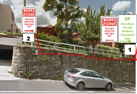
Council has received an application for the installation of a Works Zone on the eastern side of Arden Street in front of 159 Arden Street, Coogee. The developer is requesting a 20m Works Zone at the frontage of 159 Arden Street, Coogee, to facilitate the construction works. The duration of the Works Zone is for approximately 36 weeks. At present, parking is restricted at the frontage of the subject property; 2P, 8am-8pm, on the eastern side of Arden Street, Coogee. Upon site inspection it was suggested that the 20m works zone can be installed by replacing the existing 2P parking zone for the time of the construction period.
Recommendation:
|
|
|
|||||||||||||
|
|
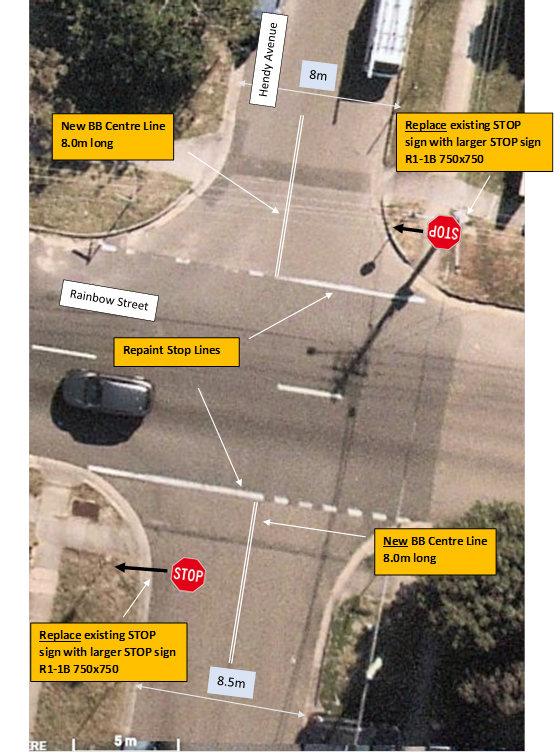
A resident has raised a concern regarding safety at the Hendy Avenue/Rainbow Street intersection, South Coogee. The resident has reported there are many collisions at this intersection due to vehicles failing to stop at the existing STOP signs on Hendy Avenue. Sight distance east and west of Hendy Avenue along Rainbow Street appears to be adequate taking into account southbound vehicles are travelling downhill and northbound vehicles are travelling uphill. Council’s crash database has recorded only four casualty incidents in the last five years, which may indicate many minor collisions are not being reported to the Police. It is proposed to upgrade the existing line marking in accordance with TfNSW (formerly RTA) Delineation-Section 6 (Feb 2010) Transverse Line Markings Section 6.4.1 Urban Areas, Figure 6.7 Transverse Line at a Stop Sign. This requires adding an 8m long BB double centreline extending back from the Stop line. It is also proposed to increase the size of the STOP signs on Hendy Avenue to R1-1B (750x750mm) from the existing STOP sign R1-1A, to improve visibility due to the approach grades. See attached plan.
Recommendation
That: 1. The Hendy Avenue Stop control linemarking at Rainbow Street, Randwick, be upgraded in accordance with TfNSW (formerly RTA) Delineation-Section 6 (Feb 2010) Transverse Line Markings Section 6.4.1 Urban Areas, Figure 6.7 Transverse Line at a Stop Sign; and 2. The size of the STOP signs on Hendy Avenue, be increased to R1-1B (750x750mm) from the existing R1-1A. |
|
|
|||||||||||||
|
|
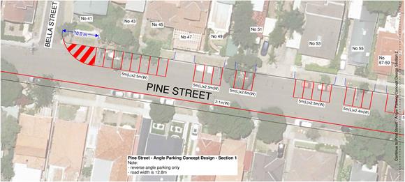
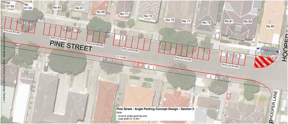
Following concerns having been raised with the Council an examination of angle parking has been undertaken with regard to Pine Street, Randwick. Local residents have expressed concerns that parking in the street has become more challenging. This is exacerbated when major sporting events and/or training is held within nearby Queens Park.
To increase parking supply and accommodate the high parking demand on Pine Street, it is proposed that the existing parallel parking on the northern side of Pine Street, between Bella Street and Hooper Lane, be converted into 90º reverse angle parking, as detailed in the attached plans.
Reverse angle parking concept design - 1 of 2
Reverse angle parking concept design - 2 of 2
Following the technical endorsement of the Traffic Committee, this matter would be referred to the community for consultation. Subsequently the matter would be reported back to the Traffic Committee for final approval.
Recommendation
That, the proposed 90º angle parking, rear to kerb, arrangements on the northern side of Pine Street, Randwick, as detailed in the attached plans, are endorsed for community consultation.
|
|
|
|||||||||||||
|
|
Concerns have been raised by a local resident about the safety of the intersection of St Marks Road and Alison Road, Randwick. The most recent five years’ of crash data (June 2014 to June 2019) indicates that there have been two reported injury crashes at this intersection. One of the crashes involved a pedestrian.
This intersection is typified by both, a vertical and a horizontal curve. Sight lines for emerging St Marks Road motorists are, as a result, compromised. Currently, there is no Give Way control in St Marks Road, at Alison Road.
Given the crash history and the restricted sight distance for the St Marks Road motorists, it is considered that a ‘STOP’ control in association with the appropriate line marking be installed on St Marks Road, at Alison Road.
Recommendation
That a ‘’STOP’’ control in association with appropriate line marking be installed in St Marks Road at Alison Road, Randwick.
|
|
|
|||||||||||||||||||||||||||||||||||||||||||||||||||||||||||||||||||||||||||||||||||||||||||||||||||||||||||||||||||||||||||||||||||||||||||||||||||||||||||||||||||||||||||||||||||||||||||||||||||||||||||||||||||||||||||||||
|
|
Mr Bushara Gidiess, Traffic and Services Manager, Eastern Region, State Transit Authority, has asked that a number of bus stops within Maroubra, Matraville, Chifley and Little Bay, be signposted as Bus Zones.
Below are the locations located along Anzac Parade.
Recommendation
That the bus zones submitted by the State Transit Authority be approved for installation along Anzac Parade, in the suburbs of Maroubra, Matraville, Chifley and Little Bay.
|
|
|
|||||||||||||
|
|
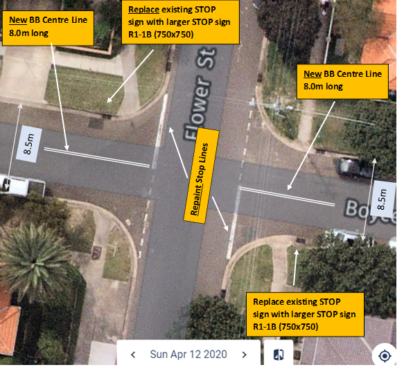
Concerns have been raised about reported collisions at the intersection of Boyce Road and Flower Street, Maroubra, reportedly due to vehicles failing to stop at the existing STOP signs on Boyce Road. Sight distance east and west of Boyce Road along Flower Street appears to be adequate.
Council’s crash database has recorded only two collisions in the last five years, which may indicate that many minor incidents are not being reported to the Police.
Line marking for the STOP signs on Boyce Road do not conform to the current standard. It is proposed to upgrade the line marking in accordance with TfNSW (formerly RTA) Delineation-Section 6 (Feb 2010) Transverse Line Markings Section 6.4.1 Urban Areas, Figure 6.7 Transverse Line at a Stop Sign. This requires adding an 8m long BB double centreline extending back from the Stop line.
It is also proposed to increase the size of the STOP signs on Boyce Road to R1-1B (750x750mm) from the existing STOP sign R1-1A, to improve visibility.
Recommendation
That:
1. the linemarking at the Boyce Road / Flower Street intersection, be upgraded in accordance with TfNSW (formerly RTA) Delineation-Section 6 (Feb 2010) Transverse Line Markings Section 6.4.1 Urban Areas, Figure 6.7 Transverse Line at a Stop Sign; and
2. The Boyce Road STOP signs, at the intersection with Flower Street, Maroubra, be increased in size to the R1-1B (750x750mm) from the existing R1-1A.
|
|
|
|||||||||||||
|
|
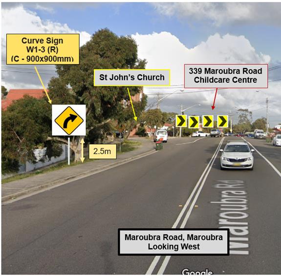
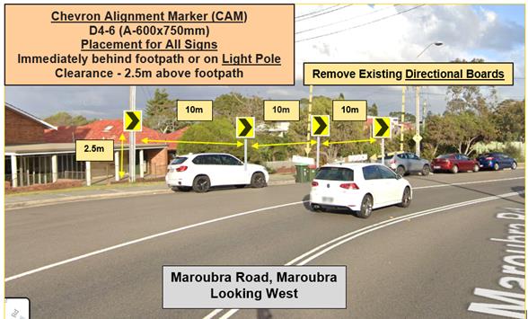
The Guardian Childcare and Education Centre at 339 Maroubra Road, Maroubra, reported to Council that ‘they frequently have car crashes along this road. Our parents have raised many concerns with us about the above. Can you please look into the signage around this area?’ Following the raised concern by Childcare Centre, an analysis of the most recently available five years (60 months) crash data was undertaken for Maroubra Road curve, approximately 140m east of Flower Street, Maroubra. This analysis revealed that, there were three recorded collisions in the five year period from July, 2014, to June, 2019. The Childcare Centre sent a photo of a recent collision showing that a car had collided with parked vehicles. To improve the visibility of the bend on Maroubra Road, it is proposed to remove the old and damaged curve indicator boards and replace them with an advanced Curve Sign and four Chevron Alignment Markers (CAMs) as shown in the attached sketch. It is proposed to raise the CAMS to be 2.5m above the footpath so they can be seen above cars parked in front.
Recommendation
That approval is given to the installation of:
1. An advance Curve Sign (W1-3) immediately behind the footpath and at a height clearance of 2.5m above the footpath; and
2. Four Chevron Alignment Markers (CAMs) placed immediately behind the footpath, at a height of 2.5m, in the line of sight of approaching motorists, approximately 10m apart; outside St John’s Church, 339A Maroubra Road, Maroubra.
|
|
|
|||||||||||||
|
|
Council’s Waste Services Department recently sought clarification on the possibility/logistics of installing No U-Turn signs, for west bound motorists, at the intersection of Kelly Lane and Perry Street, Matraville, for the duration of the COVID-19 Pandemic.
They advised that they had encountered a significant increase in visits to the Council’s Perry Street Recycling Centre and that, with restricted access protocols implemented to limit visitors on site for the safety of both staff and visitors, there were numerous times where the queue on Perry Street was quite long and that motorists who continued to make U-turns to access the centre were regularly blocking Perry Street completely.
Arising from an internal Workplace Health and Safety Risk assessment was a recommendation to temporarily restrict U-Turns at this minor intersection.
Although imposition of such a control would normally require consideration by the Traffic Committee, the Council implemented No U-Turn signage, on urgent public (and staff) safety grounds, in the week ending 24th April, 2020.
A retrospective Traffic Management Plan will be provided to Transport for NSW, prior to the Traffic Committee meeting.
Recommendation
That:
1. It be noted that Randwick Council installed No U-Turn signs at the intersection of Kelly Lane and Perry Street on urgent public (and staff) safety grounds;
2. It be further noted that possible retention of these signs will be reviewed once it is determined that the COVID-19 Pandemic is over; and
3. The Council forward to Transport for NSW, an appropriate Traffic Management Plan detailing the No U-Turn control installed urgently in Perry Street, at Kelly Lane, Matraville.
|
|
|
|||||||||||||||||||||||||||||||||||||||||||||||||||||||||||||||||||||||||
|
|
Recommendation
That the recommendations listed in the Minor Signage items table, be approved.
|
|
|
|||||||||||||||||||||||||||||||||||||||||||||||||||||||||||||||||||||
|
|
Construction sites often involve the use of trucks, cranes and other large vehicles. Without special parking provision, the positioning of such vehicles, close to these sites, can cause significant problems for local residents or businesses. It is for this reason that the Council requires the creation of Works Zones at construction sites. Once the project is completed the Works Zone is removed.
(NB: Due to the recent economic downturn associated with the global pandemic of coronavirus (COVID-19), Randwick City Council has received a number of requests from Works Zone applicants to suspend their Works Zone, until they are able to resume normal construction activities. In the table below Works Zones subject to such a temporary suspension are highlighted with the following notation: *Suspended due to special request.)
Accordingly, it is recommended that Works Zones be installed, or removed, at the locations detailed within the following table:
Recommendation
That the Works Zones listed in the Works Zones Table, be installed or removed, as detailed.
Works Zone installation conditions:
The following standard conditions may be referenced with regard to the installation of the Works Zones:
That: a. The applicant be informed that if they intend to use traffic controllers for activities associated with the Works Zone, such activities must comply with a formal Traffic Control Plan (to be held on site following preparation by person/s with the appropriate TfNSW authorisation) and that any traffic controllers utilised must have current appropriate accreditation from TfNSW,
b. The Council be given authority to replace the Works Zone with a No Stopping zone if the operator (or their sub-contractors): i. compromise pedestrian safety, or ii. add significantly to traffic congestion in this area, or iii. allow access/egress to/from the site which creates safety concerns or traffic flow delays, or iv. does not ensure that the Council fees payable for this private use of the public road are met, with the zone being reinstalled once the issue of concern is properly addressed;
c. The Council Rangers enforce the restriction; and
d. Authority be given to the Council to remove the Works Zone and reinstate the previous restrictions, when the applicant advises that it is no longer required.
|
||||||||||||||||||||||||||||||||||||||||||||||||||||||||||||||||||||
|
|
|||||||||||||||||||||||||||||||||||||||||||||||||||||
|
|
The Council regularly receives requests for action to be taken with regard to vehicles being parked illegally at intersections. Such vehicles block sightlines to and from vulnerable pedestrians or bike riders. They can also obscure motorists’ views of approaching vehicles, and, they can create difficulties for fire engines, garbage trucks or other large service vehicles which need to access the neighbourhood.
To ensure compliance with the legally mandated parking prohibitions at intersections, it is recommended that No Stopping signage be installed as per the following table:
(Reference NSW Road Rule 170 )
Recommendation
That the No Stopping signage listed in the Parking Control Signage at Intersections table be approved for installation. |
Urgent Matters or Matters for Future Investigation
|
|
|||||||||||||
|
|
Following discussions relating to TR80/20, the representative for the Member for Maroubra, Cr Dylan Parker, asked about the possibility of introducing double centrelines in Flower Street on both the northern and southern approaches to Maroubra Road. Mr Lehmann advised that this proposal would be investigated, and if appropriate, would be reported to a future Traffic Committee meeting.
Recommendation
That the possibility of introducing double centrelines in Flower Street on both the northern and southern approaches to Maroubra Road, be investigated and, if appropriate, reported upon at a future Traffic Committee meeting.
|
|
|
|||||||||||||
|
|
The representative for the Member for Maroubra, Cr Dylan Parker, raised the issue of the conspicuity of the pedestrian crossing signage in Maroubra Road at the Flower Street intersection. In particular, he advised the Committee members that when the sun is setting it is often difficult to discern pedestrians, the pedestrian crossing markings and signage. Mr Lehmann commented that it may be difficult to introduce measures to address this issue, however, he agreed that this issue would be investigated, and if appropriate, would be reported to a future Traffic Committee meeting.
Recommendation
That the issue of the conspicuity of the pedestrian crossing road markings and signage in Maroubra Road, at the Flower Street intersection be investigated, and if appropriate, be reported to a future Traffic Committee meeting.
|
The meeting closed at 9.50am.