
MINUTES OF Traffic Committee MEETING of RANDWICK City COUNCIL
HELD ON Tuesday, 10 March 2020 AT 9:30am
Traffic Committee
- The following information is provided so that you may be aware of the structure and operation of the Randwick City Traffic Committee.
- The Randwick Traffic Committee is a Committee of Randwick City Council but not one set up under the Local Government Act.
- Council has been delegated certain powers, from Roads and Maritime Services (RMS), with regard to traffic matters upon its local roads. A condition of this delegation is that Council must take into account the Traffic Committee recommendations.
- Recommendations in this document may either activate the formal delegation from RMS to the Council, or not activate this delegation. Items which activate the delegation are indicated with the initials (AD) below the heading.
- There are four permanent members of the Traffic Committee, each of whom has a single vote only.
- The members are: the NSW Police Service, Roads and Maritime Services (RMS), the Local State Member of Parliament (for the location of the issue to be voted upon) and Randwick City Council.
- Randwick City Council welcomes the public to attend and speak at its Traffic Committee on issues of concern.
- If the Local Member disagrees with any of the Traffic Committee recommendations, they may appeal to the RMS or the Minister for Roads.
- If the Police or the RMS disagrees with any of the Traffic Committee recommendations, or Council’s resolution on any Traffic Committee recommendation, they may lodge an appeal with the Sydney Regional Traffic Committee for determination. The appeal must be lodged in writing within 14 days of the notification to the members of Council’s decision on the recommendation.
- Any action relative to any issue under appeal must cease until the matter is determined.
- The Sydney Regional Traffic Committee is chaired by an independent chairperson and submissions and representations are welcomed from all interested parties.
Attendees:
Mr Tony Lehmann Randwick City Council - Chairperson
Sgt James Fisher Eastern Beaches Local Area Command
Senior Constable Corrine Dawes Eastern Beaches Local Area Command
Mr Steven Nguyen Transport for NSW (TfNSW) *
Other Attendees:
Mr Bushara Gidiess Sydney Buses (STA)
Ms Evelyn Magistrale UNSW
Ms Neridah Tanner Resident
Ms Emanuela Mattana Resident
Mr Paul Chilcott Resident
Mrs Kerrie Gibbs Resident
Mr Anthony Ryan Resident
Mr Brian Smith Resident
Mr Steve Langan-Stark Resident
Ms Despina Kalavas and Mr Alexander Lin - RCC
Apologies
|
|
Mr Jeremy Phillips-Yelland Representative for Member for Coogee Ms Catherine Wade Representative for Member for Heffron Ms Lisa Williams Representative for Member for Maroubra |
Traffic Committee Reports
|
|
|
|
|
At the December 2019 Traffic Committee meeting the following approval was given to extend the parking restrictions for the existing 22m long parking zone on the northern side of Coogee Bay Road in front of 140-140A Coogee Bay Road;
That the hours of operation of the parking controls on the northern side of Coogee Bay Road, between points 10m and 32m west of Mount Lane, be extended to 8pm such that they now become 2P, 8:30am-8:00pm, Mon-Sun.
However a local business owner has now requested that the hours of operation be extended to 8pm every day inclusive of public holidays.
Recommendation
That the hours of operation of the parking controls on the northern side of Coogee Bay Road, between points 10m and 32m west of Mount Lane, be extended to 8pm such that they now become 2P, 8:30am-8:00pm. |
|
|
||||||||||||||||
|
|
Following receipt of a resident’s concerns, about the speed of vehicles along Alison Road, a traffic survey was commissioned in February 2020 for a seven-day period, between Pauling Avenue and Mount Street, outside 293 Alison Road. The results of the survey are shown below:
Speed & Traffic Data - Alison Road, Randwick (between Pauling Avenue and Mount Street)
This traffic survey indicates that the speeds along Alison Road are relatively low. Therefore, no action is deemed necessary, at this time.
Mr Chilcott (resident) asked whether more detailed information relating to the traffic counts could be forwarded to him. He raised concerns about the increased volume of traffic in the street, compared to previous years. Mr Lehmann agreed to forward to Mr Chilcott a detailed copy of the traffic count data.
Recommendation
That:
1. The results of the traffic survey for Alison Road, Randwick, undertaken in February 2020, be noted; and
2. The person raising concerns about this matter be informed of the results.
|
|
|
|||||||||||||||||||||||||||||||||||||||||||||||||||
|
|
The results of the surveys are shown below:
Site 1 - Speed & Traffic Data - Asturias Avenue, South Coogee (between Georgic Place and Fairsky Street)
Site 2 - Speed & Traffic Data - Asturias Avenue, South Coogee (between Fairsky Street and Macdili Place)
Site 3 - Speed & Traffic Data - Fairsky Street, South Coogee (between Georgic Place and Asturias Avenue)
Site 4 - Speed & Traffic Data – Fairsky Street, South Coogee (between Macdili Place and Asturias Avenue)
This traffic surveys indicates that the speeds along Asturias Avenue and Fairsky Street are very low. Therefore, no action is deemed necessary, at this time.
Recommendation
That:
1. The results of the traffic surveys for Asturias Avenue and Fairsky Street, South Coogee, undertaken in February 2020, be noted; and
2. The person raising concerns about this matter be informed of the results. |
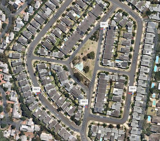 Following
receipt of a resident’s concern, about the speed of vehicles along
Asturias Avenue and Fairsky Street, traffic surveys were commissioned in
February 2020 for a seven-day period, in four different sites, as shown in
the following plan.
Following
receipt of a resident’s concern, about the speed of vehicles along
Asturias Avenue and Fairsky Street, traffic surveys were commissioned in
February 2020 for a seven-day period, in four different sites, as shown in
the following plan.
|
|
|
|
|
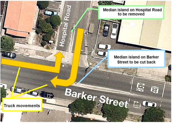
The development of the Prince of Wales Hospital - Addition to the Acute Services Building includes the closure of Hospital Road, at its intersection with High Street, Randwick. With the closure of the northern end of Hospital Road, the existing carpark entry/exit points can only be accessed via Barker Street to the south.
The intersection currently has a median island on Barker Street, east of Hospital Road in order to prevent vehicles from turning right. The median island will be required to be cut back in order to allow larger trucks to turn right from Hospital Road to Barker Street. The current median island in Hospital Road will need to be removed to allow the left turn movements from Barker Street into Hospital Road. Accordingly, appropriate signage will need to be installed at the intersection in order to advise motorists that the right turns out from Hospital Road will only be permitted for trucks over 9m.
Recommendation
That:
1. A “No Right Turn - Vehicles Over 9m Excepted” control be imposed upon southbound Hospital Road motorists at Barker Street, provided that a Traffic Management Plan detailing this proposal is approved by Transport for NSW for; and
2. A detailed design be prepared by the developers and referred to the next Traffic Committee for approval. |
|
|
||||
|
|
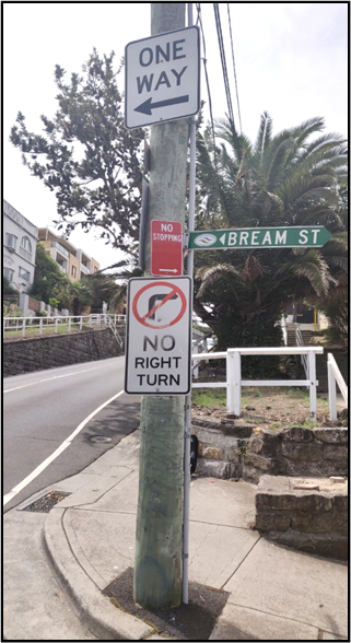
Bream Street, Coogee between Arden Street and Beach Street has an approved contraflow bike path underway involving signage modifications. A ‘One Way’ and ‘No Right Turn’ sign currently exists on the south side of ELP SY12778. In order to reduce signage clutter and improve sign visibility, it is proposed that the existing ‘No Right Turn’ on the south side of ELP SY12778 be removed in accordance with AS1742.2 - 2009.
Clause 2.8.5. Sign R2-6 (No Right Turn): “This sign shall not be used to indicate that a street or road is one-way. The ONE WAY repeater sign (R2-17) (see clause 4.13.3), is used for this purpose.” Clause 2.8.2. “Where a one-way roadway terminates at an intersection, NO ENTRY signs (R2-4) are required to prevent movements in the prohibited direction)”
Given that AS1742.2 does not specify that sign R2-6 needs to be installed in conjunction with sign R2-17, it is proposed that the ‘No Right Turn’ be removed such that the existing ‘One Way’ sign can be installed to meet minimum height regulations (2.2m) and to improve visibility for both cyclists and
motorists.
Recommendation
That the ‘No Right Turn’ control be removed from the south side of ELP SY12778, located on the north side of Bream Street, Coogee, at the Arden Street, Coogee, intersection.
|
|
|
|
|
|
Concerns have been raised by some local residents that there have been a number of near misses at the intersection of Chapel Street and St Marks Road, Randwick. Investigation of the recorded crashes at this intersection showed that there have been two crashes in the last eight years (2010-2018). Chapel Street meets St Marks Road at an acute angle; resulting in a very wide intersection. Given the layout of the intersection, it is likely that some motorists may get confused about the T-intersection Give Way rule. Therefore, it is recommended that regulatory ‘Give Way’ signage and associated linemarking delineation, be installed in Chapel Street, at St Marks Road, Randwick.
Mr Nguyen (TfNSW) sought clarification as to Council’s intention regarding installation of No Stopping signage at this intersection. Mr Lehmann responded by advising that a further report would come back to the Traffic Committee regarding the possible installation of No Stopping signage at this intersection.
Recommendation
That existing priority control at the intersection of Chapel Street and St Marks Road, Randwick, be clarified with the introduction of Give Way signage and linemarking (NB. For clarity - St Marks Road motorists will have priority over Chapel Street motorists).
|
|
|
|
|
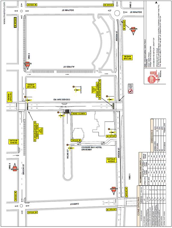
For many months the Coogee Bay Road business community has been subject to traffic and parking obstructions due to the construction activity associated with the streetscape upgrade.
Consideration is being given to the holding of a local community event in support of the local Coogee Bay Road businesses. This event will be the subject of a separate report to the Council.
If such an event is endorsed by the Council, it would likely involve the temporary closure of Coogee Bay Road, between Arden Street and Brook Street, from 8am to 2pm on Saturday, 2 May, 2020.
As this possible temporary road closure involves signalised intersections, both a Traffic Management Plan (TMP) and a Traffic Control Plan (TCP) have been forwarded to TfNSW for consideration.
Note that access to and from Vicar Street can be maintained by utilising the wide driveway of the Coogee Bay Hotel.
Recommendation
That, if the Council endorses the holding of the event, and provided the Traffic Control Plan is endorsed by TfNSW: Coogee Bay Road, between Arden Street and Brook Street, be temporarily closed from 8am until 2pm on Saturday, 2 May 2020.
|
|
|
||||||||||||||||||||||||||||||||||||||||||||
|
|
At the June 2019 Traffic Committee meeting, a six-month trial of a 4P, 1pm-6pm, Wednesday parking control along the north side of Darley Road, adjacent to Centennial Park and Queens Park, was endorsed Before and after site surveys have been undertaken to assess the outcomes in Darley Road and some surrounding streets.
The following information details the results of the parking audits undertaken before and after the installation of the signs on 23 August, 2019.
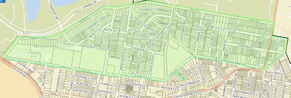
1. Survey Area
Audits of trucks, vans, boats, and other trailers were undertaken for the area bounded by Darley Road, King Street, Stanley Street, Market Street, Gilderthorpe Avenue, Albion Street, Pine Street and Carrington Road, as shown by the map below.
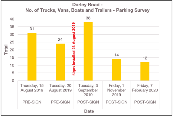
2. Darley Road Surveys
The results of the Darley Road parking surveys before and after installation of the subject signs are detailed in the following table:
No. of Trucks, Vans, Boats and Trailers – Darley Road, Randwick
Overall, the data shows that there has been a significant reduction in the number of parked trucks, vans, boats and trailers on Darley Road, Randwick, between pre-installation to post-installation of signs.
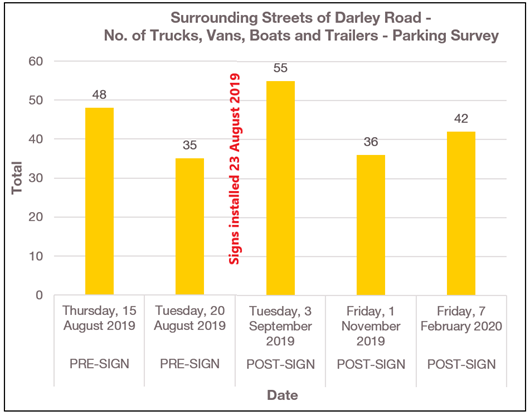
3. Darley Road Surrounding Streets Surveys
The results of the parking surveys undertaken within streets surrounding Darley Road, before and after installation of the subject signs are detailed within the following table:
No. of Trucks, Vans, Boats and Trailers – Surrounding Streets of Darley Road, Randwick
Overall, the results indicate that there has been no impacts upon the surrounding streets.
4. Conclusion and Recommendation
From the data collected above, it is evident that there is a reduction in the numbers of parked trucks, vans, boats and trailers on Darley Road, with no adverse effect to the surrounding streets.
As the data reveals that the parking controls have been effective, with no adverse effects on surrounding streets, it is concluded that these parking controls should be retained.
Mr Chilcott (resident) sought clarification with regard to the proposed notification of Darley Road residents. Mr Lehmann described the length of Darley Road to which the parking changes were implemented and it was agreed that the Recommendation be endorsed.
Recommendation
That:
1. The existing “4P, 1pm-6pm, Wednesday” parking restrictions be retained on the northern side of Darley Road, between Alison Road and Carrington Road, Randwick; and
2. Darley Road residents be informed of the outcomes of the trial and be advised that the Committee has recommended that the parking controls on the north side of Darley Road, be retained. |
|
|
||||||||||||||||||||||||||||||
|
|
Concerns have been raised about the volume and speed of vehicles in Govett Lane, Randwick. To ascertain the extent of the speeding issue a traffic survey was commissioned in February 2020, for a seven day period. The results of the survey are shown below:
Speed & Traffic Data - Govett Lane, Randwick
Given that the vehicular speeds are very low, no action is recommended.
Recommendation
That:
1. The results of the traffic survey for Govett Lane, Randwick, undertaken in February 2020, be noted; and
2. The resident raising concerns about this matter be informed of the results.
|
|||||||||||||||||||||||||||||
|
|
||||||||||||||||||
|
|
Concerns have been raised about the volume and speed of vehicles in Monmouth Street, Randwick. To ascertain the extent of the speeding issue a traffic survey was commissioned in February 2020, for a seven day period. The results of the survey are shown below:
Speed & Traffic Data - Monmouth Street, Randwick
From the above data it shows that the northbound and southbound speeds for Monmouth Street are very low.
Therefore, no action is deemed necessary, at this time.
Recommendation
That: 1. The results of the traffic survey for Monmouth Street, Randwick, undertaken in late November 2019 to early December 2019, be noted; and
2. The person raising concerns about this matter be informed of the results.
|
|||||||||||||||||
|
|
|||||||||||||||||||||||||||||||||||||
|
|
Following resident concerns being raised about car parking availability and turn over in the area, the Council surveyed Randwick residents (within the RA5 resident parking area, see following map), in February 2020 in order to seek the opinion of the residents in relation to the existing timed resident parking restrictions.
In February 2020, the Council distributed surveys to some 130 residents within the RA5 resident parking area. The residents received a letter advising them of our online survey. Residents could respond to the survey by visiting the Council’s “Your Say” Randwick website.
Some 26 local residents responded. The following data relates to the 26 responses from residents of the proposed area.
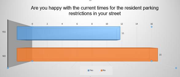
Respondents were asked questions about the current signposted resident parking restrictions and if the residents were satisfied with the current times and duration and if they could provide feedback on other proposed times.
Overall, 58% of respondents were not in favour of the current resident parking times, compared with 42% who were in favour of the current restrictions.
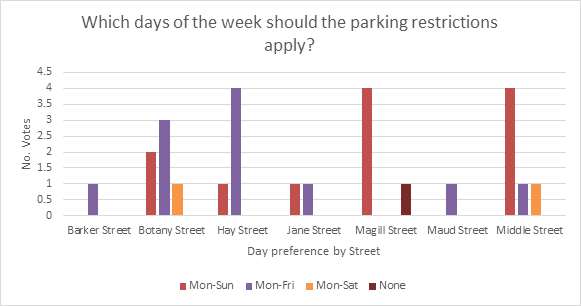
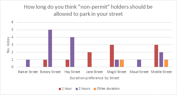
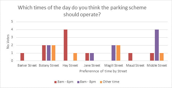
All respondents were asked about their experiences accessing on street parking and what days and times of the day should the parking scheme operate.
The analysis of voting preferences in relation to the preferred days and duration per street have been presented in the following charts:
Recommendation
That:
1. the following changes to parking controls be undertaken:
a) Amend the current “1P 8am-6pm, Mon-Fri, Permit Holders Excepted” at the northern side of Middle Street, Randwick, between properties No.84 and No.90 to “1P 8am-6pm, Mon-Sun, Permit Holders Excepted, Area RA5”;
b) Amend the current “1P 8am-6pm, Mon-Fri, Permit Holders Excepted” at the southern side of Middle Street, Randwick, between properties No.117 and No.109-111 to “1P 8am-6pm, Mon-Sun, Permit Holders Excepted, Area RA5”; and
2. The affected residents be notified about the proposed parking changes.
|
||||||||||||||||||||||||||||||||||||
|
|
||||||||||||||||
|
|
Following receipt of resident concern, about the speed of vehicles along Roscrea Avenue, a traffic survey was commissioned in February 2020 for a seven-day period, between Gilderthorpe Avenue and Frenchmans Road, outside 7 Roscrea Avenue. The results of the survey are shown below:
Speed & Traffic Data – Roscrea Avenue, Randwick (between Gilderthorpe Avenue and Frenchmans Road)
This traffic survey indicates that the speeds along Roscrea Avenue are relatively low. Therefore, no action is deemed necessary, at this time.
Recommendation
That:
1. The results of the traffic survey for Roscrea Avenue, Randwick, undertaken in February 2020, be noted; and
2. The person raising concerns about this matter be informed of the results.
|
|
|
|
|
|
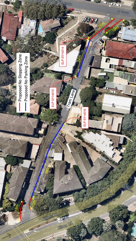
That the installation of the parking restrictions, as detailed in the attached plan, be approved for Tram Lane, between Alison Road and Church Street, Randwick.
|
|
|
||||||||||||||||
|
|
Following receipt of resident concern, about the speed of vehicles along Byng Street, a traffic survey was commissioned in February 2020 for a seven-day period, between Byng Lane and Beatty Street, outside 9 Byng Street. The results of the survey are shown below:
Speed & Traffic Data - Byng Street, Maroubra (between Byng Lane and Beatty Street)
This traffic survey indicates that the speeds along Byng Street are relatively low. Therefore, no action is deemed necessary, at this time.
Recommendation
That:
1. The results of the traffic survey for Byng Street, Maroubra, undertaken in February 2020, be noted; and
2. The person raising concerns about this matter be informed of the results.
|
|
|
||||||||||||||||||||||||||||||||||||||||||||||||||||||||||||||||||||||||||||||||||||||||||||||||||||||||||||||||||||||||||||||||||||||||||||||||||
|
|
The following Minor Signage matters were listed for the Committee’s consideration.
With regard to Item TR38/20.7 - Dangar Street and Wentworth Street, Randwick, it was agreed that:
1. the proposed traffic control be amended such that it applies to buses only; and
2. it be noted that the No Buses control proposed, would not apply if there was an emergency in the area which re-directed buses to use Dangar Street or Wentworth Street.
Recommendation
That:
1. the Recommendations listed in the Minor Signage items table, be approved apart from Item TR38/20.7 - Dangar Street and Wentworth Street, Randwick; and
2. with regard to Item TR38/20.7; Dangar Street and Wentworth Street, Randwick, have a No Buses, Vehicles Over 4.5t GVM, 9pm-6am, control imposed upon each street. |
|
|
||||||||||||||||||||||||||||||||||||||||||||||||||
|
|
Construction sites often involve the use of trucks, cranes and other large vehicles. Without special parking provision, the positioning of such vehicles, close to these sites, can cause significant problems for local residents or businesses. It is for this reason that the Council requires the creation of Works Zones at major construction sites. Once the project is completed the Works Zone is removed.
Accordingly, it is recommended that Works Zones be installed, or removed, at the locations detailed within the following table:
Recommendation
That the Works Zones listed in the Works Zones Table, be installed or removed, as detailed.
Works Zone Installation Conditions
The following standard conditions may be referenced with regard to the installation of the Works Zones:
That: a. The applicant be informed that if they intend to use traffic controllers for activities associated with the Works Zone, such activities must comply with a formal Traffic Control Plan (to be held on site following preparation by person/s with the appropriate TfNSW authorisation) and that any traffic controllers utilised must have current appropriate accreditation from TfNSW,
b. The Council be given authority to replace the Works Zone with a No Stopping zone if the operator (or their sub-contractors): i. compromise pedestrian safety, or ii. add significantly to traffic congestion in this area, or iii. allow access/egress to/from the site which creates safety concerns or traffic flow delays, or iv. does not ensure that the Council fees payable for this private use of the public road are met, with the zone being reinstalled once the issue of concern is properly addressed;
c. The Council Rangers enforce the restriction; and
d. Authority be given to the Council to remove the Works Zone and reinstate the previous restrictions, when the applicant advises that it is no longer required.
|
|||||||||||||||||||||||||||||||||||||||||||||||||
|
|
|||||||||||||||||
|
|
Parking Control Signage At Intersections (AD)
The Council regularly receives requests for action to be taken with regard to vehicles being parked illegally at intersections. Such vehicles block sightlines to and from vulnerable pedestrians or bike riders. They can also obscure motorists’ views of approaching vehicles, and, they can create difficulties for fire engines, garbage trucks or other large service vehicles which need to access the neighbourhood.
To ensure compliance with the legally mandated parking prohibitions at intersections, it is recommended that No Stopping signage be installed as per the following table:
(Reference NSW Road Rule 170 )
Recommendation
That the No Stopping signage listed in the Parking Control Signage at Intersections table be approved for installation. |
|
|
||||||||||||||||||||||||||||||||||||
|
|
The State Government provides regular funding under a number of programs for road safety, pedestrian and bike riding improvements. These funds are made available through Transport for NSW (TfNSW)*. Randwick City Council has been successful with eight projects for the 2019 / 2020 financial year. The total funds being provided to Randwick is approximately $180,000 and the following table provides a summary of these projects.
Recommendation
That the information be received.
|
Urgent Matters or Matters for Further Investigation
|
|
Mrs Kerrie Gibbs (resident) sought an update on the progress with regard to her Howard Street concerns.
Mr Lehmann advised that the task of designing the proposed new pedestrian refuge in Howard Street, near Lee Street, is being referred to consultant designers. He advised that he expects that an early design would be returned to the Council within a few weeks.
Recommendation
That the information be received. |
The meeting closed at 10.38 am.