Planning Committee Meeting
BUSINESS PAPER
Tuesday 12 April 2016
Administrative Centre 30 Frances Street Randwick 2031
Telephone: 1300 722 542
Fax: 02 9319 1510
Planning Committee Meeting
BUSINESS PAPER
Tuesday 12 April 2016
Administrative Centre 30 Frances Street Randwick 2031
Telephone: 1300 722 542
Fax: 02 9319 1510
Planning Committee 12 April 2016

Notice is hereby given that a Planning Committee Meeting of the Council of the City of Randwick will be held in the Council Chamber, First Floor, 90 Avoca Street Randwick on Tuesday, 12 April 2016 at 6:00 p.m.
Committee Members: The Mayor N D’Souza, Andrews, Belleli, Bowen, Garcia, Matson, Moore, Nash, Neilson, Roberts (Deputy Chairperson), Seng, Shurey, Smith, Stavrinos (Chairperson) and Stevenson
Quorum: Eight (8) members
NOTE: At the Extraordinary Meeting held on 28 September 2004, the Council resolved that the Planning Committee whose membership consists of all members of the Council be constituted as a committee with full delegation to determine matters on the agenda.
Apologies/Granting of Leave of Absences
Confirmation of the Minutes
Planning Committee Meeting - 8 March 2016
Declarations of Pecuniary and Non-Pecuniary Interests
Address of Committee by Members of the Public
Privacy warning;
In respect to Privacy & Personal Information Protection Act, members of the public are advised that the proceedings of this meeting will be recorded for the purposes of clause 69 of Council’s Code of Meeting Practice.
Urgent Business
Development Application Reports (record of voting required)
In accordance with Section 375A of the Local Government Act, the General Manager is required to keep a register of Councillor voting on planning matters. Planning matters are any decisions made in the exercise of a function of a council under the EP&A Act and include decisions relating to a development application, an environmental planning instrument, a development control plan or a development contribution plan under that Act. In addition, Randwick City Council has resolved (22 July 2008) that its register of voting include the voting on all tender matters.
D27/16 15A & 15B Higgs Street, Coogee (DA/658/2015).................... 1
D28/16 1-1A Chapman Avenue, Maroubra (DA/925/2015)................ 19
D29/16 697-699 Anzac Parade, Maroubra (DA/107/2013/A).............. 25
D30/16 14 Beach Street, Clovelly (DA/49/2016).............................. 35
D31/16 31 Pitt Street, Randwick (DA/373/2015/A)........................... 41
D32/16 89-89A Mooramie Avenue, Kensington (DA/484/2015).......... 49
D33/16 2 Beach Street, Clovelly (DA/883/2014/A)........................... 75
D34/16 2 Beach Street, Clovelly (DA/883/2014/B)........................... 83
Miscellaneous Reports (record of voting required)
M2/16 Newmarket draft Development Control Plan- Post Exhibition - open space and affordable housing provisions....................... 95
Closed Session
M3/16 1A Mermaid Avenue, Maroubra
This matter is considered to be confidential under Section 10A(2) (g) Of the Local Government Act, as it deals with advice concerning litigation, or advice that would otherwise be privileged from production in legal proceedings on the ground of legal professional privilege.
Notice of Rescission Motions
Nil
…………………………………………………….
Ray Brownlee
General Manager

Development Application Report No. D27/16
Subject: 15A & 15B Higgs Street, Coogee (DA/658/2015)
Folder No: DA/658/2015
Author: Louis Coorey, Senior Environmental Planning Officer
Proposal: Alterations and additions to existing semi-detached dwellings including ground and first floor additions and new pergola to 15A Higgs Street, first floor alterations and additions to 15B Higgs Street
Ward: East Ward
Applicant: Mr S Rees, Ms T B Altbeker,Mr J Bell, Ms L E Bell
Owner: The Owners - Strata Plan No. 49706
Summary
Recommendation: Approval
|
|
|
|
Subject Site |
|
|
|
|
|
|
|
|
|
|
|
|
|
|
Submissions received
|
|
|
Ù North
|
|
|
Locality Plan |
Development Application Executive summary report
The application is referred to the Planning Committee for consideration at the request of Councillors Andrews, Nash and Stavrinos.
Proposal
Alterations and additions to existing semi-detached dwellings including ground and first floor additions and new pergola to 15A Higgs Street, first floor alterations and additions to 15B Higgs Street.
Amended and additional details:
Amended plans received by Council on 30 October 2015 indicate the following amendment:
· Increase separation between first floor level additions to the two semi-detached dwellings – see plan excerpt of originally proposed and amendment.
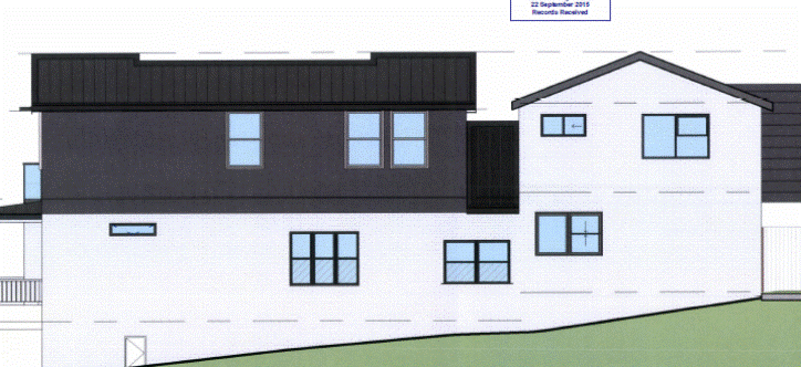
Originally proposed southern elevation
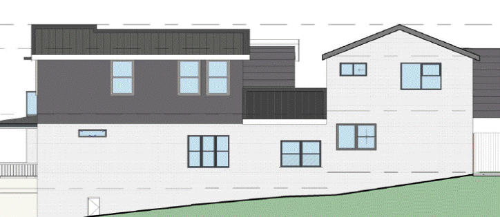
Amended southern elevation
Additional shadow diagrams:
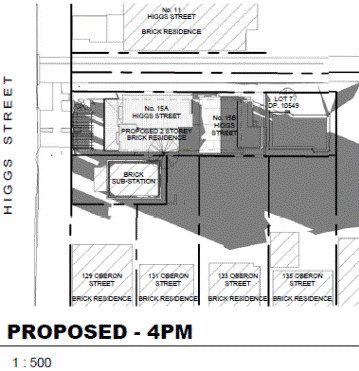
The applicant provided additional hourly shadow diagrams (between 9am and 4pm), received by Council on 30 October 2015. These shadow diagrams seek to demonstrate the proposed development will comply with the requirements under Part C1 of the RDCP requiring a minimum of three hours of solar access to neighbouring properties rear yard and north facing windows. An assessment is carried out further below under the key issues section of this report.
Site
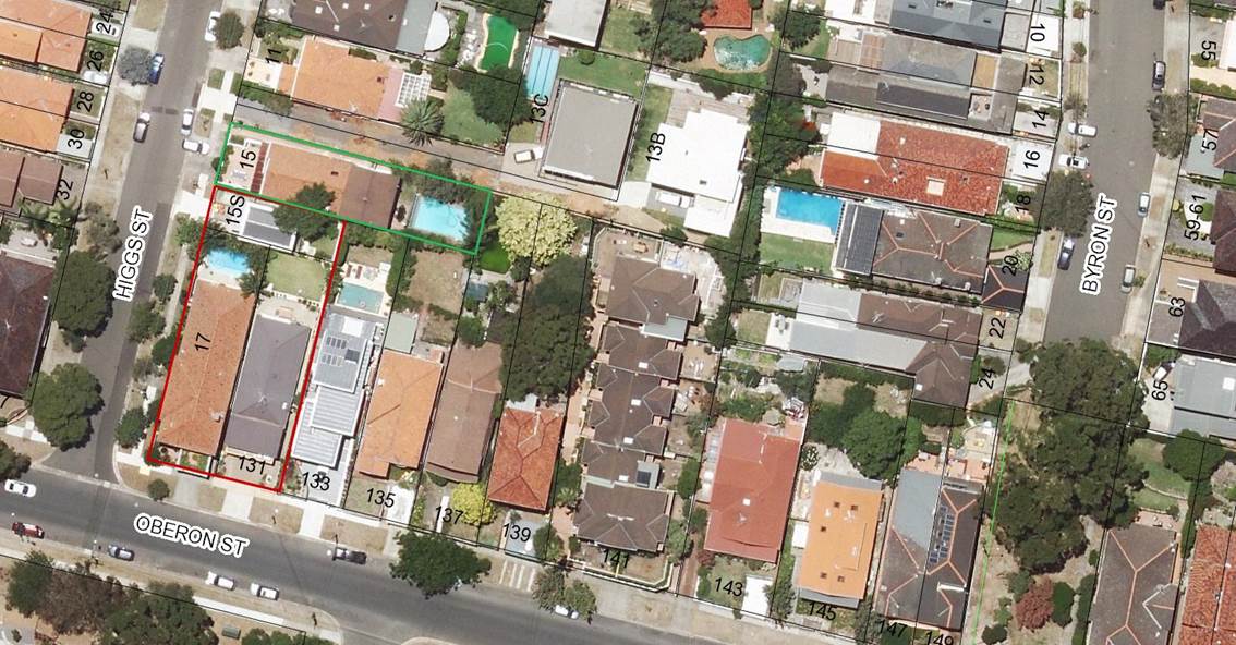
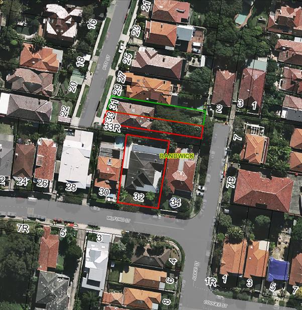
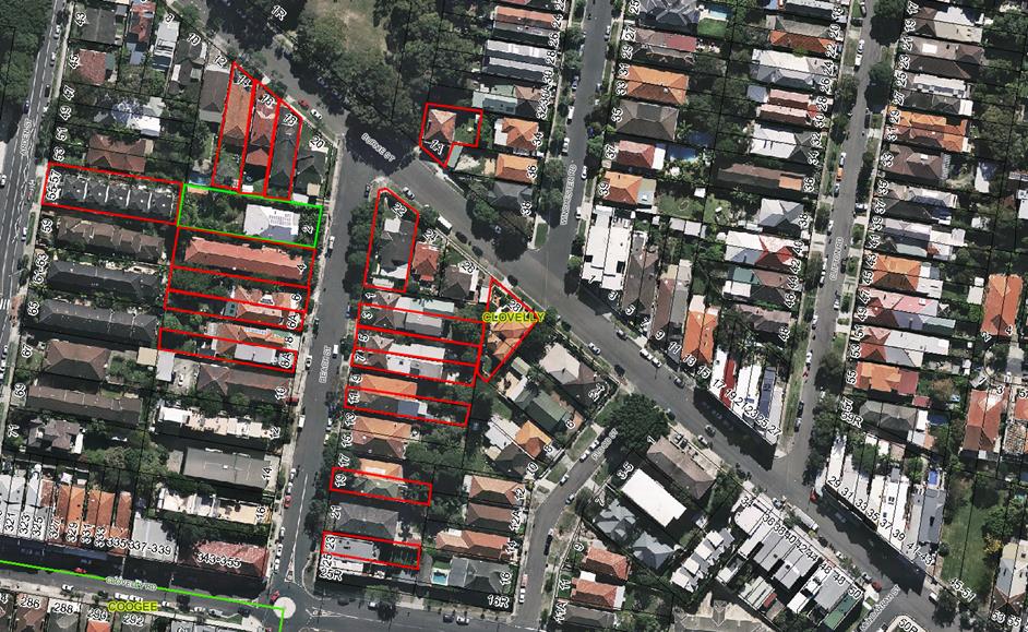
The subject site is occupied by two semi-detached dwellings with 15A Higgs Street located at the front and 15B Higgs Street located at the rear. The sites in total have a frontage width of 10.06m, side boundary depths of 41.94m and an overall site area of 417.3m².
The subject site is located on the eastern side of Higgs Street orientated on an east-west axis with the western boundary fronting Higgs Street and an eastern rear boundary adjoining a portion of the western side boundary of No. 137 Oberon Street Coogee. See photo and aerial image below.
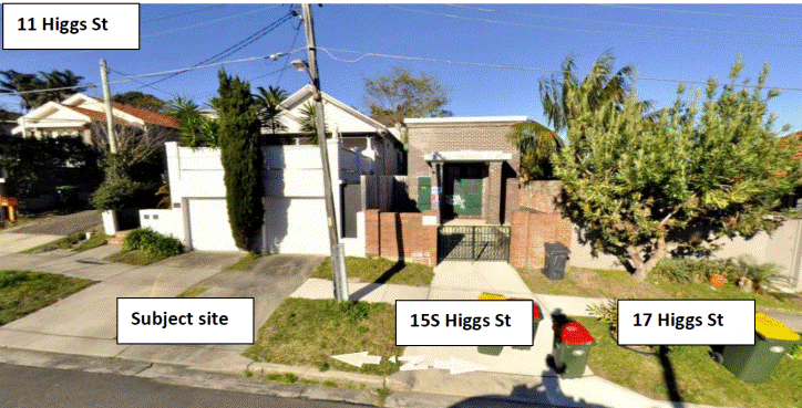
Street view photo of the subject site and neighbouring properties
As shown in the aerial image below, the southern side boundary of the site adjoins several properties. The front half of the southern side boundary adjoins an electrical substation identified as 15S Higgs Street. The rear half of the side boundary adjoins the rear of properties fronting Oberon Street from No. 133 Oberon Street to 135 Oberon Street. No. 17 Higgs Street and No 131 Oberon Street do not adjoin the subject site but rather adjoin the southern side boundary of the electrical substation.
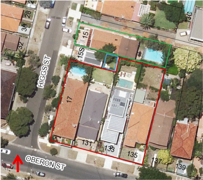
Aerial of subject site and neighbouring properties.
No 131 Oberon Street:
Identified bounded in blue in the aerial image above is a elevated grassed area whilst shown in the cadastral as being part of No. 15S Higgs Street (substation site) is accessible and used by No. 131 Oberon Street occupants – see photo below. It is unknown what if any arrangements exist between the two owners. Notwithstanding, this matter has been raised for the purposes of assessment of the level of solar access retained (and therefore shadowing caused) to the rear yard area of No. 131 Oberon Street.
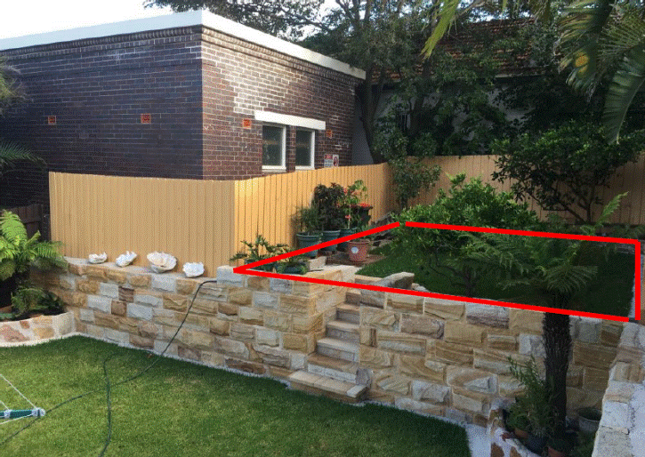
Photo of elevated rear grassed area identified as part of the property at No. 15S Higgs Street housing the substation shown behind beige fence.
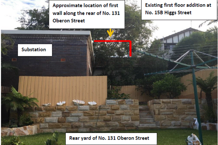
View of the subject site from the rear of No. 131 Oberon Street
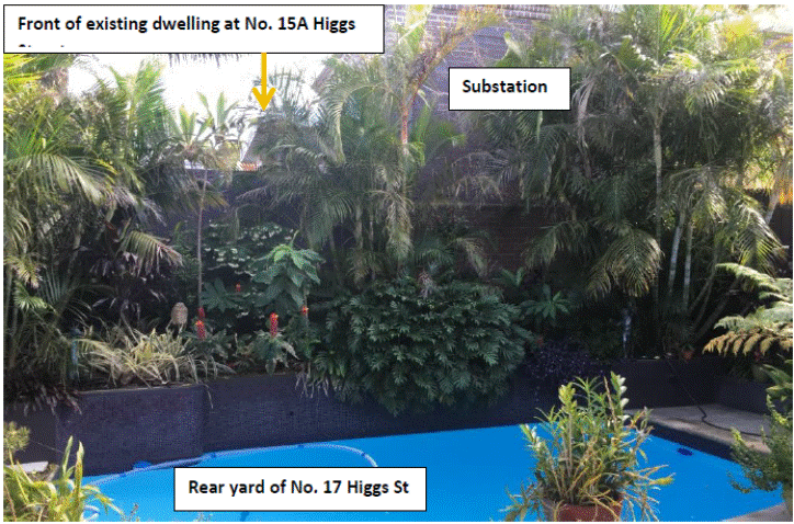
View of the subject site from the rear of No. 17 Higgs Street. Note the proposed first floor addition to No. 15A Higgs Street is located behind the front porch and is located behind the front building line of the substations.
Other properties neighbouring the subject site to the north and separated by a (6m wide) vehicle access corridor is a single dwelling identified as No. 11 Higgs Street. It is noted that the access corridor leads to two rear allotments identified as No. 13B and 13C Higgs Street both of which contain two storey scale dwellings land sloping down from north to south.
The character of the surrounding area contains predominately low density residential development consists predominantly of dwellings.
Submissions
The owners of adjoining and likely affected neighbouring properties were notified of the proposed development in accordance with the Randwick Comprehensive DCP 2013. The following submissions were received as a result of the notification process:
17 Higgs Street, Coogee
|
Issue |
Comment |
|
No mention is made to the unequal strata entitlement distribution creating grounds for future strata scheme disputes. |
The allocation of floor area and distribution of entitlements do not raise any significant planning matters. A condition is included requiring the strata plans to be amended accordingly. |
|
The proposed FSR is clearly over the 0.5:1 limit and the building which exists as a two unit strata scheme should comply with the standards. |
The existing strata subdivision of the two dwellings means that they are classified as semi-detached dwellings and as each lot is less than 300sqm there is no maximum FSR standard that applies except that a merit assessment is required against the objectives of the standard. Council’s Lawyers have advised that as each dwelling is contained on its lot and the two dwellings are only attached to each other they should be classified as semi-detached dwellings rather than as an attached dual occupancy which only allows two dwellings or one lot of land. See key issues section of this report. |
|
Concern with the effects of the proposal on the amenity and quality of life of surrounding neighbourhood relating to winter sun and privacy. |
See key issues section of this report. In relation to privacy and overshadowing impacts, these impacts are considered reasonable given the context of the site and the surrounding development. In terms of privacy, the rear yard of the neighbour’s property is viewable from the existing terrace over garage and therefore there is no change to the privacy situation. The proposed first floor balcony and windows are adequately separated from this neighbour’s rear yard. |
|
The proposed development will result in significant overshadowing to our rear yard and north facing windows. |
The overshadowing caused by the proposed development is considered acceptable. See key issues section of this report. |
|
Question as to whether proper procedure has been followed in regards to the change in the application. |
The application has been notified to the surrounding properties likely to be affected by the proposed development. Relevant matters raised in the submissions have been considered in the assessment of the application. The physical changes to the building and their impacts have been addressed in the report and the appropriate classification of the proposal has been the subject of legal advice. |
|
Legal interpretation can lift expectations that existing planning controls can be overturned on a point of law. Legal opinion is indifferent to planning outcomes. |
Council has applied a consistent approach to the definition of subdivision in being applied to both strata and Torrens lots as provided for under the Environmental Planning and Assessment Act (the Act). The proposed development will not result in an undesirable planning outcome having regard to the relevant matters for consideration under the Act. |
131 Oberon Street, Coogee
|
Issue |
Comment |
|
The design of the proposal does not reference the heritage item with regards to the scale and character. |
The proposed first floor addition is a contemporary design and contains a two storey scale that is not considered to dominate the features of the adjoining heritage item (substation). The existing roof form is not a significant element as it is setback from the front building line behind garaging at the front that already dominates the front of the site. The removal of gabled roof form and replacement with contemporary additions is balanced by the retention of the most visible portion of the garage and balustrade at the front boundary. It is considered that the contemporary lines of the first floor addition will fit in well with the simple design of the heritage item. The pergola is deleted as a condition of consent. |
|
The proposed FSR is not a minor variation and will result in unreasonable adverse impacts on our rear yard. |
As explained in the key issues section of this report the development is classified as semi-detached dwellings and as these dwellings are on lots measuring less than 300sqm each there is no maximum FSR standard that applies. As such a merit assessment is carried out against the objectives. See key issues section of this report. In brief, the proposed development will satisfy the relevant objectives of the FSR standard and will not result in any unreasonable adverse impacts on the neighbour’s property having regard to solar access, visual bulk and privacy. |
|
Loss privacy |
The windows on the southern elevation are appropriately treated or conditioned to be treated to mitigate overlooking. |
|
Overshadowing impacts |
The solar access retained to their rear yard is adequate and complies with the controls in part C1 in RDCP 2013. See key issues section of this report. |
|
The number of living areas is not a reasonable development expectation. |
The ground level contains several living area however there is predominately only one large open plan living area at ground level. There is another area which provides an alternative. The overall bulk and scale of the development is not inconsistent with the bulk and scale that would be permitted on site for the purposes of a detached dwelling house. |
|
Would like to be kept up to date with the progress of the application and if there are changes would like to be notified ahead of a decision being made. |
The application has been amended reducing the scale and therefore re-notification of the development is not necessary. Notwithstanding, the application is considered at a Council meeting to which the objectors will be notified and have the opportunity to address Council. |
15S Higgs Street, Coogee (Ausgrid)
|
Issue |
Comment |
|
The developer should make a formal submission to Ausgrid to assess impacts on infrastructure and determine local electrical supply requirements. |
An appropriate condition is included. |
|
The proposed works should not contravene Ausgrid’s technical standards and statutory requirements in regards ot safe and reliable operation and maintenance of Ausgrid’s network. |
A suitable condition is included. |
Key Issues
Classification of the development and application of the provisions of the FSR standards under the RLEP
The buildings on site are classified as a two semi-detached dwellings by virtue of being contained within their own lots and the building having a clear structural wall along the subdivision line between the two dwellings on site. As they currently stand they are appropriately defined as a pair of semi-detached dwellings.
The application was submitted and notified to neighbouring properties as seeking development consent for alterations to an attached dual occupancy which applied the maximum FSR standard of 0.5:1. However due to the development on site being classified as a semi-detached dwellings, for the purposes of the floor space ratio provisions in Clause 4.4(2B) of the RLEP, as the allotments are less than 300sqm each there is no maximum FSR standard that applies. In such instances, a merit assessment is required against the objectives for the FSR standard which is carried out below.
Floor space ratio
The RLEP 2012 and RDCP 2013 identify floor space ratio (FSR) as a measure that assists in controlling the mass and bulk of a development. The FSR operates in conjunction with building height, wall height and setback controls to define the 3D space within which a development may occur. The RLEP 2012 does not provide maximum numerical provisions for sites that are less than 300sqm and requires a merit assessment against the floor space ratio objectives.
The floor space ratio of the development as defined under the RLEP is 0.78:1 for the front lot (15A Higgs St) and 0.45:1 for the rear lot (15B Higgs St).
A merit assessment of the proposed development is carried out against the FSR objectives which seek to:
a. Ensure that the size and scale of development is compatible with the desired future character of the locality,
b. Ensure that buildings are well articulated and respond to environmental and energy needs,
c. Ensure that development does not adversely impact on the amenity of adjoining and neighbouring land in terms of visual bulk, loss of privacy, overshadowing and views.
a. Ensure that the size and scale of development is compatible with the desired future character of the locality,
The proposed development is an asymmetrically integrated design across the two allotments. Only one semi-detached dwelling (No 15A) presents to the street with the other located behind. It is noted that if the combined FSR was applied to the two sites there would be an FSR of 0.615:1 which would be below the 0.75:1 FSR standard that would apply to a combined site area 417.3sqm.
The site coverage or building footprint of each dwelling is not markedly changing as a result of the proposal and remains generally consistent with the footprint of the dwellings within the area and those along Higgs Street.
There are larger scale developments in the wider area and the proposed upper level additions will be generally consistent with the majority of these.
The proposed bulk and scale of the development is acceptable providing a two storey scale which is the envisaged scale of development on lots within the R2 low density zone. Whilst the elevated nature of the site above those neighbouring to the south will mean a larger mass it is considered that the applicant has incorporated certain building design elements that restrict the size and scale to an acceptable level having particular regard to the elements of visual bulk and solar access. These include increasing the separation between the two first floor level additions and reducing the wall heights along the southern elevation to the minimum.
Having particular regard to FSR objective a), the proposal, responds well to the surrounding built environment and the broader context of the low-density residential zone (R2) and as a whole, the proposed development will be compatible with the desired future character of the locality.
b. Ensure that buildings are well articulated and respond to environmental and energy needs,
The proposed building is well articulated, it contains good elements of visual interest at street level by responding to the elevated nature of the site. It respects the adjoining heritage item by stepping back the upper level addition 4m from the front ground level awning.
However the proposed pergola is located close to the front boundary and will unnecessarily result in additional bulk which is inconsistent with the scale and size of dwellings within these elevated parts of the site. Subject to a condition requiring the pergola to be deleted, it is considered that the overall building design elements associated with the proposal are a good planning response to the existing topography of the site and the surrounding area that will also meet environmental and energy needs of the occupants.
c. Ensure that development does not adversely impact on the amenity of adjoining and neighbouring land in terms of visual bulk, loss of privacy, overshadowing and views.
The amenity of surrounding neighbours properties are not adversely affected by the amended scheme. In terms of visual impact, solar access and privacy protection, where necessary amendments have been incorporated in to the plans received by Council on 30 October 2015. The amendment includes an increase in the separation at the upper level addition between the two semi’s. Whilst this is a minor increase in the separation it improves and achieves compliance with the solar access controls in the RDCP which requires a minimum of three hours of solar access to the neighbouring properties rear yard areas during the shortest day of the year (winter solstice).
The visual bulk of the proposed development is also considered acceptable. The proposed upper level is setback 975mm from the existing southern side boundary satisfying the minimum setback controls under the RDCP. The wall height facing the southern side boundary as viewable from the rear yard of No. 131 Oberon Street is between 5.9m and 6.25m and well below the 7m permissible under the RDCP 2013 controls for maximum wall heights.
Although the upper level when viewed from the southern neighbour’s properties will have greater mass than the current building, this is largely a consequence of the high land level of the subject site which is a natural topographical characteristic that is exhibited along the majority of the subject sites southern side boundary as well as other properties further north along Higgs Street. It is also noted that the rear boundary of the neighbour’s property at No. 131 Oberon Street is not technically adjacent to the southern side boundary of the subject site but is rather setback 7.6m away.
Notwithstanding, it is considered that the objective c is being satisfied where the massing of the development is minimised by incorporating the following design elements:
· Additional separation between the upper level additions reduces the length of walls viewable from the rear of neighbouring properties to the south and also achieves greater levels of solar access to their rear yards;
· Windows along the southern elevation break up the expanse of walls
· Lower than permissible external wall heights along the southern elevation minuses the visual bulk of the development
· Side setbacks provided at the upper level are greater than the minimum required under the RDCP 2013 for low density development.
Overall, the proposed development, as amended, will be appropriately scaled and located within the site containing an appropriate envelope that will not result in any unreasonable adverse impacts on neighbouring properties or streetscape character and therefore satisfy the floor space ratio objectives.
Solar access to neighbouring development:
Several submissions have been received by Council concerning the level of overshadowing to the southern neighbours rear yards as a result of the proposed development.
The relevant controls under Councils RDCP relating to the required minimum levels of solar access to the neighbours rear yard areas and northern facing windows is that they receive a minimum of three hours of solar access.
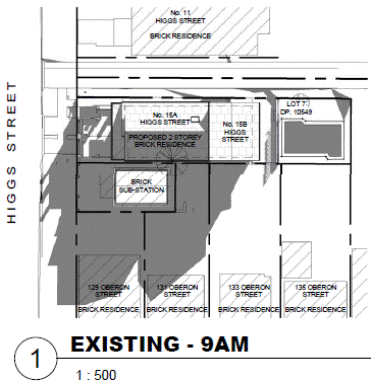
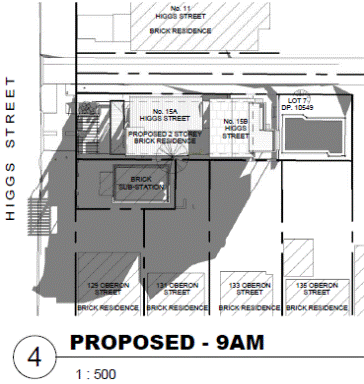
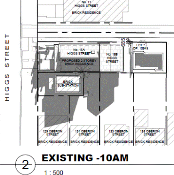
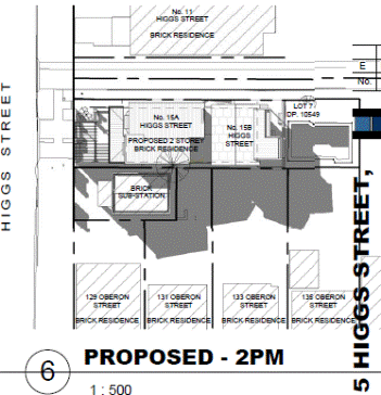
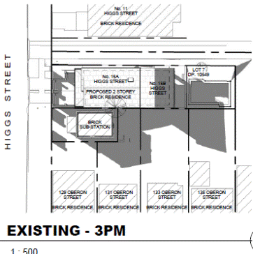
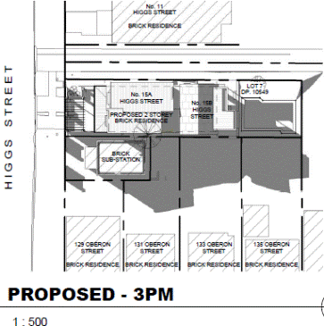
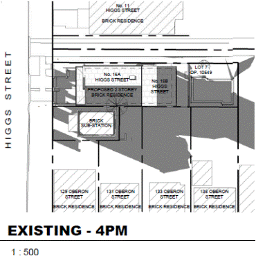
The following shadow diagrams were submitted as part of amended material received by Council on 30 October 2015. The shadow diagrams show the existing shadow and the shadow from the proposed development including that from the existing substation at No. 15S Higgs Street. The neighbouring properties to the south from left to right are identified as No. 17 Higgs Street, No, 131, 133 and 135 Oberon Street.
|
9am shadow - existing |
9am shadow - proposed |
|
|
|
|
10am shadow - existing |
10am shadow - proposed |
|
|
|
|
11am shadow - existing |
11am shadow - proposed |
|
|
|
|
12noon shadow - existing |
12noon shadow - proposed |
|
|
|
|
1pm shadow - existing |
1pm shadow - proposed |
|
|
|
|
2pm shadow - existing |
2pm shadow - proposed |
|
|
|
|
3pm shadow - existing |
3pm shadow - proposed |
|
|
|
|
4pm shadow - existing |
4pm shadow - proposed |
|
|
|
An assessment of overshadowing and solar access to neighbouring properties is carried out as follows:
· Solar access and overshadowing to neighbours rear yards
No 17 Higgs Street:
There is also no additional shadow impact to this neighbour’s rear yard. The majority of the shadows are cast by the existing substation at No. 15S Higgs Street and by the existing high boundary fencing within their own site.
No 131 Oberon Street
The proposed development causes additional shadows to their rear yard between the hours of 9am, and 12noon. Solar access to their rear yard is retained between 10am and 3pm with the majority of their rear yard having direct solar access between 12noon and 3pm. The solar access requirements are satisfied.
Taking into consideration the rear elevated grassed area, which is part of the substation site, whilst the proposed development adds shadows to this area there is already substantial overshadowing to this area. The additional overshadowing is not considered fatal to the support of the proposed development as this area is particularly vulnerable to overshadowing being in close proximity to the southern side boundary of the subject site and below their ground level.
No. 133 Oberon Street
The proposed development results in additional overshadowing to their rear yard throughout the day between 9am and 4pm. However the additional overshadowing is mostly over the rear sections of their rear yard with solar access retained to the principle area of their rear yard area and pool area. The proposed development complies.
No. 135 Oberon Street
Solar access of this neighbour’s rear yard is not affected between the hours of 9am and just before 12 noon by the proposed development. The proposed development results in additional overshadowing to their rear yard between 12 noon and 4pm. The salient point about the additional overshadowing is that parts of their rear yard are still retaining solar access during this period.
Overall, despite the proposed development resulting in additional shadow impacts to the rear yards of these southern neighbours it is considered that the additional shadow impacts are also acceptable for the following reasons:
o The subject site being elevated above the rear yards of these neighbours to the south is a natural characteristic of the topography of the subject site and those along the same axis.
o The east-west configuration of the site means that the adjoining land to the south will be unavoidably impacted by greater levels of shadows
o The proposed development meets the relevant provisions for FSR, height, wall height, and site coverage under the RLEP and the RDCP.
o The proposed development provides greater than the 900mm minimum RDCP 2013 side setback control from the southern side boundary providing a 975mm side setback for the first floor addition to No. 15A Higgs Street (the front allotment) and a 1245mm side setback from the southern side boundary for the first floor addition to No. 15B Higgs Street.
· Solar access and overshadowing to neighbours north facing windows
The proposed development results in additional showing to the north facing windows of No. 17 Higgs Street and No. 131 Oberon Street. The development is assessed against the RDCP controls requiring a minimum of three hours solar access.
131 Oberon Street
No 131 Oberon Street is not unduly impacted by the proposed development and will receive the minimum of three hours during the winter solstice. It is noted that development consent has been granted for extensions to the height of the boundary fencing at the rear and side boundaries which means that these existing structures would overshadow the rear yard of this neighbour’s property around the 8am and 4pm times during the winter solstice.
No. 17 Higgs Street
The proposed development results in additional shadows to the north facing windows during the winter solstice between 8am and before 10am. Despite the additional shadows during the morning period, their north facing windows will continue to receive the minimum three hours between 11am and 4pm (excluding those shadows that may be cast by the existing secondary street boundary fencing.
Visual Privacy
· Windows
The proposed development contains several bedroom and bathroom windows along the southern elevation of the first floor level will have the potential to result in additional overlooking into the rear yards of neighbouring properties to the south (those facing Oberon Street). The applicant has sought to reduce the privacy impact by treating the bottom sashes of the bedroom windows with obscure glazing and restricting the opening of the bottom sash to a maximum of 125mm. Given the windows are attached to relatively low use rooms, which are not living rooms, and the restricted view through a 12.5cm gap it is not considered that there will be any significant privacy impacts on the neighbouring properties.
Required treatment to windows
The ground level south facing kitchen window is identified as having obscured glazing to the bottom sash; however it is fully operable and given the high use nature of this room, it is considered reasonable to include a condition restricting the bottom sash of this window to a maximum of 125mm. This condition is considered to ensure reasonable privacy protection of the neighbour’s properties to the rear.
No other windows are considered to require further treatment as they are either low use rooms such as bathrooms, laundries or existing windows servicing the same rooms.
· Balcony
There is one upper level balcony at the front however its shallow 1m depth and attachment to a low use bedroom does not raise any significant privacy concerns.
Outbuilding and front setback
The proposed development seeks to locate a pergola at the front of the site facing Higgs Street which is inconsistent with the RDCP control requiring outbuildings amongst other elements such as POS to be located behind the front building line. Although the POS is already at the front an unavoidable existing site condition however it is not considered that this outcome extends to locating a permanent structure that will be readily viewable at the front will be inconsistent with the predominant and desired built form and front setbacks from Higgs Street.
Therefore, the proposed pergola is not supportable and a condition is included requiring it to be removed from the application. This condition is considered to maintain reasonable protection of the character along Higgs Street.
Relationship to City Plan
The relationship with the City Plan is as follows:
Outcome 4: Excellence in urban design and development.
Direction 4a: Improved design and sustainability across all development.
Financial impact statement
There is no direct financial impact for this matter.
Conclusion
The proposed development has been assessed against FSR RLEP 2012 standard and the relevant Randwick DCP 2013 controls and objectives and is considered to be acceptable.
Approval of the development is considered acceptable as it will be in line with the objectives of the abovementioned documents and will not result in any significant environmental impact on neighbouring properties in terms of overshadowing, site planning and streetscape amenity (as conditioned).
It is therefore considered that the proposed development is reasonable, subject to the recommended non-standard conditions below and the standard conditions contained within the Compliance report (attached).
|
That Council, as the consent authority, grants development consent under Sections 80 and 80A of the Environmental Planning and Assessment Act 1979, as amended, to Development Application No. DA/658/2015 for Alterations and additions to existing semi-detached dwellings including ground and first floor additions and new pergola to 15A Higgs Street, first floor alterations and additions to 15B Higgs Street, at No. 15A and 15B Higgs Street, Coogee NSW 2034, subject to the following non standard conditions and the standard conditions contained in the development application compliance report attached to this report:
Non-standard conditions
Amendment of Plans & Documentation 2. The approved plans and documents must be amended in accordance with the following requirements:
a. The bottom sashes of the south facing kitchen window must be provided with translucent, obscured, frosted or sandblasted glazing and operability be restricted to a maximum of 125mm above the bottom sill.
b. The location of air conditioning units must satisfy the relevant criteria under the State Environmental Planning Policy - Exempt and Complying Development Codes 2008.
c. The pergola located over the terrace at the front shall be deleted from the application.
|
|
DA Compliance Report - 15A & 15B Higgs Street, Coogee |
Included under separate cover |

Development Application Report No. D28/16
Subject: 1-1A Chapman Avenue, Maroubra (DA/925/2015)
Folder No: DA/925/2015
Author: Plandev Pty Ltd, Thomas Mithen
Proposal: Alterations and additions to the existing dwelling house.
Ward: Central Ward
Applicant: Mrs R E Madin & Mr M W Madin
Owner: Mr G W Hasler & Ms E E Hasler & Mrs R E Madin & Mr M W Madin
Summary
Recommendation: Approval
|
|
|
|
Subject Site |
|
|
|
|
|
|
|
|
|
|
|
|
|
|
Submissions received
|
|
|
Ù North
|
|
|
Locality Plan |
Development Application Executive summary report
The application was assessed by the external planning consultant and referred to the Planning Committee for determination as a nearby property is owned by a Randwick City Councillor.
1. Proposal
The proposal is for alterations and additions to the existing two storey attached dual occupancy, comprising a separate dwelling at each level. The proposed alterations and additions include:
ground floor dwelling
· refurbishment of the existing bathroom;
· construction of a new ensuite;
· internal re-planning to create an open plan kitchen and living area;
· construction of an outdoor deck adjoining the living area;
· construction of new external stairs to the first floor at the south-eastern elevation; and
· installation of an external laundry;
first floor dwelling
· refurbishment of the existing bathroom;
· internal re-planning to create an open plan kitchen and living area; and
· conversion of the existing sunroom into a balcony.
The proposal is illustrated in Figures 2 and 3.

![]()
![]()

![]()


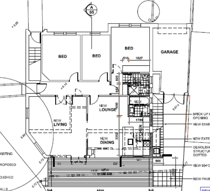
Figure 2 – Proposed changes to the ground floor dwelling

![]()
![]()
![]()


![]()


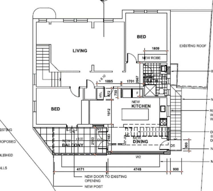
Figure 3 – Proposed changes to the first floor dwelling
2. Site
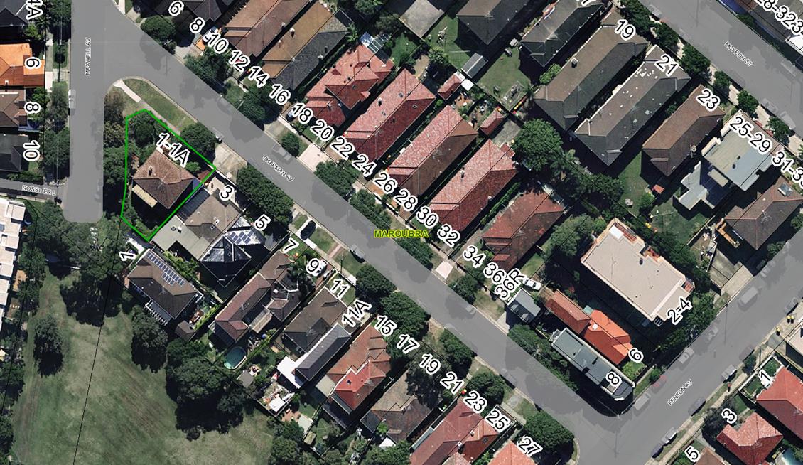
The subject site is irregular in shape and has an area of 412 sqm. It is a corner site and has dual street frontage to Chapman Avenue at the north-eastern boundary and Maxwell Avenue at the western boundary.
The site contains a two storey attached dual occupancy, comprising one dwelling at each level (refer to Figure 4). The entry to the ground floor dwelling is at the Maxwell Street frontage. A separate entry to the first floor dwelling is at Chapman Avenue. The south-eastern setback contains a single garage fronting Chapman Avenue.
On 16 May 1989, Council approved a development application (DA) for the addition of a new bedroom to the first floor of the existing duplex (D73/89). Council’s planning assessment report indicates that the duplex had been in existence prior to 1951.
The surrounding area is predominately residential in character and Chapman Avenue contains a mix of one and two storey freestanding and semi-detached dwelling houses. The property adjoining to the north-east at No. 3 Chapman Avenue contains a single storey semi-detached dwelling house. The property adjoining to the south contains a two storey dwelling house at No.1 Maxwell Street.
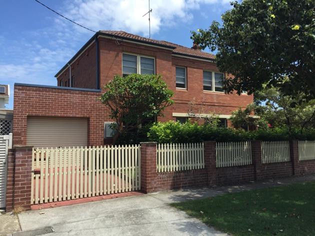
Figure 4 – View from Chapman Avenue
3. Submissions
The owners of adjoining and likely affected neighbouring properties were notified of the proposed development in accordance with the Randwick Comprehensive DCP 2013 (RDCP 2013). No submissions were received.
4. Key Issues
Solar Access
The proposed addition to the southern corner of the building extends the internal living areas of both dwellings, resulting in a minor change to the built form. The existing height of the building does not change as a result of the proposal. The solar access controls in RDCP 2013 require a minimum of three hours direct sunlight to adjoining properties between 8:00am and 4:00pm at the winter solstice. The applicant submitted shadow diagrams with the application, representing the worst case scenario at the winter solstice. The applicant’s solar analysis shows there would be a minor increase in shadow at 9:00 am on Maxwell Avenue. At midday there would be some minor additional shadow in the south-western corner of No. 3 Maxwell Avenue, which is the adjoining residential property to the south. However, the minor additional shadow cast by the proposal affects the roof of an existing outbuilding, resulting in no loss of sunlight to the rear yard at No. 3 Chapman Avenue. Likewise, the minor additional shadow cast by the proposal at 3:00 pm would also affect the roof of the existing dwelling at No. 3 Chapman Avenue and not its rear yard. The additional shadow cast by the proposal would not result in any unreasonable shadow impacts to the adjoining property at No. 3 Chapman Avenue. The proposal is considered to satisfy the relevant objectives and controls in RDCP 2013.
Privacy
The new staircase and landing on the south-eastern elevation would result in potential privacy impacts to the adjoining property at No. 3 Chapman Avenue. However, the downward view from the top of the new staircase would take in the roof of the dwelling at No. 3 Chapman Avenue and the existing out-building would cut off any direct views to its rear yard. Furthermore, the staircase is setback between two to three metres from the common boundary with No. 3 Chapman Avenue, which exceeds the side setback control of 1.2 m in RDCP 2013.
The potential views from the new balcony at the first floor include the front yard of the existing dwelling at No. 1 Maxwell Avenue to the south, and to a lesser extent the first floor windows along the side elevation facing the subject site. The existing vegetation on the boundary would assist in screening the property at No. 1 Maxwell Avenue.
The proposal would not result in any unreasonable privacy impacts to the adjoining properties.
Car Parking
DCP 2013 requires on-site parking at the following rate:
· one car space per dwelling house up to 2 bedrooms; and
· two space per dwelling house up to 3 bedrooms.
A total of three car spaces are to be provided on the site based on the parking rate in RDCP 2013 for dual occupancies. The proposal includes one car space within the existing garage, representing a shortfall of two car spaces. The proposal involves a minor increase in floorspace equating to 10 sqm to accommodate the expanded kitchen and living area for each dwelling. However, the number of bedrooms for both dwellings does not change compared to the existing situation, and there would be no additional parking demand generated by the proposal in accordance with Council’s parking rates. RDCP 2013 provides exceptions to the parking rates in certain circumstances particularly where there is good access to public transport. The subject site is located within walking distance to the public bus stop at Maroubra Beach, which is serviced by express buses at peak hour to Maroubra Junction and the Sydney CBD. Given the dual occupancy is existing and the proposal would not generate any additional demand for parking on the site, the provision of two additional car spaces to satisfy Council’s current parking rates is not warranted in this circumstance.
Private Open Space
RDCP 2013 requires each dwelling in a dual occupancy to have a contiguous private open space (POS) at ground level with a minimum dimension of 5 m x 5 m. However, RDCP 2013 acknowledges that this cannot be achieved in an attached dual occupancy where the dwellings are horizontally stacked (i.e. one dwelling situated above another). The POS serving the ground floor dwelling is 7 m x 7 m in dimension (including the proposed outdoor deck), which satisfies the minimum POS requirements in RDCP 2013. The dwelling at the first floor currently has no POS serving the occupants. However, the proposal involves the conversion of an existing sunroom into an outdoor balcony, which would form an extension to the internal living area. The proposed new balcony is 11 sqm in area and has good access to direct sunlight from the northwest. The proposal would therefore result in a significant improvement in amenity for the first floor dwelling compared to the existing situation.
Relationship to City Plan
The relationship with the City Plan is as follows:
Outcome 4: Excellence in urban design and development.
Direction 4a: Improved design and sustainability across all development.
Financial impact statement
There is no direct financial impact for this matter.
Conclusion
The proposed alterations and additions to the existing attached dual occupancy would not result in any unreasonable impacts on the adjoining properties or the streetscape. The proposal is generally consistent with the relevant provisions in RDCP 2013. No submissions were received following the exhibition period. The proposal would enhance internal amenity for both dwellings by providing open plan living and kitchen areas, improved POS and good access to sunlight.
The application is recommended for approval, subject to conditions outlined in the attached Compliance Report.
|
That Council, as the consent authority, grants development consent under Sections 80 and 80A of the Environmental Planning and Assessment Act 1979, as amended, to Development Application No. 925/2015 for alterations and additions to the existing attached dual occupancy, at No. 1-1a Chpman Avenue, Maroubra, subject to the following standard conditions contained in the development application compliance report. |
|
DA Compliance Report - 1-1A Chapman Avenue, Maroubra |
Included under separate cover |

Development Application Report No. D29/16
Subject: 697-699 Anzac Parade, Maroubra (DA/107/2013/A)
Folder No: DA/107/2013/A
Author: Matthew Choi, Senior Environmental Planning Officer
Proposal: Section 96(2) modification of the approved development by increasing the western setback to 3 metres on levels 1 & 2, reduction in the overall height of the building by 600mm, reduction in the floor space ratio and deletion of apartment no. 605 and various amendments to address the requirements of the conditions of consent.
Ward: Central Ward
Applicant: Fox Johnston Architects
Owner: Mr. A S C Chan
Summary
Recommendation: Approval
|
|
|
|
Subject Site |
|
|
|
|
|
|
|
|
|
|
|
|
|
|
Submissions received
|
|
|
Ù North
|
|
|
Locality Plan |
Development Application Executive summary report
This section 96 modification application is referred to the Planning Committee as the original development application was determined by Council at the Planning Committee meeting on the 3 December 2013.
Proposal
The subject section 96 modifications involve the following works:
Ground floor level:
· New splay to the north-western corner to shop no.4 and adjacent the proposed vehicular access way to the basement parking level as required per condition no. 22
· The external wall to the vehicular access ramp has been relocated up adjacent to the southern and western boundary to allow Council access to the stormwater as required per condition no. 34
· Inclusion of new service water main termination cupboard at the north-western corner of the site.
First floor level:
· Modification of sliding door and window openings to the western external wall of apartment no. 106 to a single window with screen
· Installation of privacy screen along the western and southern edge of the private open space of apartment no. 106
· Deletion of external wall between the deck and the courtyard to apartment no. 6
· Setback the western external wall 3 metres from the western boundary from apartment no. 106 as required per condition no. 2a
· Deletion of brick screen wall adjacent the communal courtyard and set up to the eastern property boundary as required per condition no. 2c
· Lower the finished floor level by 600mm as required per condition no. 2e
Second floor level:
· Modification of sliding door and window openings to the western external wall of apartment no. 206 to a single window with screen
· Setback the western external wall 3 metres from the western boundary from apartment no. 206 as required per condition no. 2a
· Deletion of brick screen wall adjacent the communal courtyard and set up to the eastern property boundary as required per condition no. 2c
· Lower the finished floor level by 600mm as required per condition no. 2e
Third floor level:
· Lower the finished floor level by 600mm as required per condition no. 2e
Fourth floor level:
· Lower the finished floor level by 600mm as required per condition no. 2e
Fifth floor level:
· Lower the finished floor level by 600mm as required per condition no. 2e
Sixth floor level:
· Amend condition 2(d) to delete apartment no. 605 and reposition fire stairs and new plant room set up to the northenr boundary adjacent apartment no. 606
· Lower the finished floor level by 600mm as required per condition no. 2e
Roof floor level:
· Lower the finished floor level of the roof and associated plant and equipment as required per condition no. 2e
Site
The site is presently occupied by one and two storey buildings and is situated within the Maroubra Junction Business Centre. The surrounding development is comprised of multi storey buildings varying in height between 6 -10 storeys.
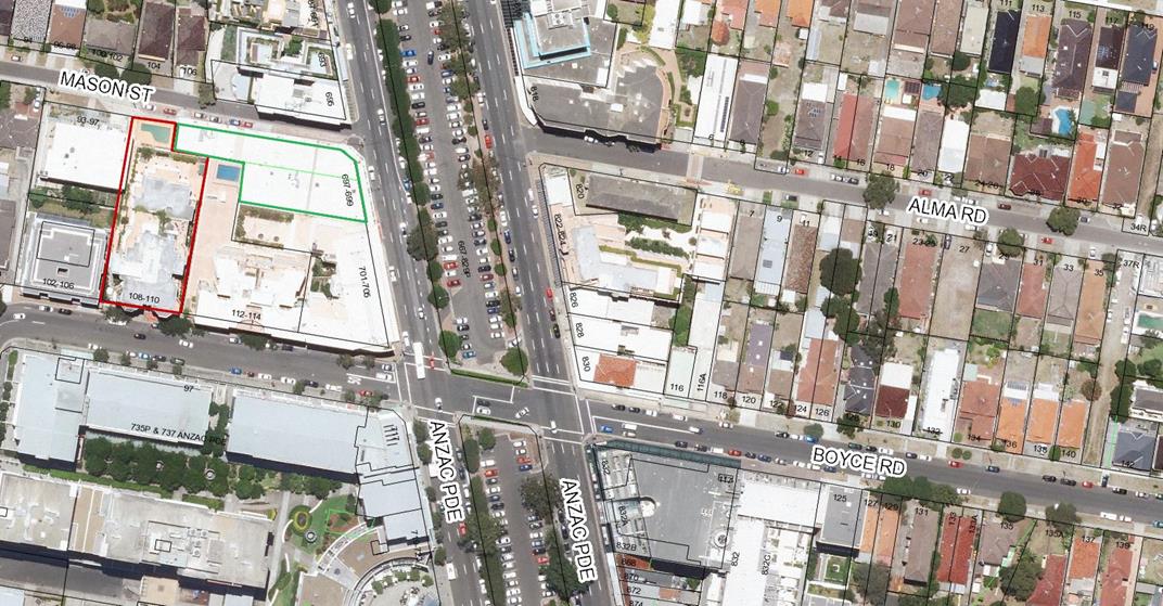
The site is has a slight fall in topography from Anzac Parade to the rear. It has a frontage of 25.5m to Anzac parade and a maximum depth of 56.9m being the frontage to Mason Street. The two allotments that make up the development site have a combined site area of 1104m². The subject site and surrounding development is shown in the figures below.
Figure 1. Subject site with 701 Anzac, 112 Boyce Rd, and 108 Boyce Rd in the background
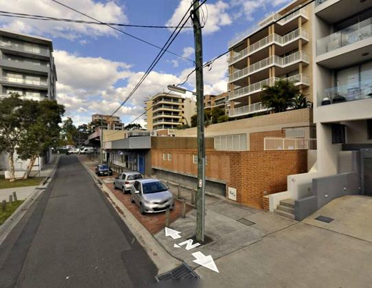
Figure 2. View of subject site from Mason St, with pool of 108 Boyce Rd (red facebrick) in foreground
Section 96 Amendment
Substantially the same development:
The proposal involves minor modifications to the approved development including changes to doors and window openings, new privacy screen along the eastern-most boundary and amendments to the approved plans to address the conditions that were imposed as part of the previous consent including condition nos. 2(a) to 2(e). The proposed modifications will not result in a change to the nature of the original application and the works will result in an application that is substantially the same as that for which was consent was originally granted. The amendments will not result in any unreasonable impact upon either the amenity of the adjoining premises or the streetscape.
Notification and consideration of submissions:
The owners of adjoining and likely affected neighbouring properties were notified of the proposed development in accordance with the Randwick Comprehensive DCP 2013. The following submissions were received as a result of the notification process:
· 108-110 Boyce Road, Maroubra
|
Issues |
Comments |
|
Loss of solar access |
The section 96 modification involves a reduction to the building envelope including lowering of the overall building height by 600mm and the deletion of unit no. 605 as conditioned by the previous development consent. The development will not contribute to any significant overshadowing impacts to the affected neighbour given that development consent has already been granted as part of the original application. |
|
Visual and acoustic privacy |
The section 96 modification will not contribute to any visual and acoustic privacy impacts to the neighbouring premises. The amendments involve demonstrating compliance with the conditions of consent that were included as part of the original determination. Notwithstanding the above, the proposed modifications include a new privacy screen on the southern-edge of apartments 106 and 206 which will minimise cross viewing into the adjoining courtyard spaces to the objectors premises. |
|
Building Height |
There is no recourse to lower the overall height of the building further given the works have received development consent. The section 96 modification seeks to demonstrate compliance with condition 2(e) and involves a reduction in the overall height of the building by an additional 600mm. |
|
Structural Integrity |
Suitable conditions of consent have been included to ensure the structural integrity of the adjoining neighbours
|
|
Dilapidation Report |
A standard condition of consent has been included as part of the original application that a dilapidation report be carried out prior to the commencement of any demolition, excavation or building works. The report will be issued to the affected owners prior to commencing any works. |
Key Issues
View Loss Impacts:
The subject section 96 modification seeks to delete condition no. 2(d) of the original development consent which read as follows:
2d. Unit 605 and the associated fire stairs at the upper level shall be deleted from the plans. Details must be submitted to Council’s Manager Development Assessments for approval prior to the issuing of a construction certificate.
The proposed modification involves deleting apartment 605 at the sixth floor level as per the above condition, however also seeks to retain and reposition the fire stairs in order to comply with the relevant BCA requirements for access and safety. Condition no. 2(d) was included as part of the original consent given both the fire stairs and apartment no.605 resulted in a breach to the number of storeys to building height control and would create the most significant view loss impacts of a distant view of the Sydney CBD and city skyline including Centrepoint Tower to the southern neighbouring building at no. 112-114 Boyce Road.
The section 96 modification seeks to splay the fire stairs to ensure a view corridor is preserved and aligns with the south-western edge of the blade wall to the deck of apartment 404, 504 and 604. The fire stairs will only impact views from a northern aspect and the view obtained from this aspect is the walls, roofs and balconies of the buildings between nos. 679-695 Anzac Parade, Maroubra. Consequently, the proposed section 96 modifications are acceptable and will allow for equitable distant views of the city skyline to be maintained and the stairs will not result in any appreciable view loss impacts from the top most levels of no. 112-114 Boyce Road. The proposal will continue to comply with the Land and Environment Court Planning Principle established in the matter of Tenacity Consulting v Warringah (2004) NSWLEC 140.
Figure 1: The existing view from the balcony of no. 37/112 Boyce Road
Figure 2: The extent of view loss from the approved development from no. 37/112 Boyce Road
Relationship to City Plan
The relationship with the City Plan is as follows:
Outcome 4: Excellence in urban design and development.
Direction 4a: Improved design and sustainability across all development.
Financial impact statement
There is no direct financial impact for this matter.
Conclusion
The proposed modifications to the approved development has been assessed against the requirements of the relevant planning guidelines of the RLEP 2012, the relevant council policies including the RDCP 2013 as well as in regard to Section 79C of the Environmental Planning and Assessment Act, 1979, as amended. The proposed modification will result in substantially the same development as that previously approved and will not result in any unreasonable adverse impacts upon either the amenity of the adjoining premises or the character of the locality.
|
That Council, as the consent authority, grants development consent under Sections 80 and 80A of the Environmental Planning and Assessment Act 1979, as amended, to Development Application No. DA/107/2013 for modifications of the approved development by increasing the western setback to 3 metres on levels 1 & 2, reduction in the overall height of the building by 600mm, reduction in the floor space ratio and deletion of apartment no. 605 and various amendments to address the requirements of the conditions of consent., at No. 697-699 Anzac Parade, MAROUBRA, subject to the following conditions:
A. Amend Condition No. 1 to read as follows:
Approved Plans & Supporting Documentation 1. The development must be implemented substantially in accordance with the plans and supporting documentation listed below and endorsed with Council’s approved stamp, except where amended by Council in red and/or by other conditions of this consent:
except as amended by the Section 96A plans as detailed below, and only in so far as they relate to the modifications highlighted on the Section 96 plans and detailed in the Section 96 application, except as may be amended by the following conditions and as may be shown in red on the attached plans:
B. Delete Condition Nos. 2(a), 2(b), 2(c), 2(d) and 2(e) |
Nil
Development Application Report No. D30/16
Subject: 14 Beach Street, Clovelly (DA/49/2016)
Folder No: DA/49/2016
Author: Plandev Pty Ltd, Thomas Mithen
Proposal: Construction of carport structure to rear of existing residential flat building.
Ward: North Ward
Applicant: Mr R Glaser
Owner: Heglas Pl
Summary
Recommendation: Approval
|
|
|
|
Subject Site |
|
|
|
|
|
|
|
|
|
|
|
|
|
|
Submissions received
|
|
|
Ù North
|
|
|
Locality Plan |
Development Application Executive summary report
The application was assessed by external planning consultant and referred to Council for determination as an adjoining property owner is a Randwick City Council employee.
1. Proposal
The proposal is for the construction of a single storey carport providing all-weather protection for four vehicles in the existing parking area at the rear of the site. The carport structure would be constructed of steel posts and a colourbond roof (refer to Figures 1 and 2).
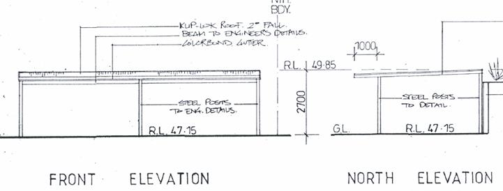
Figure 1 – Proposed carport structure
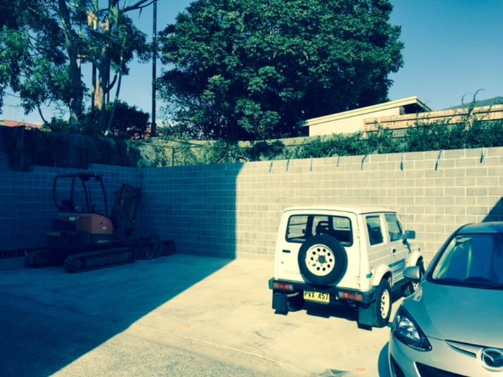
Figure 2 – Location of the proposed carport structure
State Environmental Planning Policy (SEPP) – Exempt and Complying Development Codes (2008) allows for the construction of a carport without consent, subject to satisfying specific development standards. The proposed carport structure is 2.7 m in height, which is below the 3 m height standard, and setback 2 m to the southern boundary and 3.7 m to the western rear boundary, which exceeds the minimum 900 mm setback standard. However, the setback at the northern boundary would be 700 mm, which is 200 mm less than the setback standard, and therefore it is not exempt development. Despite the technical non-compliance with the Exempt and Complying Codes SEPP, the proposal is considered minor and would have minimal impact on the surrounding area.
2. Site
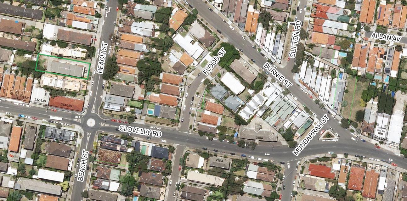
The subject site has an area of 775 sqm. It contains a three storey residential flat building (RFB), comprising 13 apartments. There is currently parking available for 12 vehicles on the site, including ground level garages and the hardstand area at the rear of the site the subject of this application. The site slopes down from the rear boundary to the street, representing a change in level of approximately 7 m. Adjoining to the north is a three storey RFB containing five dwellings at No. 12 Beach Street. Adjoining to the south is a three storey RFB containing four dwellings above basement parking at No. 16 Beach Street.
3. Submissions
The owners of adjoining and likely affected neighbouring properties were notified of the proposed development in accordance with the Randwick Comprehensive DCP 2013. No submission were received.
4. Key Issues
Overshadowing
The proposed carport structure is a maximum of 2.7 m in height, and the additional shadow cast would fall on the adjoining stairs and hardstand area within the subject site. The proposal would not result in any additional shadow on the adjoining property to the south at 16 Beach Street.
Visual Impact
The proposed carport structure would not be readily visible from the street due to the intervening residential flat building. Due to the site topography, the proposed carport structure would generally be located below the ground floor level of the adjoining properties, and therefore would not result in any adverse bulk and scale impacts when viewed from the adjoining properties (refer to Figures 3 and 4).
![]()
![]()
![]()
Figure 3 – Adjoining residential flat building at No. 12 Beach Street
![]()
![]()
![]()
Figure 4 – Adjoining residential flat building at No. 16 Beach Street
Acoustic Impacts
The proposed carport would assist in reducing vehicle noise by partly enclosing the existing parking area. The proposal would therefore result in a positive acoustic impact on the adjoining properties.
Relationship to City Plan
The relationship with the City Plan is as follows:
Outcome 4: Excellence in urban design and development.
Direction 4a: Improved design and sustainability across all development.
Financial impact statement
There is no direct financial impact for this matter.
Conclusion
The proposed carport structure would not result in any adverse amenity impacts to the adjoining properties in terms of overshadowing or visual bulk. The proposal would provide all-weather protection for vehicles on the site, and also assist in reducing vehicle noise to the adjoining properties by enclosing part of the existing parking area at the rear of the site.
The application is recommended for approval, subject to conditions outlined in the attached Compliance Report.
|
That Council, as the consent authority, grants development consent under Sections 80 and 80A of the Environmental Planning and Assessment Act 1979, as amended, to Development Application No. 49/2016 for construction of carport structure to rear of existing residential flat building, at No. 14 Beach street, Clovelly, subject to the standard conditions contained in the development application compliance report.
|
|
DA Compliance Report - 14 Beach Street, Clovelly |
Included under separate cover |
Development Application Report No. D31/16
Subject: 31 Pitt Street, Randwick (DA/373/2015/A)
Folder No: DA/373/2015/A
Author: Frank Ko, Coordinator Fast Track
Proposal: Section 96 application to delete Condition 2(a) of the consent in relation to the deletion of rear upper level balcony and reduction in the size of the upper level bedroom
Ward: East Ward
Applicant: Mr R J Foley
Owner: Mr R J Foley
Summary
Recommendation: Refusal
|
|
|
|
Subject Site |
|
|
|
|
|
|
|
|
|
|
|
|
|
|
Submissions received
|
|
|
Ù North
|
|
|
Locality Plan |
Development Application Executive summary report
The application is referred to the Planning Committee as the original development application was determined by Council on 27 October 2015.
1. Details of Current Approval
The original Development Application for alterations and additions to the existing semi-detached dwelling including new first floor addition and front hardstand car space was approved at the Ordinary Council meeting on 27 October 2015 subject to conditions including Condition 2(a) which requires the deletion of rear upper level balcony and reduction in the size of the rear upper level bedroom. Condition 2(a) of the consent read as follows:
2(a) The proposed upper level addition shall be amended in the following manner:
1) The rear upper level balcony shall be deleted.
2) The rear upper level eastern wall to the bedroom shall be shifted west by 1m. A maximum 1m depth of balcony may be provided to the rear upper level adjacent to the repositioned bedroom wall.
2. Details of Proposed Modification
The subject Section 96(2) application seeks consent to delete Condition 2(a) and make amendments to the configuration and design of the first floor balcony as follows:
· Increase the setback of the rear upper level balcony by 900mm from the southern side boundary; and
· Reduce the height of the privacy screens on the southern and northern sides of the rear upper level balcony from 1.8m to 1.6m.
3. Site
The subject site is located on the eastern side of Pitt Street and is legally described as Lot 111 in DP 1173340, No. 31 Pitt Street, Randwick. The site has a frontage to Pitt St of 7.43m, is approximately 47m in depth and has an area of 342.6m2. The site falls dramatically from street level to the rear of the site.
The site is occupied by a semi-detached dwelling of brick and tiled roof construction, with a lower ground level (not visible from the street). The adjoining semi (No. 33 Pitt Street) is situated on its southern side. To the north is a single-storey semi-detached dwelling with lower ground and basement level at the rear (No. 29 Pitt Street). The locality is residential in nature and is characterised by a combination of semi-detached dwellings, single dwellings and low rise residential flat buildings.
Figure 1: Subject site, 31 Pitt St Randwick
4. Section 96 Assessment
Under the provisions of Section 96(2) of the Environmental Planning and Assessment Act, 1979, as amended, Council may only agree to a modification of an existing Development Consent if the following criteria have been complied with:
|
Section 96(2) Criteria |
Comment |
|
(a) it is satisfied that the development to which the consent as modified relates is substantially the same development as the development for which consent was originally granted and before that consent as originally granted was modified (if at all), and |
The proposal is considered to represent substantially the same development as it relates to the deletion of a condition and modification to the size and configuration of a first floor balcony. |
|
(b) it has consulted with the relevant Minister, public authority or approval body (within the meaning of Division 5) in respect of a condition imposed as a requirement of a concurrence to the consent or in accordance with the general terms of an approval proposed to be granted by the approval body and that Minister, authority or body has not, within 21 days after being consulted, objected to the modification of that consent, and |
Not applicable. |
|
(c) it has notified the application in accordance with: (i) the regulations, if the regulations so require, or (ii) a development control plan, if the consent authority is a council that has made a development control plan that requires the notification or advertising of applications for modification of a development consent, and |
The owners of adjoining and neighbouring properties were notified of the proposed modification in accordance with the DCP. See Section 5 of this report.
|
|
(d) it has considered any submissions made concerning the proposed modification within the period prescribed by the regulations or provided by the development control plan, as the case may be. |
Not applicable.
|
5. Submissions
The owners of adjoining and likely affected neighbouring properties were notified of the proposed development in accordance with the Randwick Comprehensive DCP 2013. The following submissions were received as a result of the notification process:
33 Pitt Street, Randwick
|
Issue |
Comment |
|
The extension reduces solar access to the rear room of 33 Pitt Street. The objector states that the room presently receives little direct sunshine and this will be lost as a result of the development. |
The DCP requires that a portion of north-facing living area windows of neighbouring dwellings must receive a minimum of 3 hours of direct sunlight between 8am and 4pm on 21 June. The adjoining semi is situated on the southern side of the subject dwelling and has no north-facing living room windows. The proposal therefore complies with the DCP requirements for solar access. The shadow diagrams submitted with the original development application indicate that overshadowing of east facing windows relates to the approved ground floor addition. |
|
The bulk and scale of the proposal will impact on the privacy and environmental amenity of 33 Pitt Street. |
See Section 6 of this report for discussion regarding bulk and height. |
32 Milford Street, Randwick
|
Issue |
Comment |
|
The narrow site cannot accommodate additions as it will increase the over-whelming size of the development and result in loss of amenity. |
See Section 6 of this report for discussion regarding bulk and height. |
|
The proposal will reduce solar access to living areas of 33 Pitt Street. |
As noted, no north facing living room windows at 33 Pitt Street. Therefore modification application complies with the DCP requirements for solar access. |
|
The rear balcony will compromise visual and acoustic privacy of 33 Pitt Street. |
As noted in the original application, the sitting of proposed rear balcony is consistent with the location of other decks/balconies at the rear of the adjoining dwellings. Thus, the acoustic impact from the proposed balcony is not expected to exceed the noise generally from typical residential use. Further, visual privacy impact can be addressed by the provision of privacy screens. |
|
The proposal will reduce solar access to outdoor space and north facing verandah of 32 Milford Street. |
The northern edge of the verandah referred to in the submission is approximately 14m from the southern property boundary of the subject site. The rear yard of 32 Milford is approximately 3m deep and contains a 1.8m wide pool running along the northern property boundary. Shadow diagrams submitted with the original application indicate that the approved component of the development (i.e. the upper floor) will cast part of the rear yard in shadow. A substantial portion of the rear yard will receive direct solar access throughout the morning. Solar access to north facing living room windows does not appear to be reduced. The shadow cast by the privacy screen to the upper level balcony will not reach as far as 32 Milford St on the winter solstice. The shadow associated with the proposed additional 1m of upper level will cast negligible additional shadow over a small part of the rear yard of 32 Milford. Despite the proposed changes, the portion of POS will continue to receive sunlight throughout the morning as per the numeric requirements stipulated in the DCP. |
6. Key issues
Bulk and Height
Condition 2(a) was imposed due to concerns relating to the perceived bulk and height of the development. The following discussion is an excerpt from the Director City Planning Report No. CP54/15 presented to the Ordinary Council at the 27 October 2015 meeting:
“The form and massing of development need to be modelled to respond specifically to the site characteristics and the surrounding natural and built context. The proposed first floor addition does not comply with the external wall height requirement. Moreover, the rear balcony will add to the perceivable bulk and scale, as the height of the side elevation measured from the existing natural ground level to the top of the proposed privacy screen is 9.4m. The first floor level addition with balcony having 1.8m high privacy screen are therefore considered to be inappropriate to the proportions of the building. The perceivable bulk and scale and the proportion of dwelling are unsympathetic to adaptation of the site characteristic in terms of topography, orientation and surrounding natural and built context.”
The applicant argues that the imposition of condition 2(a) is unreasonable and unnecessary for the following reasons:
· The proposal is significantly below the permissible FSR of 0.75:1, having an FSR of 0.58:1, which equates to 60m2 below the permissible gross floor area.
· The proposed bulk and scale has no adverse impact upon any surrounding neighbour as the rear extension at the upper level is setback significantly further than the neighbouring residential dwelling to the north.
· The elevated nature of the upper level additions also reduces the potential visibility due to the steep angle of viewing that would be out of one’s typical line of sight (assumed to be towards the backyard rather than upwards over the side boundary).
· The properties are zoned R3 Medium Density Residential, which permits a residential flat building. The proposed form of development is far more modest than that which could potentially be allowed on these sites.
· The proposal would be subservient to the height, bulk and scale of surrounding properties, including the approved (yet to be constructed) residential flat building at 34 Milford Street.
It is acknowledged that the proposed modifications remain compliant with Council’s floor space ratio and maximum building height standards, however, the overall external wall height is still up to approximately 9.3m (measured above the existing ground level) and is considered to be excessive. Whilst the proposed modifications include offsetting the rear upper level balcony from the southern side boundary by 900mm, the majority of the privacy screen on the southern edge of the balcony would still be visible from the neighbouring properties and will contribute to the perceived visual bulk. Further, the proposal will appear as bulkier development when compared with the approved development and other two storey dwellings within the vicinity of the site. The form and massing of the proposal also fails to respect the topography of the site and remains unsympathetic to the site characteristics in terms of the surrounding natural and built form context.
Overall, it is not considered that the proposed modifications have addressed Council’s concerns in relation to perceived visual bulk and also failed to respond appropriately to the permissible building envelope. For these reasons, the proposed modifications are regarded as unsatisfactory in meeting the relevant objectives of the DCP for building envelope & building design and should not be supported in its current form.
7. Section 79C Assessment
The site has been inspected and the application has been assessed having regard to Section 79C of the Environmental Planning and Assessment Act, 1979, as amended.
|
Section 79C ‘Matters for Consideration’ |
Comments |
|
Section 79C(1)(a)(i) – Provisions of any environmental planning instrument |
Randwick Local Environmental Plan 2012 (LEP) The site is zoned R3 – Medium Density under the LEP and the proposal relates to alterations and additions to an existing dwelling, which is permissible with Council’s consent. The proposed modification will not alter the compliance of the development with the relevant clauses of the LEP. |
|
Section 79C(1)(a)(ii) – Provisions of any draft environmental planning instrument |
Not applicable. |
|
Section 79C(1)(a)(iii) – Provisions of any development control plan |
Randwick Comprehensive Development Control Plan 2013 (DCP) The proposal fails to respond satisfactorily to the permissible building envelope and therefore does not satisfy the relevant objectives of the DCP. |
|
Section 79C(1)(a)(iiia) – Provisions of any Planning Agreement or draft Planning Agreement
|
Not applicable. |
|
Section 79C(1)(a)(iv) – Provisions of the regulations |
The relevant conditions of the existing consent remain enforceable. |
|
Section 79C(1)(b) – The likely impacts of the development, including environmental impacts on the natural and built environment and social and economic impacts in the locality |
The proposed modification has not responded to the permissible building envelope and will result in adverse impact upon the amenity of the adjoining neighbours. |
|
Section 79C(1)(c) – The suitability of the site for the development |
The site is considered to be suitable for a residential accommodation. |
|
Section 79C(1)(d) – Any submissions made in accordance with the EP&A Act or EP&A Regulation |
The issues raised in the submissions have been addressed in this report. |
|
Section 79C(1)(e) – The public interest |
The proposed modification will result in adverse impact upon the amenity of the adjoining neighbour and is not considered to be in the public interest. |
Relationship to City Plan
The relationship with the City Plan is as follows:
Outcome 4: Excellence in urban design and development.
Direction 4a: Improved design and sustainability across all development.
Financial impact statement
There is no direct financial impact for this matter.
Conclusion
The proposed modification fails to respond to the permissible building envelope and respect the topography of the site and remains unsympathetic to the adaptation of the site characteristics in terms of surrounding natural and built form context. The modification application is therefore recommended for refusal.
|
That Council, as the consent authority, refuse its consent under Section 96 of the Environmental Planning and Assessment Act 1979 as amended to delete Condition 2(a) of Development Consent No. 373/2015/A in relation to the deletion of rear upper level balcony and reduction in the size of the rear upper level bedroom of a semi-detached dwelling at 31 Pitt Street, Randwick for the following reasons:
1. The proposal fails to satisfy the relevant objectives of R3 – Medium Density zone under Randwick Local Environmental Plan 2012 in relation to the protection of residential amenity.
2. The proposal fails to satisfy the relevant objectives of Building Height under Part C1 of the Randwick Comprehensive Development Control Plan 2013 in that the form and massing of the proposed modification fails to respect the topography of the site.
3. The proposal fails to satisfy the relevant objectives of Building Design under Part C1 of the Randwick Comprehensive Development Control Plan 2013 in that the overall form, scale, massing and proportions of the dwelling do not recognise and adapt to the characteristics of the site in terms of topography, configuration, orientation and surrounding natural and built context.
4. The proposal exceeds the maximum external wall height control under Part C1 of the Randwick Comprehensive Development Control Plan 2013 and will result in unreasonable impacts upon the neighbouring dwellings in terms of visual amenity.
|
Nil

Development Application Report No. D32/16
Subject: 89-89A Mooramie Avenue, Kensington (DA/484/2015)
Folder No: DA/484/2015
Author: Louis Coorey, Senior Environmental Planning Officer
Proposal: Change of use of the existing dual occupancy and outbuilding to a boarding house consisting of 8 rooms (containing 11 lodgers) with associated alterations and additions, including construction of access ramp, bin store area and landscaping
Ward: Central Ward
Applicant: Ms W Wu
Owner: Ms W Wu
Summary
Recommendation: Approval
|
|
|
|
Subject Site |
|
|
|
|
|
|
|
|
|
|
|
|
|
|
Submissions received
|
|
|
Ù North
|
|
|
Locality Plan |
Development Application Executive summary report
The application is reported to the Planning Committee at the request of Councillors Stavrinos, Nash and Andrews.
1. Proposal
The development application seeks to change the use of the existing dual occupancy and outbuilding to a boarding house consisting of 8 rooms (containing 11 lodgers) with associated alterations and additions, including construction of access ramp, bin store area and landscaping.
Amended number of lodgers and rooms
The number of lodgers and rooms is reduced down from 11 lodgers to 9 and down from 8 rooms to 7 as follows:
o First floor boarding room BR4 is less than the 16sqm minimum required for double lodging thus this room is converted from a double lodger to a single lodger room – the applicant submitted an amended plan to this effect.
o A condition is included in the recommendation requiring the deletion of boarding room BR9 located within the outbuilding. This room contains poor amenity and it is only recommended that it be used for the purposes of storage - see key issues section.
2. Site
The site is a corner allotment of land with a western frontage of 10.215m to Mooramie Avenue, a 39.015m secondary south facing frontage to Barker Street and a total site area of 589.7sqm. The subject site has a 4% gradient from Mooramie Avenue down to the rear of the site. It contains an approved dual occupancy development comprising the two storey dwelling and an outbuilding containing a granny flat. Parking is also located within the outbuilding accessed off Barker Street to the south. The outbuilding abuts a 6m wide Stormwater Channel that also abuts the rear of properties fronting Doncaster Avenue.
Adjoining the site to the north is a detached dwelling at No. 87 Mooramie Avenue and to the east is the rear boundary of a property identified as No. 207 Doncaster Avenue containing a single dwelling. To the south on the opposite side of Barker Street is recreational open space identified as Kensington Park. The aerial photo below shows the site and the surrounding area
Below is an aerial image photo and photos 1 and 2 showing the subject site and surrounding as well as the front western elevation to Mooramie Avenue and the southern side elevation to Barker Street.
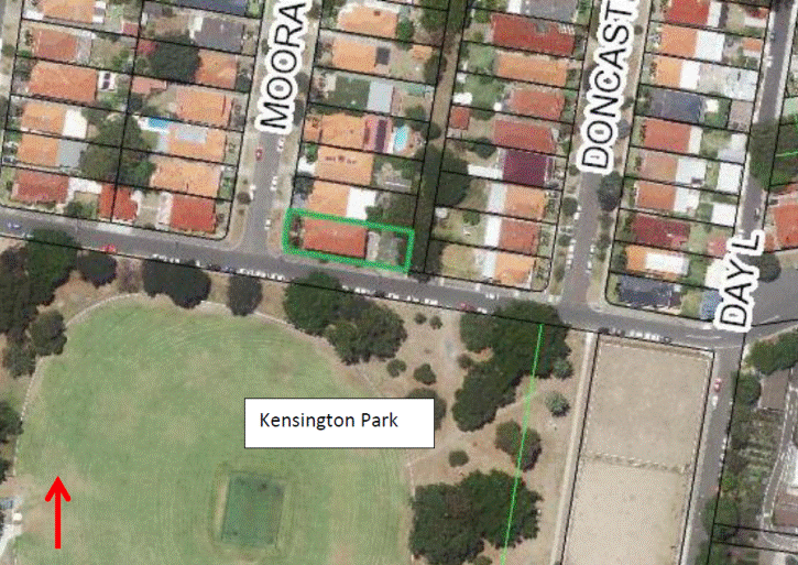
Aerial: Subject site (bounded in green) and the surrounding area. The site fronts Mooramie Avenue with a secondary frontage to Barker Street and is located approximately 350m from Anzac Parade and 280m from the Kensington Town Centre (B2 Local Centre zone). The regular bus services offered along Anzac Parade and proximity to the town centre mean the site qualifies as accessible site as required under the State Environmental Planning Policy – Affordable Rental Housing (SEPPARH) 2009.

Photo 1: View of the subject site from the western side of Mooramie Avenue
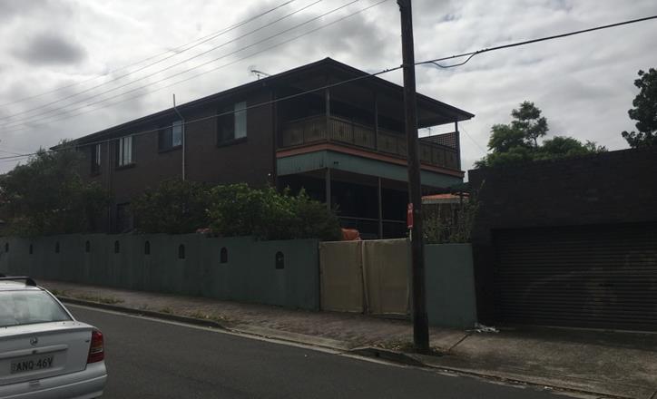 Photo 2: View of the rear of the subject site from the opposite
side of Barker Street.
Photo 2: View of the rear of the subject site from the opposite
side of Barker Street.
3. Site history
A review of Council’s files indicate that the property is currently approved as a dual occupancy, permitted to contain a two (2) storey residence and detached rear garage and single dwelling. The application history is summarised in Tables below.
Table 1: Development Application History
|
Date |
Application Reference |
Development Considered |
|
06.02.1989 |
539/89/D-355/88 |
Approval granted for the construction a new single dwelling and garage to the rear of No. 89 Mooramie Avenue to create a dual occupancy.
At the time of granting consent the existing dwelling (located to the front of the property) was identified as single storey. |
|
25.01.1993 |
539/89/D-535/92 |
Approved second storey addition to existing detached dual occupancy (front residence).
A specific condition (condition 5) was imposed restricting the use of each domicile to a single dwelling. |
The property was sold in mid-2013 at the time of sale indicative floor plans were provided showing the main residence having being converted into two (2) separate domiciles. Notably this adaption contravenes the conditions of consent 539/89/D-535/92. It is unclear at what point these works were undertaken.
Table 2: Most recent Development application
|
Date |
Application Reference |
Development Considered |
|
25.11.2015 |
DA/560/2014 |
Refusal of the proposed change of use into a boarding house for the following reasons:
The submitted documentation did not suitably articulate the illegal works carried out;
The proposed 17 lodger boarding facility was considered an over intensive use of the site and would result in significant adverse impacts on the neighbouring properties
The development was not considered accessible under the provisions of the Disability Discrimination Act 1992 |
|
Notes: The proposal is considered suitable for the locality and the delivery of affordable housing is generally supported.
It was considered by the assessment officer of the above DA that “If further application is made, it should be accompanied by a concurrent building certificate to regularise any unauthorised construction intended to be retained and seek to improve the plan and site layout by reducing the number of boarding rooms and residents”. |
||
4. Submissions
The owners of adjoining and likely affected neighbouring properties were notified of the proposed development in accordance with the Randwick Comprehensive DCP 2013. The following submissions were received as a result of the notification process:
· 34 Mooramie Avenue, Kensington
· 38 Mooramie Avenue, Kensington
· 40 Mooramie Avenue, Kensington
· 46 Mooramie Avenue, Kensington
· 48 Mooramie Avenue, Kensington
· 52 Mooramie Avenue, Kensington
· 54 Mooramie Avenue, Kensington
· 56 Mooramie Avenue, Kensington
· 58 Mooramie Avenue, Kensington
· 59 Mooramie Avenue, Kensington
· 60 Mooramie Avenue, Kensington
· 62 Mooramie Avenue, Kensington
· 64 Mooramie Avenue, Kensington
· 65 Mooramie Avenue, Kensington
· 66 Mooramie Avenue, Kensington
· 69 Mooramie Avenue, Kensington
· 75 Mooramie Avenue, Kensington
· 77 Mooramie Avenue, Kensington
· 79 Mooramie Avenue, Kensington
· 81 Mooramie Avenue, Kensington
· 83 Mooramie Avenue, Kensington
· 85 Mooramie Avenue, Kensington (Head Petitioner containing 26 signatures)
· 87 Mooramie Avenue, Kensington
· 205 Doncaster Avenue, Kensington
· Kensington & West Kingsford precinct
· Rapport Heritage Consultant
The issues raised in submissions received by Council are noted and assessment comments follow:
Issue: Residents and visitors will cause noise and disturbance to elderly residents and young families and the quiet and peaceful safe environment.
Comment: The premises are subject to management practices that will serve to ensure that the quiet enjoyment of the neighbouring properties will be reasonably protected. Additional conditions are also included to restrict use of the communal spaces so that they don’t occur between the hours of 10pm and 7am when sleep disturbance is more likely to occur. It is also noted that a management plan accompanies the application indicating that no parties will occur on site. Additional conditions have also been recommended for inclusion by Councils Senior Environmental Health Officer to minimise noise disturbance.
The safety of neighbours is not considered to be unduly impacted by the proposed use of the site as a boarding house for lodgers. There is nothing to suggest that the future occupants would pose a threat to the local community.
Issue: Increased numbers of transient people will bring increased noise at night when people want to relax
Comment: The 3 month minimum period of stay is not considered to represent a transient lodger. It is also noted that a nominated person is required to be responsible for the management of the boarding house. This person shall maintain a record of all residents with details of their names, length of stay & number of persons in each room. This information shall be stored for a minimum of 12 months on site and made available to Council Officer’s upon request.
Issue: The common room and TV room should be on the other side of the house as they are in close proximity to the bedroom of No. 87 Mooramie Avenue.
Comment: The common room is offset from the neighbour’s windows opposite and the TV room only contains a small window that is required to be treated with fixed obscured glazing to 1.6m above floor level. This will assist with noise attenuation. Notwithstanding, the use of the common rooms is restricted to the hours between 7am and 10pm thus minimising the potential for sleep disturbance. Locating these rooms during the parts of the day in which sunlight is most needed is not considered a good outcome.
Issue: There isn’t enough visible landscaping on site and removal of more trees
Comment: The landscaping provided on site is considered reasonable particularly in relation to the amount retained within the front yard with two trees being retained. See also key issues section under Part C1 – Low Density Residential - Landscaping and Permeable surfaces.
Issue: Waste bins should be located in the outbuilding. The proposed location of the waste bins will create smells to the street, park and BR3 and the rear balcony. Locating bins on the first floor landing is unsafe.
Comment: The location of the waste bins is considered acceptable and not considered to have any significant impact on odours to the street, parkland or BR3. A condition is also included requiring adequate provisions to be made within the premises for the storage, collection and disposal of waste and recyclable materials, to the satisfaction
of Council. There is no waste being located on the first floor landing, this is a cleaners room.
Issue: The acoustic study does not address noise from the use of the premises as a boarding house. The large number of students or boarders plus visitors at all hours will cause noise disturbance.
Comment: The acoustic report has been submitted with the application and is considered to suitably address the required noise source that is mechanical plant and equipment from the premises. In relation to lodger and visitor noise, these are considered to be adequately attenuated by the management plan, inclusive of house rules and other conditions of consent relating to behaviour and permitted use of communal space areas within the site. It is also considered that relocating the entry gate to the southern side of the building lessens the potential for noise disturbance from lodgers or visitors entering the premises during hours where sleep disturbance occurs. The reduction of lodgers from 11 down to 9 will also assist as will the removal of the boarding room BR9 from the outbuilding.
Issue: The removal of the first floor common room will mean more use of the first floor balconies.
Comment: As indicated the use of the premises if adequately managed will not result in any unreasonable noise impacts on the neighbouring properties.
Issue: Room BR9 within the outbuilding will be subject to fumes and fire hazard.
Comment: it is considered that the amenity of BR9 within the outbuilding is poor due to its only window facing the communal open space area and because of the proximity to the parking facilities.
Issue: The rear garden is too small and doesn’t appear to have the required width when considering the access path located alongside it
Comment: The communal open space in the rear yard is considered to be of a suitable width and area to provide suitable amenity for the occupants of the premises. It is noted that the communal open space provided represents an area of 2.2sqm per lodger which is greater than the 1.2sqm minimum required. It is also noted that there are multiple areas within the site that are capable of providing other options for the use of open space.
Issue: The number of lodgers should be reduced to reduce impacts on neighbouring properties.
Comment: The number of lodgers was firstly reduced from the 17 lodgers proposed under DA/560/2014 which was refused by Council. The original number of lodgers sought as part of this application was 11; however this was reduced by 1 lodger down to 10 as a result of the shortfall in the size of room BR4. A further reduction of 1 lodger as a result of the required deletion of BR9 within the outbuilding means that the total number of lodgers within the boarding house is reduced by 2 lodgers down to 9.
Issue: Residents from the upper floor will eat and socialise on the upstairs balcony particularly during bad weather causing noise to surrounds
Comment: The use of all communal open space areas is conditioned to only be permitted between 7am and 10pm hours where sleep disturbance is unlikely to occur.
Issue: The windows of No. 87 Mooramie Avenue are very close and windows near the neighbours should be properly fire treated.
Comment: The requirements for fire protection are a prescribed requirement under the Building Code of Australia (BCA). All openings will be required to comply with the deemed to satisfy or alternative solutions requirements under the BCA for fire safety and protection of neighbouring properties.
Issue: The constant shorter term stay of lodgers in a boarding house will conflict with the capacity for use to get to know our neighbours and to allow us to feel safe. The boarding house will feel like a hotel in the street. This type of accommodation should not be in the R2 zone.
Comment: The boarding house is permissible in the R2 zone under both the SEPPARH and the Council RDCP. A hotel is a use that would permit only short terms stays from a few hours and it is only permitted in certain local centres within Randwick LGA. The management and operation of the premises will require the lodger’s registration to be kept on-site.
Issue: The share room arrangement promotes short term accommodation and not long term housing.
Comment: The share room arrangement does not necessarily promote shorter term accommodation. Notwithstanding, it is noted that there are only two rooms in the premises that would be capable of accommodating double lodgers. These rooms would also be usable for a couple of students or friends.
Issue: The first floor has many people sharing rooms and no eating or dining area so boarders will have to use the balconies more, creating more noise for neighbours
Comment: The first floor contains only one shared room (BR8). The originally proposed double lodging of BR4 has since been amended by the applicant to house only one lodger as the room size was smaller than 16sqm. There are a total of five lodgers using the first floor level and it is considered that in combination with the area within the kitchen, and the first floor balconies at the front and rear that there is sufficient areas for the purposes of having a meal. It is further considered that the management of the premises and restrictions on use of the outdoor spaces during late night periods that the amenity of neighbouring residents will be protected.
Issue: With the 11 lodgers, high turnover and no manager on site the potential for impacts is greater and more likely complaints
Comments: The number of lodgers is reduced down to 9, a condition is included requiring a nominated person is required to manage the premises. It is considered that if the property is managed effectively and efficiently that this will lessen the need for complaints to be made and therefore investigated by relevant authorities.
Issue: the management plan seeks to rely on neighbours to complain which is unreasonable.
Comment: Noted, however the complaint procedure is aimed at reducing the potential for conflict between the proposed uses carried out on site and to promote the orderly use of the site. Thus, the complaint procedure amongst also house rules encompassed within the management plan seek to ensure that the premises is run as efficiently and effectively as possible without resulting in any unreasonable adverse impacts on the amenity of neighbouring properties and the surrounding area.
Issue: Boarders and friends will be parking in the street creating higher demand for on street parking
Comment: The proposed parking for the boarding house complies with the SEEPARH standards for parking. Under the SEPPARH, explicitly prohibits Council from refusing an application on parking grounds if it meets those standards. It is also important to consider that the premises meets the criteria as an accessible site as it is within 400m of both an accessible transport route and a town centre which would lessen the need for vehicle ownership by lodgers.
Issue: The number of people proposed is out of proportion with other houses and number of occupants within each dwelling.
Comment: The boarding house is conditioned to be limited to a maximum of 9 lodgers which is not considered an inordinate number when considered in the context of a dual occupancy premises to which it currently has approval for.
Issue: If passed the outdoor areas should be limited to 9pm
Comment: The outdoor areas are limited to up to 10pm and not before 7am. These are considered to be reasonable restrictions for the quiet enjoyment of neighbouring properties
Issue: Concerned with overlooking into neighbouring properties
Comment: The proposed development contains adequate privacy measures inclusive of the use of screening along the northern side of balconies. The rear balconies which are most susceptible to resulting in overlooking to the northern neighbour’s property at No. 87 Mooramie Avenue have privacy screens that wrap around to their rear elevations ensuring the outlook is further minimised to limit overlooking to the rear most sections of this neighbours rear yard which is not an inordinate outcome having regard to privacy within the urban context. In relation to the neighbours at the rear it is considered that the 20m separation to their boundary provides sufficient separation for the purposes of privacy protection.
Issue: How would the residents escape the building if there was a fire on the 1st floor as there is only an exit through the front door on the ground floor.
Comment: All rooms within the first floor level are separated from the travel path and required to have a fire bounding construction to comply with the BCA and Australian Standards
Issue: The illegal building is still part of the DA
Comment: The illegal works carried out are merely there to identify the works that do not form part of the DA and therefore the Construction certificate. If the development is considered suitable for boarding house use then these works will be required to be appropriately certified prior to any further works being carried out.
Issue: the front entry must be maintained for safety and security
Comment: The relocated entry to the southern part of the site is still located in close proximity to the front boundary of Mooramie Avenue. It is considered that relocated front entry to the secondary street frontage reduces the potential for amenity impacts on neighbouring properties also.
Issue: Wil this application set a precedent for other similar uses in the area therefore transforming the character of the area.
Comment: Every application is assessed on its merits. It is considered that the subject site is suitable for the proposed use as amended and as conditioned. It will achieve good planning outcome having regard to satisfying the requirements under the SEPPARH and the relevant controls under the RDCP and RLEP.
Issue: The proposed boarding house adds considerable noise, traffic and parking in the street which have already been felt from the UNSW expansion.
Comment: The site is capable of accommodating the proposed use on site, which is smaller than that originally proposed. The surrounding area is in close proximity to a Local Centre contains a number of service industries such as health and education. This location lends itself to being used for the purposes of a boarding house and will not subject to compliance with relevant conditions will not result in any significant or unreasonable adverse impacts on the neighbouring properties.
Issue: The privacy screens on the verandahs will not restrict noise impacts
Comment: Acknowledged however this area is sited alongside a living area on the adjoining site and not considered to result in any significant noise impacts on the neighbouring properties living area.
Issue: Request that council imposes the highest standards on boarding house proposals to protect the visual, acoustic, social, environmental amenity of surrounding residents and make no concessions unfavourable to long term residents when compared to boarding house developers who seek short term development yield.
Comment: Council is charged with assessing the application for a boarding house within policy guidelines. The assessment is carried out against these relevant standards guided by Section 79C of the Environmental Planning and Assessment Act and its regulations. These policies and guidelines consider the amenity of residents in the surrounding area.
Issue: Who is the owner accountable to in relation to ensuring the noise and management plans are adhered to and what sanctions will apply.
Comment: Having regard to the SEPPARH, the number of boarding rooms within the premises does not require an onsite manager. Notwithstanding, a condition is included requiring that a person be nominated to be the manager for the premises. Whilst this does not require them to be on-site it does however require that a person be charged with adhering to the management plan and associated conditions of consent. In relation to the sanctions, there are certain regulations that Council can rely on that would be directed to the owner of the premises.
Issue: The management plan will not be able to adequately manage noise as with shared rooms lodgers will want to go somewhere else to talk when their roommate is studying or sleeping. We believe that the noise can only be managed by reducing lodger numbers.
Comment: There are ample areas within the premises for the purposes of talking. As noted the communal open space areas provide suitable areas for said purposes as do the internal communal areas and these are appropriately restricted.
Issue: The overall plan does not fit in with the concept of good eco-living conditions it is overcrowded, congested and noisy
Comment: The plan is accompanied by a BASIX certificate ensuring the ecologically sustainable development measures are being satisfied. Aspects such as solar access and generally amenity are considered throughout the assessment of this report. It is considered that the rooms are of a sufficient size that they are able to sustain lodging for 9 lodgers.
Issue: The plan for the TV room is very small, how many people would fit in there
Comment: The TV room is not required to fit all lodgers, provides an alternate passive activity within the communal living areas of the boarding house.
Issue: All the rooms are too small and will not be lodged for long periods
Comment: The room sizes are suitable for the number of occupants (9) and suitable amenity will be afforded for future occupants of these rooms.
Issue: The proposed screens of the balcony will result in the loss of view of the park from the lounge room living room facing south
Comment: The screens will result in loss of outlook from their window however it is a sideways view across the subject site – see photo 3 below. These side views are not easily protected having regard to the view sharing planning principle set out by the Land and Environment Court. There will also be views of the park that are retained in a more rearward diagonal angle across the subject site from this neighbour’s window – see photo 4 below. It is also noted that the development in terms of its size and scale is compliant with the relevant RLEP and RDCP controls for side and rear setbacks and heights.
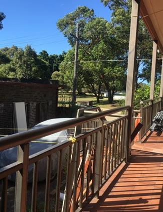
Photo 3: showing views from the neighbour’s south facing living room window that will be lost as a result of the installation of privacy screens along the northern and eastern side of the ground level balcony.
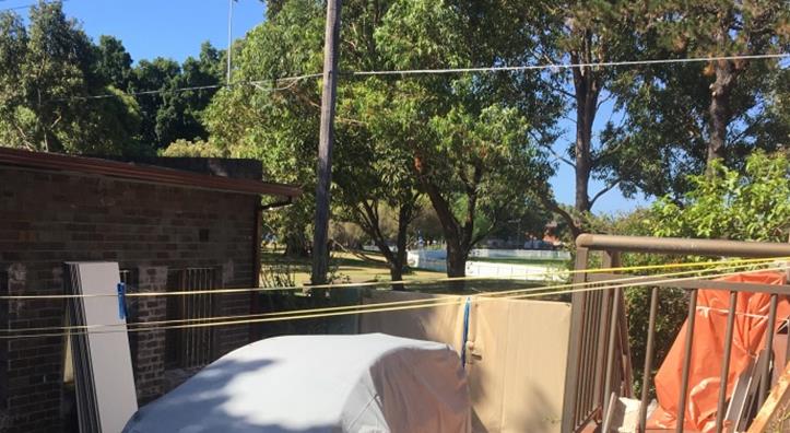
Photo 4: showing the view of park from the same level of neighbour’s south facing living room window. Note: The photo is taken from within the subject site at a height at which an unobstructed view will be retained from this neighbour’s living room window in a sitting position.
Overall, having regard to the view sharing planning principle provided by the Land and Environment Court, it is considered that the proposed development will achieve a reasonable level of view sharing. In other words, the view loss of the park from the neighbour’s living room window is acceptable, there will be retained views of the park that are of reasonably good quality and the proposed size, and location of the development represents a reasonable development having regard to the relevant planning policies and guidelines.
Issue: The following windows appear to have been altered and do not appear to be the original dimensions:
· Ground level north facing common room window
· First floor level north facing boarding room (BR5)
These windows result in adverse privacy impacts.
Comment: The ground level common room window dimensions have been altered slightly at the header and a condition is included ensuring the works carried out to the header do not form part of the consent. There does not appear to be works that have been carried out to the first floor window to boarding room BR5.
· Common room window: In relation to the common room window it is slightly offset from the neighbour’s window and in order to ensure sufficient visual privacy a condition is included requiring an external screen to 1.6m above the internal floor level to provide greater levels of privacy to the northern neighbours windows.
· BR5 window: Window to BR5 a first floor level room is on a higher horizontal plane to that the northern neighbour’s lower ground level window and therefore suitably offset to ensure no significant privacy impacts.
Issue: First floor boarding room Window to BR4 will affect my future development of No. 87 Mooramie Avenue
Comment: BR4 is a relatively small window and it is not anticipated that the total number of north facing windows at first floor level is either excessive or would unreasonably affect the future first floor addition to No. 87 Mooramie Avenue
Issue: there is only one common room and is likely to be the location for parties and gatherings within the house
Comment: The management plan indicates that the premises are restricted from having parties within the premises. Notwithstanding, gatherings may well occur as this is an area in common. However it is important to also consider that the common room window is offset from the windows on the southern elevation of the dwelling opposite and further there are restrictions on the use of this room within certain hours.
Issue: Fire separation works are not intended to be carried out
Comment: The applicant has submitted a satisfactory and comprehensive Fire Engineering report including alternative solutions and also a BCA report accompany the application.
Issue: The accessibility to the manager from between 8am and 10pm does not factor the likely periods in which the manager may be called upon to ensure that the premises is operating within acceptable boundaries in terms of noise and occupant behaviour.
Comment: The necessity for 24 hour on call manager is considered onerous for the purposes of a boarding house containing a maximum of 9 lodgers.
Issue: If the boarding house facility is approved it should be reduced to a maximum capacity of 5 lodgers
Comment: The 9 lodgers as conditioned is considered suitable for the site and a recommendation is made for an approval subject to appropriate conditions being imposed
Issue: The revised plans still fail to differentiate between the unauthorised works commenced by the applicant and other unauthorised works carried out by previous owners.
Comment: An inspection of the site reveals that the works carried out have been documented as shown on the submitted plans. It is not considered that
Issue: The calculations provided by the applicant are incorrect
Comment: The calculations have been carried out independently and the applicant has further acknowledged as such and it is noted that the additional soft landscaping provided is increased to counteract the loss of landscaping at the front.
Issue: The proposed development does not qualify as accessible under the Disability Discrimination Act having regard to the internal communal area and the rear private open space areas
Comment: See comments under disability discrimination act in the key issues section of this report.it is noted that certain measures have been documented in this key issues section of this report. These works are considered to adequately address the requirements under the Disability Discrimination Act and a suitable condition is included. These works are also minor and will not result in any adverse impacts on the amenity of neighbouring properties.
Issue: The communal room measures less than 20sqm excluding the TV room
Comment: it is considered that the opening between the communal room showing a table and chairs should be considered as including the TV room which totals 20sqm
Issue: The lack of communal room at first floor level will mean more noise to boarding rooms within the development
Comment: The boarding room adjacent to the areas of private open space at first floor level includes only BR8 at the rear and BR4 at the front. BR4 has no window openings to the private open space and is therefore suitable protected. BR8 does have a window opening to this area. It is considered that for the purposes of amenity within the room that the restrictions on the use of the first floor level balcony to between 7am and 10pm will allow for reasonable levels of privacy during sleep periods.
It is also noted that this is not the only window that provides light to the room as it also has a window that is unobstructed by buildings opposite but has a relatively open view across to large areas of open space.
Issue: tenants will cook in their rooms creating a fire hazard
Comment: There are no cooking facilities in any boarding rooms.
5. Key Issues
The following section of this report contains an assessment of the key issues of relevance to the subject application.
5.1 Unauthorised works
It was noted by the assessment officer of the previous development application (DA/560/2014) that following an inspection of the property combined with a review of the last known floor plan layout of the dwellings there was much more unauthorised works that had taken place than that shown on the plans submitted with the application. Due to this lack of clarity in identifying the extent of works that have taken place and the restriction placed on Council to retrospectively approve any such works the application was required to be refused.
The submitted plans as part of this application suitably document the extent of unauthorised works and where necessary suitable conditions are included encompassing the works to the header of ground level common room window.
Should a recommendation be made for approval, an appropriate condition will be included excluding the illegal works from the determination. These unauthorised works will be the subject of Council’s Building and Regulatory Services Section who will be required to ensure that there are no BCA or fire safety implications and that they are structural sound which will be required to be completed prior to a Construction certificate being issued for the proposed works encompassed within this application.
5.2 Disability Discrimination Act 1992
The previous development application contained certain elements that did not comply with the Access to Premises standards or the Building Code of Australia in relation to minimum access requirements. These elements have been rectified by the subject application as follows:
· A continuous path of travel is now provided to the rear of the property and between the detached outbuilding and the main dwelling for mobility restricted persons.
· The common areas including the internal communal room and shower and laundry facilities are now accessible by virtue of the increased width of openings
The applicant has furnished a letter of recommendation from GN Consulting, dated 05/03/2015, indicating that the proposed development will, satisfy the relevant requirements under the Part D3 of the BCA 2014, and other standards for Access and Mobility subject to the following works:
- Relocation of the pedestrian entrance to the southern side of the dwelling;
- Increase in width of openings to no less than 850mm;
- Removal of an existing Avocado Tree near the front of the property;
- The design of all ground surfaces
- Increase in width of rear stairway to 1000mm minimum
- Installation of threshold ramps at the doors leading to private open spaces at the front and rear
- Provision of braille signage for accessible facilities and exits
- Install handrails on the principle pedestrian ramp and increase width of the landing
- Locate all switches and door handle to between 900-1100mm above the finished floor level.
These works are minor and there are no objections to these works being carried out.
In relation to the Avocado tree it is considered that the site is able to sustain the loss of the Avocado Tree and the retention of two trees in the front yard ensure that suitable landscaping and open space is retained at the front to soften the development from street level.
Outbuilding
It is noted that the recommendation by GN consulting indicates that the Class 1b outbuilding is not included in their assessment. This is not fatal to the application in so far as the amenity of the room (BR9) is poor and therefore required to be deleted from the application as a condition. This room will be limited for use as a store room.
Overall, it is considered that the requirements under the Disability Discrimination Act 1992 are satisfied and should approval be recommended a suitable condition shall be included requiring compliance with the associated documentation from GN Consulting and required deletion of Room BR9.
5.3 State Environmental Planning Policy (Affordable Rental Housing) 2009
Division 3: Boarding houses
The subject application is made pursuant to the SEPP (Affordable Rental Housing) 2009 and its relevant clauses. The key clauses are addressed as follows:
· Clause 26 of the SEPP provides that Boarding Houses under this Division are permissible within the R2 Low Density Residential zone.
· Clause 28 stipulates that such development may be carried out with consent.
· Clause 29 provides standards that cannot be used to refuse consent and
o Clause 29(3) Landscaped area
Landscape treatment is required if the front setback area is compatible with the streetscape in which the building is located.
The main built form remains setback from the Mooramie Avenue frontage with the only new element located between the existing building and front boundary being the external access ramp.
The proposed ramp is considered acceptable having regard to the requirements under Clause 29(3) for the following reasons:
It is located at ground level and will not be immediately noticeable from street level
The front setback of the development from the Mooramie Street frontage will remain retaining generally consistency with the prevailing setback in this section of the Street.
The application now retains two of the three existing trees in the front yard, with the Avocado tree required to be removed, providing suitable landscaping and open space fronting Mooramie Avenue ensuring the open spaces will be compatible with surrounding development.
o Clause 29(d) Private open space
The proposed development includes 1 communal area in the rear yard measuring 24sqm between the outbuilding and the rear decks thus complying with the minimum requirements under the SEPPARH. The rear yard has minimum dimension of 3m which encompasses the garden bed. Notwithstanding the trafficable area in the rear yard only has a minor shortfall which is largely a consequence of the requirement for an access ramp to address the inaccessibility issue identified in the previous application considered by Council DA/560/2014.
It is also important to note that under the SEPPARH the areas of open space do not exclude the garden beds or access areas. It is also important to consider the amenity of the area of private open space and whether there are alternative areas within the premises that would allow for suitable areas for this purpose. In this respect, the site contains suitable amenity for the purposes of private open space in the rear yard with good amenity. In addition. The boarding house also provides additional private areas for the lodgers at the rear ground and first floor level balconies as well as the front ground and first floor level balconies. In addition, the site is also opposite Kensington Park which also provides the capacity for more active recreational uses.
o Clause 29(f) Accommodation size
This section of the SEPPARH requires that each boarding room has a gross floor area (excluding any area used for the purposes of private kitchen or bathroom facilities) of at least 12sqm for a single lodger and 16sqm for any other case.
The ground level room BR4 has an area less than the required 16sqm and is therefore required to be a single lodger room. The applicant acknowledged as such and submitted amended first floor plan showing only one bed is located within this room. There are two rooms with areas above 16sqm allowing double lodgers (BR3 & BR8).
A suitable condition shall be included should a recommendation be made for approval
· Clause 30 prescribes that a consent authority must not grant consent to a development unless it is satisfied that certain standards for boarding houses are being met.
o Clause 30(a) Communal living room
The SEPPARH requires that “If a boarding house has 5 or more boarding rooms, at least one (1) communal living room will be provided.
A communal living room has been provided within the building at ground floor level. The proposed communal living room is located at ground level allowing for both passive TV viewing and a larger area with table and chairs allowing for more active communal interaction. Under the previous application (DA/560/2014) the communal living rooms were not considered to contain adequate amenity as they were two rooms that did not meet the minimum requirements under the RDCP for size, they were inappropriately located for the purposes of good amenity and they didn’t allow direct accessibility.
The communal room now contains a size and is located adjacent to the kitchen ensuring that it provides reasonable amenity for the purposes of the RDCP controls and objectives. The amenity of boarding rooms and their location relative to the communal room will be discussed further below under the RDCP key issues relating to the application.
· Clause 30A requires the consent authority is required to take into consideration whether the design of the development is compatible with the character of the local area.
o Clause 30A - Character of the local area
An assessment is carried out in relation to the context, compatibility of the built form, compatibility of the use and compatibility of the R2 zone
Context:
The site has a frontage of 10.215m to Mooramie Avenue, a 39.015m secondary frontage to Barker Street and a total site area of 589.7sqm.
To the north, west and east the site is surrounded by detached dwelling houses. Further to the east on either side of Houston Road are properties zoned R3 medium density residential allowing for smaller scale residential flat buildings that also permit boarding houses with a bonus of 0.5:1 FSR allowed under the SEPP ARH 2009. Further eastward, the site is located within 300mm of the Kensington Town Centre along Anzac Parade that allows for developments with a height limit of 24m. The UNSW located on the eastern side of Anzac Parade contains large elements of student accommodation. The site is located approximately 6km from the Sydney CBD.
The locality is occupied by a mix of low to medium density residential and infrastructure type land uses of a built form and spatial separation that is comparable to and compatible with the proposed development.
The following image demonstrates the zoning context.
|
Zoning context |
|
|
Compatibility of built form:
When viewed from Mooramie Avenue, Barker Street and surrounding properties the development will read as a 2 storey dwelling as shown in photo 1 below.
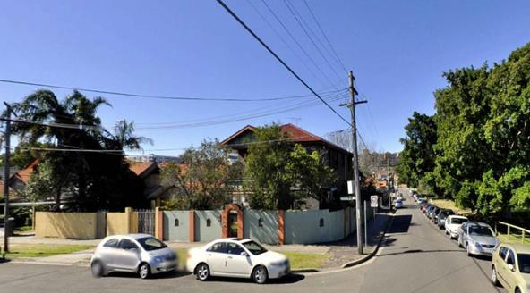
Although the proposed development does not meet the minimum landscaped area required for dwellings by the RDCP 2013, the development continues to contain suitable trees between the front ramp and the front boundary, additional deep soil areas have been provided such that it will not be discernible from street level. In essence, the proposed development will not affect the discernible spatial separation that currently exists at the front of the site and it will not be inconsistent with the predominant front building line or setbacks along this side of Mooramie Avenue or the secondary street frontage. The proposed ramp which is the reason for the shortfall in landscaping and one of the reasons for refusal of the previous development application before Council is lessened by the provision of additional deep soil, retention of two trees within the front setback of the development and the loss of only one tree to provide disabled access ramp in the front and along the secondary street frontage.
It is noted that the nearby R2 and R3 zoned properties surrounding area allow for a maximum FSR of 0.75:1 and a height limit of 9.5m. Within this context, the proposed development is entirely compatible.
Compatibility of use:
The proposed use of the site, which comprises boarding house with 8 rooms and a maximum of 9 lodgers (reduced from the 11 initially proposed), constitutes a permissible form of development one that is envisaged by the SEPPARH 2009. Effective measures in relation to operation and management of the boarding house have been employed in a Plan of Management. These measures are recommended for enforcement by way of an appropriate condition of consent and will ensure that the development results in sustainable amenity impacts to adjoining residents. The proposed development will provide affordable housing to the community in a location within close proximity to the University of NSW, public transport, and commercial centres integrating effectively into the evolving character of the locality.
Consistency with the objectives of the Residential R2 zone;
The proposal is clearly consistent with the objectives of the zone, detailed as follows:
· To provide for the housing needs of the community within a low density residential environment.
· To enable other land uses that provides facilities or services to meet the day to day needs of residents.
· To recognise the desirable elements of the existing streetscape and built form or, in precincts undergoing transition, that contribute to the desired future character of the area.
· To protect the amenity of residents.
· To encourage housing affordability.
· To enable small-scale business uses in existing commercial buildings.
The physical impacts on surrounding properties are negligible and the RDCP section of this report is assessed as acceptable subject to appropriate conditions of consent. Furthermore the appearance of the proposed development will not markedly be changed and will remain be in harmony with the existing nature of the streetscape.
The local character test is satisfied on this occasion.
5.4 Randwick Local Environmental Plan (RLEP) 2012
The subject site is zoned R2 Low Density under Randwick LEP 2012. The proposal development is classified as a boarding house and is permissible in the zone. The proposal is consistent with the objectives of the zone and satisfies the key provisions under Clause 4.3 relating to building heights, Clause 4.4 relating to Floor space ratio and Clause 5.9 Preservation of Trees. In relation to trees which were a key issue of the previous application (DA/560/2014), the subject application now retains two of the three trees previously sought to be removed from the front yard.
5.5 Randwick Development Control Plan (RDCP) 2013
A detailed assessment of the proposed development against the relevant provisions of the Randwick Development Control Plan (RDCP) 2013 is included in the attachment to this report.
The key provisions of the relevant sections of the RDCP are addressed in this report.
It is noted that the DCP provisions are structured into two components, Objectives and Controls. The Objectives provide the framework for assessment under each requirement and outline key outcomes that a development is expected to achieve. The controls contain both numerical standards and qualitative provisions. Any proposed variations from the controls may be considered only where the applicant successfully demonstrates that an alternative solution could result in a good planning and urban design outcome.
5.5.1 Part C4: Boarding Houses
Under Clause 1: Boarding rooms of this part of the RDCP the following are identified as key measures to be considered in the assessment of the application for the boarding house/facility:
· Sunlight access
A key consideration of boarding room amenity is if they are orientated to receive the maximum amount of sunlight;
The proposal provides a northern aspect to only 3 of the 7 rooms with four rooms BR2, BR3 and BR6 & BR8 facing south and therefore do not have direct access to sunlight.
Despite this it is considered that the amenity and light provided within these rooms is considered suitable for the following reasons:
o The development is an adaptive reuse of an existing dwelling for the purposes of a boarding house and requiring all rooms to have a northern aspect is considered onerous in the context of the sites orientation
o The south facing rooms have much greater capacity for obtaining natural light with generally unobstructed outlook from their windows due to the fact that they do not have any neighbouring dwellings opposite and will thus allow for substantial natural light.
o The development includes three four areas of open space that are capable of receiving direct solar access
o The development also includes a communal living room that also retains more than minimum levels of direct solar access
Overall it is considered that arrangement of rooms for the purposes of sunlight is acceptable given the circumstances of the site.
· Safety and Crime Prevention
Another key consideration of boarding house design relates to whether there are suitable safety and crime prevention measures designed within the development. A key control is that building entry points and internal entries to living areas are located where they are clearly visible from common spaces.
The development seeks to locate the building entry point to the southern side elevation away from the front western elevation facing Mooramie Avenue (where it currently exists). This does not satisfy the control under Part C1 of the RDCP for low density residential development which requires that entries be located at the front elevation for the purposes of adequate casual surveillance.
Despite this it is considered that the casual surveillance of the street and the site is reasonable for the purposes of safety and crime prevention for the following reasons:
o The site currently has a high fence which already restricts sightlines to the street and the front entry through small openings within the existing fence. In order to not restrict this further a condition is included requiring only low-lying shrubs that do not interfere with sight lines nor provide opportunities for concealment or entrapment.
o Habitable boarding room at the front allows for casual surveillance to and from the front along Mooramie Avenue
o The southern side which is elevated above secondary street level footpath allowing for casual surveillance to the entry gate, and from communal open spaces at the rear
o The development locates habitable living areas (such as lounge room, kitchen, dining or bedroom) to allow general observation of the street and communal open space within the site itself;
Overall, the proposed adaptive reuse of the existing dwelling for the purposes of a boarding house will generally incorporate adequate safety and crime prevention:
· Visual and Acoustic Amenity and Privacy
The controls and objectives for visual and acoustic amenity and privacy are guided by both the SEPPARH and under the following sections of the RDCP: Part C4 Boarding Houses, Part C1 Low Density Residential and Part B9 Management Plan. The key controls and objectives under the SEPPARH and the RDCP are outlines as follows:
The key controls under the SEPPARH are:
· Indicative locations of facilities and appliances for bathrooms, kitchens and laundries must be clearly shown on the DA plans/drawings;
· Locate kitchen, dining room, lounge room and outdoor open space adjacent to or directly accessible from each other;
· Locate similar uses (such as bedrooms or bathrooms) back to back, to minimise internal noise transmission;
· Bedrooms are generally located above each other except for bedroom 5 (1st floor), which is located above the communal room.
The key objectives under the RDCP for are:
· To locate communal open space, balconies and windows to bedrooms or communal areas, to minimise overlooking, privacy and acoustic impacts on adjoining properties;
An assessment of the visual and acoustic privacy of the boarding facilities in relation to the above SEPPARH and RDCP objectives is carried out as follows:
o Window privacy on neighbouring properties
The window that may have an adverse visual privacy impact on the neighbouring property is the TV room window and the common room window. These have an outlook across to the neighbour’s habitable room window (in the middle of their southern elevation). A suitable condition is included requiring these windows to be suitably treated ensuring no downward direct overlooking.
o Balcony privacy on neighbouring properties
The proposed development contains suitable 1.8m high screening to parts of balconies which may have a direct and obtrusive view into the neighbouring properties. These screens are conditioned to be designed to ensure reasonable levels of visual privacy to neighbouring properties
o Acoustic Amenity within the boarding facility
The assessment of the previous application for a boarding house considered that in certain areas of the facility, the internal layout resulted in poor acoustic/noise amenity for the occupants of the premises. The subject application has substantially addressed these issues and an assessment of the areas considered in the previous application is also considered in the current application which has substantially reduced the number of lodgers using the premises. The internal acoustic amenity of the premises is assessed for the facility’s areas as follows:
Ground level:
- Ground level boarding room (BR1) had a window and common wall to the proposed communal area; the bedroom window is now filled in and whilst the wall is still adjacent to the private open space it is not considered that any adverse acoustic amenity will result.
- Ground level boarding room (BR2 - previously BR4) had a common wall to the shared entry foyer/communal area and kitchen; the communal area has been relocated away from this foyer entry area and suitable management ensures that the occupants of BR2 will not be unreasonably impacted its location adjacent to the entry and kitchen. It is noted that there are only three boarding rooms at this level and it is not anticipated that the location of the BR2 would be unduly impacted in terms of its amenity. Further the room is for a single lodger and it is anticipated that alternative arrangement of the bed is possible within the room to provide better amenity.
- Ground level boarding room (BR3) is located between the common kitchen and rear verandah, BR3 remains located in this position between the kitchen and rear verandah; the occupant’s amenity can be reasonably protected by the management of these areas of the site during the late night periods.
- Ground level boarding room (BR2) was located between common laundry kitchen and en-suite bathroom of boarding room BR1; this boarding room is now replaced with an internal communal room.
First floor level:
- First floor boarding room (BR5 – previously BR7) is located between an en-suite and the laundry. This matter has been raised in a submission. It is not considered that this is a significant concern in so far as the laundry elements are located on the far wall away from the bedroom and the en-suite suite is located adjacent to the en-suite for another boarding room (BR4). Suitable amenity will be retained within this room. Whilst BR5 remains adjacent to the laundry and opposite the kitchen it is considered that there is sufficient separation from the kitchen. As well this room which was previously a double lodger room is now single lodger room readily allowing for bed placement away from the adjacent laundry. Further still, appropriate management of the facility will minimise adverse acoustic amenity impacts.
- First floor boarding room (BR6) is located between the kitchen and cleaners room. As is the case with BR2 on the ground level there are no major concerns with the amenity within this room as it is likely that the cleaner’s room would not be used during late night periods and further there is ample area within the room to configure the bed for least impact.
Outbuilding
- Outbuilding boarding rooms BR5 and BR11 were inappropriately located adjacent to communal kitchen and share a common wall with parking areas. Boarding room BR5 is now removed from within the outbuilding and the subject application relabels BR11 now as BR9 with a reconfigured internal layout for the outbuilding contains a communal kitchen and laundry. The internal layout of the outbuilding relative to boarding room BR9 is considered to contain very poor amenity and conditioned to be deleted for the following reasons:
o This room is directly opposite the kitchen with no appreciable separation,
o It’s only window is directly opposite the communal area of open space in the rear yard
o It’s in a direct pathway to and from the parking area which cannot be appropriately managed to minimise impacts
A condition is therefore included requiring the deletion of boarding room BR9 from the development and replaced with a store room only.
Overall, subject to a condition requiring the deletion of boarding room BR9, the internal amenity of boarding rooms is considered adequate.
o Acoustic amenity of neighbouring properties
The SEPPARH requires that the acoustic amenity of neighbouring properties is reasonably protected. The RDCP also requires the same and requires that an acoustic report prepared by a suitably qualified acoustic consultant must be submitted for new development or conversions/intensifications with an increase in resident numbers.
The application includes a noise impact assessment report which has been reviewed by Councils Senior Environmental Health Officer. Councils Health officer raises no objection to the proposed development on the grounds of acoustic amenity of neighbouring properties subject to the inclusion of conditions to suitably ameliorate acoustic impacts. These conditions include but are not limited to the requirement for an updated acoustic report following operation to ensure compliance with the applicable noise criteria, certain restrictions on the use of communal open space areas. In this respect, the application is also supported by a Plan of Management that includes restrictions on the use of outdoor spaces by residents to the hours between 7am and 10pm outside of which are most susceptible to result in noise disturbance and restricting the playing of music, parties or visitors after 10.00pm.
Overall, it is considered that the subject application has reasonably considered the visual and acoustic amenity within the subject site and that of the neighbouring property namely that of No. 87 Mooramie Avenue.
5.5.2 Management plan (Part C4 and Part B9 of the RDCP 2013)
The RDCP under Part C4 Boarding houses and Part B9 Management Plans sets out the requirement and contents of a Management Plan to be submitted with all DAs for new and existing boarding houses. Management plans are required to address the general requirements outlined in the Management Plan section in Part B, which includes the following matters:
· Selection of residents with preference for people on low and moderate incomes;
· Furnishings;
· House rules, covering issues such as lodger behaviour, visitor and party policies, activities and noise control, use and operation hours of common areas (e.g. communal open space and living rooms) and policies for regulating smoking and consumption of alcohol and illicit drugs;
· Cleaning and vermin control arrangements for shared facilities and
· Public notice and signs
A plan of management and House Rules accompany the application and it is generally considered to suitably address the requirements under Part C4 and Part B9 of the RDCP 2013. Adherence to the management plan and additional matters will be a conditional requirement and serve to ensure the operation of the boarding house will not result in any significant or unreasonable adverse impacts on the amenity of neighbouring properties and the surrounding area.
5.5.3 Part C1 Low Density Residential
As indicated in the previous assessment, landscaping is the subject of a separate specified control under the provisions of SEPPARH to which it is considered to comply. Notwithstanding, reference is made to the landscaping and permeable surfaces section of this part of the RDCP as it contains the objectives that are required to be satisfied for the purposes of low density residential development.
· Landscaping and permeable surfaces
The proposed development has 17.8% of the site provided as deep soil area and would not meet the 30% minimum area required for low density residential development under the RDCP 2013.
The relevant objectives under this section of the RDCP are:
· To ensure landscaped areas are effectively distributed on the site to achieve a visual balance between building structures and open space.
· To provide privacy screening between dwellings.
· To retain and provide for canopy trees and large shrubs to contribute to the establishment of vegetation corridors across the locality.
· To assist with stormwater infiltration and reduction of overland flow.
Despite the deep soil area being less than the 30% minimum it is considered the amount of deep soil area provided on site is suitable for the purposes of the proposed development for the following reasons:
o The existing deep soil area on site is not being altered appreciably by the proposed development with minor reduction at the front for the purposes of a ramp entry to comply with accessibility requirements
o The deep soil area provided on site is strategically located along the boundaries such that it is not anticipated to result in any significant increase in overland flow and will permit stormwater infiltration
o The deep soil retained in the front of the site is generally consistent with the established levels of deep soil areas and compatible with the visual balance of structures within the site and those on the street
o The application now includes the retention of two trees within the site which were previously sought to be removed under DA/560/2014
Overall, the reduction of deep soil is suitable having regard to the amenity within the site, it does not detract from streetscape character and will continue to assist with stormwater infiltration and minimising overland flow.
Relationship to City Plan
The relationship with the City Plan is as follows:
Outcome 4: Excellence in urban design and development.
Direction 4a: Improved design and sustainability across all development.
Financial impact statement
There is no direct financial impact for this matter.
Conclusion
The proposal complies with the relevant assessment criteria and where non-compliance occurs with particular provisions there are adequate planning explanations for satisfying the relevant objectives associated with the controls.
The proposed will not result in any adverse impacts upon either the amenity of the adjoining premises or the character of the locality subject to conditions being imposed or compliance with the recommended conditions contained in the attached DA compliance report.
The application is therefore recommended for approval subject to the attached conditions of consent.
|
That Council, as the consent authority, grants development consent under Sections 80 and 80A of the Environmental Planning and Assessment Act 1979, as amended, to Development Application No. DA/484/2015 to change the use of the existing dual occupancy and outbuilding to a boarding house consisting of 7 rooms (containing 9 lodgers) with associated alterations and additions, including construction of access ramp, bin store area and landscaping, at No. 89-89A Mooramie Avenue, Kensington, subject to the following non standard conditions and the standard conditions contained in the development application compliance report attached to this report:
Non-standard conditions
Amendment of Plans & Documentation 2. The approved plans and documents must be amended in accordance with the following requirements: a. The privacy screens having a height 1.8m above floor level must be provided to those shown on the referenced plans. The privacy screens must be constructed of metal or timber and the total area of any openings within the privacy screens must not exceed 25% of the area of the screen. Alternatively, the privacy screens may be constructed with translucent, obscured, frosted or sandblasted glazing in a suitable frame. Materials selected for the privacy screens must be consistent with the colours and materials colour schedule submitted with the application. b. The following window must have a minimum sill height of a 1.6m above floor level, or alternatively, the window is to be fixed and be provided with translucent, obscured, frosted or sandblasted glazing below this specified height: · North facing ground level TV room window c. An external privacy screen is required to be attached to the north facing common room window. The screen shall have a height of 1600mm above the internal floor level. The external screen shall be fixed at an angle to avoid overlooking into the habitable room window of No. 87 Mooramie Avenue. Details of compliance are to be submitted to and approved by Councils Manager Development Assessment prior to the issue of Construction certificate. Note: All privacy screens must be installed prior to the issue of any occupation certificate. d. This consent does not include approval for any internal/external building works carried out prior to the issuing of this consent. This includes the unauthorised works shown on the plans reference in condition 1 including the works carried out to the header of the north facing ground level common room window. e. All boarding rooms apart from Rooms BR3 and BR8 (which are double lodger rooms) shall only be occupied by a single lodger. The management of the boarding facility shall be responsible for ensuring that this requirement is adhered to by validating relevant personal details before admission. This condition is to ensure that strangers are not sharing the single rooms and potentially altering the approved use of the premises. f. Boarding room BR9 shall be deleted from the development. This room does not contain suitable amenity as it is located adjacent to both the parking area and the communal open space. This room shall be used for the purposes of storage. 61. The maximum permitted number of lodgers is 9 persons. |
|
DA Compliance Report - 89 - 89A Mooramie Avenue, Kensington |
Included under separate cover |
Development Application Report No. D33/16
Subject: 2 Beach Street, Clovelly (DA/883/2014/A)
Folder No: DA/883/2014/A
Author: Christopher Gorton, Assessment Officer
Proposal: Section 96 modification of approved development by alterations to the ground floor layout, reduction of Unit 1 terrace, addition of external stairs, increase size of planter on northern boundary, new plunge pool in north-west corner of site with landscaping and planting
Ward: North Ward
Applicant: Brenchley Architects
Owner: Mr W C Scott & Mrs P Scott
Summary
Recommendation: Approval
|
|
|
|
Subject Site |
|
|
|
|
|
|
|
|
|
|
|
|
|
|
Submissions received
|
|
|
Ù North
|
|
|
Locality Plan |
Development Application Executive summary report
The Section 96 ‘A’ application is referred to the Planning Committee as the original application was determined by Council.
Proposal
The subject Section 96 ‘A’ application seeks to make the following changes to the approved development application:
· Minor changes to the internal layout of the ground floor pantry and adjacent w/c of units 1, 2, 3, 4 and 5;
· Planter boxes have been proposed along the northern side wall for the whole boundary from east to west (as per condition 2h of the development consent);
· The front terrace at ground floor level has been setback 850mm to align with the basement level (as per condition 2g of the development consent);
· Addition of stairs from the front terrace to unit 1 at ground floor level to the landscaped area fronting Beach Street;
· Deletion of condition 2a and installation of a ‘plunge pool’ and associated landscaping in the north-western corner of the site.
Application History
On 14 July 2015, approval was granted at a Planning Committee meeting for the demolition of an existing dwelling house and construction of a multi unit dwelling house development, comprising of 5 x 2 storey townhouses and basement parking, associated site and landscape works.
Site
The subject site is known as 2 Beach Street, Clovelly and formally described as Lot 22 in DP 5397. The site is a regular shaped allotment with a 15.24 frontage to Beach Street and a total site area of 780.8m2.
The land has a fall from west to east of approximately 2m over the depth of the site representing a grade of approximately 4% and a slight cross fall from south to north.
The site is currently occupied by a single storey dwelling house and rear outbuilding which will be demolished.
To the north the site is adjoined by the rear yard areas of dwelling houses fronting Burnie Street and to the south and west multi-dwelling housing developments.
The locality comprises a mix of residential development including detached and semi-detached dwellings, multi-unit developments, and some residential flat buildings.
The subject site is also within close proximity to the following:
· 800m of several educational establishments including Clovelly Public School, St Anthony’s School, University of NSW (Cliffbrook Campus) and St Catherine’s School;
· 120m north of Clovelly Road and 50m east of Arden Street which have regular bus services connecting this area to the CBD and other eastern Sydney suburbs;
· 420m north west of Gordon’s Bay and 580m north west of Clovelly Beach;
· 150m north east of the Clovelly Road shops and Burnie Park 50m to the north.
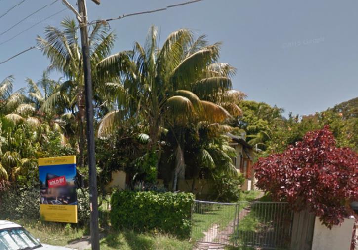
Figure 1: Subject Site
Section 96 Assessment
Under the provisions of Section 96 of the Environmental Planning and Assessment Act, 1979, as amended, Council may only agree to a modification of an existing Development Consent if the following criteria has been complied with:-
Substantially the Same Development
Council may only approve an application under Section 96(2) of the Environmental Planning and Assessment Act 1979 if “it is satisfied that the development to which the consent as modified relates is substantially the same development as the development for which consent was originally granted and before that consent as originally granted was modified (if at all) under this section”.
The proposed modifications will not result in a change to the essence of the original development, as changes are largely internal and involve ancillary landscape changes..
Submissions
The owners of adjoining and likely affected neighbouring properties were notified of the proposed development in accordance with the Randwick Comprehensive DCP 2013. The following submission was received as a result of the notification process:
5/55-57 Arden Street, Clovelly
|
Objection |
Comment |
|
Concerns regarding the location of the proposed pool and the potential for acoustic and visual privacy impacts to result from the proposed ‘plunge pool’. |
The proposed ‘plunge pool’ is located in the north-western corner of the subject site, immediately adjacent to the pool located at the rear of 12 Burnie Street. The pool location is therefore appropriately located.
Standard acoustic conditions have been recommended to ensure that the proposed ‘plunge pool’ and associated equipment does not result in adverse acoustic impacts on the adjoining properties.
The objector’s property will not be overlooked by the pool area, and will be sufficiently screened by the existing dividing fence. The proposed pool does not require in the removal of any of the large existing trees along the rear boundary (these will remain). It is considered that the proposed pool subject to conditions will not result in any significant adverse impacts on the adjoining properties amenity. |
Key Issues
· Deep Soil Landscaping
Section 2.2.2 of the Part C2 of the RDCP 2013 states that the subject site must provide a minimum of 25% of the site area should incorporate deep soil areas sufficient in size and dimensions to accommodate trees and significant planting.
The subject section 96 application seeks to delete condition 2(a) of the original development consent which read:
2(a) The swimming pool at the rear of the westernmost dwelling is deleted
from the consent.
The subject section 96 applications seeks approval for a ‘plunge pool’ in the north-western corner of the subject site, the dimensions of the pool are 1.87m x 3.72m (6.96m²). The ‘plunge pool’ has been reduced in size from what was originally proposed as part of DA/883/2014 and soft landscaping has been provided surrounding the ‘plunge pool’.
It is acknowledged that the proposed pool will still result in a small reduction in deep soil area available on site. It will not however result in the removal of any trees or significant planting and will only replace a small section of approved grassed area in the north-western corner of the site.
The objectives of the RDCP 2013 in regards to landscaped open space and deep soil area are:
· To provide landscaped open space of sufficient size to enable the space to be used for recreational activities, or be capable of growing substantial vegetation.
· To reduce impermeable surface cover including hard paving.
· To improve stormwater quality and reduce quantity.
· To improve the amenity of open space with landscaped design.
The subject site includes the following areas of deep soil in its calculations:
· The site includes permeable pavers over deep soil along the southern boundary in its calculations. This deep soil area has a similar impact as loose gravel, It does not allow for substantial planting but does allow for storm water infiltration and reduced overland flow on site,
· A front and rear garden area which accommodates significant planting and trees.
The proposal results in a deep soil area on site of 29% of which approximately 17% is capable of accommodating significant planting and trees (See figure 2 below).
Figure 2: Deep Soil Area shaded dark grey
It is considered that the section 96 application whilst resulting in a small decrease in deep soil area from what was approved, will still provide sufficient deep soil area capable of growing substantial vegetation on site, allowing for storm water infiltration and reducing overland flow.
The proposal meets the relevant objectives in the RDCP 2013 relating to deep soil permeable surfaces on site and will not result in any adverse impacts on the adjoining properties.
· Acoustic Privacy
The proposed ‘plunge pool’ and associated equipment is located in the north-western corner of the subject site, immediately adjacent to the pool located at the rear of 12 Burnie Street (site to the north). It is considered that the pool is in a suitable location and will not result in any unreasonable acoustic impacts, notwithstanding this, to ensure that the pool and associated equipment does not result in any ‘offensive noise’ adversely affecting the acoustic privacy of the surrounding properties, suitable conditions have been recommended as part of this report.
The proposal subject to conditions recommended will not result in any adverse acoustic impacts on the adjoining properties. The proposed pool location is consistent with pools in the surrounding area and is considered to meet the relevant objectives and controls in the RDCP 2013.
Relationship to City Plan
The relationship with the City Plan is as follows:
Outcome 4: Excellence in urban design and development.
Direction 4a: Improved design and sustainability across all development.
Financial impact statement
There is no direct financial impact for this matter.
Conclusion
Overall, the essence of the application is not changing and it complies with the majority of the RDCP 2013 controls. The proposal modifications, are suitable for the site, they satisfy the relevant assessment criteria and will not result in any significant adverse impacts upon either the amenity of the adjoining premises or the character of the locality.
The application is, therefore, recommended for approval subject to the attached conditions of consent.
|
That Council, as the consent authority, grants development consent under Section 96 of the Environmental Planning and Assessment Act 1979, as amended, to Development Application No. DA/883/2014/A for alterations to the ground floor layout, reduction of the unit 1 terrace, addition of external stairs, increase size of planter on northern boundary, new plunge pool in north-west corner of site with landscaping and planting, at No. 2 Beach Street Clovelly, in the following manner:
· Amend Condition No. 1 to read: 1. The development must be implemented substantially in accordance with the plans and supporting documentation listed below and endorsed with Council’s approved stamp, except where amended by Council in red and/or by other conditions of this consent:
As amended by the Section 96 “A” plans and supporting documentation listed below:
only in so far as they relate to the modifications highlighted on the Section 96 plans and detailed in the Section 96 application, except as may be amended by the following conditions and as may be shown in red on the attached plans.
· Delete condition 2 (a).
· Add Condition 89 to read:
Swimming Pool Safety 89. Swimming pools are to be designed and installed in accordance with the relevant requirements of the Building Code of Australia and be provided with childproof fences and self-locking gates, in accordance with the Swimming Pools Act 1992 and the Swimming Pools Regulation 2008.
The swimming pool is to be surrounded by a child-resistant barrier (e.g. fence), that separates the pool from any residential building (as defined in the Swimming Pools Act 1992) that is situated on the premises and from any place (whether public or private) adjoining the premises; and that is designed, constructed and installed in accordance with Australian Standard AS 1926.1 – 2012 (Swimming Pool Safety Part 1 - Safety Barriers for Swimming Pools).
Gates to pool area must be self-closing and latching at all times and, the gate is required to open outwards from the pool area and prevent a small child opening the gate or door when the gate or door is closed.
Temporary pool safety fencing is to be provided pending the completion of all building work and the pool must not be filled until a fencing inspection has been carried out and approved by the principal certifying authority.
A ‘warning notice’ must be erected in a prominent position in the immediate vicinity of the swimming pool, in accordance with the provisions of the Swimming Pools Regulation 2008, detailing pool safety requirements, resuscitation techniques and the importance of the supervision of children at all times.
Note: This development consent does not approve the design and location of swimming pool fencing and other swimming pool safety barriers. Swimming pool fencing and other safety barriers are required to comply with the Swimming Pools Act 1992, Swimming Pools Regulation 2008 and relevant Standards. Details of compliance are required to be incorporated into the plans and specifications for a Construction Certificate, to the satisfaction of the Certifying Authority.
· Add Condition 90 to read:
Swimming Pool & Spa Pool Requirements 90. Swimming pools (and spa pools) are to be designed, installed and operated in accordance with the following general requirements:
a) Backwash of the pool filter and other discharge of water is to be drained to the sewer in accordance with the requirements of the Sydney Water Corporation; and
b) All pool overflow water is to be drained away from the building and adjoining premises, so as not to result in a nuisance or damage to premises; and
c) Water recirculation and filtrations systems are required to comply with AS 1926.3 – 2010: Swimming Pool Safety – Water Recirculation and Filtration Systems; and
d) Pool plant and equipment is to be enclosed in a sound absorbing enclosure or installed within a building, to minimise noise emissions and possible nuisance to nearby residents.
· Add Condition 91 to read:
Notification of Swimming Pools & Spa Pools 91. The owner of the premises must ‘register’ the swimming pool on the NSW Swimming Pool Register, in accordance with the Swimming Pools Amendment Act 2012.
The Swimming Pool Register is administered by the NSW Government, Department of Premier & Cabinet, Division of Local Government and registration on the Swimming Pool Register may be made on-line via their website www.swimmingpoolregister.nsw.gov.au.
Registration must be made prior to the issue of an Occupation Certificate for the pool and a copy of the NSW Swimming Pool Certificate of Registration must be forwarded to the Principal Certifying Authority and Council accordingly.
· Add Condition 92 to read:
Plant & Equipment 92. The operation of all plant and equipment on the premises shall not give rise to an ‘offensive noise’ as defined in the Protection of the Environment Operations Act 1997 and Regulations.
In this regard, the operation of the plant and equipment shall not give rise to an LAeq, 15 min sound pressure level at any affected premises that exceeds the background LA90, 15 min noise level, measured in the absence of the noise source/s under consideration by more than 5dB(A) in accordance with relevant NSW Office of Environment & Heritage (EPA) Noise Control Guidelines.
· Add Condition 93 to read:
Swimming/Spa Pools 93. The pool plant and equipment shall not be operated during the following hours if the noise emitted can be heard within a habitable room in any other residential premises, or, as otherwise specified in relevant Noise Control Regulations:
· before 8.00am or after 8.00pm on any Sunday or public holiday; or · before 7.00am or after 8.00pm on any other day.
|
Nil

Development Application Report No. D34/16
Subject: 2 Beach Street, Clovelly (DA/883/2014/B)
Folder No: DA/883/2014/B
Author: Christopher Gorton, Assessment Officer
Proposal: Section 96 modification of the approved development by addition of attic level to each dwelling, containing a bedroom and a bathroom, with alterations to the roof design and alterations to driveway gradient
Ward: North Ward
Applicant: Brenchley Architects
Owner: Mr W C Scott & Mrs P Scott
Summary
Recommendation: Refusal
|
|
|
|
Subject Site |
|
|
|
|
|
|
|
|
|
|
|
|
|
|
Submissions received
|
|
|
Ù North
|
|
|
Locality Plan |
Development Application Executive summary report
This application is referred to the Planning Committee for consideration as the original application was determined by Council.
1. Details of current approval
On 14 July 2015, approval was granted at a Planning Committee meeting for the demolition of an existing dwelling house and construction of a multi unit dwelling house development, comprising of 5 x 2 storey townhouses and basement parking, associated site and landscape works.
There is a section 96 ‘A’ application that has not yet been determined and is subject to consideration at a Planning Committee Meeting on the 12 April, 2016. The Section 96 ‘A’ application sought approval for the following changes:
· Minor changes to the internal layout of the ground floor pantry and adjacent w/c of units 1, 2, 3, 4 and 5;
· Planter boxes have been proposed along the northern side wall for the whole boundary from east to west (as per condition 2h of the development consent);
· The front terrace at ground floor level has been setback 850mm to align with the basement level (as per condition 2g of the development consent);
· Addition of stairs from the front terrace to unit 1 at ground floor level to the landscaped area fronting Beach Street;
· Deletion of condition 2a and installation of a ‘plunge pool’ and associated landscaping in the north-western corner of the site.
2. Proposal
The section 96 ‘B’ application seeks to modify the original consent as follows:
· Minor Changes to the existing driveway in accordance with Condition 2b of the development consent;
· Minor changes to the internal layout of the ground floor pantry and adjacent w/c of units 1, 2, 3, 4 and 5;
· New pop-up dormer windows on the northern elevation; and
· New attic level incorporated within the 5 pop-up dormer windows. Attic level includes 1 bedroom and 1 bathroom with associated storage for each dwelling.
The application is also the subject of a deemed refusal appeal to the Land & Environment Court.
3. Site
The subject site is known as 2 Beach Street, Clovelly and formally described as Lot 22 in DP 5397. The site is a regular shaped allotment with a 15.24 frontage to Beach Street and a total site area of 780.8m2.
The land has a fall from west to east of approximately 2m over the depth of the site representing a grade of approximately 4% and a slight cross fall from south to north.
The site is currently occupied by a single storey dwelling house and rear outbuilding which will be demolished.
To the north the site is adjoined by the rear yard areas of dwelling houses fronting Burnie Street and to the south and west multi-dwelling housing developments.
The locality comprises a mix of residential development including detached and semi-detached dwellings, multi-unit developments, and some residential flat buildings.
The subject site is also within close proximity to the following:
· 800m of several educational establishments including Clovelly Public School, St Anthony’s School, University of NSW (Cliffbrook Campus) and St Catherine’s School;
· 120m north of Clovelly Road and 50m east of Arden Street which have regular bus services connecting this area to the CBD and other eastern Sydney suburbs;
· 420m north west of Gordon’s Bay and 580m north west of Clovelly Beach;
· 150m north east of the Clovelly Road shops and Burnie Park 50m to the north.
Figure 1: Subject Site
4. Section 96 Assessment
Section 96(2) of the Environmental Planning and Assessment Act 1979, states that a consent authority may, on application being made by the applicant or any other person entitled to act on a consent granted by the consent authority and subject to and in accordance with the regulations, modify the consent if:
(a) it is satisfied that the development to which the consent as modified relates is substantially the same development as the development for which consent was originally granted and before that consent as originally granted was modified (if at all), and
(b) it has consulted with the relevant Minister, public authority or approval body (within the meaning of Division 5) in respect of a condition imposed as a requirement of a concurrence to the consent or in accordance with the general terms of an approval proposed to be granted by the approval body and that Minister, authority or body has not, within 21 days after being consulted, objected to the modification of that consent, and
(c) it has notified the application in accordance with:
(i) the regulations, if the regulations so require, or
(ii) a development control plan, if the consent authority is a council that has made a development control plan that requires the notification or advertising of applications for modification of a development consent, and
(d) it has considered any submissions made concerning the proposed modification within the period prescribed by the regulations or provided by the development control plan, as the case may be.
The proposal will still result in a development that is substantially the same as that for which the consent was granted The proposed modifications involve internal changes and reconfiguration; an increase in the number of bedrooms from 3 per dwelling to 4 per dwelling, with the additional bedroom being accommodated at the proposed attic level; and 5 new dormer windows provided for each bedroom on the northern elevation. In the context of the overall scope of the development the proposed modifications collectively do not alter the nature or essence of the approved building for which consent was originally granted and as such can be assessed as a Section 96 application. Whilst a new attic level is proposed, the approved number of townhouses remain the same and the increased size of the building will still be within the ambit of a S96 application given that the increased volume arises from dormes to the approved roof.
5. Submissions
The owners of adjoining and likely affected neighbouring properties were notified of the proposed development in accordance with the Randwick Comprehensive DCP 2013. The following submissions were received as a result of the notification process:
· 6 Beach Street, Clovelly
· 23 Beach Street, Clovelly
· 18 Burnie Street, Clovelly
· 6a Beach Street, Clovelly
· 16 Burnie Street, Clovelly
· 19 Beach Street, Clovelly
· 8a Beach Street, Clovelly
· 28 Burnie Street, Clovelly
· 5 Beach Street, Clovelly
· 7 Beach Street, Clovelly
· 1a Burnie Street, Clovelly
· 5/55-57 Arden Street, Clovelly
· 4 Beach Street, Clovelly
· 3 Beach Street Clovelly
· 22 Burnie Street, Clovelly
· 11 Beach Street, Clovelly
· 14 Burnie Street, Clovelly
The issues raised in the above objections are as follows:
· The proposal does not comply with the RLEP 2012 control for maximum permissible F.S.R on site:
Planners Comment
RLEP 2012 adopts an FSR of 0.75:1 to the subject site. The subject application proposes to increase the approved floor space of 0.74:1, to 0.88:1. An objection under Clause 4.6 of RLEP 2012 is not necessary in respect of a Section 96 application. See discussion in key issues section below.
· The proposal does not comply with the RLEP 2012 control for maximum building height permissible on site:
Planners Comment
RLEP 2012 adopts a maximum building height of 9.5m to the subject site. The subject application proposes to increase the approved maximum building height of 8.4m, to approximately 9.85m. An objection under Clause 4.6 of RLEP 2012 is not necessary in respect of a Section 96 application. See discussion in key issues section below.
· The proposal does not comply with the RDCP 2013 maximum external wall height control:
Planners Comment
It is acknowledged that the proposed dormer windows result in an increase in external wall height. The proposal does not comply with the RDCP 2013 controls for external wall height; see discussion in key issues section below.
· The proposal does not provide any additional parking on site to accommodate the increased occupancy of the development:
Planners Comment
The proposal complies with the relevant parking rates outlined under section B7 of the RDCP 2013. The parking rates do not change for a 3 bedroom as opposed to a 4 bedroom dwelling.
· The property has already been advertised and sold as 4 bedroom dwellings:
Planners Comment
What a property is sold for or advertised as, has no bearing on the assessment of the application, the proposal has been assessed against the relevant controls and objectives of the RDCP 2013 and RLEP 2012 as well as the relevant heads of consideration of SEPP 65.
· The proposed amendments are not considered to be substantially the same and as such the application cannot be assessed as a Section 96 application:
Planners Comment
The proposed modifications involve an increase in the size of the building envelope. However, in the context of the overall scope of the development the proposed modifications are considered to result in a development that remains substantially the same as the development for which consent was originally granted and as such can be assessed as a Section 96 modification.
· The proposed amendments result in SEPP 65 being applicable to the development and as such comments from the DRP area required:
Planners Comment
The subject section 96 application is subject to SEPP 65 and was referred to Council’s Design Review Panel (DRP) for comment. Comments were received from the DRP and an assessment against SEPP 65 and the Apartment Design Guidelines (ADG) has been carried out. See discussion in key issues section below.
· Insufficient information provided on Council’s DA Tracking website:
Planners Comment
A full working folder is kept at council’s main office which is accessible to the public throughout the assessment period. Council’s DA Tracking website provided the following information: a copy of the notification plans, shadow diagrams and Statement of Environmental Effects, which satisfies the requirements for public exhibition.
· Objections raised to the non-compliance with the ceiling heights and internal amenity of the attic addition:
Planners Comment
It is acknowledged that the proposal does not comply with the ADG requirements for ceiling heights, see discussion in key issues section below.
· Inaccurate information provided with regards to F.S.R calculations:
Planners Comment
Council has calculated the F.S.R of the amended proposal and it is acknowledged that the F.S.R stated in the Statement of Environmental Effects is incorrect as it does not include the wardrobes etc. The F.S.R of the amended proposal has been calculated in accordance with the definition of gross floor area outlined in the RLEP 2012. The F.S.R is 0.88:1.
· Proposal does not comply with the RDCP 2013 requirements for habitable roof space:
Planners Comment
It is acknowledged that the proposal does not comply with all the relevant controls and objectives outlined in the RDCP 2013 for habitable roof space, see discussion in key issues section below.
· Queries relating to the dividing fence between adjoining properties as no details have been provided:
Planners Comment
Dividing fences are subject to the provisions of the Dividing fences Act 1991. The subject section 96 application does not propose any changes to the dividing fences on the subject site.
· Objection to potential overshadowing impacts on the adjoining properties:
Planners Comment
The proposal results in a negligible increase in overshadowing to the adjoining properties. The Dormer Windows are located to the north of the development and as such the shadows cast by the existing approved development will not be increased between the hours of 10am and 2pm on June 21st. The proposal remains consistent with the approved development with regards to overshadowing and is considered to meet the relevant objectives and controls in the RDCP 2013 and ADG.
· Visual Privacy concerns have been raised by residents on Burnie Street:
Planners Comment
It is acknowledged that the proposed Dormer Windows to the northern elevation will have the potential to result in privacy impacts on the properties along the southern side of Burnie Street. See Key Issues section in this report for further discussion.
· Concerns regarding potential acoustic impacts
Planners Comment
The proposed development is permissible within the R3 medium density zone, the proposed dormer windows will not result in any additional acoustic impacts on the adjoining properties. The proposal is considered to meet the relevant objectives and controls with regards to Acoustic Privacy in the RDCP 2013.
· Objection to the proposal as it is out of scale, out of character and an overdevelopment of the site
Planners Comment
It is considered that the proposal is of a scale that is incompatible with the character of the surrounding streetscape. It is considered that the proposal does not comply with the relevant objectives of the R3 medium density zone, the proposal will result in adverse impacts on the amenity of surrounding residents and does not recognise the desirable elements of the existing streetscape and built form nor does it contribute to the desired future character of the area.
The proposal is non-compliant with several RDCP 2013 controls (external wall height, visual privacy, internal amenity) as well as RLEP 2012 objectives (F.S.R and Building Height), all of which assist in controlling the maximum building envelope of a development. It is considered that the proposal will result in adverse impacts on the streetscape and surrounding residents, and as such has been recommended for refusal.
6. Key Issues
Built Form
· Floor Space Ratio (FSR)
RLEP 2012 adopts an FSR of 0.75:1 to the subject site. The subject application proposes to increase the approved floor space of 0.74:1, to 0.88:1. An objection under Clause 4.6 of RLEP 2012 is not necessary in respect of Section 96 applications.
The additional floor space proposed (112.65m²) is located at attic level and results in a 17.3% non-compliance with the F.S.R control. This additional floor area will be clearly visible from the streetscape and adjoining properties as it is contained within 5 large dormer windows located along the northern elevation. The northern elevation adjoins the rear private open space of Nos. 12, 14, 16, 18 and 20 Burnie Street.
The objectives of the Floor Space Ratio control provide the framework for assessment of the proposal especially as to whether it achieves the key outcomes that a development is expected to achieve in relation to this control:
§ To ensure that the size and scale of development is compatible with the desired future character of the locality;
The additional floor area located at attic level directly results in the proposals non-compliance with Clause 4.4 of the RLEP 2012. This additional floor space contained within the proposed dormer windows will be clearly visible and prominent from the neighbouring properties and the streetscape. It will result in a development which is out of scale and character with the desired future of the locality. The 5 proposed dormer windows will be visually prominent on site and dominate the approved roof form when viewed from the neighbouring properties.
§ To ensure that development does not adversely impact on the amenity of adjoining and neighbouring land in terms of visual bulk, loss of privacy, overshadowing and views.
The additional floor area which directly results in the proposals non-compliance with Clause 4.4 of the RLEP 2012 is located at attic level and will be visible via 5 large dormer windows which will protrude from the northern elevation. These dormer windows will adversely affect the adjoining properties having regards to visual bulk and loss of privacy.
Each dormer window includes 4 large fixed glass panes which will have the potential to overlook the rear primary private open space of Nos. 12, 14, 16, 18 and 20 Burnie Street. The dormer windows as viewed from the rear private open space areas of the aforementioned properties will be dominant elements resulting in increased perceivable mass and bulk of the approved development. In addition the dormer windows result in additional non-compliance with the RLEP 2012 maximum building height control and the RDCP 2013 external wall height control.
The subject section 96 application does not meet the relevant objectives of Clause 4.4 of the RLEP 2012 and results in a 17.3% non-compliance with the numerical floor space control. The additional floor area will adversely affect the adjoining properties amenity having regards to increased visual bulk and privacy impacts and will adversely affect the streetscape character.
· Maximum Building Height & External Wall Height
RLEP 2012 adopts a maximum building height of 9.5m to the subject site. The subject application proposes to increase the approved maximum building height to approximately 9.85m. An objection under Clause 4.6 of RLEP 2012 is not necessary in respect of a Section 96 application.
The RDCP 2013 states that the subject site has a maximum applicable external wall height of 8m. As the proposed dormer windows extend more than 2m from the roof plane, the external wall height is measured to the underside of the eaves. As such the subject section 96 results in an external wall height of 9.5m, which does not comply with the RDCP 2013 controls.
The maximum building height and external wall height controls work together to assist in controlling the size and scale of a development. The combination of non-compliance with both the building height and external wall height controls outlined in the RLEP 2012 and RDCP 2013 compounds the adverse impacts on the streetscape and adjoining properties. The resultant development will appear as visually bulky and dominating within its surrounds and is not compatible with the desired future character of the locality.
The non-compliance with the aforementioned standards adversely impacts the amenity of the surrounding properties in terms of visual bulk and privacy. A development that complied with both the maximum height and external wall height control would provide for a building that is manifestly smaller than that of the amended proposal. The section 96 application does not meet the relevant objectives and controls outlined in the RLEP 2012 and RDCP 2013.
· Habitable Roof Space & Roof Design
The subject section 96 application does not comply with the relevant objectives and controls of Clauses; 4.2 – Roof Design; and 4.3 – Habitable Roof Space outlined in the RDCP 2013.
Clause 4.2 of the RDCP 2013 states:
· To ensure roof design integrates with the overall form, proportions and facade composition of the building.
· Design the roof form, in terms of massing, pitch, profile and silhouette to relate to the three dimensional form (size and scale) and facade composition of the building
It is considered that the 5 proposed dormer windows are dominant features within the approved pitched roof form and will result in significant additional mass when viewed from the neighbouring properties. The proposed dormer windows will adversely affect the adjoining properties to the north with regards to visual bulk. The size of the dormer windows do not respond or integrate with the approved roof and do not meet the relevant objectives and controls of Clause 4.2 of the RDCP 2013.
Clause 4.3 of the RDCP 2013 states:
· To promote high amenity apartment design with flexible layout and good natural ventilation.
· To provide opportunities for creating interesting roof forms that contribute to the streetscape and neighbourhood character.
The proposed habitable roof space does not result in a high amenity apartment (see amenity discussion below), nor does it provide for an interesting roof form that contributes to the neighbourhood character. The approved development (DA/883/2014) complied with both the F.S.R and Building height controls in the RLEP 2012 and RDCP 2013, the habitable roof space directly results in non-compliances in both these areas. In addition the proposed habitable roof space does not comply with the RDCP 2013 or ADG requirements for floor to ceiling heights.
It is considered that the proposed habitable roof space has not been provided with sufficient natural ventilation, nor have the windows been designed as an integrated element within the roof form. The dormer windows to the habitable roof space are dominating and appear as piecemeal additions to the development. The proposal does not meet the relevant objectives or controls of the RDCP 2013.
Visual Privacy
The proposed dormer windows on the northern elevation will have the potential to overlook the primary private open space of Nos. 12, 14, 16, 18 and 20 Burnie Street. Potential overlooking from the approved first floor level was mitigated through privacy measures that were integrated into the overall design of the development.
The 5 dormer windows are located to bedrooms and have maximum 1.4m high sill heights, they will all directly result in downward overlooking of primary private open space. Privacy measures such as fixed obscure glazing or raised sill heights could be implemented on these windows, however this would result in further amenity impacts of the attic level (See discussion on amenity below).
The proposal does not comply with the relevant controls and objectives of the RDCP 2013 with relation to privacy. The subject section 96 application will adversely affect the visual privacy of the northern adjoining properties.
Amenity
· RDCP 2013
The subject section 96 application does not comply with the relevant objectives and controls of Clauses; 4.7 – Apartment Layout; and 5.2 – Natural ventilation and energy efficiency outlined in the RDCP 2013.
The proposed attic level has been provided with fixed windows to the northern elevation (Bedroom) and 2 ventilated skylights, 1 to the bathroom and 1 to the stair landing. It is considered that the proposal does not provide sufficient internal amenity in terms of natural ventilation for the attic level.
Clause 4.7 of the RDCP 2013 states that:
§ To ensure apartment layouts provide high standard of living amenity in terms of access to sunlight and natural ventilation, visual and acoustic privacy, open space provision and accommodate a range of domestic activities.
§ Providing at least 1 openable window (excluding skylight) opening to outdoor areas for all habitable rooms and limiting the use of borrowed light and ventilation.
Clause 5.2 of the RDCP 2013 states that:
§ To ensure that dwellings are designed to provide all habitable rooms with direct access to fresh air and assist in promoting thermal comfort for occupants.
§ All habitable rooms (that is living rooms, dining rooms, rumpus rooms, kitchens and bedrooms) must incorporate windows opening to outdoor areas. The sole reliance on skylight or clerestory windows for natural lighting and ventilation is not acceptable.
§ All new residential units must be designed to provide natural ventilation to all habitable rooms. Mechanical ventilation must not be the sole means of ventilation to habitable rooms
The subject section 96 application does not meet the aforementioned objectives and controls outlined in the RDCP 2013. The proposal does not provide sufficient internal amenity for the occupants of the dwellings in terms of natural ventilation; it is considered that the attic level will not provide good amenity and will compromise the amenity of any occupants. It should be noted that the quality of the space would be further degraded if windows were required to be fixed and obscured for privacy mitigation measures.
· Apartment Design Guide
4C-1: Ceiling Heights
The proposal does not meet the design criteria outlined in the Apartment Design Guide under objective 4C-1, which states:
Measured from finished floor level to finished ceiling level, minimum ceiling heights are:
|
Minimum Ceiling height for apartment and mixed use buildings |
|
|
Habitable rooms |
2.7m |
|
Non-habitable |
2.4m |
|
For 2 storey apartments |
2.7m for main living area floor; 2.4m for second floor where its area does not exceed 50% of the apartment area |
|
Attic spaces |
1.8m at edge of room with a 30 degree minimum ceiling slope |
|
If located in mixed used areas |
3.3m for ground and first floor to promote future flexibility of use. |
These minimums do not preclude higher ceilings if desired.
The proposed section 96 application proposes an attic level which has a minimum 1.8m ceiling height and a maximum 2.8m ceiling height. The proposed attic ceiling has an approximate 16 degree slope, which does not meet the minimum requirements of the ADG. In addition to the above the inclusion of the attic space results in a portion of the master bedrooms having a 2.4m ceiling height and a portion of the bedrooms 1 and 2 having a 2.1m ceiling height.
It is considered that the non-compliance with the ADG ceiling height requirements reduces the internal amenity of both the attic space and the first floor level bedrooms of all dwellings.
The proposal does not comply with the relevant objectives and design criteria of the Apartment Design Guide.
Relationship to City Plan
The relationship with the City Plan is as follows:
Outcome 4: Excellence in urban design and development.
Direction 4a: Improved design and sustainability across all development.
Financial impact statement
There is no direct financial impact for this matter.
Conclusion
The size and scale the proposed development that would result from the modified scheme is considered to be unsuitable for the site and is inconsistent with the desired future character of the locality. The proposed density and height will also give rise to detrimental impacts to surrounding residential properties in terms of visual bulk and scale, and privacy. In addition the proposed attic level does not provide sufficient internal amenity for the occupants. As such the proposed development does not satisfy the matters for consideration under Section 79C of the Environmental Planning and Assessment Act 1979, as amended.
Accordingly, the application is recommended for refusal
|
That Council, as the consent authority, refuses development consent under Section 96 of the Environmental Planning and Assessment Act 1979, as amended, to Development Application No. DA/883/2014/B by way of addition of an attic to each dwelling containing a bedroom and a bathroom with alterations to the roof design and alterations to the driveway gradient, at No. 2 Beach Street, Clovelly for the following reasons:
1. The proposal does not satisfy the objectives of the R3 Medium Density zone related to recognising the desirable elements of the existing streetscape and built form, contributing to the desired future character of the area, and protecting the amenity of surrounding residents, which are specified in the Randwick Local Environmental Plan 2012.
2. The proposal exceeds the maximum building height of 9.5m specified in Clause 4.3 of Randwick Local Environmental Plan 2012 and the resultant built form will be of a size and scale that is incompatible with the desired future character of the locality and adversely impacts the amenity of adjoining residents in terms of visual bulk and loss of privacy.
3. The proposal exceeds the maximum F.S.R of 0.75:1 specified in Clause 4.4 of Randwick Local Environmental Plan 2012 and the resultant built form will be of a size and scale that is incompatible with the desired future character of the locality and adversely impacts the amenity of adjoining residents in terms of visual bulk and loss of privacy.
4. The proposal does not satisfy the relevant controls and objectives in relation to roof design contained within Randwick DCP 2013 Part C2, Clause 4.2.
5. The proposal does not satisfy the relevant controls and objectives in relation to habitable roof space contained within Randwick DCP 2013 Part C2, Clause 4.3.
6. The proposal does not satisfy the relevant controls and objectives in relation to external wall height contained within Randwick DCP 2013 Part C2, Clause 4.4.
7. The proposal does not satisfy the relevant controls and objectives in relation to apartment layout contained within Randwick DCP 2013 Part C2, Clause 4.7.
8. The proposal does not satisfy the relevant controls and objectives in relation to natural ventilation and energy efficiency contained within Randwick DCP 2013 Part C2, Clause 5.2.
9. The proposal does not satisfy the relevant controls and objectives in relation to Visual Privacy contained within Randwick DCP 2013 Part C2, Clause 5.3.
10. The proposal does not satisfy the relevant heads of consideration specified in Schedule 1 of State Environmental Planning Policy No 65 –Design Quality of Residential Flat Buildings.
11. The proposal does not satisfy the design criteria and design guidance set-out in Part 4C Ceiling Heights of the Apartment Design Guide as per SEPP 65.
12. The proposal fails to satisfy the relevant considerations under Section 79C(1) (b),(c) and (e) Environmental Planning and Assessment Act 1979 for natural and built environmental impacts, suitability of the site, and the public interest.
|
|
DA Compliance Report - 2 Beach Street, Clovelly |
Included under separate cover |
Miscellaneous Report No. M2/16
Subject: Newmarket draft Development Control Plan- Post Exhibition - open space and affordable housing provisions
Folder No: F2015/00324
Author: Stella Agagiotis, Co-ordinator, Strategic Planning
Introduction
Proposed amendments to Randwick Development Control Plan 2013 (DCP) Chapter E5 – Newmarket Green (Inglis Site bounded by Barker, Jane, Young and Botany St) were placed on public exhibition between 29 September to 27 October 2015. Submissions were invited through a dedicated web page on ‘Yoursay Randwick’. The drafting changes are aimed at clarifying and strengthening affordable housing and public open space provisions contained in this site specific DCP chapter of Council’s DCP.
There were 29 submissions made in response to the exhibited changes, with the majority supporting the introduction of a new clause addressing the affordable housing requirements for the site and more specific design controls for the configuration of the proposed area to be set aside for public open space (an area of 5,000m2). The draft amendments are highlighted in yellow in Attachment 1.
This report recommends that Council proceed with the DCP modifications as exhibited in accordance with provisions under the Environmental Planning and Assessment Act, 1979 (‘the Act’). If Council adopts the changes, they will take effect from the day they are published in the local newspaper.
Background
The LEP for the Newmarket Site took effect from 2 April 2015 and the DCP (which contains the more detailed planning controls for future development) was adopted by the Secretary of the Department of Planning and Environment on 30 March 2015. The LEP changed the zoning, heights and floor space ratio applicable to the land. As a result of the LEP, the land is currently zoned part R1 General Residential and Part B1 Neighbourhood Business, permissible maximum heights range from 25m to 10m across the site and the permissible FSR across the site is 1.3:1.
The new site-specific controls for future development on the site have been incorporated into the Council’s principle DCP as a separate chapter (Chapter E5). In summary, these provisions include an overall vision and design principles, specific controls for each precinct, management of heritage items, design of the open space and the public domain (including roads and footpaths), built form/design controls, landscaping, heritage and car parking.
The current owner of the site CBus Property lodged a stage 1 (concept) development application on 17 February 2016. The DA is currently being assessed by Council officers.
The proposed amendments to the DCP are consistent with legal advice obtained by Council which suggested strengthening provisions relating to open space and affordable housing.
Draft DCP provisions exhibited
Public Open Space provisions
Given that a separate open space zone has not been included on the site, the LEP instrument specifies that no development can be approved on the land until the consent authority is satisfied that at least 5,000m2 of land is available for public open space. The proposed DCP amendment that was exhibited for public comment supplements this LEP clause and requires that:
· The area of proposed open space is to be in one single allotment with minimum dimensions of 66m x 76m.
· The configuration, location and right of public access to the public open space is to be appropriate for this use
· The public open space be designed with at least 2 street frontages to enable good public access and opportunities for passive surveillance.
Affordable Housing provisions
Given the site’s strategic location near the hospitals complex and University, the site offers a unique opportunity to provide key worker housing in the area and to make a positive contribution to local housing needs.
The Planning Proposal placed on public exhibition included a draft provision requiring 5% of the residential floor space on the site to be provided as affordable housing. The NSW Government Architect’s Site Review prepared for Council in October 2011 supported the provision of affordable housing on the site. The JRPP in its endorsement of the Planning Proposal for public exhibition on 4 December 2012, which was subject to:
“…(b) a minimum of 5% of the net residential floor space being affordable housing;”
Council’s submission to the JRPP on the exhibited Planning Proposal (May 2013), also requested that the provision of affordable housing on the site be supported.
Whilst the objectives and development principles in the Newmarket DCP address affordable housing, the specific affordable housing clause was removed by the Department of Planning and Environment prior to the final DCP being approved. The delivery of affordable housing relies on an interpretation of the objectives and development principles of Chapter E5 which state that future development shall provide for “housing types that meet the needs of key workers and students, including affordable housing”. This provision can only come into effect through a Voluntary Planning Agreement (VPA).
The lack of certainty and the absence of a planning mechanism to ensure the provision of affordable housing on this site were raised in letters to the Secretary of the Department of Planning and to the Minister in 2015. These issues and the need for greater clarity on the configuration of the public open space were discussed in a subsequent meeting between the Minister, Mayor, and Director of City Planning in April 2015. At this meeting, the Minister acknowledged the need to reinstate a provision to ensure the delivery of affordable housing on the site given its strategic location adjacent to the Randwick Health and Education Precinct.
Overview of Submissions
Twenty nine submissions were received from the community, including key stakeholders: NSW Department of Family and Community Services, Shelter NSW, CBus Property (current owner of the site) and the previous owner of the site.
Summary of Submissions
Submissions in support 24
Submissions against (or partly against) 5
Total: 29
Submissions relating to Open Space
Submissions received during the public exhibition period were generally in support of the proposed amendments to the design of the public open space that specify minimum dimensions and street frontages. Some submissions suggested increasing the amount of open space to be dedicated. One submission suggested that landscaping of the public open space should be consistent with the heritage values of the area and that responsibility for its on-going maintenance and upkeep be clarified, which is a matter for consideration at the DA stage.
Submission by owner of site relating to open space
The current owner of the site (CBus Property) has made the following points in relation to the proposed open space clauses:
· The proposed dimensions unnecessarily constrains master planning of the site including design of the road alignments. Alternative solutions to the road layout to improve safety are being considered.
· Development on the site will ensure that the overall vision, objectives and principals contained in the DCP are met and therefore flexibility should be applied rather than rigid dimensions
· A minimum of 5,000m2 of contiguous open space will be provided on the site. The open space will be of high quality, regular in shape and usable.
Council officer’s response
The configuration of the open space was specifically identified in the DCP (concept site layout) which was made by the Secretary of the Department in March 2015. One mechanism for the dedication of the proposed public open space area to Council would be through a Voluntary Planning Agreement (VPA). Any future VPA must be offered by an owner/applicant. The terms of the VPA would need to be endorsed by Council and required to be publicly exhibited in accordance with the EPA Act prior to or at the same time as lodgement of a future development application.
The design and embellishment of the public open space will be considered during the assessment of a future development application for this part of the site (which will be exhibited for public comment) and will be guided by the provisions of the DCP - specifically clauses 3.4 and 3.5. The stage 1 DA for the site shows an area of 5004m2 of public open space with three street frontages, generally square in shape (splayed on one side next to Newmarket House) and dimensions of 75m and 45m on one side and 72m and 44m on the other side. This is generally consistent with the minimum draft DCP requirements.
The proposed amendments are aimed at ensuring an appropriate area of public open space is provided in the absence of an open space zoning (RE1 Public Recreation) which was removed by the Department prior to finalisation of the draft LEP.
Submissions relating to Affordable housing provisions
The majority of submissions were in support of the proposed new affordable housing clauses. Submissions from NSW Department of Family and Community Services and Shelter NSW expressed support for the changes which respond to the diminishing supply of affordable rental housing in the area. A summary of issues raised (both for and against) in submissions are summarised below:
· The changes are important and will provide opportunities for key workers such as hospital workers
· The changes are needed so that the site is does not become an enclave that lacks diversity
· Consideration should be given to increasing the amount of affordable housing to 10%
· The affordable housing provided on the site may result in diminished quality of design standards as this housing is aimed at meeting low to moderate income households. Further information is required on the nature of the affordable housing on the site. This would result in development which is out of character with the surrounding area.
· The draft provision will result in an inconsistency between the LEP and DCP
Submission by owner of site relating to Affordable Housing
The current owner of the site (CBus Property) has submitted legal advice objecting to the proposed affordable housing clauses:
· The proposed DCP clauses are not authorised by the Environmental Planning and Assessment Act and would be open to legal challenge.
· The requirement for 5% affordable housing amounts to a developer contribution under s.94 of the Act. There is no affordable housing contributions plan under s.94 of the Act to enable this to be levied or a State Policy that applies to affordable housing in Randwick LGA.
· The requirement for 5% affordable housing is not contained in the LEP and therefore the LEP and DCP are inconsistent.
· The clauses interfere with propriety rights and are unreasonable.
Council officer’s Response
Council’s own Affordable Rental Housing policy (2007) identifies that there is a need for more targeted affordable private rental housing in Randwick for lower income households. The data provided by the Department of Family and Community Services shows that between 2006 and 2014 there has been significant decline in the total stock of rental housing that is affordable in Randwick (18.1% down to 3.4%).
The site’s strategic location within the Randwick Health and Education Specialised Centre provides a unique opportunity to address housing need for lower income households to provide a housing mix and to support the growth of the Centre. Reinstating an affordable housing clause in this Site Specific DCP Chapter is considered reasonable and appropriate, given that this site offers a unique opportunity to address housing need and diversity. The zone and FSR uplift has increased residential capacity (from 0.5:1 under the R2 Low Density zone to 1.3:1 under the R1 General Residential Zone).
Should the affordable housing dwellings be dedicated to Council the future management of the affordable housing units will be in accordance with Council’s (adopted) ‘Affordable Rental Housing Program and Procedures’. The policy provides for a community housing provider to manage the tenancy, eligibility and property portfolio in accordance with Council’s policy. This would include housing opportunities for nurses, teachers, care workers, fire fighters, police, retail shop assistants, students and artists.
Without the modification to the DCP, there is no guarantee that any rental housing opportunities for low to middle income households will be achieved on the site.
In response to the legality of the proposed affordable housing provisions, the draft DCP can provide detailed planning and design guidelines to support the planning controls in the LEP; and to give effect to the aims of an environmental planning instrument (or LEP) that applies to the development (in accordance with Clause 74BA of the EP&A Act ‘Purpose and status of development control plans’).
The intention of the amendments are therefore to provide a guide to the future housing mix to be provided on site, given the site’s proximity to the University and Hospitals complex; to support the objectives of the LEP and DCP; and to reflect the proportion of affordable housing that was previously offered by the previous owner of the site. Should a proportion of affordable housing units be dedicated to the council in perpetuity then the contribution of affordable housing units is allowable under voluntary planning agreements (s93F of the EP&A Act).
In previous applications for significant development within Randwick City (Prince Henry and Pacific Square at Maroubra), Council has entered into voluntary arrangements with the applicant for 1% affordable housing dedicated to Council. In recognition that the requirement for 5% affordable housing on the Newmarket site is higher than previous applications, there are a number of other models such as rent cap for a certain period of time, managed by a specialised housing provider.
Relationship to City Plan
The relationship with the City Plan is as follows:
Outcome 5: Facilitate a range of sporting and Leisure Activities
Direction 5c2: Consider Opportunities for public open spaces connecting paths in any major renewal of other sites or localities
Outcome 6: A Liveable City.
Direction 6a: Our public assets are planned, managed and funded to meet the community expectations and defined levels of service.
Direction 6d2: Undertake review of the Development Control Plan
Direction 6e2: Implement Council’s Affordable Housing Strategy and Action Plan to facilitate new and retain existing affordable housing
Financial impact statement
There is no direct financial impact associated with the proposed amendments to the DCP which have been prepared by Council officers.
Conclusion
Planning for the future redevelopment of this significant site in Randwick has recognised the importance of creating a high quality and sustainable community with a good mix of housing and suitable public benefits. The proposed changes to Chapter E5 (Newmarket Green) of DCP 2013 are aimed at clarifying the configuration requirements for the public open space and strengthening existing provisions for affordable housing. These changes supplement the provisions of the LEP for the site and are consistent with the aims and objectives of the DCP. The majority of submissions made during public exhibition are supportive of the changes recognising that maximising community benefits is appropriate and reasonable. It is therefore recommended that Council endorse the proposed drafting changes.
|
That Council:
a) Endorse the Draft DCP Amendments Randwick Development Control Plan 2013 (DCP) Chapter E5 – Newmarket Green, Barker Street Randwick highlighted in red in Attachment 1 for finalisation in accordance with the Environmental Planning and Assessment Act 1979 and Regulations 2000;
b) Agree that the Director, City Planning may make minor modifications to rectify any numerical, typographical, interpretation and formatting errors if required, in the finalisation and printing of the Plan. |
|
1.View |
Newmarket Green draft DCP |
|
|
Attachment 1
|
Newmarket Site, Randwick
Draft Development Control Plan
Chapter E5
Randwick DCP 2013
May 2014
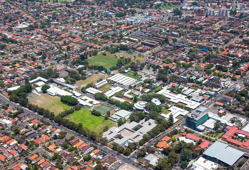
Contents |
1 Introduction
1.1 Name of this DCP
1.2 Land to which this DCP Applies
1.3 Purpose of this DCP
1.4 Relationship to other Plans
1.5 Consent Authority
1.6 Application of this DCP
1.7 Procedures for Development Applications
1.8 Objectives
1.9 Stage 1 development applications
2 Vision, Principles and Indicative Concept
2.1 Vision
2.2 Development Principles
2.3 Desired Future Character
2.4 Indicative Concept Plan
3 Public Domain 11
3.1 Infrastructure 11
3.2 Street Design Controls
3.3 Street Network and Design
3.4 Open Space Network and Landscaping
3.5 Heritage
4 Design Controls
4.1 Building Height
4.2 Minimum Building Setbacks
4.3 Transport, Traffic and Parking
4.4 Building Design and Materials
4.5 Mixed Use Development
4.6 Utilities and Site Features
4.7 Affordable Housing
5 Environmental Management and Sustainability
5.1 Contamination 33
Figures
Figure 1 Land to which this DCP Applies
Figure 2 Character Precincts
Figure 3 Indicative Concept Plan
Figure 4 Stormwater system
Figure 5 Street Network 14
Figure 6 Open Space Network
Figure 7 Landscaping and Public Domain
Figure 8 Heritage Plan (and curtilage areas)
Figure 9 European Archaeological Heritage
Figure 10 Aboriginal Archaeological Heritage
Figure 11 Indicative Building Edge Heights in Key Areas
Figure 12 Specific Architectural Response
Tables
Table 1 Key Elements 8
Table 2 Indicative Street Dimensions
Table 3 Primary Building Setbacks
Table 4 Parking Rates
|
Attachment 1
|
|
1 Introduction |
This document provides a framework to guide development of the Newmarket Green site in Randwick identified as a ‘Key Site’ under Randwick Local Environmental Plan 2012.
1.1 Name of this DCP
The DCP has been prepared in accordance with the provisions of section 74C of the Environmental Planning and Assessment Act 1979 (the Act). The DCP was adopted by the Secretary of the Department of Planning and Environment on 30 March 2015.
1.2 Land to which this DCP Applies
The provisions of this chapter apply to development within the Newmarket Green site as shown in Figure 1. The site is generally bounded by Barker, Jane, Young, Middle and Botany Streets. Young Street and Middle Street dissect the site in a north-south and east-west direction respectively.
Figure 1 Land to which this DCP Applies
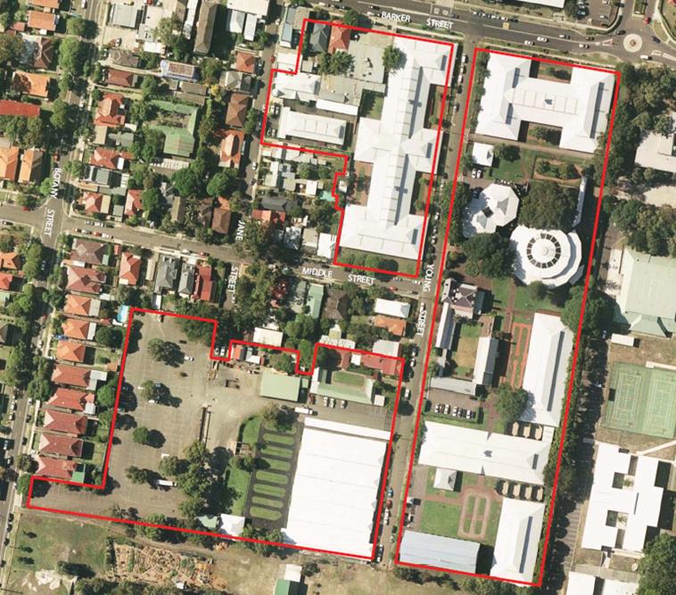
1.3 Purpose of this DCP
The purpose of this DCP is to guide future development of the Newmarket Green site by:
» Identifying the vision, development principles, key elements and indicative concept for the future development of the site
» Communicating the planning, design and environmental objectives and controls against which the consent authority will assess future development applications
» Providing for the celebration of heritage items and provision of open space
» Encouraging environmentally sensitive development and sustainability
» Ensuring the provision of infrastructure to service development of the site
» Promoting high quality urban design outcomes
» Providing for diverse housing including affordable housing.
This section of the DCP should be read in conjunction with:
· Part A- Introduction and Part B General Controls
· Other sections of the DCP for specific development types, locations or miscellaneous controls as relevant to any particular DA.
1.4 Relationship to other Plans
This DCP supplements the Randwick Local Environmental Plan 2012 by providing specific development guidance for the Newmarket Green site. Development within the site will need to have regard to this DCP as well as relevant provisions in the Randwick DCP 2013 as noted above.
1.5 Consent Authority
Unless otherwise authorised by the Act, Randwick City Council is the consent authority for development applications applying to the Newmarket Green site.
1.6 Application of this DCP
This DCP contains objectives and controls relating to various aspects of development at Newmarket Green. The objectives enable Council and applicants to consider whether a particular proposal will achieve the development outcomes established for the site. The consent authority may consider reasonable alternative solutions that achieve the overall vision, objectives and development principles as well as the specific objectives of the controls that demonstrate improved public benefits and design excellence can be achieved.
1.7 Procedures for Development Applications
Information requirements for development applications are set out in Part 2 of the Randwick DCP 2013. Notification of development applications will be undertaken in accordance with Part 3 of the Randwick DCP 2013.
1.8 Objectives
The objectives of this section are to ensure that future development:
- will result in an environmentally sustainable precinct
- exhibits design excellence and incorporates high quality materials and finishes
- provides for high quality publically accessible open space that responds to heritage values of the site
- responds to the heritage context of the site and the surrounding fine grain neighbourhood
- provides for housing types that meet the needs of key workers and students, including affordable housing
- respects the existing low scale residential character, adjoining schools and public open space
- incorporates adequate internal carriageway widths to provide a safe pedestrian and cycle network
1.9 Stage 1 development applications
Council’s preference is for a stage 1 development application (or concept application) to be submitted prior to the approval of any other development application. The stage 1 application shall include the following:
- proposed subdivision including public open space;
- how the permitted gross floor area is to be distributed throughout the site (on a block by block basis) consistent with the permitted FSR for the site under Randwick LEP 2013;
- road infrastructure layout including sections, design/treatment of pavements, verges and bicycle network (refer section 3.1) as part of a traffic management plan for the site;
- any off-site traffic management or public domain measures to be undertaken and staging of these works;
- car parking provision across the site consistent with Council’s DCP Section B7;
- relocation of any existing drainage infrastructure. In circumstances where relocation of infrastructure is not possible, alternative approaches such as identifying necessary easements and overland flow paths should be submitted; and
- identify opportunities for deep soil planting within development lots, including front setbacks (refer section 3.1)
Note: A stage 1 development application means a staged development application within the meaning of section 83B of the Environmental Planning and Assessment Act 1979 for the land to which this DCP applies.
- 2 Vision, Principles and Indicative Concept
2.1 Vision
Newmarket Green will be a high quality, socially cohesive and sustainable development that celebrates the unique landscape and built heritage of the site, in a manner that supports the growth of Randwick’s Education and Health Strategic Centre, through the delivery of open space, diverse housing including affordable housing and complementary uses.
2.2 Development Principles
To achieve this vision, development of the Newmarket Green site is to:
» Create new publically accessible open spaces that will act as gathering spaces and opportunities for passive recreation
» Ensure landscaping and the design of the public domain areas incorporate the retention of significant trees, where appropriate, to create a high quality urban environment
» Incorporate sustainability measures that reduce the site’s impact on the natural environment
» Provide for stormwater management to ensure no properties downstream of the development site will be adversely affected
» Strengthen the role of Newmarket Green as a contributor to housing and employment within the Education and Health Strategic Centre
» Provide a range of housing including affordable housing that will increase choice and diversity in the area
» Support the CBD-East Sydney light rail by providing commercial and residential floor space for a growing community
» Transition building heights in response to surrounding heritage items and the Struggletown Conservation Area
» Create high quality streets and public spaces that provide for safe and efficient movement of pedestrians, cyclists and vehicles through the site
» Improve the permeability of the neighbourhood by extending existing, and creating new a new street network
» Celebrate the site’s heritage through the adaptive reuse of the Big Stable and Newmarket House and the creation of public view corridors to and from these items
» Encourage neighbourhood-scale commercial activity along Barker Street and the site’s heritage items
» Provide for affordable housing to meet the needs of the local community and key workers.
2.3 Desired Future Character
Newmarket Green is defined by three distinct precincts. Each precinct has a distinct desired future character that is to be reflected in the design of built form and public domain. All development at Newmarket Green is to contribute to achieving the desired future character within each precinct.
The three precincts are shown in Figure 2 and are described below.
Barker Street Precinct
This is the most urban precinct reflecting the growth and scale of the Randwick Education and Health Strategic Centre. Focused on Barker Street, non-residential uses at the ground floor should create an active and vibrant interface along the street frontage. Active uses, with shop-fronts and outdoor seating, are encouraged on the ground floor.
A generous building setback (5 metre) to Barker Street will create a comfortable pedestrian environment, protected by awnings and street trees.
The public domain along Barker Street will enhance the pedestrian experience by providing:
» Street trees planted at regular intervals
» High quality block style pavers within the 5m setback
» Consistent awning and pedestrian scale lighting.
The balance of the Barker Street buildings will accommodate a range of uses to meet market demand and contribute to the Specialised Centre. This may include medical offices associated with the Hospital, and/or research or office space associated with the University of NSW, mixed with housing that will appeal to workers and users of the Specialised Centre – such as students and key hospital workers. Opportunities for partnerships with the adjacent Hospital and/or University should be encouraged, where possible.
Buildings range in height to respond to surrounding character. Close to Struggletown, buildings scale down in height to a maximum of 10 metres and are set back from the western boundary. Along Barker Street, buildings to a maximum height of 25 metres will provide a balance to the adjacent Hospital and create a prominent building alignment along Barker Street.
Transition of building height will occur between the lower scale existing residences adjacent to the site. Setbacks along Young Street are also encouraged, to allow for soft landscaping along the building edge and opening up of view corridors to Newmarket House.
Significant trees along the eastern boundary (adjoining Randwick Girls High School) and along Middle Street should be retained and building setbacks and footprints (including basements) designed to protect these trees and their root systems.
In the block on the western side of Young Street, south of the B1 Neighbourhood Centre zone, residential development will be integrated with the character of the surrounding residential properties in Struggletown Conservation Area. Built form in this block is designed to provide a fine grain element to Newmarket Green that responds to the low-scale character of Struggletown. Building heights will transition from lower scale along Middle Street, up to a higher scale at Young Street.
Buildings along Middle Street will incorporate setbacks to allow for the retention of significant trees. The setbacks will complement the transition in building heights to Struggletown, with a 2 storey building height at the street edge, stepping up and back to a height of 21 metres. This will create a transition to lower scale residences to the west along Middle Street. Adjacent to Newmarket House on the opposite side of Young Street, the eastern façade will incorporate a specific architectural response to ensure a high quality outlook from the park that complements Newmarket House and Gardens in the design, massing and selection of building materials and colours.
Eastern Precinct
This is the largest and most prominent space in Newmarket Green. It is characterised by the heritage listed buildings and landscapes that reflect the history of Newmarket Green, and which are to be celebrated through new open space and public domain areas.
A new public open space is located alongside Newmarket House and gardens, which incorporates the Sales Ring precinct. The focus of this open space will be the central Moreton Bay Fig Tree, as well as opportunities to celebrate the historic significance of the site through public art and interpretive features.
A second prominent public domain area will be the Big Stable and its curtilage at the southern end. An area of open space outside the Big Stable – known as Big Stable Square – will be defined by a formal shape to encourage public gathering and activity. Durable ground treatments, such as crushed gravel and porous paving, are encouraged to enable markets and other active uses in the Square.
Pedestrian connectivity and views between open spaces and public domain areas is to be encouraged through a north-south pedestrian link. Buildings in this precinct will range from 12 metres up to 25 metres, with low-rise elements adjacent to the retained heritage buildings and upper storeys set back. The following building envelopes shall be incorporated:
» Big Stable – Buildings should generally be set outside of the curtilage to create an outdoor civic space, to respect the scale of the Big Stable. Upper building elements to the north will be setback by at least 12 metres from the Big Stable, or so that the upper levels are entirely outside of the curtilage.
» Newmarket House and Garden – Building elements immediately adjacent to Newmarket House will be limited to 4 storeys within a transition zone. Upper storeys (up to 25 metres) will be setback from the heritage item, and focused in the centre of the site or along the eastern boundary.
Paine Reserve Precinct
Adjacent to the southern boundary of Newmarket Green, the focus is to maximise opportunities for passive surveillance of Paine Reserve whilst maintaining a transition of building heights to adjacent lower scale residential areas to the north and west.
Streets will be used to create view corridors, new access points to the site and to provide additional amenity to adjacent properties. A new street along the southern boundary will open up a new view corridor to the Big Stable from the west. A rear laneway along the western boundary abutting neighbouring properties fronting Botany Street, will provide a significant building separation to future development, benefiting the neighbouring properties to the west.
Built form and building heights in this precinct will be carefully considered to achieve good amenity and respond to surrounding heritage items, Paine Reserve and neighbouring sites:
» Mid to high-rise buildings (up to 25 metres) will be located along the southern boundary to create a prominent southern edge to the site and opportunities for passive surveillance of the neighbouring park. An articulated façade along the park edge will provide a high quality architectural finish when viewed from Paine Reserve. The northern edge of the building – facing terrace houses to the north – is to be set back by at least 2 metres from the street edge and has a reduced building height at the street edge (approximately 5 storeys). Upper floors are to be setback from the building edge.
» Building heights along the Young Street frontage will be scaled down (to approximately 4 – 5 storeys) to create a balance to the Big Stable. Upper storeys to 25 metres will be set back from Young Street. An architectural response will be required along the eastern facade of this building (Young Street frontage) that responds to, and provides an attractive view from, the Big Stable Square.
» Buildings along the western edge adjoining properties fronting Botany and Middle Streets will be a maximum of 10 metres so as to not dominate adjacent smaller scale dwellings. A two-storey difference in the relative ground level of the site and neighbouring properties to the west means the scale of buildings in this precinct will naturally appear reduced. On its eastern frontage along the Jane Street extension, the building will transition up to 18 metres, providing a balance to buildings on the opposite side of the street.
There is an opportunity to position a specific architectural or massing feature (2 storeys) on the building at the south western corner of the site to terminate views from Young Street / Big Stable Square down the new southern thoroughfare. The development block is set back from the new southern street to enhance this view.
Figure 2 Character Precincts
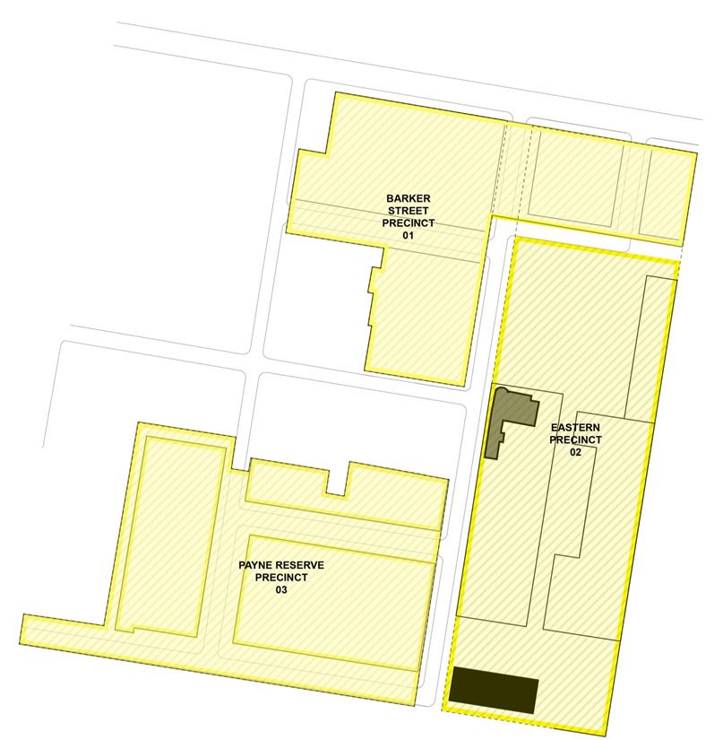
|
|
PRECINCT BOUNDARY |
|
|
NEWMARKET HOUSE |
|
|
BIG STABLE BUILDING |
|
|
SITE BOUNDARY |
2.4 Indicative Concept Plan
Objectives
1. Ensure that development of Newmarket Green occurs in a coordinated manner consistent with the vision and development principles for the site.
2. Ensure the key elements of the site are delivered, whilst providing a degree of flexibility as to the final layout and design of the site.
3. Ensure that the overall development complies with the maximum height and floor space ratio development standards for the whole site contained in Randwick LEP 2012.
Controls
1. Development is to be generally consistent with the indicative concept plan in Figure 3 and key elements described in Table 1. Where variations are proposed, a development application shall demonstrate how the vision, development principles, key elements and relevant objectives are still able to be achieved.
Table 1 Key Elements
|
Element |
Description |
|
Residential community |
– A transition from low to medium density residential development in the R1 General Residential Zone ensuring each block complies with the maximum 1.3:1 FSR across the whole site – A range of housing types to broaden housing choice in the area, including more affordable options to meet market demand and accommodate key workers, students and other emerging demographic groups in the locality – A mix of uses within the B1 Neighbourhood Centre zone at Barker Street that will attract pedestrian activity, vitality and contribute to the creation of a vibrant place that serves the needs of the local community |
|
Affordable housing |
– Provision of affordable housing across the site is required to accommodate key workers close to employment and services – Affordable housing rented to low and moderate income households in accordance with the Randwick City Council Affordable Rental Housing Program and Procedures – Affordable rental dwellings are designed and constructed to a standard which is consistent with other dwellings within Newmarket Green – Affordable housing that contributes to a sustainable and stable local work force |
|
Open space |
– A new public open space with a minimum area of 5,000m2 comprising a single area that is not intersected by any other use to provide for a range of recreation opportunities with minimum dimensions of 66 metres by 76 metres. The configuration, location and right of public access to the public open space should be appropriate for its purpose. – The public open space should be designed with two street frontages to provide good public access and opportunities for passive surveillance. – New open space around key heritage items – the Big Stable and Newmarket House – Design of landscaping and public domain areas to soften the appearance of the built form, create high levels of amenity and provide a focal point for passive recreation for the local community and respite for Hospital workers and visitors
|
|
Heritage |
– Adaptive reuse of the Big Stable building and Newmarket House to encourage activities, including retail, cafes or restaurants, and the like – Retention, celebration and interpretation of the historic Sales Ring within the new public open space – Retention of significant trees that contribute to the site’s cultural significance – Building and landscape design that complements on-site heritage items and the Struggletown Conservation Area |
|
Built form |
– Building heights ranging from 10 metres to 25 metres – Low rise (10 – 12 metres) adjacent to Struggletown, the Big Stable, along Middle Street, and in response to the level change between Botany Street and the site – Midrise (18 – 25 metres) in transition areas outside of significant views, along Barker Street, the eastern boundary, Paine Reserve and set back from key roads (Young Street) and open space – Varied and dispersed building heights and setbacks to create an interesting, dynamic urban form that respects the scale of heritage items and adjacent properties |
|
Movement network |
– A series of new local streets and lanes to enhance connectivity, and provide views to key heritage items and open space – A new southern thoroughfare adjacent to Paine Reserve to create a new access option through the site – Extension of the existing Jane Street to the new southern thoroughfare to complete the original grid pattern of the locality – A series of pedestrian and cyclist thoroughfares to enhance connectivity to surrounding areas, including the Prince of Wales Hospital and Paine Reserve |
|
Sustainable Design |
– Incorporate waste management and environmentally sustainable development – Minimise greenhouse gas emissions – Minimise water use and encourage water re use on the site – Encourage less car dependency |
Figure 3 Indicative Concept Plan
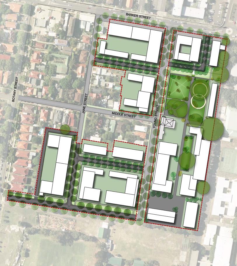
|
|
SITE BOUNDARY |
3 Public Domain
3.1 Infrastructure
Any Stage 1 or concept development application submitted for the whole site must address all new infrastructure necessary for redevelopment of the site and changes to the existing infrastructure. The Stage 1 DA shall include sufficient documentation/evidence demonstrating compliance with DCP section B8- Water Management and Council’s Private Stormwater Code. The following matters shall also be addressed:
1. The critical 1% AEP flood level must be established for all areas across the development site. Council has not undertaken any flood modelling for the subject catchment. The impact of a 1% AEP storm event on the proposed development will need to be fully assessed.
2. Sufficient documentation/evidence indicating that the proposed development will not increase the depth of overland flow in areas outside the development site and that no property downstream of the development site will be adversely affected as a result of the proposed development for storm events up to the 1 in 100 year ARI event.
3. In relation to the proposed site stormwater drainage system, sufficient documentation/evidence that the new system will not increase the depth of overland flow in areas outside the development site, will not adversely impact on Council’s stormwater drainage infrastructure and that no property downstream or upstream of the development site will be adversely affected as a result of the proposed development for storm events up to the 1 in 100 year ARI / 1% AEP event.
4. The proposed internal roadways, any drainage easements and overland flow routes will drain the 1 in 100 year storm event and to consider personal and structure safety and the hazard factor, (product of velocity and depth of flow). This safety factor shall not exceed a value of 0.4 at any location. (i.e. VD< 0.4).
5. The internal pipe system shall cater for the critical 1 in 20 year ARI / 5% AEP storm event with overland flows contained within the roadways or other suitable flow paths for up to the 1 in 100 year / 1% AEP storm event.
6. Details showing indicative pipe sizes, pit locations, pipe locations and any associated drainage easements, inter-allotment drainage pipelines and associated inter-allotment drainage easements. Plans must identify the road network, pipe/pit network, catchments draining to the various pipes/drainage pits, location of potential overland flow paths, levels of properties adjacent to overland flow paths and level information on the roads in general.
7 Diagrams showing the relocation of any existing drainage infrastructure. In circumstances where relocation of infrastructure is not possible, alternative approaches such as identifying necessary easements and overland flow paths should be submitted.
The existing stormwater system is shown in Figure 4 below:
Figure 4 Stormwater System
3.2 Street Design Controls
Any Stage 1 development application shall incorporate a traffic management plan demonstrating that the internal road system has sufficient capacity to accommodate the needs of the proposed development and safety of all users. In this regard the following details shall be included:
1. A
road safety audit shall be prepared and submitted for all internal roads.
Separated cycle ways or shared paths should be investigated as part of this
audit. One way streets will not be considered unless appropriate consultation
with Council’s Traffic Committee and the Roads and Maritime Service has been
undertaken and approvals have been granted in accordance with the Roads Act.
2. Swept path details/analysis for
a 9.5 metre garbage truck, (10.5 metre turning radius) for the provision of
civil infrastructure for this site. The applicant shall note that satisfactory
collection of domestic waste must be considered when designing the road network
and or travel lane/footpath/parking lane configuration of the road network.
3. For streets that have residential development fronting both sides of the street – streets shall be designed to provide a minimum of 2.3 metre wide parking lanes and 3.2 metre travelling lanes on both sides/ directions of the roads. The verge widths shall be a minimum of 3.0 metres in width on both sides, (with a minimum 1.5 metre wide footpaths to be constructed), creating a minimum 11 metre wide carriage way and a minimum 17 metre wide road reserve.
4. For streets that have residential development fronting only one side, the parking lane on the other side may be omitted as no street parking demand is being generated. Thus narrowing the carriage way and road reserve by minimum 2.3 metres respectively.
5. For one way streets, regardless that both sides have residential development fronting the street, the developer shall achieve a minimum 2.3 metre wide parking lane on the left hand side with a 3.2 metre wide travelling lane measured to the lip of the gutter. Thus a carriageway width being 5.95 metres be attained. With 3.0 metre wide road verges and 1.5 metre wide footpaths on both sides creating an 11.75 metre wide road reserve.
6. The performance of intersections and the road network must be suitable for waste management vehicles, removalist trucks, emergency vehicles, construction traffic. Road intersections shall be designed with a minimum turning radius of 10.5 metres. Larger trucks such as 12.5 metre removalist trucks must be able to navigate the intersections without mounting kerbs, but may mount medians provided that the medians are to be suitably reinforced. All future development applications for civil infrastructure within this site must demonstrate compliance with this requirement.
3.3 Street Network and Design
Objectives
1. Provide safe, efficient and legible movement of pedestrians, cyclists and vehicles.
2. Design streets as spaces for people to enjoy, as well as move through incorporating high quality materials.
3. Create a hierarchy of streets that promotes good connectivity with the existing street network.
4. Promote direct vehicle access to the site from Young Street and Botany Street, and direct new vehicle movements away from Jane Street and Middle Street.
5. Create a slow speed environment and naturally calm traffic through street design.
6. Provide new on-street parking.
7. Make adequate provision for footpaths, street trees, services and drainage.
8. Enhance the current width and ‘local street’ function of Young Street.
Controls
1. The street network including pedestrian and cycle infrastructure must be constructed in accordance with Council’s requirements prior to the issue of the first occupation certificate and the layout is to be generally consistent with Figure 5.
2. New streets are to be generally consistent with the parameters in Table 2.
3. Variations may be considered to the requirements in controls 1 and 2 above, where the above objectives and the following essential thoroughfare connections are satisfied:
a. A new thoroughfare along the southern boundary of the site connecting Botany Street to Young Street.
b. Extension of Jane Street connecting to a new southern thoroughfare.
c. A rear laneway along the western boundary of the site (where the site adjoins properties fronting Barker Street) to create additional building separation.
d. New east-west streets connecting Young Street and Jane Street.
4. To cater for safe pedestrian movements across Barker Street, a pedestrian crossing shall be constructed across Barker Street to the satisfaction of Randwick City Council and NSW Roads and Maritime Services. Any signalisation of the pedestrian crossing shall meet the warrants for signals in accordance with the RMS document titled “Traffic Signal Design: Section 2- Warrants”.
5. The applicant shall consult with Sydney Buses in relation to any temporary relocation of the bus stop along Barker Street (near the intersection with Young Street) that may be required during construction. The applicant shall reinstate the bus stop on Barker Street to the satisfaction of Sydney Buses.
6. New streets as shown in Figure 4 including pedestrian paths and cycleways within the public domain shall be dedicated to Council.
Provide for a continuous pedestrian and cycling network through the site to connect to the broader street network.
Figure 5 Street Network
![]()

|
|
DRIVE 1 (DV1) SOUTHERN PARK EDGE |
|
|
STREET 1 (ST1) BARKER STREET ENTRY |
|
|
STREET 2 (ST2) EAST - WEST LINK |
|
|
STREET 3 (ST3) EAST - WEST LINK |
|
|
STREET 4 (ST4) JANE STREET EXTENSION |
|
|
REAR LANE (RL) |
Table 2 Indicative Street Dimensions
|
Street Type |
Reserve(1) (min) |
Carriage-way |
Parking |
Verge (min) |
Footpaths |
Traffic Lanes |
Movement type |
|
DV1 Southern park edge Botany Street to Young Street |
14.0m |
8.7m |
1 x 2.3m
|
3.0m |
1 x 1.5m
|
Two travel lanes (3.2m), one in each direction |
Slow, reduced speed (30km/hr design speed) |
|
ST1 Barker Street entry Barker Street to Young Street |
17m |
11.0m |
2 x 2.3m |
6.0m |
2 x 1.5m |
One travel lane (3.2m), with two way traffic and passing opportunities |
Yield*, reduced speed (15km/hr design speed) |
|
ST2 East - west link Jane Street to Young Street (north of Middle St) |
13.8m |
7.8m |
2 x 2.3m |
6.0m |
2 x 1.5m |
One travel lane (3.2m), with two way traffic and passing opportunities |
Yield*, reduced speed (15km/hr design speed) |
|
ST3 East - west link Jane Street to Young Street (south of Middle St) |
13.8m |
7.8m |
2 x 2.3m |
6.0m |
2 x 1.5m |
One travel lane (3.2m), with two way traffic and passing opportunities |
Yield*, reduced speed (15km/hr design speed) |
|
ST4 Jane Street extension Jane Street to DV1 |
13.8m
|
7.8m |
2 x 2.3m |
6.0m |
2 x 1.5m |
One travel lane (3.2m), with two way traffic and passing opportunities |
Yield*, reduced speed (15km/hr design speed) |
|
RL Rear laneway DV1 to Jane Street |
6.0m |
5.0m |
None |
1.0m |
None
|
Two travel lanes (min 3m), one in each direction |
Slow, reduced speed (15km/hr design speed) |
(1) The reserve width / verge width varies in some locations where specific building setbacks are to be achieved, or where building elements protrude into the setback to achieve a specific architectural response.
(2) At the entry to the site from Botany Street, the fixed position of existing properties to the north fronting Botany Street will require a reduction of the road reserve of 1 metre.
* Yield = single travel lanes require opposing vehicles to yield and utilise spaces between parked cars and driveways, etc.
3.4 Open Space Network and Landscaping
Objectives
1. Create distinctive open space and public domain areas that respond to, and celebrate, the site’s cultural values, heritage items and significant streets.
2. Provide a network of connected open spaces that are safe and secure for all users.
3. Create and maintain significant view corridors to, and through, the site.
4. Ensure high quality open space and public domain areas adjoin Newmarket House and the Big Stable.
5. Design open space and public domain areas in a manner that promotes a range of passive activities and different degrees of social interaction.
6. Ensure that landscaping adjacent to Newmarket House displays the qualities of elegance and simplicity.
7. Facilitate pedestrian and cyclist connectivity through the site.
8. Encourage landscape design that provides for increases in ecological and cultural value through natural, endemic vegetation and existing heritage landscapes.
9. Maximise the interface between development and public open space to provide enhanced levels of residential amenity and casual surveillance of the surrounding public open space.
Controls
1. Open space is to be provided generally in accordance with Figure 6.
2. Public open space shall comprise a single area that is not intersected by any other use to provide for a range of recreation opportunities with minimum dimensions of 66 metres by 76 metres. The configuration, location and right of public access to the public open space should be appropriate for its purpose. The public open space should be designed with at least two street frontages to provide good public access and opportunities for passive surveillance.
3. Public open space shall incorporate native vegetation and, where appropriate, shall meet the requirements of section B4- Landscaping and Biodiversity of Council’s DCP.
4. Ensure buildings fronting the public open space are designed at ground level to provide adequate separation between units and the public domain to ensure the public nature/function of the public open space is not compromised. This may include raising of ground level apartments, setbacks and appropriate landscaping.
5. All development is to be designed to retain significant views and allow for pedestrian connectivity identified in Figure 6.
6. A view analysis is to be submitted with Development Applications that impact, or have the potential to impact, on significant views.
7. Landscaping and public domain design, including retention of significant trees, shall generally be in accordance with Figure 7.
A landscape and public domain plan shall be submitted with all Development Applications proposing open space or public domain areas, and shall address the following (where appropriate):
a. The retention of significant trees accompanied by an arborist’s report for any pruning
b. Appropriate street tree planting spaced at regular intervals, on new streets
c. Appropriate lighting in the public domain
d. An appropriate response to the cultural landscape and heritage items, which investigates opportunities for the retention of existing timber benches, plaques, sandstone elements and gardens.
e. Rainwater infiltration to minimise run-off and minimal amount of hard surface area
f. Water efficient irrigation systems and use of non-potable water sources
g. Details of planting, paving, fencing, soil depth
h. Appropriate sunlight access
i. Provision of overland flow paths from north to south through the site
j. High quality materials and finishes including paving, stone, stainless streel and pre-cast concrete
Note: Refer to tree retention requirements of Clause 5.9 and 5.9AA of Randwick LEP.
Figure 6 Open Space Network
|
|
OPEN SPACE AREAS |
|
|
|
|
NEWMARKET HOUSE |
|
|
|
|
BIG STABLE BUILDING |
|
|
|
|
PEDESTRIAN THOROUGHFARE |
|
|
|
|
VIEW CORRIDOR |
|
|
|
|
|
||
Figure 7 Landscaping and Public Domain
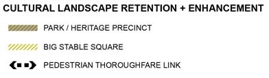
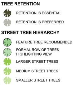
3.5  Heritage
Objectives
1. Ensure the heritage significance of the site is conserved, appropriately managed and respected by all new development.
2. Celebrate and interpret the heritage significance of the site in the design of buildings and open space.
3. Provide opportunities for public access to, and appreciation of, retained heritage items.
4. Create opportunities for adaptive reuse of Newmarket House and the Big Stable building.
5. Ensure new development is designed to respond to the heritage character of the Struggletown Conservation Area.
6. Ensure Aboriginal heritage is appropriately considered and managed through the development process.
Controls
1. The Big Stable building and Newmarket House are to be retained. Adaptive reuse of these buildings must be in accordance with a Conservation Management Plan submitted with any Development Application that proposes development (including a new use) of these buildings. The Conservation Management Plan must demonstrate:
a. The proposed use is compatible with the significance of the heritage item
b. Provision for on-site interpretation has, or will, be made
c. That curtilage areas in Figure 8 are maintained and any development within the curtilage (including landscaping) is appropriately sited and designed to respond to the heritage items
d. That development, including alterations and additions, will maintain significant building fabric and building elements and allows for the appreciation of their significance
e. That consultation with relevant authorities has been carried out in accordance with the relevant legislation.
2. The Moreton Bay Fig Tree within the Sales Ring precinct is to be retained within the public open space and incorporated into a landscape plan for the land in zone RE1. An arborist report shall be submitted prior to any development directly adjacent to the Moreton Bay Fig Tree to advise on development setbacks in order to ensure protection of the root system and viability of the Moreton Bay Fig Tree and any proposed pruning.
3. All development within the Sales Ring precinct must be in accordance with an Interpretation Plan and conservation management plan prepared as part of a Development Application for that land. The Interpretation Plan shall outline the proposed method of interpretation of the Sales Ring through landscaping and design features that respond to its historic geometry and use (and may be incorporated with a landscape plan prepared as a requirement of control 2 above).
4. Public domain features, such as the stone kerbing in the Struggletown Conservation Area, are to be retained where they contribute to the heritage significance of the Conservation Area.
5. Development in areas identified as having High or Moderate Archaeological Sensitivity in Figure 9 will require an Archaeological Assessment to be carried out in accordance with relevant legislation and guidelines, as part of a Development Application.
6. Development in areas identified as requiring further archaeological investigation or monitoring in Figure 10 will require appropriate assessments to be carried out in accordance with the relevant legislation and guidelines, as part of a Development Application.
Note: Refer to heritage requirements of Clause 5.10 of Randwick LEP.
Figure 8 Heritage Plan (and curtilage areas)
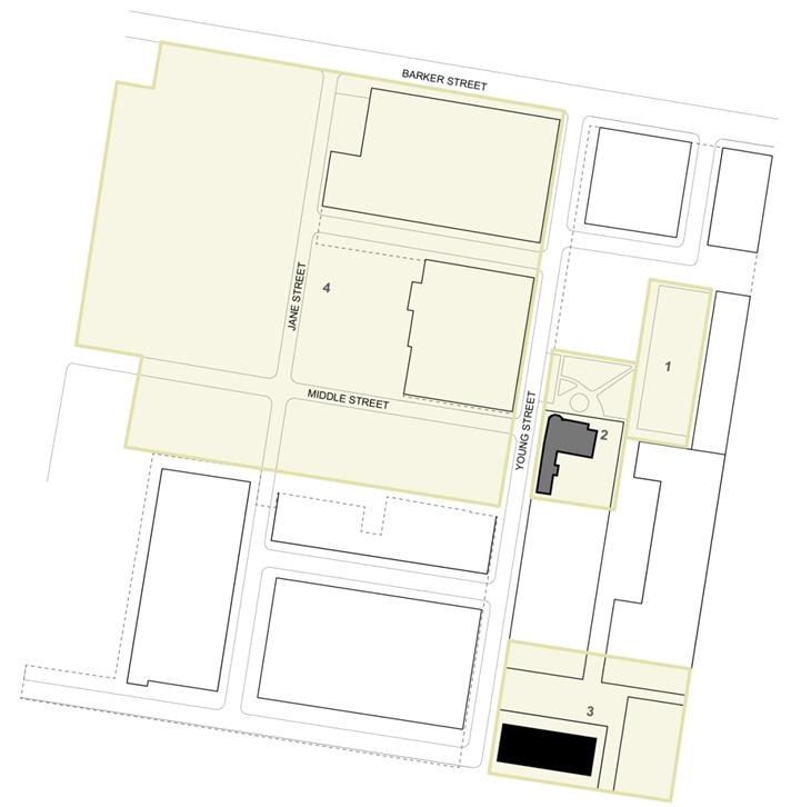
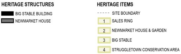
Figure 9 European Archaeological Heritage
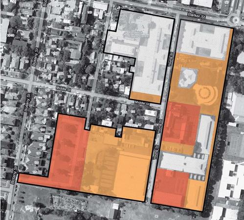
|
|
LOW ARCHAEOLOGICAL SENSITIVITY |
|
|
MODERATE ARCHAEOLOGICAL SENSITIVITY |
|
|
HIGH ARCHAEOLOGICAL SENSITIVITY |
Figure 10 Aboriginal Archaeological Heritage
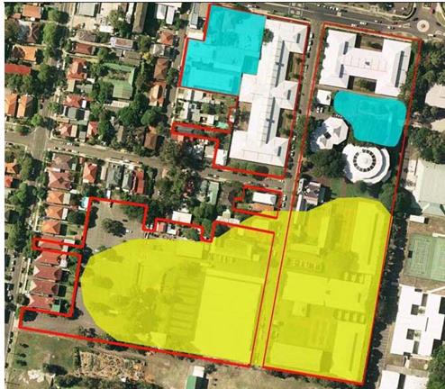
|
|
FURTHER INVESTIGATION MAY BE REQUIRED |
|
|
POST DEMOLITION MONITORING MAY BE REQUIRED |
4 Design Controls
4.1 Building Height
Objectives
1. Ensure buildings transition in height to complement the scale of adjacent development.
2. To consider solar access to the adjoining community garden, adjoining properties and on-site open space.
3. Ensure building heights contribute to the creation of high quality and comfortable open spaces.
4. Minimise the impact of development on heritage items on site.
5. Ensure building heights in the immediate vicinity of the Struggletown Conservation Area and surrounding residential areas reflect the lower scale of development.
6. Facilitate passive surveillance of streets and open space, including off-site open space at Paine Reserve.
7. Allow for variation in massing and building heights to create visual interest, distribute the bulk of the building and minimise amenity impacts on adjoining properties and the streetscape.
8. Allow for flood mitigation measures to be incorporated into the design of new buildings.
Controls
1. To provide a height transition to key areas such as heritage items, the Heritage Conservation Area of Struggletown and on-site public open space, building heights at the street edge are to be generally consistent with Figure 11.
2. Buildings directly adjacent to Newmarket House, which are located within the height transition area in Figure 11, are to be a maximum of 4 storeys. Upper levels (above 4 storeys) are to be set back outside the height transition area.
3. Roof forms, plant rooms and lift overruns are to be designed to be simple compact forms that are visually unobtrusive.
Note: Maximum building heights (in metres) are set out in the Randwick LEP. State Environmental Planning Policy 65 – Design Quality of Residential Flat Development contains guidelines for building separation distances between upper levels and maximum floor to ceiling heights.
Figure 11 Indicative Building Edge Heights in Key Areas
![]()
![]()
![]()
![]()
![]()
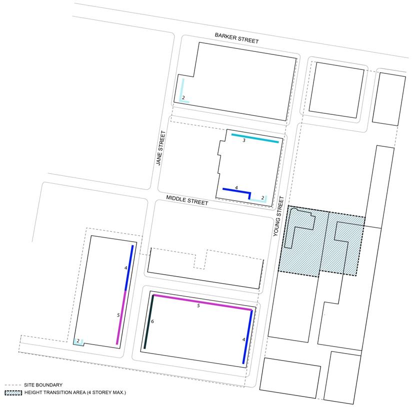
|
|
HEIGHT TRANSITION AREA (4 STOREY MAXIMUM) |
|
MAXIMUM BUILDING EDGE HEIGHTS (STREET WALL) |
|
|
|
2 STOREY |
|
|
3 STOREY |
|
|
4 STOREY |
|
|
5 STOREY |
|
|
6 STOREY |
4.2 Minimum Building Setbacks
Objectives
1. Control the appearance of bulk and scale in the built form.
2. Ensure an appropriate scale around heritage items and within the Struggletown Conservation Area.
3. Provide adequate separation between buildings and public domain for landscaping.
4. Provide strong street edges, particularly along Barker Street and Paine Reserve frontage, and a clear delineation between public and private domain.
5. Create view corridors and encourage the retention of significant views.
6. Create private open space for residential uses within the private frontage of development blocks, including at ground level.
Controls
1. Building setbacks are to be generally in accordance with Table 3 below.
2. Buildings are to be sited to form a strong, predominantly continuous building edge to the primary street frontage or adjoining open space.
3. Projections into front building setbacks for sun shading devises, fin walls and similar vertical screening are permitted, and should be setback at least 0.5 metres from property boundaries and from streets.
4. Variations to the setback controls may be permitted to encourage building articulation and visual interest. Architectural elements permitted within the building setbacks include building attachments, balconies, terraces, porches, bay windows, planters and the like.
Table 3 Primary Building Setbacks
|
Setback from |
Setback requirement (minimum) |
|
Street frontages: |
|
|
Barker Street |
5.0m |
|
Jane Street |
5.0m (in B1 zone) 3.0m (in R1 zone) |
|
Young Street (west side) |
3.0m |
|
Young Street (east side) |
6.5m in B1 zone 3.0m in R1 zone |
|
Middle Street |
3.0m (for 2 storey elements) 7.0m (for elements above 2 storeys) Note: additional setback to accommodate tree retention on northern side of Middle Street required |
|
New streets (ST1, ST2, ST3, ST4, DV1) |
2.0m (to ST2) in B1 zone 0.5m (to ST1) in B1 zone 3.0m (to DV1, ST2, ST3, ST4) in R1 zone 0.5m (to RL) in R1 zone |
|
Interfaces: |
|
|
Eastern boundary (interface with schools) |
1.0m Note: additional setbacks may be required to accommodate tree retention |
|
Southern boundary (interface with school) |
3.0m |
|
Rear boundary (building interface with Struggletown) |
4.0m
|
4.3 Transport, Traffic and Parking
Note: Applicants are advised to refer to Part B7 of Randwick DCP for further Transport, Traffic, Parking and Access controls to be addressed at Development Application stage. The controls in this section prevail where there is any inconsistency with the controls in Part B7 of Randwick DCP.
Objectives
1. Reduce car dependence and encourage sustainable travel by encouraging the use of public transport, walking and cycling as modes of travel.
2. Provide sufficient and convenient parking for residents and visitors with vehicular access that is simple, safe, and direct.
3. Ensure appropriate provisions for service and delivery vehicles for non-residential uses, and minimise the use of on-street parking for loading where appropriate.
4. Limit the amount of site area devoted to driveways and parking, and integrate these elements within the building design.
5. Encourage sustainable travel and minimise the amount of on-site parking to be provided through a range of green travel arrangements.
Controls
Vehicle access
1. Shared basements are encouraged to minimise the number of vehicular crossings. Vehicle access to basement car parking for buildings along the eastern boundary of the site shall be via a shared basement entry / exit from Young Street.
2. Where required due to the adjacent flood conditions, basement car parking facilities should incorporate safe evacuation features in the event of a storm, flood or rainfall event.
Parking
Note: Applicants are advised that Part B7, Section 3.3 of Randwick DCP provides for exceptions to the parking rates in Randwick DCP where suitable and sustainable transport alternatives are considered and incorporated into the development. The parking rates in this section expand on the provisions of Section 3.3 by providing a framework for exceptions to the parking rates. To justify exceptions to the parking rates as indicated below, refer to the Green Travel Strategy prepared by Cardno (February, 2013) for further information about the preparation of a Green Travel Plan.
1. Car parking is to be provided in accordance with the rates set out in Table 4.
2. Where a Green Travel Plan (GTP) is submitted with a Development Application or has previously been approved for the proposed development, reduced car parking rates from those required in Part B7 of Randwick DCP may apply. Where the parking rates under a Green Travel Plan are not specified in Table 4, the provision of spaces must be explained and justified in the Green Travel Plan or the provisions of Part B7 will apply. If a Green Travel Plan is not prepared, Council’s existing controls apply with regard to the provision of parking.
3. A Green Travel Plan prepared for the proposed development shall be generally consistent with the principles of the Green Travel Strategy prepared by Cardno (February 2013) enclosed in Appendix A.
4. Shared car parking arrangements may be provided for mixed-use developments that contain residential and non-residential uses, where it can be demonstrated that maximum demand varies throughout the day. Justification for the variation in parking rates for the shared arrangement shall be outlined in a Traffic Report submitted with the Development Application.
5. Car parking for ground floor non-residential uses may be provided as on-street car parking.
6. Visitor parking for residential uses may be provided on-street and off-set against on-site visitor parking requirements.
7. Tandem or stack parking (maximum two spaces) is permitted for residential and serviced apartment development.
Table 4 Parking Rates
|
Type |
Rate – No Green Travel Plan |
Rate – Green Travel Plan |
|
Residential |
|
|
|
Studio, Bedsit, 1 bedroom |
In accordance with Part B7 of Randwick DCP |
0.5 space per dwelling |
|
2 bedroom (residential flat building) |
0.8 space per dwelling |
|
|
2 bedroom (attached dwelling, e.g. townhouse) |
1.2 space per dwelling |
|
|
3+ bedroom |
1 space per dwelling |
|
|
Bicycle |
In accordance with ‘Residential’ GTP (Refer to Newmarket Green, Green Travel Strategy) |
|
|
Motorcycle |
1 space per 100 car parking spaces (Residential Flat Buildings) |
|
|
Accessible spaces |
Minimum 1-2% of all on-site spaces appropriately designed for use by people with mobility impairments/disabilities |
|
|
Boarding houses and student accommodation |
Note: SEPP (Affordable Rental Housing) 2009 contains controls for boarding houses, including parking requirements. |
|
|
Seniors housing |
Note: SEPP (Housing for Seniors and People with a Disability) 2004 contains controls for seniors housing, including parking requirements. |
|
|
Retail and commercial |
|
|
|
Commercial premises |
In accordance with Part B7 of Randwick DCP |
In accordance with ‘Work Place Travel Plan’ GTP (Refer to Newmarket Green, Green Travel Strategy) |
|
Delivery and service vehicles |
||
|
Bicycle |
||
|
Motorcycle |
||
4.4 Building Design and Materials
Objectives
1. Provide quality architecture through articulation and modulation to building facades, particularly buildings facing streets, parks and open space areas.
2. Promote building design that makes a positive contribution to the urban character of the public domain.
3. Ensure buildings respond to, and respect, heritage items through appropriate articulation, massing and the selection of colours and materials.
4. Provide high quality architectural response in special areas that will enhance major view corridors.
5. Ensure new residential development is designed to provide all occupants with visual and acoustic privacy.
6. Ensure new development respects the privacy of adjoining properties.
7. Allow for adaptable dwellings that can suit a range of residents including the elderly and people with a disability.
8. Encourage the use of building materials that can withstand climatic extremes, are recycled and environmentally responsible.
9. Encourage opportunities to incorporate sustainable design elements such as “green roofs” and “green walls” to improve amenity, air quality, ambient air temperature and building insulation, while maintaining aesthetic considerations and development feasibility.
Controls
1. New buildings in the immediate vicinity of on-site heritage items, and new buildings adjoining the Struggletown Conservation Area, are to be designed to be compatible with, and respond to, the urban pattern and character of adjacent heritage items.
2. Buildings shall include articulation to reduce bulkiness of buildings. Articulation may also occur on upper levels to provide visual relief and good design outcomes.
3. Buildings are to be enhanced through a specific ‘architectural response’ at locations identified in Figure 12. Where a specific ‘architectural response’ is required, the building design is to incorporate special building massing, modulation and articulation. Where a specific ‘architectural response’ is required for a building adjacent to, or in view of, a heritage item, the building design should respond to, and enhance, the heritage character of the adjacent heritage item.
4. The selection of materials and finishes of buildings directly adjacent to the Big Stable should respect, and respond to, the heritage item.
5. The Barker Street frontage shall provide a strong street address with at least 70% of the façade as glass or another permeable material.
6. Direct overlooking into the habitable rooms and private open space of other dwellings is to be minimised through building layout, and the location and design treatment of windows, balconies, screening devices and/or landscape elements.
7. Windows of habitable room with a direct outlook to the window of a habitable room of another dwellings within 12 metres shall:
a. Be offset from the edge of one window to the edge of the other by a distance that is sufficient to limit view into adjacent windows, or
b. Have permanent screening along the windows, or
c. Have a minimum sill height of 1.7m above floor level, or
d. Have fixed obscure glazing on windows up to 1.7m above floor level, or
e. A combination of the above.
8. Screens used to obscure views are to be:
a. Perforated panels or trellis with maximum 25% openings or solid translucent panels,
b. permanent, fixed and durable, and
c. designed and coloured to blend in with the development.
9. Large windows shall be located on the north side of buildings, where possible, to allow for sun access. Large north-facing windows shall be shaded from summer sun by verandahs, balconies or roof eaves.
10. A sample board or schedule of colours, materials and finishes, is to be submitted with a development application for a residential or mixed use development (new or major alterations and additions).
11. Changes of colour and texture should be used to complement façade articulation.
12. Building design and layout shall minimise the transmission of noise by separating quiet areas such as habitable rooms from common areas, parking areas, vehicle driveways and other noise generating development.
13. Building design is to consider the provisions of the NSW Residential Flat Design Code, and in particular achieve a minimum of 2 hours direct sunlight between 9 am and 3 pm in mid-winter to living rooms and private open spaces for at least 70% of apartments.
14. Buildings along the eastern boundary which do not have a direct street address shall have a clear ‘pedestrian address’ and be designed to have windows and doors fronting on to the public realm. Building design shall be integrated with a way-finding strategy to ensure it is easy to locate buildings that do not have direct street address.
15. Each development block shall incorporate adequate design variation so that the site is not interpreted as a single development or community. The architectural response for each development block shall demonstrate variability from other development blocks at the site including the design of the public domain.
16. Buildings shall incorporate
the following principles to allow for adaptive use over time:
a) internal walls that can be easily removed or adjusted
b) locating services so that they do not impede future conversion to different
configurations
c) ability to provide separate occupation of parts of units e.g dual key access
from a shared private lobby
Note: ‘Architectural response’ is generally a reference to the enhanced visual appearance of a building through unique building massing, modulation or articulation in response to its special location – at the end of an important view corridor, alongside a heritage item or open space. The appropriate architectural response is to be determined on a case-by-case basis during the detailed building design. Building features that can be used to provide a specific ‘architectural response’ include, but are not limited to, building entries, architectural roof features, exaggerated floor to ceiling heights, building articulation, stepped massing, facade projections, and selection of particular materials, colours and textures, fenestration, balconies and balustrades, awnings, planters, pergolas, boundary walls, fences etc.
Figure 12 Specific Architectural Response
![]()
4.5 Mixed Use Development
Objectives
1. Promote an active neighbourhood centre by encouraging mixed business, office, medical, retail and residential development in a more ‘urban’ environment along Barker Street.
2. Attract pedestrian activity along key pedestrian thoroughfares and open space.
3. Promote activity and urban vitality within the public domain, and encourage interaction between people at ground level.
4. Ensure non-residential uses do not adversely impact the amenity of residential uses.
Controls
1. Non-residential or activity-generating uses along the Barker Street frontage are to be encouraged, as well as in the adaptive reuse of Newmarket House and the Big Stable. Uses that spill onto the adjacent footpath or public domain, such as outdoor dining, are to be encouraged in these areas.
2. The ground floor level at the Barker Street frontage shall have predominantly glass facades and shop fronts that allow for additional height to contribute to the activated street edge, and be at least 4.5 metres in height.
3. Awnings are to be provided over the public footpath along Barker Street and shall be:
a. A minimum height of 3 metres above the footpath
b. A minimum depth of 3 metres from the building façade
c. At least 600mm from the edge of the road/kerb.
4. Entry to non-residential ground floor premises is to be at the same level as the public footpath. Access steps, ramps and split footpaths should be avoided. Where entry to Newmarket House or the Big Stable is not possible at the same level as the adjacent public footpath or public domain, the requirements set out in the Conservation Management Plan for the adaptive reuse of these buildings shall take precedence (this may require access ramps).
5. Residential entries and vertical circulation are to be clearly demarcated and separated from commercial entries and circulation. Residential entries should be clearly visible and directly accessible from the street or public domain.
6. Commercial service areas including loading docks and waste areas, are to be separated from residential access, service areas and primary outlook, and are to be appropriately screened from the street. Loading docks and services areas shall be located to minimise adverse visual impact on the public realm.
7. A design justification statement must be submitted with any Development Application that does not comply with the relevant signage policy of Randwick City Council. The statement must demonstrate the signage is consistent with the general objectives of the policy.
4.6 Utilities and Site Features
Objectives
1. Ensure all dwellings and non-residential premises are adequately serviced.
2. Ensure that facilities are of a sufficient size to meet the needs of occupants (and the garbage/recycling collection service in the case of waste facilities).
3. Locate site facilities to be accessible, functional and unobtrusive from the streetscape.
4. Provide adequate screening to air-conditioning units and noise-generating facilities.
5. Provide usable storage space for new development, as required.
Controls
1. A storage area of at least 8m3 is to be provided for each dwelling either within the dwelling or in a garage or basement.
2. Waste storage areas for garbage and recycling must be sufficient in size to satisfy Randwick City Council’s waste collection requirements, and shall be integrated with the development and screened from public areas. In residential flat buildings, waste storage areas are to be provided:
a. In a centralised waste room in the basement that is accessible to garbage compactors and appropriately screened, or
b. In a facility where bins can easily be placed on the kerb for collection, away from the front of the development and appropriately screened.
3. Mail boxes are to be located in accordance with the delivery requirements of Australia Post.
4. Reticulated gas is to be made available to all residential development. Water and sewer connections are to be provided in accordance with Sydney Water.
5. Electrical reticulation is to be underground. Where required, meter boxes are to be appropriated screened from the street and positioned in accordance with the energy service provider.
6. Telephone lines and broadband internet is to be installed in accordance with the service provider.
7. A single common television/radio antenna (or other type of communication reception device) is to be provided to service all dwellings and is to be suitably screened.
8. Buildings along the eastern boundary which do not have a direct street address shall be serviced either underground (via basement level parking) or be accompanied by a Waste Management Strategy that outlines arrangements for waste storage.
4.7 Affordable Housing
Objectives
1. Provide for affordable housing across the site to accommodate key workers close to existing employment and services.
2. Recognise the importance of providing affordable housing on site to support the growth and function of the Randwick Education and Health Strategic Centre.
Controls
1. Provide a minimum of 5% of all residential accommodation on site as affordable housing
2. Affordable housing is rented to low and moderate income households in accordance with Randwick City Council Affordable Rental Housing Program and Procedures
3. Affordable housing is designed and constructed to a standard which is consistent with other residential accommodation within Newmarket Green
Note: Affordable housing as defined by the EP&A Act means housing for very low income households, low income households or moderate income households, being such households as are prescribed by the regulations or as are provided for in an environmental planning instrument.
Affordable housing in this section refers to the provision of key worker housing, housing to assist people on low to moderate incomes in locations near to where they work. It is specifically targeted to essential service workers such as police, fire and ambulance, health services, childcare workers, education and community support services who make a vital contribution to our local economy and our workforce sustainability.
The need for affordable housing
The Council recognises the need to provide for affordable housing in the community and a diverse range of housing types to maintain a sustainable and stable labour force. In 2006, Randwick City Council adopted an Affordable Housing Policy and in 2007 an Affordable Housing Strategy and Action Plan designed to keep a mix of residents in our City. The policy and strategy affirms Council’s support in the provision of affordable housing in the community, particularly for those employees earning low to moderate incomes, who provide essential services to the local community.
Newmarket Green is adjacent to the Randwick Education and Health Strategic Centre. Significant employment growth in health, education and research is predicted for the Centre which will continue to generate demand for housing including for low income workers and/or key workers. Given its strategic location, Newmarket Green provides a unique opportunity to address this increasing demand and to support the growth and function of the Strategic Centre.
5 Environmental Management and Sustainability
5.1 Contamination
Objectives
1. To ensure adequate procedures and controls for the identification and assessment of contamination that may increase risk to human health on the Newmarket Site and to minimise potential impacts on the environment.
2. To ensure that if such contamination is identified, proper precautions for managing the risk to human health and the environment from the contamination are implemented prior to development so that the land to be developed is suitable for the proposed use.
Note: Applicants are advised of the following documents were prepared by the proponent as part of the planning proposal for the site:
o Preliminary (Phase 1) site investigations by E3 Consulting Australia for Precincts A, B and C, dated December 2010 and January 2011.
o Peer review Site Audit Report and non-statutory Site Audit Statement (no. 0503-1010) prepared by JBS, dated May 2011.
Controls
1. Development applications shall adequately address and investigate site contamination including groundwater contamination and demonstrate compliance with the following:
- State Environmental Planning Policy (SEPP) No. 55,
- Randwick Council’s Contaminated Land Policy 1999,
- Land Management Act 1997,
- Contaminated Land Planning Guidelines 1998 (published by the Department of Urban Affairs and Planning and the Environment Protection Authority).
2. Development applications shall be accompanied by preliminary site investigation(s), detailed site investigation(s) and details of remediation as may be necessary to demonstrate the land is, or can be made, suitable for the intended use. (Applicants are advised a Phase 1 preliminary site investigation has been carried out for the whole Newmarket Green site).
3. The land subject to the development application shall be remediated, validated and certified in accordance with the documents listed in control (1).
4. Remediation of the land, the subject of the development application must be completed to the satisfaction of the consent authority prior to the carrying out of any development on the land.
Note: State Environmental Planning Policy 55 – Remediation of Land and the associated SEPP 55 Guidelines outline the requirements for assessment and/or remediation of contaminated sites.